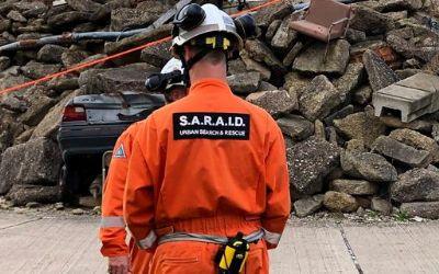
British search and rescue charity SARAID hosted an immersive, natural disaster search and rescue live demonstration day in association with Ground Control and Iridium. Using RockSTAR devices to track team members, contributors were able to showcase how the Iridium Certus platform can work in the field.

The demonstration day was held at the Rig 5 incident ground at The Fire Service College. The unique 300-acre venue can be found at Moreton-in-Marsh in the United Kingdom. It has an impressive collapsed structure, vast rubble pile, and destabilized floors and walls. The enormous grounds and specialist facilities are the perfect environment for identifying where tracking systems would be needed most.

S.A.R.A.I.D.

The main purpose of the demonstration was to show how the Iridium Certus platform can benefit a number of sectors, from military to search and rescue and utility companies. The advanced multi-service platform delivers a reliable connection for voice and data services, including telephony, satellite internet, land mobile radio, and location-based applications. All of which can now all be made possible by the upgraded Iridium constellation.

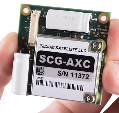
Rock Seven (now trading as Ground Control)’s RockSTAR device was given to each search and rescue (SAR) team member. Certus allowed the people on the ground to get a secure, strong internet connection, allowing them to tap into the RockSTAR tracking applications online. Each RockSTAR transmitted every minute with 15-second updates, giving the team leader a view on where their SAR team members were in the field at all times.

Even their rescue dog in training had RockSTAR strapped to its body to track its position during the exercise. This shows the versatility of our devices and how almost anything that moves can be tracked if it’s big enough to carry the product.
 

Rock Seven (now trading as Ground Control) CEO, Nick Farrell, bore witness to the demonstration. He said: “Seeing SARAID in action was so impressive. We rarely think about the brave men and women, all volunteers, who deploy into disaster zones to help those in need. They work for weeks at a time, helping to find and rescue people trapped in destroyed buildings, risking their own lives in the process – incredibly hard work, with relentless determination and total selflessness.

Anything we can do as a business to help provide better connectivity and situational awareness for SARAID and other similar organizations will hopefully translate into more lives saved.”


In 2018, solar and wind energy production rose to a record high. According to UK-based climate science and energy policy experts Carbon Brief , renewable energy accounted for 33% of all UK energy production in 2018, with wind making up 17%, solar producing 4%, and biomass with the remaining 11%.

Interestingly, while renewable energy is on the rise, analysts have calculated that the electricity used per person has decreased by almost 25% since its peak in 2005, falling to its lowest level since the mid-1990s. This decrease can be attributed largely to individuals making a conscious decision to use their energy more efficiently and economically, and large corporations striving to use more renewable energy to meet regulatory requirements and customer expectations. It’s heartening to see a positive impact from these changes in behavior.

Renewables Growth

Unsurprisingly, we’re now also seeing an increase in the creation of more large-scale photovoltaic (PV) farms, as big players such as Google and Apple compete for the ‘renewable energy crown’. Facebook and Amazon have committed to using 100% renewable energy by 2020. As such, development is now focused on much larger PV schemes to help companies meet their sustainability targets.

The Winds of Change

The Wireless Innovation (now trading as Ground Control) team have supplied satellite and cellular communications to the renewable energy market for many years for wind and solar resource assessment campaigns, array monitoring, and SCADA data.

As wireless communications supplier to the four leading global data logging and data acquisition companies, our clients rely on us to provide the wireless backhaul for their sophisticated measurement campaigns with bespoke cellular, satellite, and hybrid solutions. Once a potential site is identified and an initial desktop survey determines that the site is viable, we supply the communications for the measurement campaign that determines the exact resources available.

We currently deploy communications equipment and airtime to renewable energy sites in over 100 countries, on more than 3,000 sites. Our biggest market is the USA, followed by Europe and the UK, and we’re seeing strong growth in emerging markets like South America. Whereas previously we’ve undertaken a fairly even balance of wind and solar projects, offshore wind projects are increasing significantly, particularly in the UK, as it takes the global lead in this area.

Offshore Renewables Projects

Offshore wind is already a UK success story. We’ve installed more capacity than any other country and offshore wind farms are becoming the backbone of the UK’s energy network. The long-awaited UK Offshore Wind Sector Deal, announced by the government on March 7 2019, is a game-changer for the UK and will see offshore wind go from strength to strength and, in the foreseeable future, dominate the clean-energy landscape.

When operating far offshore, beyond cellular reception and before any fiber optic cables are laid or available, the only way to reliably and securely communicate back to shore is via satellite. As we’re not tied to any particular network, we can create tailored, end-to-end solutions with a robust and secure communication infrastructure, to cover all offshore requirements for both data and voice. For mission-critical data, which often includes SCADA, we use a totally private and secure satellite network service called TSAT, or SCADASat. Wireless Innovation (now trading as Ground Control) is TSAT’s exclusive partner in the UK, so this ‘bullet-proof’ communication channel is available only to our clients.

Any Way the Wind Blows

When measuring the commercial viability of wind plants, clients usually require a minimum of 12 months of measurements for a serious large-scale project, with continuous measurements throughout that period. This gives our clients a good representation of the wind speed and directions over the entire year, as it varies greatly from season to season. Further monitoring is needed when a site passes the energy yield assessment and once the Wind Turbines have been installed. Once the plant has been constructed, key components still need to be measured around the clock in order to ensure that a wind farm is operating at maximum efficiency.

The Future of Renewables Data

Climate change concerns and global pressure to reduce CO2 emissions continue to drive an enormous shift towards renewable energy production. We’re seeing a huge increase in the number of companies seeking more innovative, secure, and cost-effective solutions to overcome the challenges of wireless backhaul for renewable source monitoring. It’s an exciting time to be working in renewables data.

Projects are varied from creating solutions for wind power ramp events, energy storage, integrating distributed data systems and assessment data in remote locations to providing a satellite failover for continuity in the event of natural disasters. Our work is not only having a positive impact in our clients’ businesses, it’s also contributing to global efforts to protect the environment.

Can We Help You?

When it comes to retrieving precise data from distant renewable sites, Ground Control is the solution. With our reliable connectivity, available around the clock and accessible from anywhere, you can achieve seamless data monitoring without any interruptions. We also offer hybrid cellular and satellite connectivity solutions to cater to your specific needs.

No matter what communication or connectivity requirements you have, we are here to assist you. Contact us today to get started.

    Required Field

    Professor Jakob Kuttenkeuler and Jari Krützfeldt of the KTH Maritime Robotics Laboratory at the Royal Institute of Technology of Sweden developed the LoTUS (long-term underwater sensing) buoy, a system for collecting oceanographic data from perhaps the most remote place on the planet – the polar region seafloor. Long-term data about the conditions there are vital for understanding complex processes such as ocean currents, melting and refreezing of ice, circulations etc.

    In the past, the primary tool for investigating these entities were large ship-based expeditions that were both costly and logistically difficult to conduct. The idea behind the LoTUS system is to offer a small, affordable, lightweight and simple-to-use tool for monitoring conditions on the seafloor.

    The LoTUS consists of a spherical polystyrene shell attached to an anchor, known as a bottom lander. The shell can withstand conditions found at depths down to 2000m and contains all the necessary hardware for long-term sampling of temperature, current, conductivity and pressure.

    Upon reaching an area of interest, the LoTUS is launched from a ship (with an aircraft launch in the works) and quickly sinks to the seafloor. Data samples are taken every hour or so, and are stored in the LoTUS EEPROM memory which offers a data retention capability of over 100 years. After a pre-set duration, e.g. 1-10 years, the LoTUS buoy will separate from the anchor thanks to electrolytically accelerated corrosion of a steel coil. The LoTUS buoy will then float back up to the water’s surface which will hopefully be ice-free.

    At the surface, the LoTUS buoy will be thousands of kilometers away from the closest research team and will likely not be collected by an expedition any time soon. Thus, it will be necessary to send its valuable data back wirelessly. It’s here that the RockBLOCK Mk2’s satellite communications capability comes into play.

    As soon as a clear view of the sky is detected by the RockBLOCK, a couple of hundred SBD-messages containing compressed LoTUS data are transmitted up to Iridium. This data is then sent to Rock Seven (now trading as Ground Control) servers which, in turn, push it to an endpoint specified by the research team.

    Following the completion of the first part of its mission as a bottom lander, the LoTUS now has a new lease on life as a drifter beacon. For the next few months, it will measure and transmit both buoy GPS positions and surface water temperature, sending data back to researchers in near real-time.

    With the help of the newly established Iridium link and the Ground Control API, it will then also be possible to reconfigure the LoTUS buoy’s sampling interval and duration so as to save battery and extend the surface mission further.

    Get in touch

    If you have a remote IoT connectivity challenge, there's a very good chance we can help! With over 20 years' experience in satellite communications, and long-term relationships with trusted satellite constellation operators like Iridium, we're well placed to help you backhaul your data cost-effectively and reliably from anywhere on Earth with a clear view of the sky.

    Call or email us, or complete the form, and we'll be happy to connect you with one of our solutions architects to discuss your requirements.

    On March 28th 2019, Iridium announced that their new southern hemisphere ground station was brought online in the south of Chile. This new site is a significant breakthrough and improvement for the network, as it marks the first southern hemisphere station to be introduced. This location strengthens Iridium’s already renowned space and ground network by increasing their ability to maintain and manage traffic, capacity and availability rates.

    This particular site was built in partnership with Kongsberg Satellite Services (KSAT) of Norway, who have long been a close partner with Iridium, working closely to improve and support celestial-to-terrestrial connectivity.

    Thanks to Iridium’s status as the only satellite provider who can boast having a low-earth orbit commercial network to use intersatellite cross-links, satellite traffic can now be transferred in real-time via the most practical and efficient route, further enhanced by the new Punta Arenas site. These cross-links enable all data to be moved from satellite to satellite and finally down to various ground gateways automatically, with minimal delay. This ensures that Iridium remains the worlds first, and only, truly global network that allows users to communicate from any location including the north and south poles, and everywhere in between.

    Though technically, Iridium can maintain all traffic simultaneously through a single gateway, they have always maintained multiple ground stations located throughout the northern hemisphere. With this new station in Chile, they have now increased visibility to their satellites as they pass through their southern hemispheric orbits, as well as further geographic diversity to further improve overall network resilience.

    This site joins the existing stations in Alaska, Svalbard, and Arizona. Thanks to Iridium’s web-like coverage of the globe, achieved through 11 satellites for each of the six orbital planes, this architectural design ensures all corners of the globe have satellites in view at all times, minimising the need for local infrastructure or ground stations. Having multiple stations ensures that, should a station fail, there are four others to pick up the traffic to guarantee its timely and successful delivery.

    If you’d like to read more about Iridium’s new station, as well as their revolutionary new upgrade, Iridium NEXT, and what this means for existing users, then visit their website here.

    Get in touch

    Ground Control is a Tier 1 Iridium Reseller. We have been working with Iridium for over 10 years, and also design and build hardware like the RockBLOCK that uses Iridium SBD to communicate. In short, you're in safe hands.

    Please get in touch for more information or to set up an account – we are here to help and assist. For large deployments, we are often able to create custom tariffs and pricing schemes, so don’t hesitate to ask.

    The Maker Buoy is a low-cost, Arduino-based, solar-powered and open-source drifting buoy available to purchase ready-made or for the end-user to construct themselves following simple instructions.

    The goal is to provide a tool so that we can gain invaluable knowledge about ocean currents, climate and to improve forecasting. Making sure it is easily accessible by hobbyists, researchers and organisations is the key to making the most of the vast amounts of information that can be gleaned from studying our oceans.

    The primary purpose of these long-lasting buoys is to measure ocean currents and sea temperature. This information is usually transmitted over satellite networks to oceanographers who are back in their labs on the mainland. The current of the ocean surface and various temperature readings provide vital intel for weather and climate models. Some drifters are even thrown in the ocean in the path of typhoons and hurricanes to gain a better understanding of ocean behaviour, as well as bettering our understanding of intensity forecasting.

    Created by engineer Wayne Pavalko, a mathematician by training and an engineer from John Hopkins University Applied Physics Laboratory in Maryland, these buoys are readily available and incredibly easy to build from scratch.

    Comprised of a Ground Control RockBLOCK 9603, 1 W solar panel, custom board, a 2AH battery, 3D-printed internal frame, Adafruit GPS, a few cable ties, and its own waterproof case, you have an incredibly robust, low-impact buoy that will last a lifetime in the ocean and can be assembled in under 10 minutes. Early designs of the buoy deployed in 2016 lasted over two years and travelled more than 9000 miles, sending valuable data the whole time. Since 2016, the design has been made smaller, cheaper, and far easier to construct, without sacrificing its robustness.

    If the idea of creating your own buoy, programming the RockBLOCK 9603 and retrieving your own oceanic data is appealing, head on over to the Maker Buoy website for a quick read up, or reach out directly to makerbuoyshop@gmail.com for all inquiries.

    You can also check out how easy it is to build a buoy, in under 10 minutes below:

    Get in touch

    Get in touch with us and find out if the RockBLOCK 9603 is the right device for your needs. Either complete our online form, or call us to be connected directly with one of our expert team. Call +44 (0) 1452 751940 (Europe, Asia, Africa, Oceania) or +1.805.783.4600 (North and South America).

    With over 20 years experience in satellite tracking we have the knowledge and experience to ensure you are equipped with everything you need to make the right choice.

    James Dziadulewicz B.S. Eng. Mech & electronics engineer has built a one of a kind home in Malibu, California. His incredible home is situated on 10 acres of land in a high fire risk zone. Knowing that his home is susceptible to bushfires, James wanted to install a system that would protect his home from any impending danger. As a result of the potential threat of fires, he created the Hot Shot system – an automated, off the grid fire prevention system.

    He installed a solar system with a backup generator and, using their own water supply, trenched irrigation lines and setup 12 high-pressure sprinklers around the perimeter of the home and their powerhouse trailer. He connected it all up to a 2.0 HP irrigation pump and electronic solenoid. He also used Arduino components to take transmitted messages and use them to turn the pump and solenoid on and off at will.

    Knowing that he lived in an area that could potentially be completely cut off from cell phone reception and power if the towers were disabled during a fire, James decided that he needed a 100% reliable communication system so that he could receive and send messages to enable his system. He discovered the RockBLOCK and, realising it ran off of the Iridium Satellite Network, installed one to be used as the transmitter. Paired with an external helical antenna, this guaranteed that any messages sent to or from the RockBLOCK would be transmitted reliably.

    RockBLOCK 9603

    The smallest and lightest version in our RockBLOCK family, the RockBLOCK 9603 is targeted primarily at systems integrators and product developers where space inside your enclosure is at a premium. RockBLOCKs can send and receive short messages from anywhere on Earth with a view of the sky.

    With an app created by his friend, Matthew Jenks B.S. Eng. software & M.S. Eng. electrical engineer, James was able to activate the system 54 miles away from his home using his phone, when he received from the sensors attached to the system that the fire was getting closer. He activated the system 35 minutes before the fires hit the area. This was more than enough time for the high-pressure sprinklers to activate and douse his home and the surrounding area, effectively making the area impervious to the fires. His home was left completely unscathed.

    While the RockBLOCK is small, it’s a vital part of the system. It worked so well it is now patent pending, and we’re thrilled that we played a part in saving James’ beautiful home. We’re hoping that this system will start to roll out over areas with high fire risk, with one large home in Thousand Oaks, California, already signing up for one.

    Can we help you?

    Get in touch with us and find out if the RockBLOCK 9603 is the right device for your needs. Either complete our online form, or call us to be connected directly with one of our expert team. Call +44 (0) 1452 751940 (Europe, Asia, Africa, Oceania) or +1.805.783.4600 (North and South America).

    With over 20 years experience in satellite tracking we have the knowledge and experience to ensure you are equipped with everything you need to make the right choice.

    Using a locally sourced cellular SIM card, or global cellular SIM provided by us, that’s loaded with cellular data, you now have the option of sending tracking reports once every 15 seconds, whenever you’re operating in cell range. The best part? There’re no additional charges for these faster reports.

    Traditionally, when you purchase a bundle of credits from us to operate your tracking device, every single position report will use one credit. Now, with the option of cellular tracking, these messages won’t diminish your credit pool – instead, these cellular positions are free. You can even have your RockAIR send these cellular position reports faster than satellite ones to make sure you don’t burn through your credits too quickly.

    Beyond the obvious cost savings, this is also a very useful safety feature. With the incredible cellular coverage the world’s now experiencing, search areas for aircraft using cellular tracking will now drastically decrease. By using the power of dual sat/cell tracking, you get complete peace of mind regardless of the location you’re flying in.

    For example, if you’re flying at 100 knots using a satellite-only device to transmit at a typical two-minute interval, your potential search area is roughly 116 sqkm (72sqm) if something were to happen. However, if you were using a dual mode device, such as a RockAIR, and you were reporting within cellular range at 15 seconds, the potential search area is significantly reduced to a very small 1.9sqkm (1.18sqm).

    The RockAIR intuitively changes between satellite and cellular modes as well. If the unit is struggling to retrieve a cellular signal from its GSM antenna, then it will stop trying to send via cell and will switch to satellite tracking – seamlessly. There’ll be no downtime during this switch.

    Dual mode tracking is incredibly easy to set up as well:

    1. Open up RockCONNECT on your smartphone or tablet.
    2. Select the RockAIR you’d like to connect with, assuming it’s turned on.
    3. Select ‘Configure’ then type in ‘1234’ if prompted for a pin.
    4. Select ‘Tracking > Satellite Context’ and change the ‘Transmit Frequency’ to your preferred satellite tracking rate.
    5. Select ‘Tracking > Cellular Context’ and change the ‘Transmit Frequency’ to your preferred cellular tracking rate.

     
    And that’s it. You’re ready to send tracking reports on either cellular or satellite.

    Navigating to the ‘Alerts’ section within the main menu of your RockSTAR, you’ll be greeted by six alert types and an alert cancel. Here’s what each one means:

    1. Timer Alert

    The idea behind the timer alert is a one-time alert after a set time limit has expired. Set the timer for a time interval of your choosing. Once that time has expired, a ‘timer alert’ is sent from the RockSTAR to the server/first responders. They’re now aware that the timer has expired without human interaction turning it off. This is a one-time alert. The timer doesn’t reset afterwards.

    Possible Use Case:
    You’re in a remote location and are expected to be doing a job for 30 minutes. Set the timer for 60 mins and if it goes off then your responders know that you have taken twice the amount of time expected and they should do their level best to make contact.

    2. Dead Man’s Switch

    This is similar to the timer alert, except this is a recurring alert. Once the timer has been set, you’ll have 20 seconds before that time frame reaches its limit to push the ‘ok’ button to cancel the alert from being sent. You’re notified of this 20-second window by loud, consistent beeping from the unit. Once the timer cycle has completed, or you’ve pressed the ‘ok’ button during the beeping sequence, it refreshes and starts again.

    Possible Use Case:
    If you’re in an unsafe territory or doing a dangerous task, the dead man’s switch is a brilliant idea to ensure that you are constantly checking in with your team to assure them you’re ok and unharmed. As RockSTARs have set frequencies to send position reports, the dead man’s switch guarantees the unit hasn’t been left lying around giving off the impression that you’re safe, when you actually need assistance.

    3. Temperature Alert

    This is triggered when the values you have set are exceeded. You can set the high and low temperatures to values you think reflect the environment you’re operating in. These values relate to the RockSTAR board and circuitry, so the exterior might be incredibly hot or cold, but it’s the interior components that are being monitored. Once these temperatures are exceeded, an alert is sent so you can regulate the temperature.

    Possible Use Case:
    If you’re fighting fires or doing research in a cold environment, this alert is perfect to ensure you don’t damage your device.

    4. Power Alert

    If you’ve connected your RockSTAR to an external power source, then once the external power is removed, the unit detects ‘power loss’ and will send a message accordingly. If you have set your unit to ‘power mode’, so it only turns on with external power, and you remove the power source, then it will stay awake long enough to send a ‘power loss alert’ to the server. This way, each time the unit is turned off, someone is alerted.

    Possible Use Case:
     If you’re driving long distances in remote areas and require tracking without having to worry about battery life, then power loss alerts are a great way to inform you if your tracking has stopped, without having to wait for the scheduled report to be missing from the mapping.

    5. Geofence Alert

    There are two options for Geofence Alert – user and polygon. We’ll talk about user here. To learn about polygons, contact our support team and they’ll explain further.

    A geofence draws an imaginary circle around a center point, and if that circle is left, an alert is sent notifying you of that breach. By pressing ‘centre point’ in this menu, you’re allowing the RockSTAR to record your GPS location. It then draws a circle based on the distance you’ve chosen. You then select how often you want the unit to check to see if you’re still in that circle. As soon as you leave it, an alert is sent.

    Possible Use Case:
    If you’re assigned an area for a specific reason – research, pest control, etc. – then geofences are a great way to ensure you keep to your assigned area and don’t encroach on prohibited or protected land.

    6. Collision Alert

    Inside each RockSTAR is an accelerometer. If you set the threshold of the unit to an appropriate G-force value and the duration that the unit sustains that G-force is exceeded, the accelerometer measures this and will send an alert notifying of this exceedance.

    Possible Use Case:
    Any situation that the unit is installed in a vehicle, this alert is a great tool to determine if the vehicle has sustained a server impact. By altering the threshold and duration, you can ensure that the unit only triggers when a crash occurs, as opposed to hitting uneven ground at speed.

    Send Alert Cancel

    Any time that an alert has been sent that you couldn’t stop in time, sending a cancel message will allow the responders to know not to misinterpret the alert that was just received.

    If you’d like to know anything further about these alerts, or geofence polygons, don’t hesitate to reach out to our support team and we’ll do our best to assist.

    Get in touch

    We take pride in designing and building the RockSTAR ourselves. Over the years we've enhanced and added features based on feedback and specific customer requests, to ensure our device meets your needs.

    Simply complete the form to find out whether the RockSTAR is the right fit for your organization. With our 20 years of expertise, we'll guide you in making the optimal choices for your critical communication requirements. If you prefer to speak to someone directly, call us on +44 (0) 1452 751940 (Europe, Asia, Africa) or +1.805.783.4600 (North and South America).
    Call or Email Us

    The Space Economy

    Iridium is the only mobile voice and data satellite communications network that spans the entire globe pole to pole. It enables connections between people, organisations and assets to and from anywhere in the world, in real time. Wireless Innovation (now trading as Ground Control)’s partnership with Iridium helps us to deliver innovative end-to-end solutions, tailored for each of our client’s specific needs, to provide a complete view of their data to enable better business decisions.

    SpaceX, who design, manufacture and launch advanced rockets and spacecrafts, are currently helping providers to launch satellites in their thousands, which means that the total number of satellites in orbit is set to double by 2027; reaching almost 20,000.

    These satellites are bringing cost-effective internet connectivity to businesses and individuals in remote and challenging locations where it has previously been unavailable, opening up a host of new business opportunities and enabling more effective business management. The Economist anticipates that this increased accessibility will see the space economy grow from £275 billion (in 2016) to nearly £1 trillion by 2040. New internet satellites will account for half this increase.

    Iridium NEXT-8 Launch Campaign

    Approaching the end of a two-year campaign, Iridium has been working with SpaceX to replace their existing satellite constellation. This involves sending 75 Iridium NEXT satellites into space on a SpaceX Falcon 9 rocket during a series of eight launches.

    65 of those satellites have already been placed into orbit and to complete deployment of Iridium’s second-generation constellation the final ten will lift off this month from California’s Vandenberg Air Force Base. Nine of the total NEXT 75 satellites launched will serve as on-orbit spares and another six will be left on the ground to serve as further spares, in case they are needed during the life-cycle of their new constellation.

    Once the final ten are launched they will deploy into the same orbital plane, within a month, to complete a 100% Iridium NEXT network.

    We are looking forward to the resolution of Iridium’s highly anticipated global satellite constellation refresh. This historic project is not only one of the most significant commercial space ventures, but the completion will welcome an unrivalled technological platform for innovation in data and communication solutions. The power of this constellation will facilitate a host of advanced services, which will utilise even smaller and more cost-effective terminals, turbocharging Iridium satellite connectivity and providing the world’s fastest global L-band broadband service.

    The Ultimate Launch Soundtrack

    In early 2019, Iridium created their very first satellite launch playlist on Spotify. They’ve been collating a new playlist to commemorate the final launch featuring songs that will complement the SpaceX launch webcast and reflect the Iridium story.

    The completion of this Iridium NEXT constellation is redefining the capabilities of mobile satellite communications, powering Iridium Certus to deliver the next generation of broadband, critical safety, disaster recovery, L-band communications, and data solutions to businesses and individuals in every industry, all over the world.

    Get in touch

    Ground Control is a Tier 1 Iridium Reseller. We have been working with Iridium for over 10 years, and also design and build hardware like the RockBLOCK that uses Iridium SBD to communicate. In short, you're in safe hands.

    Please get in touch for more information or to set up an account – we are here to help and assist. For large deployments, we are often able to create custom tariffs and pricing schemes, so don’t hesitate to ask.