Last updated
When GNSS Can’t Be Trusted: How Independent Is The Rest Of The Bridge?
“The maritime sector is one of the most GNSS dependent sectors of the UK economy. Position, Navigation, and Timing (PNT) data are used at all stages of maritime journeys for navigation and safety purposes, from oceanic and coastal navigation to maneuvers in ports.” (UK Government.)
The quote is UK specific, but the underlying dependency is familiar across commercial and naval operations: GNSS supports considerably more than the vessel’s position on a chart. That dependency becomes more significant as interference becomes more frequent and affects a wider range of operating environments.
In January 2026, the coastal states of the Baltic Sea and the North Sea, together with Iceland, warned of growing GNSS interference and called for stronger vessel capabilities, crew preparedness and alternative radio navigation systems. Geopolitical instability continues to affect established shipping routes. The map below shows a high-level estimate of GNSS interference hotspots derived from reported disruption in 2026.
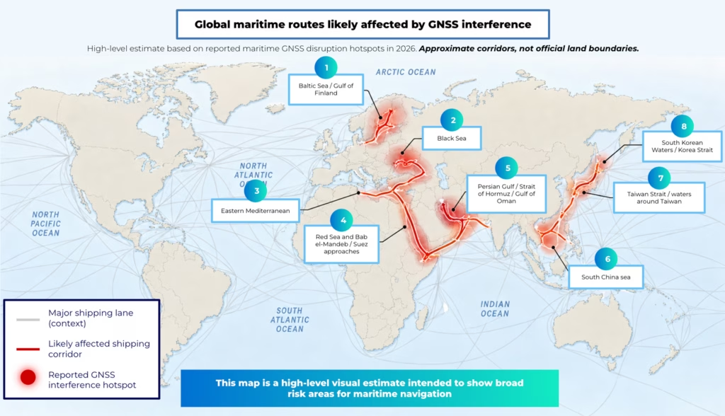
Indicative GNSS interference hotspots based on publicly reported maritime incidents and safety reporting in 2026. Not exhaustive.
The implications of that disruption extend beyond an unreliable position fix. Research from the Royal Institute of Navigation highlights how GNSS-derived information can propagate through systems well beyond the dedicated positioning receiver. The RIN’s 2026 maritime research identifies dependencies involving equipment including radar, radios, NAVTEX, speed logs, ship clocks and satellite communications.
Bridge teams already have established responses to GNSS denial and interference, drawing on radar, AIS, inertial systems, visual observations, manual fixing, procedures and professional judgment. These remain important ways of navigating through GNSS disruption. But where several bridge systems ultimately depend on GNSS-derived data, having multiple sources of information doesn’t necessarily mean having multiple independent sources of position.
For crews operating through GNSS denial and interference, this raises a wider systems question: When several systems remain available, how independent are the sources behind the information they present, and how much confidence can be placed in them?
Proven Ways to Manage GNSS Disruption
Experienced crews don’t depend on a single display. Radar provides range and bearing information on coastlines, fixed structures, vessels and other targets. Visual observations and manual fixes remain available where conditions permit. Inertial navigation and dead reckoning can maintain an estimate of vessel movement when external position updates are lost. AIS contributes traffic, identity and positional information.
These are established layers of navigation practice, and current guidance continues to recognize their importance. The IMO, ICAO and ITU have called for greater resilience of GNSS-dependent positioning, navigation and timing systems, while also supporting conventional navigation infrastructure for contingency use.
Their value during GNSS disruption, however, depends not only on whether they remain available, but on how independently their information is derived. Radar fixes and visual observations can provide evidence independent of GNSS. Inertial systems can continue estimating movement, although their uncertainty develops over time without external aiding. Other information presented on the bridge may still depend directly or indirectly on GNSS.
AIS is an important example. Vessel position is typically derived from an electronic position-fixing source, meaning that during GNSS interference, the integrity of the information feeding AIS matters too. A January 2026 interference event near Los Angeles and Long Beach illustrates how this can appear in live traffic. AIS reports from at least seven vessels showed position jumps indicative of spoofing, while one vessel stopped transmitting AIS for nearly an hour, likely because its GNSS solution had become invalid. The incident illustrates a broader problem: information can remain visible across several bridge systems without those systems providing genuinely independent confirmation of position.
Shared Dependencies Across Bridge Systems
A modern bridge can present position information in several places while some of those systems ultimately consume the same underlying data. The RIN maritime research identifies dependencies between GNSS receivers and a range of onboard electronics.
IMCA’s 2026 guidance on GNSS jamming and spoofing in dynamic positioning operations similarly warns that interference can degrade several GNSS based position reference systems simultaneously, creating the potential for common mode failure. A well documented incident involving the tanker Atria showed this problem clearly. When the vessel’s reported position was displaced by around 25-30 miles, the crew restarted both the primary and backup GPS units. Both returned the same false position. Alarms were triggered across the bridge, and approximately 20 nearby vessels were reported with similar anomalies.
IMCA notes that spoofing may produce stable but incorrect position data, while integrated or blended systems can mask an underlying GNSS problem.
Live Trinity House jamming trials provide another example of how an error can propagate. Relatively low power interference caused a gradual position error that affected the vessel’s autopilot and altered its course before bridge alarms were triggered. At higher interference levels, full GPS denial produced alarms across multiple bridge systems.
Establishing Which System Information Can Be Trusted
Detecting interference is only the first step. Cross-checking can show that something is wrong, but it doesn’t automatically establish which source is right. Once available references begin to disagree, crews face a question of diagnosis and confidence:
- Which source has moved?
- When did the discrepancy begin?
- Which connected systems are receiving the suspect position?
- Are apparently separate systems actually using a common source?
- What information remains sufficiently trustworthy for the operation underway?
This is particularly important during spoofing, as while a clean GNSS loss can be relatively obvious, a plausible false position may continue to move smoothly and be distributed across connected systems. The bridge can therefore continue to present coherent-looking information even when some of the underlying data is no longer reliable.
The Nautical Institute notes that GNSS disruption can produce incorrect ECDIS positions, affect GNSS-fed radar or ARPA information and contribute to gyro-related alarms, with multiple alarms potentially occurring at the same time. In that situation, the key challenge is understanding whether the problem is isolated to one system or being propagated through several systems that share the same underlying data.
The Gap Between Signal and Confidence
The confidence problem can continue after the interference itself appears to have ended. Restoration of a GNSS signal doesn’t always immediately restore confidence in the position it reports.
Public incidents show why the two may not happen at the same point. In the Atria incident, restarting both GPS receivers still produced the same false position. During the January 2026 LA/Long Beach event, one vessel’s AIS remained unavailable for nearly an hour. Recovery can depend on receiver behavior, system integration and the checks required before the resulting information can again be treated as trustworthy.
Where several connected systems have inherited the same suspect data, establishing that the returning position is credible can take longer. Even when conventional GNSS begins reporting normally again, crews may still need evidence that the position is credible before confidence can be restored.
In that situation, the missing piece is an independently derived point of reference against which the returning GNSS solution, and the systems dependent on it, can be assessed.
Where an Independent Position Reference Adds Value
Maritime resilience guidance points towards a layered approach combining crew preparedness, conventional navigation techniques, diverse technical references and more resilient PNT capabilities.
Iridium PNT provides one such reference. It delivers positioning, navigation and timing using the Iridium Low Earth Orbit satellite constellation, with a separate constellation, signal and frequency band from conventional GNSS. This allows its position to be compared directly with the GNSS-derived position being assessed.
If the two agree, that provides additional evidence in support of the reported position. If they diverge, crews have an indication that the GNSS-derived information requires further investigation.
What Does This Look Like During Real GNSS Interference?
RockFLEET Assured applies this approach by combining conventional GNSS with an independent position derived from Iridium PNT. The system continuously compares the two positions and can raise an alert if GNSS is lost or they diverge beyond configured parameters. A bridge display presents both positions and tracks together, while NMEA interfaces support integration with compatible onboard equipment.
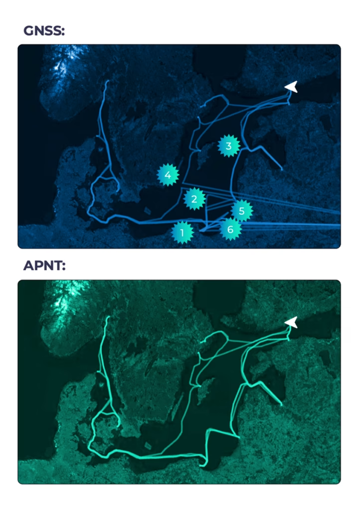
A 2026 live trial provided an example of how that reference can behave during real interference. During the trial, six GNSS jamming or spoofing events were reported onboard a large passenger vessel operating in the Baltic Sea. During one of the clearest events, on a voyage between Baltic ports, the vessel reported the loss of several positioning systems, including GNSS, SAT-C and Fugro.
Ground Control’s recorded data showed RockFLEET Assured continuing to report an Iridium PNT-derived position through the disruption until the vessel reached port, and conventional GNSS returned. The onboard display recorded the GNSS and A-PNT tracks separately, allowing the behavior of the two sources to be compared throughout the event.
At the same time, position and event data remained available through Cloudloop for shore-side monitoring, audit and interrogation. This provided the shore team with an evidence trail that could support subsequent technical, legal or insurance review.
Resilience Depends on Genuine Independence
Bridge resilience already combines equipment, procedures and professional judgment. Increasing GNSS interference adds another consideration: understanding where common dependencies exist when the wider navigation picture becomes uncertain.
For ship owners, navigation teams and technical operators, the question is whether the systems already installed provide enough independent evidence to assess position confidently when conventional GNSS becomes unreliable.
Talk to Our Technical Team
Ground Control can provide further technical information on RockFLEET Assured solution, its integration options and evidence from current operational deployments. Complete the form and one of our technical team will be in touch.