Topic: Drones
ETH Zurich’s Autonomous UAVs Utilizing the RockBLOCK
The Autonomous Systems Lab (ASL) of ETH Zurich has developed the AtlantikSolar and SenseSoar2, two solar-powered, low-altitude long-endurance (LALE) unmanned aerial vehicles (UAVs) that are gathering valuable data on climate change and Agriculture.
Due to their lower cruising height and increased flight endurance, LALE UAVs benefit from improved imaging capabilities, lower complexity, and simplified handling. Unfortunately, they also have to deal with a more challenging meteorological environment in the form of clouds, rain, wind gusts, and thermals.
Designed for multi-day perpetual flight, the AtlantikSolar broke the flight-time world record for its size class in 2015, with an 81-hour, 2338km voyage, while also achieving a 39% minimum state-of-charge. The AtlantikSolar weighs in at 6.9kg and has a wingspan of 5.7m. It now completes multi-day missions using small optical or infrared cameras. Last summer in Greenland, the AtlantikSolar monitored iceberg calving in Greenland – a still poorly understood process which plays an important role in sea-level rise.
With a wingspan of 3m and weighing in at 5.2kg, the SenseSoar2 is a more compact platform. It’s even more robust, though, in dealing with wind gusts and other inclement weather conditions. In fact, this summer, SenseSoar2 completed a 302km, 5.5-hour flight while being battered by high winds.
The SenseSoar2 is currently being used in an ongoing ESA agricultural monitoring mission in the Ukraine. Fitted with a hyperspectral camera that complements existing satellite imagery, it provides farmers, agronomists, and agricultural experts with actionable intelligence.
Rock Seven (now trading as Ground Control) RockBLOCKs are used to send telemetry to the ground station and commands to the UAVs when radio transmission is not feasible. To achieve this, the team integrated a RockBLOCK to the PX4 open-source autopilot via the PX4’s API, giving the ground station fly-by-satellite capability when the AtlantikSolar and SenseSoar2 were downrange of the 868MHz medium-range telemetry link.
Get in touch
Get in touch with us and find out if the RockBLOCK 9603 is the right device for your needs. Either complete our online form, or call us to be connected directly with one of our expert team. Call +44 (0) 1452 751940 (Europe, Asia, Africa, Oceania) or +1.805.783.4600 (North and South America).
With over 20 years experience in satellite tracking we have the knowledge and experience to ensure you are equipped with everything you need to make the right choice.
Octanis Rover Mission
Operating out of the École Polytechnique Fédérale de Lausanne, Octanis is a 30-member strong not-for-profit student/alumni association focused on enabling rapid prototyping locally. Anyone interested in sciences, engineering, or making can become a member.
It was the need for a low-cost, minimal environmental impact platform for scientific experiments in extremely cold temperatures, that led the association to develop the Octanis Rover.
The rover was designed to be weatherproof, cold-resistant, and lightweight, while robust enough to complete a multi-month mission autonomously. From November 2016 to January 2017, Octanis successfully field-tested the rover in Antarctica on a research mission to create a map of the snow surface using the rover’s low-cost laser scanner.
Using differential GPS (dGPS), stereo cameras, and LIDAR, an operator in the field chose waypoints for the rover’s goal-to-goal navigation. At the same time, its internal and external sensors would regularly gather and transmit telemetry back to a nearby field base station via LoRa radio.
At the station, the mission’s waypoints and sensor telemetry were transmitted via RockBLOCK back to Switzerland, allowing the research team to see how the Octanis rover was operating and to ascertain whether its sensors were producing good data.
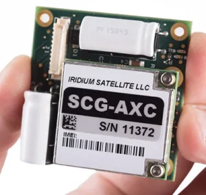
RockBLOCK 9603
RockBLOCK 9603 is targeted primarily at systems integrators and product developers where space inside your enclosure is at a premium.
RockBLOCKs can send and receive short messages from anywhere on Earth with a view of the sky.
All Octanis software and hardware has been specifically chosen to adhere to the principles of the open source movement, and the RockBLOCK is no exception. The publicly available Rock Seven (now trading as Ground Control) API allows users to deliver messages from RockBLOCKs directly to their own application’s web service or e-mail, and to send messages or commands back to RockBLOCKs in the field.
Mapping Ocean Fronts with Robotic Fleets and the RockBLOCK
Led by Dr. João Borges de Sousa of the Laboratório de Sistemas e Tecnologia Subaquática (LSTS) of Portugal, a multinational, multidisciplinary team of scientists have designed, built, and deployed seven autonomous underwater vehicles (AUVs) in the North Pacific Subtropical Ocean Front using the Schmidt Ocean Institute’s research vessel Falkor.
Ocean fronts are areas where drastic changes occur in the properties of waters. These changes are of interest to scientists studying Earth’s climate and marine ecosystems. The particular ocean front examined by the teams is situated about 1,000 nautical miles SW of Southern California. It’s here that less dense and cold waters coming from the Arctic meet the otherwise saline waters of the Pacific.
Three scout ASVs (autonomous surface vehicles) were sent to detect the ocean front ahead of the Schmidt Ocean Institute expedition. The area was then mapped for three weeks by a fleet of AUVs, UAVs (unmanned aerial vehicles) and the R/V Falkor.
In order to map the 3D structure of this dynamic front, the AUVs cycled in a ‘saw-tooth’ pattern between the water’s surface at a depth of 100 meters. The AUVs were controlled from either the R/V Falkor or across the world from an ocean space center in Portugal, with commands sent via RockBLOCKs and the Iridium network.
Operating 24/7, the AUVs would also periodically upload preliminary sensor data, like temperature, salinity, chlorophyll, and turbidity profiles (water properties at different measured depths).
When interesting features would appear, UAVs were deployed to measure the same features from the air using thermal and multispectral cameras. This feat wouldn’t have been possible using only traditional marine/aerial vehicles, due to the logistical and financial restrictions involved with these larger assets.
In less than three weeks, the AUVs traversed over 1,000 nautical miles, operating approximately for 500 hours and sending over 12,000 transmissions – or 2.5 megabytes of Iridium data – to researchers via Rock Seven (now trading as Ground Control)’s servers.
The mission’s success proves that lower-cost, autonomous, and connected vehicles can play a key role in collecting abundant data sets from remote locations. This allows research vessels like the R/V Falkor to shift their role from being a primary sampling unit to a command center, reducing operational costs while increasing scientific knowledge.
Iridium connectivity also allowed the replica command center based in Portugal to take over the second shift, giving scientists round the clock control of their research assets.
More information about this research can be found in the Schmidt Ocean Institute’s expedition page.
Get in touch
Get in touch with us and find out if the RockBLOCK 9603 is the right device for your needs. Either complete our online form, or call us to be connected directly with one of our expert team. Call +44 (0) 1452 751940 (Europe, Asia, Africa, Oceania) or +1.805.783.4600 (North and South America).
With over 20 years experience in satellite tracking we have the knowledge and experience to ensure you are equipped with everything you need to make the right choice.