Last updated
Designing UAVs for GNSS-Denied Environments
GNSS has been fundamental to modern navigation for decades, telling UAVs where they are, supporting waypoint navigation, informing geofencing and flight control, and enabling functions such as Return to Home. A wide range of autonomous capability has been built on the assumption that this position can be trusted.
Discussion of GNSS disruption tends to treat it as binary: an aircraft either has GPS or it doesn’t. In practice, developers have to design for a wider range of conditions. Interference can reduce accuracy or make a fix intermittent. Jamming can overwhelm the relatively weak GNSS signal reaching the receiver. Environmental factors introduce multipath and other error sources. Spoofing is a different kind of problem entirely: the receiver keeps producing data that looks like a valid fix.
That last case is the one that matters most. A flight computer can keep receiving latitude, longitude and timing information and keep acting on it, with no obvious sign that the underlying position has been compromised. A system can be designed to recognize the absence of data. Recognizing data that looks legitimate but shouldn’t be trusted is a different problem, and it’s why position integrity has to be treated as seriously as position availability.
The issue becomes more significant as UAVs fly further from their operators and take on more of the decision-making themselves. A human operator can often sense that something is wrong and intervene. An autonomous aircraft needs that judgment built into its navigation architecture, since there’s no one watching to catch the mistake.
Stop Looking for a GNSS Replacement, Build Independence Instead
The instinct when discussing alternative navigation technologies is to look for whatever will replace GNSS outright. That’s not the most useful framing for UAV developers. GNSS remains an excellent, highly capable positioning source with a vast supporting ecosystem, and for most platforms it should stay central to the navigation stack. The better question is how to build enough diversity into the architecture that losing or compromising one source doesn’t leave the aircraft with no way to check its position at all.
Several technologies can contribute to that diversity, each with real limitations. Inertial navigation estimates movement independently of satellites, but its errors accumulate over time. Cameras and visual navigation add useful information about movement and surroundings, but depend on conditions and available reference points. Radar, terrain matching and signals of opportunity can all add evidence depending on the platform and mission. None of these replaces GNSS on their own. What matters is how they’re combined, and specifically, what the system does when they stop agreeing with each other.

Why Another GNSS Constellation Isn’t Real Independence
Adding a second GNSS constellation doesn’t create the kind of diversity this requires. GPS, Galileo, GLONASS and BeiDou can deliver excellent combined performance, but they remain GNSS technologies, built on the same underlying infrastructure and vulnerable to many of the same failure modes.
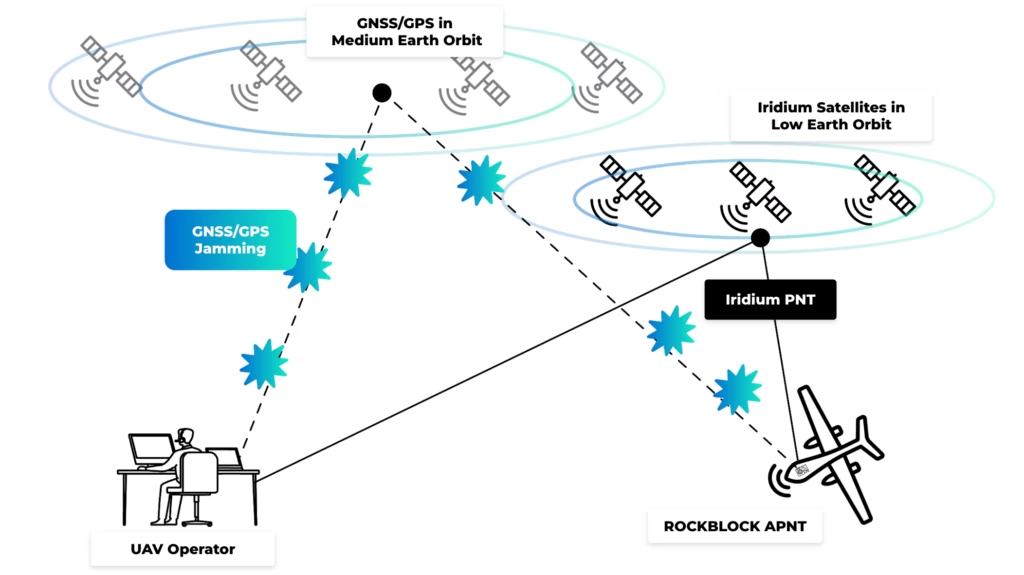
Assured Position, Navigation and Timing (A-PNT) is one way to introduce genuine independence. Ground Control’s approach uses Iridium PNT, delivered through the Iridium Low Earth Orbit satellite network, as a position and timing source that sits entirely outside conventional GNSS infrastructure. Its signals are approximately 1,000 times stronger at the Earth’s surface than typical GPS/GNSS signals, which makes them substantially more resilient to jamming. Combined with encryption and signal authentication, this gives Iridium PNT a genuinely different resilience profile, and makes it considerably harder to spoof in the way GNSS can be spoofed.
The value for a UAV developer lies in that separation from GNSS, not in Iridium PNT being more accurate. When GNSS is degraded, jammed or compromised, it gives the aircraft something else to check its existing navigation data against.
What Disagreement Between Sources Actually Tells You
Picture a UAV in flight with GNSS, an IMU and an independent Iridium PNT position all feeding its navigation system. Under normal conditions, these sources should broadly agree, though not identically, since each has different accuracy characteristics and its own margin of uncertainty. The system can learn what normal agreement looks like.
Now picture the GNSS-derived position starting to drift away from the independent one. That divergence is useful information, but it isn’t automatic proof of spoofing. Positioning sources can legitimately disagree for other reasons, so a properly engineered system has to weigh accuracy, uncertainty, latency and the platform’s own dynamics before drawing a conclusion. What this really provides is another piece of evidence, derived from a fundamentally different satellite infrastructure, that the aircraft can weigh alongside GNSS rather than trusting GNSS in isolation.
Once divergence is detected, the host system has to decide what to do with it. A developer might set acceptable thresholds between GNSS and the other position source based on each source’s expected accuracy, with divergence beyond that threshold feeding into navigation weighting, a change of flight mode, an operator alert, or a contingency procedure.
What’s appropriate depends entirely on the mission and the consequences of getting it wrong: a small commercial drone flying near its operator carries a very different risk profile from an autonomous aircraft flying BVLOS in a contested environment. A-PNT should be designed as part of that decision architecture rather than bolted on as a standalone fix. Its value, for a UAV operating beyond reliable human oversight, comes from giving the aircraft another trusted reference to measure its existing information against.
Integrating RockBLOCK APNT
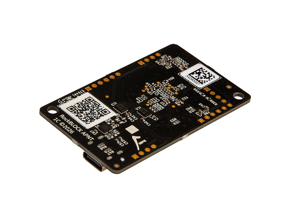
Historically, accessing an independent satellite-derived PNT source meant a significant hardware development effort before a team could even begin evaluating how it would behave in their application. RockBLOCK APNT is built to remove most of that barrier. It combines the Iridium PNT ASIC with the power, antenna and host interfaces needed to evaluate and integrate the service, without requiring developers to design their own PCB around the chip.
The board measures 59 × 36.5 × 7.7 mm and weighs around 10 g, sized for embedded designs where size, weight and power all matter. It runs from 5V over USB-C or 3.3V through its embedded power connection, with peak consumption of 1.2W. USB-C gives a quick starting point for evaluation and software development, while LVTTL UART, SPI, I²C and GPIO interfaces support integration into a larger embedded system, alongside a 1PPS output for timing applications.
RockBLOCK APNT doesn’t contain a conventional GNSS receiver. It provides the independent Iridium PNT position and timing source, and leaves it to the UAV’s host platform to decide how that data is compared against GNSS, inertial, visual or any other navigation input available to the aircraft. It receives Iridium PNT through an external antenna, so antenna selection and placement remain part of the integration work, and the board itself is a PCBA rather than a ruggedized finished unit, built to be incorporated into whatever enclosure suits the platform and its operating environment.
Building for Trusted Positioning
As UAVs fly further from their operators and take on missions where a wrong position carries real consequences, knowing where the aircraft believes it is stops being enough. Developers need to know how that position was established, what else is available to check it against, and what the system does the moment those sources disagree.
GNSS will remain central to UAV navigation, and nothing here argues otherwise. The point is making sure that when it’s degraded, jammed, spoofed or simply no longer trustworthy, the aircraft has another source of evidence available to it. RockBLOCK APNT gives developers a practical, compact way to bring Iridium PNT into their own development environment and start building that independence in.
Start Building with Iridium PNT
RockBLOCK APNT gives you an integration-ready way to evaluate Iridium PNT position and timing and develop it into your own product or system. Whether you need technical guidance or want to discuss volume orders, we’re here to help.
Fill in the form or email hello@groundcontrol.com, and we’ll reply within one working day.