Topic: Aviation
The Lifesaving Value of Satellite Tracking in Small Aviation
Small aviation operations – flight schools, tourist flights, and private fleets – often venture into areas where communication can be a challenge. Pilots need reliable tools to ensure safety, track their progress, and communicate effectively, even in remote regions. Yet, many still rely on cell phones or satellite phones for these critical tasks, despite their limitations.
Here’s why a dedicated satellite tracking device isn’t just a convenience; it’s a necessity that can save lives.
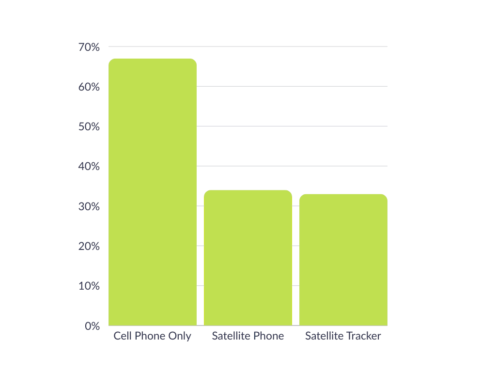
We asked 138 aviators who variously pilot helicopters (30%), gliders (18%), light aircraft (43%), cargo aircraft (25%) or military aircraft (15%) what, if anything, they were using to track their flights.
67% of respondents said they utilized the GPS on their cell phone; 34% had a satellite phone, and 33% had a dedicated satellite tracking device for this purpose (respondents were allowed to pick more than one answer).
While this didn’t come as a huge surprise, there are drawbacks of relying on cell phones. Coverage can be spotty, due to both the altitude and the remote locations visited, and also due to weather conditions. Cell phone service can be negatively affected by storms, wind, rain and even simply cloud cover (source).
Satellite phones are generally less affected by weather, and don’t suffer from coverage issues; they are, however, designed primarily for voice communication, and have none of the specialized features that pilots can benefit from with a dedicated aviation tracking solution.
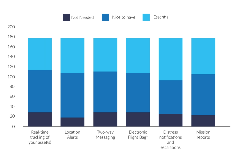
We asked the same group what they valued most in a tracking solution, and, aggregating ‘essential’ and ‘nice to have’, the results were:
- 91% – Location alerts (moving in and out of geofences, stop/start etc.)
- 88% – Mission reports (e.g. mission ID, asset details, route, crew, cargo etc.)
- 87% – Real-time tracking
- 86% – Distress notifications and escalations
- 85% – Two-way messaging
- 83% – Electronic flight bag*
So there is widespread consensus of the value of aviation tracking, but as seen above, only a third of respondents had a dedicated solution for this.
*Advanced messaging including transmission of flight manifest, weight, balance etc.
Why Dedicated Satellite Tracking Devices Excel
Dedicated satellite tracking devices, like the RockAIR, are purpose-built for aviation. Here’s what sets them apart:

Aviation-Specific Features
Altitude Recording: Provides critical data unique to aviation, unlike general-purpose devices
Emergency Response: Distress notifications and escalation processes to ensure swift action when every second counts
Location Alerts: Track movement in and out of geofenced areas or detect when a plane has stopped unexpectedly.

Reliability in Critical Moments
Real Time Tracking: Enables precise monitoring of flight paths, crucial for safety and coordination
Mission Reports: Record mission details such as route, crew, and cargo – helpful for operational efficiency
Two Way Messaging: Communicate instantly, even in areas with no cell coverage.

Designed to Last
Long Battery Life: Far exceeds that of cell phones or satellite phones, ensuring uninterrupted service
Durability: Built to withstand extreme conditions, including potential crashes, ensuring operability when it’s needed most.
A Real Life Lifesaving Story
The value of dedicated tracking devices isn’t theoretical; it’s proven. British pilot Sam Rutherford was flying in the Canadian wilderness when a crash left him stranded in freezing temperatures. Despite the dire situation, he managed to send a location-based message using his RockSTAR device. This timely communication enabled rescuers to locate and save him.
Without a dedicated satellite tracking device, Sam’s story might have ended very differently.
Key Use Cases in Small Aviation
- Flight schools: For flight schools, safety is paramount. Dedicated tracking devices allow instructors to monitor student pilots in real time, providing peace of mind and a critical safety net during training flights.
- Tourist flights: Scenic flights often traverse remote or rugged terrain. Real-time tracking and emergency features not only protect pilots but also reassure passengers of their safety.
- Small private fleets: Fleet operators benefit from improved efficiency and safety with mission reports, real-time tracking, and emergency response capabilities, ensuring that every flight runs smoothly.
Why Not Cell Phones or Satellite Phones?
While cell phones and satellite phones play a role in communication, they fall short in critical ways:
| Cell Phones | Satellite Phones | Satellite Tracking Devices | |
|---|---|---|---|
| Altitude Recording | |||
| Real Time Tracking | |||
| Distress Notifications | |||
| Battery Life | Low | Medium | High |
| Durability | Low | Medium | High |
Dedicated satellite tracking devices stand out as the only option that checks every box for aviation safety and reliability.
Flying with a dedicated satellite tracking device is more than a practical choice; it’s a lifesaving decision. From real time tracking to emergency response, these devices are purpose-built to meet the demands of small aviation.
Can we help?
Don’t leave safety up in the air. Discover the RockSTAR, RockAIR, and other Ground Control solutions to ensure your operations are as safe and efficient as possible.
Contact us by completing the form, or emailing hello@groundcontrol.com; we’ll respond to your inquiry within one working day.
RockAIR Dual Mode Tracking
Using a locally sourced cellular SIM card, or global cellular SIM provided by us, that’s loaded with cellular data, you now have the option of sending tracking reports once every 15 seconds, whenever you’re operating in cell range. The best part? There’re no additional charges for these faster reports.
Traditionally, when you purchase a bundle of credits from us to operate your tracking device, every single position report will use one credit. Now, with the option of cellular tracking, these messages won’t diminish your credit pool – instead, these cellular positions are free. You can even have your RockAIR send these cellular position reports faster than satellite ones to make sure you don’t burn through your credits too quickly.
Beyond the obvious cost savings, this is also a very useful safety feature. With the incredible cellular coverage the world’s now experiencing, search areas for aircraft using cellular tracking will now drastically decrease. By using the power of dual sat/cell tracking, you get complete peace of mind regardless of the location you’re flying in.
For example, if you’re flying at 100 knots using a satellite-only device to transmit at a typical two-minute interval, your potential search area is roughly 116 sqkm (72sqm) if something were to happen. However, if you were using a dual mode device, such as a RockAIR, and you were reporting within cellular range at 15 seconds, the potential search area is significantly reduced to a very small 1.9sqkm (1.18sqm).
The RockAIR intuitively changes between satellite and cellular modes as well. If the unit is struggling to retrieve a cellular signal from its GSM antenna, then it will stop trying to send via cell and will switch to satellite tracking – seamlessly. There’ll be no downtime during this switch.
Dual mode tracking is incredibly easy to set up as well:
1. Open up RockCONNECT on your smartphone or tablet.
2. Select the RockAIR you’d like to connect with, assuming it’s turned on.
3. Select ‘Configure’ then type in ‘1234’ if prompted for a pin.
4. Select ‘Tracking > Satellite Context’ and change the ‘Transmit Frequency’ to your preferred satellite tracking rate.
5. Select ‘Tracking > Cellular Context’ and change the ‘Transmit Frequency’ to your preferred cellular tracking rate.
And that’s it. You’re ready to send tracking reports on either cellular or satellite.
RockAIR Approved by United States Fire Service
Via our aviation partner TracPlus USA Inc, we’re pleased to announce that the RockAIR flight tracker has been approved by the United States Fire Service (USFS) for use on airborne fire-fighting operations, effective immediately.
The RockAIR brings satellite and cellular tracking together in a portable carry-on, carry-off form factor at a much lower cost than traditional dual-mode solutions.
Tracplus’ chief innovation officer, Chris Hinch, said: “We’re absolutely delighted to bring the revolutionary capabilities and affordability of the RockAIR to the US firefighting market. With nearly ten years of global customer experience and insights in airborne firefighting built into the RockAIR, USFS’s approval of the RockAIR is a hugely satisfying validation of our technology and recognition of our commitment to our customers operating in this critical market.”
While tracking systems for light aircraft already exist, Ground Control has introduced a wealth of new features designed to bring extra functionality and safety through the RockAIR system. For starters, RockAIR is the only dashboard-mounted tracking system to offer dual-mode functionality over satcom and cellular networks. The solution provides lower-cost GSM-based tracking when in cellular range, and reliable failover to an Iridium satellite when outside of built-up areas.
Whether the aircraft is working over a city or is in the middle of the Sahara, GPS coordinates will be automatically transmitted using whichever network is available and most cost-effective. This also provides an extra layer of safety and security not available in existing systems.
Enhancing safety even further, RockAIR is the only carry-on tracking system for light aircraft to feature an integrated back-up battery. The battery will automatically take over should the 9-30V DC or Micro USB power be interrupted. While this feature is vital for emergencies, it can also provide a level of security against theft or unauthorised use of an aircraft.
RockAIR is CE, IC, FCC, and DO160 certified, and at 119 x 100 x 25mm/210g, it’s easy to carry on board and attach to the included dashboard quick-release clip. It features its own built-in antenna but can also work with an external antenna, allowing complete flexibility of installation location.
In action, RockAIR can automatically transmit a GPS position as often as every 15 seconds or as infrequently as once every 24 hours, all easily configured by the user. The unit also allows tracking profiles to be setup to enable faster rates if the integrated alert button has been pressed, if external power is applied, or if cellular data is being used rather than satellite. RockAIR also features a ‘Watch Me’ feature, accessible via the keypad, which informs the provider that more active monitoring is required for a period of time.
Get in touch
We have over 20 years’ experience delivering satellite-enabled asset tracking solutions to aviators worldwide.
We’re proud to design and build our own hardware, and we work with other leading manufacturers and airtime providers to ensure that all of our customers get the best solution for their needs.
Just complete the form and we’ll respond with impartial, expert advice.
New Tracking and IoT System Touches Down for Vehicle Fleet Owners
Ground Control brings its innovative RockAIR tracking system back down to earth by officially making it available for land-based applications. The move is a result of high levels of interest in RockAIR’s low-cost, dual-mode communication and feature-packed approach to tracking and safety, already enjoyed by land vehicle fleet owners and operators in the military, charity, and commercial organisations.
With RockAIR, Rock Seven (now trading as Ground Control) initially delivered a ‘carry-on’ cockpit-mounted tracking system for helicopters and light aircraft that not only provided precise location reporting globally, it also introduced new internet of things (IoT) functionality that allowed pilots to send and receive messages and data over the internet. This unique feature-set also has the power to support safety and operational efficiency for diverse users on land, especially for vehicles operated by aid agencies and the military that may be travelling in potentially risky environments.
At its core, RockAIR provides regular GPS location reports from anywhere in the world over the Iridium satellite network or GSM networks at user-defined intervals, ensuring fleet managers know the whereabouts of their assets and people at all times. The dual satellite/mobile functionality provides lower-cost GSM-based tracking when in cellular range, and reliable failover to an Iridium satellite when outside of built-up areas. GPS coordinates are automatically transmitted using whichever network is available and most cost-effective, providing an extra layer of safety and security not available in single channel systems.
RockAIR
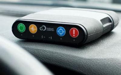
The RockAIR is a global tracking and messaging device designed for use on the dashboard of light aircraft, rotorcraft, and land-based vehicles.
It has built-in LTE Narrowband, which allows it to use terrestrial mobile phone networks when possible, automatically switching to the global Iridium satellite network when LTE Narrowband is not available.
Building on its dual mode functionality, RockAIR offers new features designed to improve safety for vehicles operating in unfamiliar or dangerous locales. It can automatically transmit a GPS position as often as every 15 seconds or as infrequently as once every 24 hours, all easily configured by the user.
It also allows tracking profiles to be setup to enable faster rates if the integrated alert button has been pressed, if external power is applied (e.g., vehicle ignition), or if cellular data is being used rather than satellite. RockAIR also features a ‘Watch Me’ feature, accessible via the keypad, which informs the provider that more active monitoring is required for a period of time, enabling personnel in vehicles to react to situations that may escalate quickly, for example, during civil unrest or active combat.
While delivering precise tracking is RockAIR’s primary application, Ground Control has integrated extra functionality that takes advantage of the always-on connection the system keeps to the Iridium satellite and GSM networks.
Users can send and receive low-cost short emails and text messages using the free (iOS/Android) companion app over Bluetooth, ensuring that regardless of location, they can report back to base. RockAIR is also a true IoT device. It features a RS-232 port, which can be used for machine-to-machine data, enabling users to connect sensors and computing platforms to the internet. A Bluetooth API makes it easy for organisations to create their own apps that make use of the highly reliable connectivity RockAIR provides to benefit their specific operations.
Nick Farrell, director at Rock Seven (now trading as Ground Control), said: “While NGO and military organisations face completely different challenges from the general aviation sector, RockAIR’s tracking and data functionality is just as effective for improving safety and logistics on the dashboard of an SUV or troop carrier as it is in the cockpit of a helicopter or light aircraft. The interest we’ve received from organisations looking at land applications for RockAIR is huge, and we encourage fleet owners to get in touch to discuss how the system can help them to monitor and control their vehicles more effectively and for a lower cost.”
Get in touch
We have over 20 years’ experience delivering satellite-enabled asset tracking solutions to aviators worldwide.
We’re proud to design and build our own hardware, and we work with other leading manufacturers and airtime providers to ensure that all of our customers get the best solution for their needs.
Just complete the form and we’ll respond with impartial, expert advice.