Industry: Fisheries

How RockFLEET Helps French Fishing Fleets Meet 2026 VMS Rules
New satellite vessel monitoring requirements for France’s coastal fishing fleet
In 2026, France introduced mandatory Vessel Monitoring System (VMS) requirements for professional fishing vessels under 12 metres, extending satellite monitoring across almost the entire commercial fishing fleet.
The change, driven by reforms to the European Union’s Common Fisheries Policy (CFP) and France’s Order of 24 February 2026, represented one of the most significant regulatory changes for the country’s coastal fishing industry in recent years.
With around 86% of France’s professional fishing vessels measuring less than 12 meters, thousands of operators needed to equip their vessels with approved tracking technology capable of securely transmitting vessel position and activity data to fisheries authorities.
The Challenge
Until the legislation was enacted, mandatory VMS tracking in Europe applied only to fishing vessels over 12 meters. Beginning in 2026, the requirement will be progressively extended to smaller professional fishing vessels operating in coastal waters, including many artisanal fishing businesses that use passive fishing gear such as nets, longlines and pots.
The legislation has been introduced to improve the traceability of fishing activities, strengthen fisheries control across Europe and support the sustainable management of marine resources. By extending VMS across the entire professional fleet, European and French authorities aimed to create a more consistent and transparent approach to fisheries monitoring while providing scientists with higher quality data to better understand fish stocks and fishing activity.
For many vessel owners, the challenge was finding a tracking solution that not only complied with the new regulations, but also operated reliably in both coastal and offshore environments without disrupting day to day fishing operations.
The Solution
Ground Control’s RockFLEET tracking device provides a dependable vessel monitoring solution designed specifically for the demands of the maritime industry. Drawing on our parent company CLS’s extensive expertise in satellite technology and fisheries monitoring, RockFLEET enables operators to meet the latest French and European VMS requirements through secure, continuous reporting.
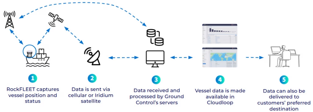
The system automatically transmits vessel position data while intelligently switching between cellular networks in coastal waters and the Iridium satellite network when further out to sea. This hybrid approach ensures uninterrupted connectivity throughout every voyage without requiring manual intervention from the crew.
All transmitted data is protected using AES-256 encryption, while advanced geofencing, automated alerts and electronic catch reporting integration help operators meet regulatory obligations with confidence. RockFLEET is also compatible with fisheries monitoring centres and existing regulatory systems, making deployment straightforward for vessel owners and authorities alike.

Supporting Sustainable Fisheries
The expansion of VMS across France’s coastal fishing fleet forms part of a broader European initiative to improve transparency, traceability and the long-term sustainability of commercial fishing. By increasing the quality and coverage of satellite monitoring data, fisheries authorities can verify compliance with regulated fishing areas, strengthen efforts to combat illegal fishing, and improve the scientific assessment of fish stocks.
For vessel owners, this transition is an opportunity to adopt modern digital technology that improves operational efficiency, enhances safety and contributes to the sustainable management of marine resources. With reliable hybrid connectivity and trusted satellite communications, RockFLEET helps make this transition both straightforward and future-ready.
The Results
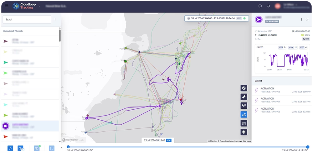
While RockFLEET enables operators to comply with the new VMS regulations, its benefits extend well beyond regulatory compliance. Continuous vessel visibility provides fishing businesses with greater operational awareness while improving crew safety and vessel fleet management. At the same time, fisheries authorities receive secure, reliable vessel position reports that support more effective monitoring and enforcement.
By simplifying compliance and delivering reliable connectivity wherever vessels operate, RockFLEET supports the digital transformation of France’s small-scale fishing sector. Operators gain a modern tracking solution that not only satisfies today’s legal requirements but also prepares them for future developments in fisheries management and digital reporting.
Paul Steinbach, Sales Manager, France & Overseas Territories, CLS Group, says:
“With the RockFLEET device, we have a reliable and easy-to-use solution that meets the new regulatory requirements while giving us greater visibility of vessel operations.”
Looking Ahead
As VMS requirements continue to expand across Europe’s fishing fleets, reliable satellite connectivity will become an increasingly important part of everyday fishing operations. RockFLEET gives operators the confidence that they can remain compliant while benefiting from a robust vessel monitoring solution that delivers continuous tracking, secure communications, and dependable performance in even the most challenging maritime environments.
Whether operating close to shore or far offshore, fishing businesses can rely on RockFLEET to support compliance today while providing the connectivity needed for the future of digital fisheries management.
Want to Find Out More?
If you are looking for a reliable, secure, and easy-to-use vessel tracking device, RockFLEET is a great option. It’s perfect for a variety of maritime applications, and backed by a team of experts who are dedicated to providing you with the best possible support.
Start a chat with our team today and discover how RockFLEET can enhance your marine operations. Complete our online form, or if you prefer to speak to someone directly, call us on +44 (0) 1452 751940 (Europe, Asia, Africa) or +1.805.783.4600 (North and South America). We’re standing by to help.
Blue Ocean Gear’s mission is to bridge the gap between commercial ocean fishers and marine conservationists. Their satellite-connected Smart Buoy enables commercial ocean fishermen to efficiently track the location of their equipment and reduce the number of damaged nets and lines lost to the open ocean where they pose a threat to marine animals.
Blue Ocean Gear partnered with Ground Control to install Iridium 9603 modems to their Smart Buoys to transmit telemetry and location data via satellite, which is then integrated into the Blue Ocean Gear app and Timezero, a software commonly used by commercial fishing vessels.
This enables fishers to know when they have a catch ready for collection, to locate their catches quickly and reduce the amount of fuel required to reach them. They can also track valuable lost equipment, which in turn prevents the risk of entanglement to ocean animals from damaged fishing equipment floating free.
Fangstr is a complete solution for professional fishing fleets who need to provide catch logs and tracking information – usually for regulatory purposes. Utilizing Ground Control’s RockFLEET hardware, the team at Fangstr have created a powerful software and reporting app that captures and transmits departure points (DEP), catch reports (DCA) and port calls (POR).
This information can be automatically transmitted to the regulatory authority, formatted correctly for seamless integration with their systems. The location tracking and catch reporting is also very useful for fishing fleet managers, so you can see in real-time what’s happening at sea.
The ruggedized and waterproof RockFLEET transmits location and telemetry data via both cellular and satellite, using least-cost routing, an important consideration in this instance.
Based in Tromsø, Norway, GoFish delivers digital catch reporting for tourist fisheries. GoFish Start is their ‘beginner’ solution, offering catch registration, automatic reporting, digital guest registration, customs documentation, boat booking, ‘no-go’ zones and emergency alerts. GoFish Pro adds real-time tracking of boats, and support for affiliated systems: AIS, Guard Systems and Trackunit.
In countries where legislation requires that fishing vessels report their associated catch, zero catch or released fish – such as Norway – GoFish is an essential app to ensure compliance and protect marine resources.
The team behind GoFish – Dualog – first developed the commercial catch reporting app Fangstr, and have used that expertise to deliver GoFish. Ground Control provides them with both tracking and communication capabilities; the robust and reliable RockFLEET device transmits their data using, in this instance, cellular only, as there is good coverage in the areas where tourists are encouraged to fish.
Pivotel supports fisheries regulators and fishermen in Australia and New Zealand with the mass deployment of mandated VMS systems and remote satellite communications for their marine vessels. Their solution is used to monitor quota in near real-time; monitor compliance with area and seasonal closures; supply evidence for investigations where needed; validate logbook entries on when/where fishing took place, and estimate fish stock levels.
Leveraging Pivotel’s online tracking portal, Tracertrak, the fixed mount RockFLEET devices provide real-time tracking and historical location information to the VMS (Vessel Monitoring System) licence holder to ensure compliance with government regulations.
The RockFLEET devices are waterproof, ruggedized and easy to install on vessels, making them perfect for remote installations and coping with tough marine conditions. Pivotel’s platform also supports data provided by the RockSTAR, our handheld, portable tracking and IoT solution which is ideal for river fishing and shellfish divers.