Topic: First Responders
How Satellite Technology Can Help First Responders With Disaster Relief
Over the last 20 years, there has been a staggering rise in the number of extreme weather events. According to a recent report by the United Nations, between 2000 and 2019, there have been 7,348 major natural disasters worldwide. Tragically, these have led to the deaths of 1.23 million people and resulted in an astounding $2.97 trillion in global economic losses.
With natural disasters becoming more frequent and hurricane season already in progress, it’s vital First Responders look at how they can utilize technology to best aid emergency response efforts. Boasting ubiquitous coverage, satellite technology has been used to support disaster relief efforts since the 1970s.
How First Responders can leverage satellite technology
Satellite imaging and analysis has and continues to develop, delivering crucial, accurate and real-time information to teams on the ground. As an example, California National Guard have been using satellite technology since 2018, to help them fight wildfires.
Satellites equipped with sensors are able to pick up hot spots via infrared radiation detection, effectively enabling them to see heat. This helps the state’s National Guard to detect and map fires, as well as assess the damage they cause. When a blaze is detected, a heads up is sent to one of two California Department of Forestry and Fire Protection-U.S. Forest Service regional operations centers in the state. From there, analysts use the information provided to “very rapidly determine whether or not the fires are campfires or car fires or a fire that could indeed become a very dangerous wildfire” – explains California Adjutant General Maj. Gen. David Baldwin.
However, aerial imaging is not the only way satellite technology can enable a more effective, safer, emergency response. Although terrestrial networks are built to be resilient, outages due to hurricanes, earthquakes, floods and other severe weather is common. With many natural disasters rendering terrestrial infrastructure inoperable, increasingly, redundant communications are becoming an integral part of disaster relief and management.
First Responder communications
For First Responders, the importance of communication can never be underestimated. Ultimately, response disciplines must connect and work together, to ensure the best outcomes during disaster recovery and maintaining public safety more generally.
However, it was reported by the government that first responders in the US rely on more than 10,000 separate, incompatible, and often proprietary radio networks to communicate with each other during emergencies. Given the significant consequences of not being able to properly disseminate information during an emergency, this is concerning.
Critical SATCOM for First Responders
Today, satellite communications (satcom) play an essential role in the global telecommunications system. Approximately 2,000 artificial satellites orbiting Earth relay signals carrying voice, video and data to and from, one or many locations worldwide. While many may be familiar with the benefits of push-to-talk devices and satellite phones, VSAT and Go-anywhere Pro (previously known as BGAN) terminals can also be particularly effective during disaster management.
Following the mass destruction of hurricanes Irma and Maria in 2017, 900 VSAT terminals were deployed at sites around the affected region and critical locations including San Juan Airport. VSAT terminals can enable:
- Data and broadband connectivity
- Voice communications
- High throughput data
- Drone video backhaul
- Red Phone Emergency Responder Voice Network access
As such, they can prove invaluable during disaster relief. VSAT and Go-anywhere Pro terminals not only deliver rapidly deployable connectivity, enabling effective response coordination, they also deliver instant infrastructure. First Responders and recovery teams can communicate with each other and relevant control center(s), analyze the situation and make adjustments.
Connectivity also empowers teams to better support continuity throughout the recovery process. For example, enabling point of sale (POS) credit and debit card authorizations and inventory management, meaning individuals can purchase recovery essentials including food and fuel.
With over 20 years experience enabling critical safety across the globe, Ground Control has been a trusted name in Emergency Responder satcom since 2002.
VSAT and Go-anywhere Pro solutions for Emergency Responders
Toughsat Flyaway Mobile Hotspot
The Toughsat Flyaway is often used by emergency services that need a quick and portable VSAT antenna for both high-speed internet and VoIP phone services for on-site personnel.
The Toughsat Flyaway satellite system delivers Ground Control’s powerful Toughsat XP satellite solution, in an easily transportable set-up. The multi-functional stabilization brackets work for both ground mounting and roof-rack “fly-and-drive” mounting – even on rental vehicles. With an auto-pointing antenna, robust, high-speed internet and redundant communications can be quickly deployed at any location.
We’re proud to say our Toughsat solutions are trusted by hundreds of Urban Search and Rescue agencies, Federal Police, State, County and City Law Enforcement and Fire Departments throughout the United States today.
MCD-4800 “The Football”
Similarly, the MCD-4800 “Mobile Communications Device”, also known as “The Football”, is also capable of providing redundant communications and high-speed internet, anywhere in the world. The auto-pointing Go-anywhere Pro satellite terminal requires no user training to operate and can be used in extreme weather conditions.
Users simply place the weatherproof case on the ground or any surface with a clear view of the sky, turn it on and close the lid. Within a minute the MCD-4800 becomes a powerful WiFi hotspot accessible by any wireless device within a 100 meter range for up to 5 hours on internal battery power.
This auto-pointing solution uses the high performance Hughes 9450TW in-motion Go-anywhere Pro terminal integrated with our proprietary mobile electronics for a ruggedized, self-contained, user-friendly, global communications link.
Ground Control’s emergency communications satellite equipment meets or complies with all SAFECOM requirements, for emergency interoperable communication equipment.
Ultimately, satellite technology helps promote First Responder safety and efficiency, during disaster recovery. The technology has already been used worldwide to monitor events, improve responses and drive resilience post-disaster, providing infrastructure support.
If you’d like to get in touch to discuss potential satellite solutions for your organization or agency, simply email sales@groundcontrol.com.
Get in touch
With over 20 years experience facilitating emergency preparedness and response across the globe, we understand that in a crisis, every second counts. We’re constantly evolving and adapting our Public Safety offer and systems to best support teams on the ground. Which is just part of the reason Ground Control has been a trusted name in Emergency Responder satcom since 2002.
Whatever your communication or connectivity needs, we can help.
Could your Business Achieve More with Better Connectivity?
In the world of industrial IoT, cellular connectivity is the default means of transferring sensor data back to your SCADA system. But what happens if the location your sensors are in is too remote to reliably connect to cellular? Or what if your sensors are on the move, dipping in and out of cellular range? In these scenarios, satellite-enabled IoT is an obvious choice, but has long been viewed as too expensive, too complicated, too fragile, or even not secure enough.
In this webinar, recorded in September 2021, Solutions Architect Matthew Ellison and Channel Partner Manager Rory Ashley seek to dismantle these perceptions, and give real-life examples of where the extra data provided by satellite IoT connectivity has materially improved outcomes – from smart farming to disaster management, environmental monitoring to renewable energy production.
Connectivity Challenges
Terrestrial networks only cover 15% of the Earth’s surface, and focus on populated areas. This leaves a number of businesses unable to reach their assets remotely, and having instead to resort to manpower – with the time delays and additional costs presented by that solution. In these scenarios, satellite connectivity is an obvious choice.
Further, the number one challenge The IoT Magazine stated that IoT faced was cybersecurity, and the risk of hacking. Satellite has a huge advantage over cellular here, as, if needed, an entirely private satellite network can be created with no reliance on, or exposure to, public networks at all.
Satellite vs Cellular from a Cost Perspective
Satellite is not as low cost as cellular, but it is moving in the right direction. Greater competition, better technology, and diversification of offerings has seen the wholesale price of high-throughput satellite tumble in recent years, and it’s our view that prices will continue to lower, as the established players – Inmarsat and Iridium, for example – come up against well funded new entrants like Elon Musk’s Starlink, and Amazon’s Kuiper satellite offerings.
That said, it’s improbable that satellite will replace cellular, as it is likely to always remain a little more expensive; so the applications for satellite IoT are, not unexpectedly, those where cellular networks are unavailable, such as ocean data buoys or remote farms, or where the asset is moving in and out of terrestrial connectivity – such as transport and cargo ships.
Make sure to watch the webinar to see great examples of satellite connectivity in action – and if you have any questions, we’re here to help.
Get in touch
We’ve implemented satellite IoT infrastructure for decades, and there’s very rarely been an obstruction issue we couldn’t overcome with a bit of knowledge and ingenuity.
We’d be happy to talk to you about your project and offer impartial advice on the best antenna and satellite service for your particular requirements. Call or email us, or complete the form.
RockSTAR Used in Iridium Certus Demo
British search and rescue charity SARAID hosted an immersive, natural disaster search and rescue live demonstration day in association with Ground Control and Iridium. Using RockSTAR devices to track team members, contributors were able to showcase how the Iridium Certus platform can work in the field.
The demonstration day was held at the Rig 5 incident ground at The Fire Service College. The unique 300-acre venue can be found at Moreton-in-Marsh in the United Kingdom. It has an impressive collapsed structure, vast rubble pile, and destabilized floors and walls. The enormous grounds and specialist facilities are the perfect environment for identifying where tracking systems would be needed most.
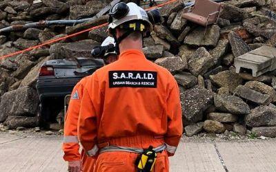
The main purpose of the demonstration was to show how the Iridium Certus platform can benefit a number of sectors, from military to search and rescue and utility companies. The advanced multi-service platform delivers a reliable connection for voice and data services, including telephony, satellite internet, land mobile radio, and location-based applications. All of which can now all be made possible by the upgraded Iridium constellation.
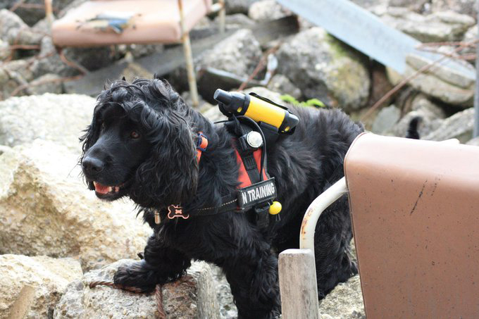
Rock Seven (now trading as Ground Control)’s RockSTAR device was given to each search and rescue (SAR) team member. Certus allowed the people on the ground to get a secure, strong internet connection, allowing them to tap into the RockSTAR tracking applications online. Each RockSTAR transmitted every minute with 15-second updates, giving the team leader a view on where their SAR team members were in the field at all times.
Even their rescue dog in training had RockSTAR strapped to its body to track its position during the exercise. This shows the versatility of our devices and how almost anything that moves can be tracked if it’s big enough to carry the product.
Rock Seven (now trading as Ground Control) CEO, Nick Farrell, bore witness to the demonstration. He said: “Seeing SARAID in action was so impressive. We rarely think about the brave men and women, all volunteers, who deploy into disaster zones to help those in need. They work for weeks at a time, helping to find and rescue people trapped in destroyed buildings, risking their own lives in the process – incredibly hard work, with relentless determination and total selflessness.
Anything we can do as a business to help provide better connectivity and situational awareness for SARAID and other similar organizations will hopefully translate into more lives saved.”
Building Hot Shot Fire Prevention with the RockBLOCK
James Dziadulewicz B.S. Eng. Mech & electronics engineer has built a one of a kind home in Malibu, California. His incredible home is situated on 10 acres of land in a high fire risk zone. Knowing that his home is susceptible to bushfires, James wanted to install a system that would protect his home from any impending danger. As a result of the potential threat of fires, he created the Hot Shot system – an automated, off the grid fire prevention system.
He installed a solar system with a backup generator and, using their own water supply, trenched irrigation lines and setup 12 high-pressure sprinklers around the perimeter of the home and their powerhouse trailer. He connected it all up to a 2.0 HP irrigation pump and electronic solenoid. He also used Arduino components to take transmitted messages and use them to turn the pump and solenoid on and off at will.
Knowing that he lived in an area that could potentially be completely cut off from cell phone reception and power if the towers were disabled during a fire, James decided that he needed a 100% reliable communication system so that he could receive and send messages to enable his system. He discovered the RockBLOCK and, realising it ran off of the Iridium Satellite Network, installed one to be used as the transmitter. Paired with an external helical antenna, this guaranteed that any messages sent to or from the RockBLOCK would be transmitted reliably.
RockBLOCK 9603
The smallest and lightest version in our RockBLOCK family, the RockBLOCK 9603 is targeted primarily at systems integrators and product developers where space inside your enclosure is at a premium. RockBLOCKs can send and receive short messages from anywhere on Earth with a view of the sky.
With an app created by his friend, Matthew Jenks B.S. Eng. software & M.S. Eng. electrical engineer, James was able to activate the system 54 miles away from his home using his phone, when he received from the sensors attached to the system that the fire was getting closer. He activated the system 35 minutes before the fires hit the area. This was more than enough time for the high-pressure sprinklers to activate and douse his home and the surrounding area, effectively making the area impervious to the fires. His home was left completely unscathed.
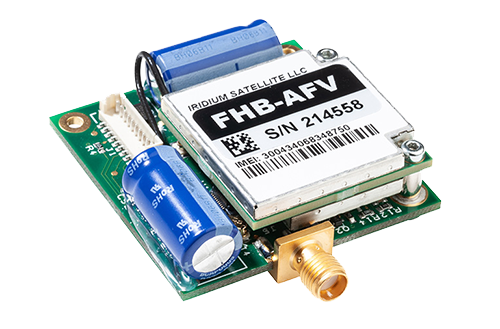
While the RockBLOCK is small, it’s a vital part of the system. It worked so well it is now patent pending, and we’re thrilled that we played a part in saving James’ beautiful home. We’re hoping that this system will start to roll out over areas with high fire risk, with one large home in Thousand Oaks, California, already signing up for one.
Can we help you?
Get in touch with us and find out if the RockBLOCK 9603 is the right device for your needs. Either complete our online form, or call us to be connected directly with one of our expert team. Call +44 (0) 1452 751940 (Europe, Asia, Africa, Oceania) or +1.805.783.4600 (North and South America).
With over 20 years experience in satellite tracking we have the knowledge and experience to ensure you are equipped with everything you need to make the right choice.
RockAIR Approved by United States Fire Service
Via our aviation partner TracPlus USA Inc, we’re pleased to announce that the RockAIR flight tracker has been approved by the United States Fire Service (USFS) for use on airborne fire-fighting operations, effective immediately.
The RockAIR brings satellite and cellular tracking together in a portable carry-on, carry-off form factor at a much lower cost than traditional dual-mode solutions.
Tracplus’ chief innovation officer, Chris Hinch, said: “We’re absolutely delighted to bring the revolutionary capabilities and affordability of the RockAIR to the US firefighting market. With nearly ten years of global customer experience and insights in airborne firefighting built into the RockAIR, USFS’s approval of the RockAIR is a hugely satisfying validation of our technology and recognition of our commitment to our customers operating in this critical market.”
While tracking systems for light aircraft already exist, Ground Control has introduced a wealth of new features designed to bring extra functionality and safety through the RockAIR system. For starters, RockAIR is the only dashboard-mounted tracking system to offer dual-mode functionality over satcom and cellular networks. The solution provides lower-cost GSM-based tracking when in cellular range, and reliable failover to an Iridium satellite when outside of built-up areas.
Whether the aircraft is working over a city or is in the middle of the Sahara, GPS coordinates will be automatically transmitted using whichever network is available and most cost-effective. This also provides an extra layer of safety and security not available in existing systems.
Enhancing safety even further, RockAIR is the only carry-on tracking system for light aircraft to feature an integrated back-up battery. The battery will automatically take over should the 9-30V DC or Micro USB power be interrupted. While this feature is vital for emergencies, it can also provide a level of security against theft or unauthorised use of an aircraft.
RockAIR is CE, IC, FCC, and DO160 certified, and at 119 x 100 x 25mm/210g, it’s easy to carry on board and attach to the included dashboard quick-release clip. It features its own built-in antenna but can also work with an external antenna, allowing complete flexibility of installation location.
In action, RockAIR can automatically transmit a GPS position as often as every 15 seconds or as infrequently as once every 24 hours, all easily configured by the user. The unit also allows tracking profiles to be setup to enable faster rates if the integrated alert button has been pressed, if external power is applied, or if cellular data is being used rather than satellite. RockAIR also features a ‘Watch Me’ feature, accessible via the keypad, which informs the provider that more active monitoring is required for a period of time.
Get in touch
We have over 20 years’ experience delivering satellite-enabled asset tracking solutions to aviators worldwide.
We’re proud to design and build our own hardware, and we work with other leading manufacturers and airtime providers to ensure that all of our customers get the best solution for their needs.
Just complete the form and we’ll respond with impartial, expert advice.