Topic: Environmental
Octanis Rover Mission
Operating out of the École Polytechnique Fédérale de Lausanne, Octanis is a 30-member strong not-for-profit student/alumni association focused on enabling rapid prototyping locally. Anyone interested in sciences, engineering, or making can become a member.
It was the need for a low-cost, minimal environmental impact platform for scientific experiments in extremely cold temperatures, that led the association to develop the Octanis Rover.
The rover was designed to be weatherproof, cold-resistant, and lightweight, while robust enough to complete a multi-month mission autonomously. From November 2016 to January 2017, Octanis successfully field-tested the rover in Antarctica on a research mission to create a map of the snow surface using the rover’s low-cost laser scanner.
Using differential GPS (dGPS), stereo cameras, and LIDAR, an operator in the field chose waypoints for the rover’s goal-to-goal navigation. At the same time, its internal and external sensors would regularly gather and transmit telemetry back to a nearby field base station via LoRa radio.
At the station, the mission’s waypoints and sensor telemetry were transmitted via RockBLOCK back to Switzerland, allowing the research team to see how the Octanis rover was operating and to ascertain whether its sensors were producing good data.
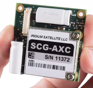
RockBLOCK 9603
RockBLOCK 9603 is targeted primarily at systems integrators and product developers where space inside your enclosure is at a premium.
RockBLOCKs can send and receive short messages from anywhere on Earth with a view of the sky.
All Octanis software and hardware has been specifically chosen to adhere to the principles of the open source movement, and the RockBLOCK is no exception. The publicly available Rock Seven (now trading as Ground Control) API allows users to deliver messages from RockBLOCKs directly to their own application’s web service or e-mail, and to send messages or commands back to RockBLOCKs in the field.
The HAPP Project
Thanks to advancements in IT and DIY fabrication, missions reserved for national space agencies just a decade ago are becoming increasingly accessible to hobbyists. Cue the High Altitude Photography Platform (HAPP), created by Christopher Couch and James Mayes.
The two engineers designed and built the HAPP, which is comprised of a jet-stabilized aircraft resembling the iconic three-man Apollo re-entry vehicle: a balloon system designed to take the aircraft to its 30km apogee and all the peripheral equipment and electronics that made that project successful. Though not the first high-altitude photography project, the HAPP is the first to capture stabilized 360-degree video.
Even more amazing was the project’s focus on DIY: over 80% of the 22 months for development were dedicated to creating tools and methods rather than actually producing flight hardware. The result is a project that can be replicated by hobbyists using locally sourced parts.
The HAPP can drift as much as 100km during each mission, so it was important to keep track of the lander and provide flight data to air traffic control. The RockBLOCK 9603 was vital in sending telemetry and system sensor data from the Arduino-based flight control computer at an altitude of up to 22km on the maiden flight, mission HAPP-M1.
While the power supply was in a temperature-controlled enclosure, the U-Blox board and PCBs were exposed to the atmosphere for the duration of the mission, experiencing temperatures ranging from +42°C down to -45°C, and pressures from 1atm down to 0.05atm.
The project’s creators have done a great job in documenting the project build and sharing the valuable knowledge they’ve gained.
The Bespin Project
In the spring of 2017, an international team of students from Luleå University of Technology in Sweden gathered together to brainstorm a REXUS/BEXUS program idea. The European program supports scientific and technological experiments on research rockets and balloons, sending two of each into space every year.
After some deliberation by the team, it was a scientific article on the potential of a manned mission to the upper Venusian atmosphere that gave the impetus for the Balloon Ejection Student Prototype INvestigation (BESPIN) Project. Though Venus’s runaway greenhouse effect makes the planet’s surface hot enough to melt lead, at a height of 50km temperature and pressure conditions are very similar to those found on Earth. This makes a balloon-assisted manned mission to Venus highly plausible.
That’s why the BESPIN experiment is made up of two parts – a flotation probe and a descent probe. At apogee (around 80km), both probes are ejected as a single free-falling unit (FFU) from the rocket’s nose-cone. The FFU freefalls until it reaches an altitude of about 5km, when a parachute is deployed on the descent probe.
When the FFU’s velocity has dropped below 7 m/s, a balloon on the flotation probe will inflate. Once it’s fully inflated, the descent and flotation probes will separate. The descent probe will continue parachuting down towards the ground, while the flotation probe uses its fully inflated balloon to attempt a controlled descent.
Following the deployment of the descent probe parachute, the team will be using a RockBLOCK 9603 to communicate housekeeping and positional data to a ground station. Like the rest of the equipment, the RockBLOCK will be undergoing rigorous testing to ascertain its suitability for vibration, shock, and pressure changes associated with the mission.
RockBLOCKs Measuring Glacier Movement
Professor Kirk Martinez and his team from the University of Southampton, UK, are using moving rover units equipped with RockBLOCKs to measure how Icelandic glaciers respond to small-scale changes in temperature and precipitation throughout the year.
Global warming has resulted not just in the melting of glaciers throughout the world, but in their accelerated movement as well. The increased temperatures mean that a larger amount of water is finding its way underneath glaciers, effectively acting as a lubricant and causing glaciers to speed up.
Using differential GPS (dGPS), Professor Martinez can accurately calculate glacier speeds by measuring location differences as small as 2cm. In the past, achieving such spatial resolution in remote locations and over the course of months was financially prohibitive.
But not anymore, thanks to the next generation of low-cost hardware being used in his Ice Tracker project. In previous research, sensor probes were also placed in and under glaciers, collecting data on conditions, pressure, stresses, and subglacial movement.
All of us at Rock Seven (now trading as Ground Control) wish Professor Martinez and his team the very best of luck.
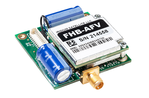
RockBLOCK 9603
The smallest and lightest version in our RockBLOCK family, the RockBLOCK 9603 is targeted primarily at systems integrators and product developers where space inside your enclosure is at a premium.
RockBLOCKs can send and receive short messages from anywhere on Earth with a view of the sky.
Get in touch
Get in touch with us and find out if the RockBLOCK 9603 is the right device for your needs. Either complete our online form, or call us to be connected directly with one of our expert team. Call +44 (0) 1452 751940 (Europe, Asia, Africa, Oceania) or +1.805.783.4600 (North and South America).
With over 20 years experience in satellite tracking we have the knowledge and experience to ensure you are equipped with everything you need to make the right choice.
Balloon-Borne Imaging Telescope
Twinkling stars may be a gift for song writers and romantics, but they’re a bane for cosmologists who need a clear view of the sky to gather important data. Compensating for the many distorting kilometers of the Earth’s atmosphere is usually done by adaptive optics or by placing a telescope in orbit. But both solutions are notoriously expensive and difficult.
An international team of collaborators made up of the University of Toronto Physics and Astronomy Departments, the Dunlap Institute, and the Institute for Aerospace Studies, the Durham University Centre for Advanced Instrumentation, Princeton University, and the Jet Propulsion Laboratory, went for a tried-and-tested solution dating back to the late 1700s – and thus the Balloon-borne Imaging Telescope (aka. SuperBIT) was born.
Floating a 0.5m telescope above 30km (and 99%) of the Earth’s atmosphere required some heavy revising of 300-year-old ballooning technology. An array of precision gyroscopes, motors, and actuators, as well as a custom-built star tracker, were used to achieve advanced image stabilization. The result is crisp one- to five-minute exposures in the near-infrared, red, green, blue, and ultraviolet bands, as well as in broadband.
The SuperBIT can collect several gigabytes of data per night, and relaying it back to Earth is not just complex but expensive. One idea put on the table was to periodically offload the data via radio or microwave from an under-flying plane. The balloon’s remote position over the ocean though would make this logistically difficult.
Paul Clark, head of engineering at Durham CfAI, said: “Our slightly crazy idea is to carry out data drops whenever the balloon passes over land. Imagine a TB flash drive being dropped from the telescope gondola and coming down to the ground on a parachute. The challenge then is to track the data payload as it descends and find it once on the ground. That’s where the Iridium 9603N comes in.”
The SuperBIT beacon that tracks the payload uses a GPS receiver and an altitude/pressure sensor integrated with the Iridium 9603N modem. The beacon design has proved reliable, even at high altitudes where the temperature falls below -50C and the air pressure is very low. Battery chemistry has also been carefully chosen to withstand the extreme conditions. The beacon is robust enough to have been recovered from a tree and a lake.
The team is now getting ready for a third engineering flight from Palestine, Texas, while the main ultra-long-duration balloon flight (ULDB) is scheduled for 2020 in New Zealand. It’s this final mission that will demonstrate the SuperBIT’s capability as a facility-class instrument.
When fully operational, the SuperBIT will study strong and weak gravitational lensing and map out the distribution of dark matter around hundreds of galaxy clusters.
Photos (c) Department of Physics, University of Toronto.
Get in touch
We’ve implemented satellite IoT infrastructure for decades, and there’s very rarely been an obstruction issue we couldn’t overcome with a bit of knowledge and ingenuity.
We’d be happy to talk to you about your project and offer impartial advice on the best antenna and satellite service for your particular requirements. Call or email us, or complete the form.
Transmitting Sensor Data Back from Extremely Remote Locations with Gill Instruments
Ground Control offers users the ability to connect to all Gill meteorological sensors, taking key data on a regular basis and transmitting it over satellites at an affordable price.
Collecting data from extremely remote systems is now becoming commonplace, and there are a number of existing GSM/GPRS services which allow this. However, they assume that there’s some form of mobile network coverage, whereas a lot of extremely remote installations are far from civilization or in areas where there are gaps in the mobile network coverage.
Now, there’s a way to collect data from your remote sensors regardless of where the systems are installed, using the global network of Iridium satellites and the RockFLEET‘s M2M/IoT ability.
Alongside the meteorological data, the RockFLEET unit also transmits position data – particularly useful where installed on buoys or other equipment that may move position either accidentally or by design. By getting regular position reports, you can receive early warnings if your equipment is moving off-station. RockFLEET is designed to provide global tracking and M2M/IoT (machine-to-machine / internet of things) data communication from anywhere in the world.
Capturing Scientific Data from the Arctic and Antarctic
With the growing need to secure new data from remote and inhospitable areas of scientific interest balanced against commercial challenges and tough competition for academic budgets as a background, Ground Control reported an upsurge in its Iridium satellite communication products being used for environmental science applications in both the Arctic and Antarctic.
Several successful deployments have proven the robustness of the company’s RockBLOCK and RockFLEET systems, highlighting their suitability for reducing costs not only in the research sector, but also in commercial industries such as oil & gas and mining.
Ground Control is the manufacturer of the innovative RockBLOCK, a tiny device that can be integrated with most computing platforms to provide global data transmission capabilities even at the Poles. The system is currently being used by a team from the National Institute of Water and Atmospheric Research – New Zealand (NIWA) to measure the effects of storm waves on sea ice. RockBLOCK has been integrated on specially developed wave buoys deployed on to sea ice floes in the Arctic and Antarctic by NIWA. The system transmits GPS position and signal strength data from the buoys every hour, allowing the teams to plot the movement of the ice against wave data.
Project contributor Scott Penrose, software architect at Digital Dimensions, said: “The research is vital as it supports investigation into current environmental changes at the Poles while informing the development of future models. RockBLOCK helps us collect data from our wave buoys using Iridium short burst data, which is the easiest and most cost-effective way, especially considering the low cost of the device itself. Despite this, the system is more than capable of operating in such extreme environments while providing reliable data according to our set schedule.”
Ground Control’s Iridium technology is also being used in the Arctic by the Laboratory for Cryospheric Research, which is dedicated to the monitoring and understanding of the frozen earth including glaciers, ice caps, ice shelves, snow, and sea ice.
Laboratory members are undertaking research across northern Canada, including monitoring glacier changes in Kluane National Park, examining ice shelf and sea ice interactions along northern Ellesmere Island, and measuring glacier and ice cap dynamics across the Canadian Arctic Archipelago. A team from the laboratory is using Ground Control’s RockFLEET product, combined with a solar panel and extra battery pack, to provide long term position monitoring of sea ice in the region.
Nick Farrell, director of Rock Seven (now trading as Ground Control), said: “Operating in such extreme environments can be costly, so research teams are looking at ways to reduce their spend. RockBLOCK and RockFLEET fulfil this need, whilst still providing the reliability of much more expensive systems, in terms of hardware and airtime costs. There’s real potential for technology transfer from research to commercial industries based on these developments. We’re seeing more interest from the oil and gas industry for instance, where data originating at facilities in remote or hazardous locations can inform if an engineer needs to visit or not.”
Designed to work with any platform with a serial or USB port, including Arduino™, Raspberry PI™, and Intel Edison, as well as Windows, Mac, and Linux computers, RockBLOCK is a simple and reliable way to integrate two-way communication into sensor and measurement based research projects. It can send messages of 340 bytes and receive messages of 270 bytes using Iridium short burst data, which offers global, pole-to-pole coverage. At just 76.0 x 51.5 x 19.0mm, the system can be integrated easily into almost any sensor station. The RockFLEET system offers the same communication capabilities as RockBLOCK but comes in a sealed form factor for permanent installation.
Get in touch
We’ve implemented satellite IoT infrastructure for decades, and there’s very rarely been an obstruction issue we couldn’t overcome with a bit of knowledge and ingenuity.
We’d be happy to talk to you about your project and offer impartial advice on the best antenna and satellite service for your particular requirements. Call or email us, or complete the form.
Iceberg Monitoring with the RockSTAR
The Laboratory for Cryospheric Research is dedicated to the monitoring and understanding of the frozen earth, including glaciers, ice caps, ice shelves, snow, and sea ice. The facility was opened in September 2007, with funding from the Canada Foundation for Innovation, Ontario Research Fund, and University of Ottawa.
Laboratory members are undertaking research across northern Canada, including monitoring glacier changes in Kluane National Park, examining ice shelf and sea ice interactions along northern Ellesmere Island, and measuring glacier and ice cap dynamics across the Canadian Arctic Archipelago. The Laboratory for Cryospheric Research is based in the Department of Geography at the University of Ottawa, and directed by Dr. Luke Copland.
Dr Copland is using our RockSTAR product, combined with a solar panel and extra battery pack, to provide long-term position monitoring of the sea ice. He’s sent some wonderful pictures back showing the setup, and it’s amazing to see just how large these floating blocks of ice are.
You can find out more about the project here: https://cryospheric.org/.
Get in touch
We take pride in designing and building the RockSTAR ourselves. Over the years we’ve enhanced and added features based on feedback and specific customer requests, to ensure our device meets your needs.
Simply complete the form to find out whether the RockSTAR is the right fit for your organization. With our 20 years of expertise, we’ll guide you in making the optimal choices for your critical communication requirements. If you prefer to speak to someone directly, call us on +44 (0) 1452 751940 (Europe, Asia, Africa) or +1.805.783.4600 (North and South America).
Going Global with M2M: Animal Tracking
M2M – or machine-to-machine – solutions are deployed to solve a wide range of challenges, from farmers who want to track and monitor their livestock to scientists studying animals in the wild. In each case, a unique solution is required.
A recent example concerns a livestock feeder manufacturer that wanted to offer nutritional analysis as well as machinery to its customers. Instead of gathering data by hand, which required a great deal of investment in time and effort, the manufacturer opted for an M2M solution. By sharing data from a monitoring device to analysis station over a cellular network, it more efficiently regulated feed distribution and, in turn, improved the quality of milk and meat.
Conversely, wild animals are often found outside of built-up areas and farms – and where there are no towns and cities, there’s a lack of terrestrial communications infrastructure. Tracking the whereabouts of animals – whether on a farm or in the wild – outside of terrestrial cellular networks is a challenge. What’s needed is a robust satellite solution.
Satellite networks provide the global coverage that makes animal tracking possible. With a satellite modem attached to a particular animal – usually via a collar – scientists, researchers, and farmers can pinpoint its exact location with remarkable accuracy. Acting as a virtual shepherd, the satellite solution can be preprogramed to send out a series of messages per day that are then used to plot the animal’s movements. One such application is geo-fencing, where a virtual boundary is defined on an area of land. When crossed by an animal, an alert is triggered.
We think satellite and cellular M2M provides an exciting opportunity for those involved in animal and other asset tracking to address evolving communications needs. We can help you design, implement, and succeed with launching a satellite tracking solution for livestock and wildlife. Why not get in touch to find out more?
Get in touch
With over 20 years of satellite experience, the Ground Control team is well placed to help keep you connected when it matters the most.
Whatever your communication or connectivity needs, we can help. Talk to one of our team to discover our products and services and how they can benefit, improve and streamline your applications.