Topic: Maritime
OSIL use RockBLOCK to Assist Data Collection for Tidal Energy Opportunities
Working with Bangor University (Wales) on the SEACAMS2 project, Ocean Scientific International Ltd (OSIL) has provided a network of three telemetered data buoys which are each equipped with a RockBLOCK. The buoys collect and measure oceanographic, meteorological, and water quality data parameters around the coast of North Wales, using the RockBLOCK to transmit that data from remote locations.
The SEACAMS2 project is a collaboration between Bangor University and Swansea University. Funded by the European Regional Development Fund, the aim of the project is to support research and applications for renewable energy, climate change resilience, and resource efficiency.
In a continued effort to find sustainable, renewable energy opportunities, the purpose of the buoys in the SEACAMS2 project is to measure the possibility of using the ‘dramatic, tempestuous, and extremely complex environments’ the area is synonymous with for energy purposes, while ensuring it’s done safely and efficiently.
Each buoy has a dual telemetry system to relay their absorbed data from its data logger to control for analysis. If the buoy is in GSM range then the GPRS modem is used, whilst the RockBLOCK Iridium modem is triggered for short burst data (SBD) transmissions when out of GSM range.
Rock Seven (now trading as Ground Control) CEO, Nick Farrell said: “We’re pleased OSIL has chosen to use the RockBLOCK as the satellite communications element for its SEACAMS2 project buoys, ensuring continuity and reliability of its data transmission. The SEACAMS2 project is of great importance in the pursuit of clean energy and making sure the data is complete is invaluable. The RockBLOCK is a versatile and dependable way of sending and receiving data from remote locations, and can be used in conjunction with GPRS or in isolation. Because it uses the Iridium satellite network, it guarantees truly global coverage, even at the Poles.”
OSIL Project Manager, Rob Luthwaite said: “We enjoy working with Ground Control as they offer great, sensibly priced, products with excellent after-sales support and an easy-to-use online shopfront.”
View the monitoring real-time hydrodynamic changes from coastal platforms article on the OSIL website for further information on this story.
Get in touch
We have over 20 years’ experience delivering satellite-enabled asset tracking solutions to aviators worldwide.
We’re proud to design and build our own hardware, and we work with other leading manufacturers and airtime providers to ensure that all of our customers get the best solution for their needs.
Just complete the form and we’ll respond with impartial, expert advice.
Pivotel Meets Tracking Regulations with RockFLEET
The proven RockFLEET global tracking and messaging system has been selected by Queensland Fisheries as an approved device within mandated schemes to install Vessel Monitoring System (VMS) on all commercial fishing boats in Queensland, Australia. Pivotel has also released the RockFLEET into New Zealand, fulfilling similar VMS regulations implemented by New Zealand’s Ministry of Primary Industry for a range of different fisheries.
Under the terms of the scheme in Queensland, all commercial fishing and charter boats will require a vessel tracking device to be fitted and operational by the end of 2020. Meanwhile, trawl, net, crab, and line boats already require VMS tracking to comply with regulation that came into effect on 1st January 2019.
New Zealand’s VMS regulation has undergone a staged implementation with initial vessels requiring compliance as of the 1st May 2019 with the final group of operators needing to be compliant by the 1st December 2019. Pivotel has found the versatility and configurability of the RockFLEET to be key in meeting the different tracking regulations of both markets.
The RockFLEET’s proven reliability ensures skippers can always meet tracking requirements under the scheme. The comparatively low initial hardware outlay and ongoing airtime costs makes the RockFLEET a competitively priced VMS solution. Its compact and lightweight design makes it easy to mount, and installation is made simple through its ability to wire the terminal directly to a battery. The global two-way communication ability, low cost of ownership and the reliability of the Iridium network gives clear advantages over alternative VMS options.
Ground Control has been working successfully in partnership with leading remote communication provider Pivotel to support the RockFLEET devices deployed with Queensland and New Zealand fishers. To date, over 700 RockFLEET units have been installed on Queensland and New Zealand fishing boats. With additional fisheries coming under regulation in 2020, Pivotel will continue to support regulatory compliance for fishers and expects the number of deployed RockFLEET’s to exceed 1,000 units by the end of 2020.
Leveraging Pivotel’s online tracking portal, Tracertrak, the RockFLEET device provides real-time and historical location information to the licence holder. Currently, there is a focus on ensuring the device maintains effective tracking for all Queensland and New Zealand vessels. In 2020, Pivotel plans to expand the capabilities of its Ground Control devices to support SOS alarms, scheduled check-ins, remote messaging, and other device alarms.
Pivotel CEO, Peter Bolger, said: “The partnership between Rock Seven [now trading as Ground Control] and Pivotel has ensured fishers receive informative and timely support for all product queries. The RockFLEET device is a high-quality product that has proven easy to install and operate, but still offers the sophisticated data and coverage that the Queensland fishing industry requires.”
Rock Seven (now trading as Ground Control) CEO, Nick Farrell, said: “RockFLEET provides both Queensland Fisheries and New Zealand’s Ministry of Primary Industries with important information to ensure fishing practices remain sustainable for years to come. Pivotel is providing the highest quality customer service, supporting fishers during this ongoing transitionary period. As a company, Pivotel reflects Rock Seven’s values of quality, reliability and innovation.”
Maker Buoy Utilizes RockBLOCK for Communications
Rock Seven (now trading as Ground Control) Partner Maker Buoy has developed a new populated board to get people up and running using the RockBLOCK 9602 and RockBLOCK 9603 quickly for offshore buoy telemetry applications.
The Maker Buoy is a solar-powered, Arduino-based research buoy which measures ocean drift and sea temperature, and carries a RockBLOCK 9603 for communication via the Iridium satellite network. The unit can be built by hobbyists, researchers and organisations, and the data shared to further our understanding of our oceans.
The new populated board was made in response to customers wanting a time-saving and customizable board for maritime and land uses. The board has been made to be flexible with a variety of connections for I2C, serial and 1-wire sensors, all centred around a MOSFET-controlled connection to a RockBLOCK. There’s also an optional pad on the back to allow use of the RockBLOCK sleep pin.
Maker Buoy creator Wayne Pavalko said: “This board provides an easy way to get up and running with your RockBLOCK. Install a Feather M0, and you can be sending and receiving Iridium SBD messages from land or sea in minutes.”
Rock Seven CEO Nick Farrell said: “It’s great to see the next stage of development for Maker Buoy products as a result of customer demand. It’s always fascinating to see what our customers and partners are doing with our RockBLOCK products – Maker Buoy is a superb example of where adding two-way Iridium sat-comms to remote devices creates real value.”
The populated board includes an I2C header, watchdog timer, status LED, and flashing strobe circuitry and can be bought for $45 with domestic US shipping of $7.50, or international at $15. Purchase the board by emailing makerbuoyshop@gmail.com or find out more on the Maker Buoy website.
Get in touch
Get in touch with us and find out if the RockBLOCK 9603 is the right device for your needs. Either complete our online form, or call us to be connected directly with one of our expert team. Call +44 (0) 1452 751940 (Europe, Asia, Africa, Oceania) or +1.805.783.4600 (North and South America).
With over 20 years experience in satellite tracking we have the knowledge and experience to ensure you are equipped with everything you need to make the right choice.
RockBLOCK selected for KTH Sweden Underwater Sensing Buoy
Professor Jakob Kuttenkeuler and Jari Krützfeldt of the KTH Maritime Robotics Laboratory at the Royal Institute of Technology of Sweden developed the LoTUS (long-term underwater sensing) buoy, a system for collecting oceanographic data from perhaps the most remote place on the planet – the polar region seafloor. Long-term data about the conditions there are vital for understanding complex processes such as ocean currents, melting and refreezing of ice, circulations etc.
In the past, the primary tool for investigating these entities were large ship-based expeditions that were both costly and logistically difficult to conduct. The idea behind the LoTUS system is to offer a small, affordable, lightweight and simple-to-use tool for monitoring conditions on the seafloor.
The LoTUS consists of a spherical polystyrene shell attached to an anchor, known as a bottom lander. The shell can withstand conditions found at depths down to 2000m and contains all the necessary hardware for long-term sampling of temperature, current, conductivity and pressure.
Upon reaching an area of interest, the LoTUS is launched from a ship (with an aircraft launch in the works) and quickly sinks to the seafloor. Data samples are taken every hour or so, and are stored in the LoTUS EEPROM memory which offers a data retention capability of over 100 years. After a pre-set duration, e.g. 1-10 years, the LoTUS buoy will separate from the anchor thanks to electrolytically accelerated corrosion of a steel coil. The LoTUS buoy will then float back up to the water’s surface which will hopefully be ice-free.
At the surface, the LoTUS buoy will be thousands of kilometers away from the closest research team and will likely not be collected by an expedition any time soon. Thus, it will be necessary to send its valuable data back wirelessly. It’s here that the RockBLOCK Mk2’s satellite communications capability comes into play.
As soon as a clear view of the sky is detected by the RockBLOCK, a couple of hundred SBD-messages containing compressed LoTUS data are transmitted up to Iridium. This data is then sent to Rock Seven (now trading as Ground Control) servers which, in turn, push it to an endpoint specified by the research team.
Following the completion of the first part of its mission as a bottom lander, the LoTUS now has a new lease on life as a drifter beacon. For the next few months, it will measure and transmit both buoy GPS positions and surface water temperature, sending data back to researchers in near real-time.
With the help of the newly established Iridium link and the Ground Control API, it will then also be possible to reconfigure the LoTUS buoy’s sampling interval and duration so as to save battery and extend the surface mission further.
Get in touch
If you have a remote IoT connectivity challenge, there’s a very good chance we can help! With over 20 years’ experience in satellite communications, and long-term relationships with trusted satellite constellation operators like Iridium, we’re well placed to help you backhaul your data cost-effectively and reliably from anywhere on Earth with a clear view of the sky.
Call or email us, or complete the form, and we’ll be happy to connect you with one of our solutions architects to discuss your requirements.
Maker Buoy: Drifting buoy equipped with the RockBLOCK
The Maker Buoy is a low-cost, Arduino-based, solar-powered and open-source drifting buoy available to purchase ready-made or for the end-user to construct themselves following simple instructions.
The goal is to provide a tool so that we can gain invaluable knowledge about ocean currents, climate and to improve forecasting. Making sure it is easily accessible by hobbyists, researchers and organisations is the key to making the most of the vast amounts of information that can be gleaned from studying our oceans.
The primary purpose of these long-lasting buoys is to measure ocean currents and sea temperature. This information is usually transmitted over satellite networks to oceanographers who are back in their labs on the mainland. The current of the ocean surface and various temperature readings provide vital intel for weather and climate models. Some drifters are even thrown in the ocean in the path of typhoons and hurricanes to gain a better understanding of ocean behaviour, as well as bettering our understanding of intensity forecasting.
Created by engineer Wayne Pavalko, a mathematician by training and an engineer from John Hopkins University Applied Physics Laboratory in Maryland, these buoys are readily available and incredibly easy to build from scratch.
Comprised of a Ground Control RockBLOCK 9603, 1 W solar panel, custom board, a 2AH battery, 3D-printed internal frame, Adafruit GPS, a few cable ties, and its own waterproof case, you have an incredibly robust, low-impact buoy that will last a lifetime in the ocean and can be assembled in under 10 minutes. Early designs of the buoy deployed in 2016 lasted over two years and travelled more than 9000 miles, sending valuable data the whole time. Since 2016, the design has been made smaller, cheaper, and far easier to construct, without sacrificing its robustness.
If the idea of creating your own buoy, programming the RockBLOCK 9603 and retrieving your own oceanic data is appealing, head on over to the Maker Buoy website for a quick read up.
Get in touch
Get in touch with us and find out if the RockBLOCK 9603 is the right device for your needs. Either complete our online form, or call us to be connected directly with one of our expert team. Call +44 (0) 1452 751940 (Europe, Asia, Africa, Oceania) or +1.805.783.4600 (North and South America).
With over 20 years experience in satellite tracking we have the knowledge and experience to ensure you are equipped with everything you need to make the right choice.
Team Peruagus Uses RockBLOCK to Rule the Waves
Researching how autonomous technology can be applied in the maritime industry, six ship science students from the University of Southampton designed and built the Peruagus, an autonomous solar-powered boat.
Once sea trials are completed, the Peruagus will take on the Microtransat Challenge and attempt to be the first in its non-sailing class to complete an east-to-west transatlantic crossing. Peruagus stands apart from the majority of teams that previously attempted the challenge by relying solely on sustainable solar energy to power its propeller and two rudders.
The Peruagus is also unique in that it’s self-righting – that is, able to recover unassisted from a capsized position. The boat’s hull is made up of a solid foam core sandwiched between two layers of fiberglass. This makes the Peruagus robust, practically unsinkable while intact, and cheaper to build than most boats of similar size.
The Peruagus features an aluminum skeleton that functions as a heat sink to keep on-board equipment cool, and an epoxy keel that provides directional stability. The finished design is modular, allowing installation of weather monitoring equipment, different keels, even different superstructures and power systems.
Peruagus, meaning ‘roamer’ in Ancient Greek, will be using a RockBLOCK 9603 to send back telemetry data and to receive waypoint instructions as it makes its way west across the Atlantic with the help of a PixHawk Autopilot.
Can We Help You?
With 20 years of experience, we can help you make the best choices for your remote connectivity, whether you need one or several thousand devices!
We’re not invested in selling you a specific product or connections, just the best solution for your needs.
Call us on +44 (0) 1452 751940 (Europe, Asia, Africa, Oceania) or 800 773 7168 (North and South America), complete the form, or email hello@groundcontrol.com.
The Ocean Cleanup
Our oceans are polluted with plastic. It’s not just strangling sea life or collecting in giant swirling patches the size of countries – tiny microplastics are also abundant in the water, making their way back into the food chain and, ultimately, our plate.
Cleaning up the world’s oceans from plastic isn’t a simple affair. There are three main issues that governments traditionally balk at when faced with a large-scale cleanup – cost, cost, and cost.
Thankfully, the minds behind The Ocean Cleanup came up with an ingenious – and cheap – solution. They designed a system that uses nature to help collect the plastic garbage floating in the ocean.
The system consists of a 600-meter-long, U-shaped float that travels along the water’s surface. Underneath the floater is a 3-meter-deep skirt. The system uses perpetual wind and wave energy to carry the float along at a speed ever so slightly faster than the ocean current. The result is akin to a giant ocean-borne squeegee scouring the ocean, collecting everything from massive discarded fishing nets to millimeter-sized plastic.
The garbage will be rounded up by the curved floater, making it easier for boats to come and collect every few months.
According to The Ocean Cleanup: “A full-scale deployment of our systems is estimated to clean up to 50% of the Great Pacific garbage patch in five years.”
Rock Seven (now trading as Ground Control)’s RockBLOCKs will be used by a number of open-source drifting buoys deployed to simulate plastic movement around the systems. These ‘maker buoys’ incorporate the 9603 Rockblock, interfaced with an Arduino-based microcontroller.
The cleanup system has been engineered to be sea life-friendly and to withstand the punishing ocean environment. It’s also deployed in an area that sees hardly any marine traffic, although the position of each system will be known and subsequently avoided by vessels.
On September 8th 2018, System 001 was launched from the foundation’s assembly yard in Alameda and towed through the San Francisco Bay, toward the infamous Great Pacific garbage patch. Learn more on The Ocean Cleanup website.
Mapping Ocean Fronts with Robotic Fleets and the RockBLOCK
Led by Dr. João Borges de Sousa of the Laboratório de Sistemas e Tecnologia Subaquática (LSTS) of Portugal, a multinational, multidisciplinary team of scientists have designed, built, and deployed seven autonomous underwater vehicles (AUVs) in the North Pacific Subtropical Ocean Front using the Schmidt Ocean Institute’s research vessel Falkor.
Ocean fronts are areas where drastic changes occur in the properties of waters. These changes are of interest to scientists studying Earth’s climate and marine ecosystems. The particular ocean front examined by the teams is situated about 1,000 nautical miles SW of Southern California. It’s here that less dense and cold waters coming from the Arctic meet the otherwise saline waters of the Pacific.
Three scout ASVs (autonomous surface vehicles) were sent to detect the ocean front ahead of the Schmidt Ocean Institute expedition. The area was then mapped for three weeks by a fleet of AUVs, UAVs (unmanned aerial vehicles) and the R/V Falkor.
In order to map the 3D structure of this dynamic front, the AUVs cycled in a ‘saw-tooth’ pattern between the water’s surface at a depth of 100 meters. The AUVs were controlled from either the R/V Falkor or across the world from an ocean space center in Portugal, with commands sent via RockBLOCKs and the Iridium network.
Operating 24/7, the AUVs would also periodically upload preliminary sensor data, like temperature, salinity, chlorophyll, and turbidity profiles (water properties at different measured depths).
When interesting features would appear, UAVs were deployed to measure the same features from the air using thermal and multispectral cameras. This feat wouldn’t have been possible using only traditional marine/aerial vehicles, due to the logistical and financial restrictions involved with these larger assets.
In less than three weeks, the AUVs traversed over 1,000 nautical miles, operating approximately for 500 hours and sending over 12,000 transmissions – or 2.5 megabytes of Iridium data – to researchers via Rock Seven (now trading as Ground Control)’s servers.
The mission’s success proves that lower-cost, autonomous, and connected vehicles can play a key role in collecting abundant data sets from remote locations. This allows research vessels like the R/V Falkor to shift their role from being a primary sampling unit to a command center, reducing operational costs while increasing scientific knowledge.
Iridium connectivity also allowed the replica command center based in Portugal to take over the second shift, giving scientists round the clock control of their research assets.
More information about this research can be found in the Schmidt Ocean Institute’s expedition page.
Get in touch
Get in touch with us and find out if the RockBLOCK 9603 is the right device for your needs. Either complete our online form, or call us to be connected directly with one of our expert team. Call +44 (0) 1452 751940 (Europe, Asia, Africa, Oceania) or +1.805.783.4600 (North and South America).
With over 20 years experience in satellite tracking we have the knowledge and experience to ensure you are equipped with everything you need to make the right choice.
RockFLEET Approved by Queensland for VMS
The proven RockFLEET global tracking and messaging system, manufactured by Ground Control, has been selected as one of four approved devices in a mandated scheme to install a Vessel Monitoring System (VMS) to all commercial fishing boats in Queensland, Australia.
Under the terms of the scheme, all commercial fishing and charter boats will require a vessel-tracking device to be fitted and operational by 2020. Net, crab, and line boats, meanwhile, will need to have a VMS in place from 1 January 2019. Ground Control’s trusted partner Option Audio will be managing the installation and ongoing management of the units in-country (www.commercialfishingtracker.com).
RockFLEET is the only Iridium-based solution available for Queensland’s fishing vessels. Its proven reliability ensures skippers can always meet reporting requirements under the scheme, with low initial outlay and airtime costs, while the compact, lightweight design makes it easy to install. The global two-way communication ability, low purchase and running costs, and – most importantly – the reliability of the Iridium network, gives clear advantages over the other options available.
“The decision to implement RockFLEET as an approved device for this scheme is a measure of the unit’s proven success in communicating detailed and highly reliable vessel position data,” said Ric Searle, CTO of Ground Control. “We’re proud to have been selected as it’s a testament to Ground Control’s increasing prominence in commercial VMS applications.”
The commercial fishing industry is of crucial importance to the economic wellbeing of Australia’s coastal communities. According to the Queensland Government Departure of Agriculture and Fisheries, Queensland’s fishing fleet of several thousand licensed commercial fishing vessels accounts for 10% of Australia’s seafood production in both quantity and value.
“Vessel tracking is a key element of the Queensland Sustainable Fisheries Strategy 2017-2027,” observes Mark Furner, Minister for Agricultural Industry Development and Fisheries, “paving the way for a world-class fisheries management system.”
Furner adds that Queensland’s commercial trawl fisheries have deployed vessel tracking for 15 years. “This has helped them to demonstrate the sustainability of their fishery, particularly operating in a World Heritage Area.”
The new mandated tracker scheme for commercial fishing boats will enable Fisheries Queensland to monitor fishing quotas and compliance with area and seasonal closures, while also validating logbook data in terms of the time and location of fishing excursions. The collated data will also provide invaluable information and insights with regard to fish biomass.
“RockFLEET will be central to this timely and necessary strategy for vessel-tracking and communication,” says Searle, “and will be of immense assistance in securing a bright and sustainable future for Queensland’s vital commercial fishing fleet.”
M2M Communication for Smaller Vessels
‘Big data’ has become part of the Maritime lexicon in recent years. It’s hailed as the answer to achieving operational efficiencies, and is part of the reason that the demand for bandwidth at sea continues to grow.
The use of big data somewhat reflects how internet usage patterns at sea follow that of businesses on land. As satellite capacity grows, service providers, IT companies, and equipment manufacturer work out ways to use it to gain efficiencies and ultimately save costs for ship owners and operators. Many of these applications are based on the concept of machine-to-machine communication, also known as M2M. Sensors in onboard equipment can talk directly with applications on land via satcom – delivering automated reports and statistics, for instance, which can be leveraged to understand vessel performance better.
Though M2M applications can run over the VSAT equipment found on ships, the use of M2M communication isn’t limited to large commercial vessels. New systems have been developed that focus on understanding the challenges of communicating at sea for smaller vessels, especially in terms of cost, security, and the lack of space onboard, which may rule out the installation of a large satcom antenna. So with smaller, lower-cost equipment and lower-bandwidth services, the world of M2M is opening up for vessels of all types and size. ‘Small data’, if you like.
Ground Control is at the forefront of this scaling-down of satcoms for M2M applications, with its RockFLEET and RockBLOCK products.
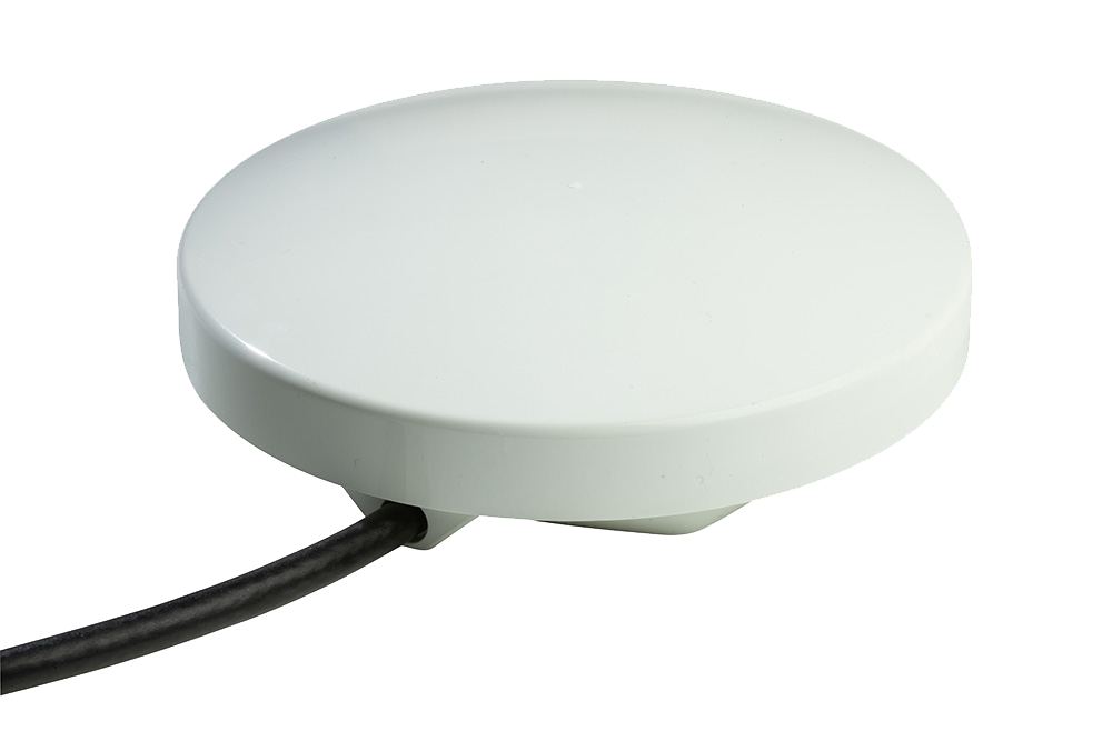
RockFLEET
The RockFLEET Tracker is a truly global tracking device designed for permanent use aboard marine vessels and land vehicles. Its optional LTE Narrowband unit allows it to use mobile phone networks when possible, automatically switching to the global Iridium satellite network when necessary (lowest-cost routing).
RockBLOCK 9603
RockBLOCK 9603 is a plug-and-play two-way global communications system designed to work with any computing platform with a serial or USB port, including Arduino™, Raspberry PI™, Intel Edison, Windows, Mac, and Linux computers. It’s a simple, low-cost, and reliable way to integrate two-way communications into any M2M system. It can send messages of 340 bytes and receive messages of 270 bytes using Iridium short burst data (SBD), which offers global, pole-to-pole coverage. It can transmit commands and receive data from almost any equipment on board so the potential applications are huge.
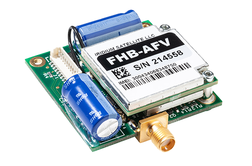
The tiny RockBLOCK 9603 (7.6cm x 5.1cm x 1.9cm) device uses either an onboard patch or external antenna using an optional SMA connector and a standard 0.1″ pitch connector for easy interfacing of equipment. Both of these aspects give greater flexibility in terms of onboard configuration of an M2M network – a vital aspect considering that ship and boat design varies massively.
Also available is the RockBLOCK Plus, designed for rugged applications, encapsulated in a waterproof IP68 housing, and including a 3m lead. It takes 9-30v DC power (instead of 5v on the RockBLOCK 9603) and RS-232 signals (instead of UART). RockBLOCK Plus is ideally suited for commercial organisations operating in hazardous or inclement environments. Essentially, it’s ideal for installing outside on your vessel.
RockBLOCK originally became popular in the so-called ‘makers’ market, where engineers, students, and inventors develop creative projects using IT and electronics components. Everything from oceanology to homemade space planes have used the RockBLOCK system to send and receive commands and the simplicity of the system transfers well to the maritime sector.
As an easy to implement and operate system suitable for all levels of technical expertise, RockBLOCK 9603 provides a diverse user-base with the ability to cost-effectively extend the ‘Internet of Things’ to maritime arena. Thousands of RockBLOCK units have been sold to date. Some notable projects include two-way communication duties on high-altitude balloon launches, a rocket-powered aircraft project, tracking the position of marine buoys for the Poseidon Project, and a marine oil spill response system designed and built by students.
Potential applications on ships and boats include security, automation, and engine monitoring. But unlike the headline, million-dollar complex VSAT networks that are part of the big data and smart shipping concepts, M2M communication using RockBLOCK 9603 is achieved on far more modest budgets. This means privately owned workboats, fishing boats, and yachts can benefit from M2M communication, for basically any application they can think of, while larger fleets can save money and supplement their VSAT systems with an M2M-only solution.
The low initial outlay and airtime costs are also driving maritime technology companies to develop commercial products using RockBLOCK 9603 as a foundation. Although the bandwidth available over Iridium SBD is relatively low compared to VSAT, the potential for developing commercial products that can make a real difference is high.
One innovative application is the use of Ground Control’s M2M communication technology on hyperbaric lifeboats, which are designed to safely transfer divers currently in saturation and unable to decompress for days – should there be cause to abandon their diving ship. Decompression from saturation would cause certain death so modern saturation diving vessels are fitted with at least one hyperbaric lifeboat that can carry up to 18 divers to safety.
When on board the diving vessel, any occupants of the saturation diving chambers will be monitored closely to ensure their health and safety. This poses a challenge should the occupants have to be moved to a hyperbaric lifeboat in an emergency, as the conditions inside the lifeboat chamber have to be maintained to close tolerances of temperature, gas mixture and pressure. The resources available to maintain these conditions within the lifeboat chamber are strictly limited and to maintain the conditions stable for any amount of time is difficult. This makes the monitoring of available resources and conditions within the chamber critical.
A UK-based instrumentation and data logging company for the commercial diving industry is developing a system to make data from hyperbaric lifeboats available over satcom. Though hyperbaric lifeboats have been around for 30 years, this is the first serious attempt to connect them to a monitoring network by satcom. A key challenge until now has been the size and power requirements of satcom antennas. There’s also been a cost consideration, with the majority of satcom services locking users into annual contracts. Considering not a single hyperbaric lifeboat has ever been launched in a real emergency, funding a fleet of lifeboats with an open satcom connection could become costly if using VSAT or other L-band services.
So to enable satcom for data transmission from a hyperbaric lifeboat, the development team has chosen RockFLEET. The system offers the same functionality as RockBLOCK while addressing the size, power, and cost challenges of installation on hyperbaric lifeboats. Operating on the same Iridium SBD service as RockBLOCK, RockFLEET has primarily been designed as an innovative ship tracker. However, Rock Seven (now trading as Ground Control) launched an M2M module in December 2014, opening the RockFLEET system up for a wealth of new applications.
On the cost side, there’s no annual contract, only pay-as-you-go use. The system provides pole-to-pole global position data and each M2M data transmission costs as little as £0.03.
The RockFLEET unit is only 13cm diameter and 4cm high and can easily be integrated with onboard equipment using a variety of serial protocols, whilst RockFLEET’s open API ensures data in any format can easily be delivered to users’ own applications. It’s also the only system of its kind to feature an onboard battery, so if it loses power from the vessel, it can keep on working for approximately two weeks (depending on the application and environment).
These attributes are the drivers behind this project to enhance communication from hyperbaric lifeboats, and should one ever need to be launched for real, the occupants will stand a better chance of being recovered safely when their rescuers have critical data available.
While RockBLOCK provides a singular approach to M2M data, RockFLEET consolidates two key aspects of maritime communication systems – vessel tracking and M2M data. Many shipping companies are keen on the concept of vessel tracking; it’s vital to know where all ships in a fleet are at any one time. But with today’s IT-focused maritime world, it’s now not just possible to receive data from vessels but almost essential to do so in order to operate as efficiently as possible.
With the M2M data module, RockFLEET can provide both position data and any other kind of data required – an advanced feature set, but one that doesn’t cost the earth and can help operations on even the smallest vessel improve through the use of low-cost data communication.
Can we help?
If you are looking for a reliable, secure, and easy-to-use vessel tracking device, then the RockFLEET is a great option. It uses LTE networks where available, and the Iridium satellite network when your device is out of cellular coverage.
Start a chat with our team today and discover how RockFLEET can enhance your marine operations. Complete our online form, or if you prefer to speak to someone directly, call us on +44 (0) 1452 751940 (Europe, Asia, Africa) or +1.805.783.4600 (North and South America). We’re standing by to help.
GSM Module Adds Least-Cost Data Routing
A new GSM module developed for the recently launched RockFLEET vessel tracking system introduces least cost routing functionality via terrestrial networks, giving users the opportunity to transmit position data via Iridium globally and switch to terrestrial networks when in range.
With user-definable position reports or short text messages from anywhere in the world costing as little as £0.03 (see SBD Service Plans), RockFLEET is already a highly competitive solution for vessel and fleet tracking and low-cost two-way messaging at sea. Launched in September 2014, Rock Seven (now trading as Ground Control)’s latest Iridium-based satellite tracking system now offers even greater cost control with the ability to send position reports to the shore office using GSM data when in range.
RockFLEET GSM functionality is a factory-fitted option that doesn’t change the size or compact form of the RockFLEET unit. It has no additional antenna for GSM use and can be supplied with a global roaming GSM SIM – or users can choose to install their own SIM from their preferred provider.
In addition to enabling least-cost routing of data (GSM when inshore and Iridium when offshore), users can take advantage of the increased throughput at a lower cost on GSM to send more data more often. This is especially relevant for the efficiency of coastal and inland vessels, considering the recent introduction of an M2M (machine-to-machine) data module for RockFLEET and its potential telemetry and automation applications.
“We continue to develop new capabilities for RockFLEET based on customer requests and market trends,” says Nick Farrell, director at Rock Seven t/a Ground Control. “The GSM module can reduce operational costs by switching to cheaper mobile networks, but it also gives access to more bandwidth than available offshore, so it can facilitate increased usage of RockFLEET position data transmission, two-way messaging, or M2M applications without increasing costs.”
Though focused on operational costs, RockFLEET is a sophisticated, rugged tracking device designed for maritime and land vehicle use. With no annual contract and pay-as-you-go use, RockFLEET is designed to simplify and reduce the cost of single vessel and entire fleet tracking, supporting ship and vehicle owners to increase safety and efficiency through improved fleet management. It provides pole-to-pole global position data using the Iridium short burst data (SBD) capability.
RockFLEET is the only GPS vessel-tracking device with an internal battery back-up, so it can continue to transmit position for up to two weeks if external power is cut. With facility to mount RockFLEET covertly, this makes it especially suitable for vessels traversing piracy hotspots.
Get in touch
If you are looking for a reliable, secure, and easy-to-use vessel tracking device, then the RockFLEET is a great option. It uses LTE networks where available, and the Iridium satellite network when your device is out of cellular coverage. Perfect for a variety of maritime applications and backed by a team of experts who are dedicated to providing you with the best possible support.
Start a chat with our team today and discover how RockFLEET can enhance your marine operations. Complete our online form, or if you prefer to speak to someone directly, call us on +44 (0) 1452 751940 (Europe, Asia, Africa) or +1.805.783.4600 (North and South America). We’re standing by to help.