Topic: Asset Tracking
RockAIR Dual Mode Tracking
Using a locally sourced cellular SIM card, or global cellular SIM provided by us, that’s loaded with cellular data, you now have the option of sending tracking reports once every 15 seconds, whenever you’re operating in cell range. The best part? There’re no additional charges for these faster reports.
Traditionally, when you purchase a bundle of credits from us to operate your tracking device, every single position report will use one credit. Now, with the option of cellular tracking, these messages won’t diminish your credit pool – instead, these cellular positions are free. You can even have your RockAIR send these cellular position reports faster than satellite ones to make sure you don’t burn through your credits too quickly.
Beyond the obvious cost savings, this is also a very useful safety feature. With the incredible cellular coverage the world’s now experiencing, search areas for aircraft using cellular tracking will now drastically decrease. By using the power of dual sat/cell tracking, you get complete peace of mind regardless of the location you’re flying in.
For example, if you’re flying at 100 knots using a satellite-only device to transmit at a typical two-minute interval, your potential search area is roughly 116 sqkm (72sqm) if something were to happen. However, if you were using a dual mode device, such as a RockAIR, and you were reporting within cellular range at 15 seconds, the potential search area is significantly reduced to a very small 1.9sqkm (1.18sqm).
The RockAIR intuitively changes between satellite and cellular modes as well. If the unit is struggling to retrieve a cellular signal from its GSM antenna, then it will stop trying to send via cell and will switch to satellite tracking – seamlessly. There’ll be no downtime during this switch.
Dual mode tracking is incredibly easy to set up as well:
1. Open up RockCONNECT on your smartphone or tablet.
2. Select the RockAIR you’d like to connect with, assuming it’s turned on.
3. Select ‘Configure’ then type in ‘1234’ if prompted for a pin.
4. Select ‘Tracking > Satellite Context’ and change the ‘Transmit Frequency’ to your preferred satellite tracking rate.
5. Select ‘Tracking > Cellular Context’ and change the ‘Transmit Frequency’ to your preferred cellular tracking rate.
And that’s it. You’re ready to send tracking reports on either cellular or satellite.
RockSTAR Alerts
Navigating to the ‘Alerts’ section within the main menu of your RockSTAR, you’ll be greeted by six alert types and an alert cancel. Here’s what each one means:
1. Timer Alert
The idea behind the timer alert is a one-time alert after a set time limit has expired. Set the timer for a time interval of your choosing. Once that time has expired, a ‘timer alert’ is sent from the RockSTAR to the server/first responders. They’re now aware that the timer has expired without human interaction turning it off. This is a one-time alert. The timer doesn’t reset afterwards.
Possible Use Case:
You’re in a remote location and are expected to be doing a job for 30 minutes. Set the timer for 60 mins and if it goes off then your responders know that you have taken twice the amount of time expected and they should do their level best to make contact.
2. Dead Man’s Switch
This is similar to the timer alert, except this is a recurring alert. Once the timer has been set, you’ll have 20 seconds before that time frame reaches its limit to push the ‘ok’ button to cancel the alert from being sent. You’re notified of this 20-second window by loud, consistent beeping from the unit. Once the timer cycle has completed, or you’ve pressed the ‘ok’ button during the beeping sequence, it refreshes and starts again.
Possible Use Case:
If you’re in an unsafe territory or doing a dangerous task, the dead man’s switch is a brilliant idea to ensure that you are constantly checking in with your team to assure them you’re ok and unharmed. As RockSTARs have set frequencies to send position reports, the dead man’s switch guarantees the unit hasn’t been left lying around giving off the impression that you’re safe, when you actually need assistance.
3. Temperature Alert
This is triggered when the values you have set are exceeded. You can set the high and low temperatures to values you think reflect the environment you’re operating in. These values relate to the RockSTAR board and circuitry, so the exterior might be incredibly hot or cold, but it’s the interior components that are being monitored. Once these temperatures are exceeded, an alert is sent so you can regulate the temperature.
Possible Use Case:
If you’re fighting fires or doing research in a cold environment, this alert is perfect to ensure you don’t damage your device.
4. Power Alert
If you’ve connected your RockSTAR to an external power source, then once the external power is removed, the unit detects ‘power loss’ and will send a message accordingly. If you have set your unit to ‘power mode’, so it only turns on with external power, and you remove the power source, then it will stay awake long enough to send a ‘power loss alert’ to the server. This way, each time the unit is turned off, someone is alerted.
Possible Use Case:
If you’re driving long distances in remote areas and require tracking without having to worry about battery life, then power loss alerts are a great way to inform you if your tracking has stopped, without having to wait for the scheduled report to be missing from the mapping.
5. Geofence Alert
There are two options for Geofence Alert – user and polygon. We’ll talk about user here. To learn about polygons, contact our support team and they’ll explain further.
A geofence draws an imaginary circle around a center point, and if that circle is left, an alert is sent notifying you of that breach. By pressing ‘centre point’ in this menu, you’re allowing the RockSTAR to record your GPS location. It then draws a circle based on the distance you’ve chosen. You then select how often you want the unit to check to see if you’re still in that circle. As soon as you leave it, an alert is sent.
Possible Use Case:
If you’re assigned an area for a specific reason – research, pest control, etc. – then geofences are a great way to ensure you keep to your assigned area and don’t encroach on prohibited or protected land.
6. Collision Alert
Inside each RockSTAR is an accelerometer. If you set the threshold of the unit to an appropriate G-force value and the duration that the unit sustains that G-force is exceeded, the accelerometer measures this and will send an alert notifying of this exceedance.
Possible Use Case:
Any situation that the unit is installed in a vehicle, this alert is a great tool to determine if the vehicle has sustained a server impact. By altering the threshold and duration, you can ensure that the unit only triggers when a crash occurs, as opposed to hitting uneven ground at speed.
Send Alert Cancel
Any time that an alert has been sent that you couldn’t stop in time, sending a cancel message will allow the responders to know not to misinterpret the alert that was just received.
If you’d like to know anything further about these alerts, or geofence polygons, don’t hesitate to reach out to our support team and we’ll do our best to assist.
Get in touch
We take pride in designing and building the RockSTAR ourselves. Over the years we’ve enhanced and added features based on feedback and specific customer requests, to ensure our device meets your needs.
Simply complete the form to find out whether the RockSTAR is the right fit for your organization. With our 20 years of expertise, we’ll guide you in making the optimal choices for your critical communication requirements. If you prefer to speak to someone directly, call us on +44 (0) 1452 751940 (Europe, Asia, Africa) or +1.805.783.4600 (North and South America).
RockBLOCK 9603 used in MIRKA2-RX Mission
With the completion of the MIRKA2-RX mission, the student members of the Small Satellite Group of the University of Stuttgart field tested technology that will be used in a future CubeSat mission.
The MIRKA2-RX mission that launched on March 18th, 2016, consisted of a micro re-entry capsule (MRC) and the newly developed Low Orbit Technical Unit Separator (LoTUS) which were both integrated within a REXUS program rocket.
The European REXUS/BEXUS program supports scientific and technological experiments on research rockets and balloons, sending two of each into space every year.
132 seconds after lift-off, and while the REXUS rocket was at apogee, a pyro cutter onboard the separator would cut the wire securing the MRC to the separator carriage, thus ejecting it out into the upper atmosphere.
The ejection would also trigger a mechanical switch enabling battery-assisted data collection from pressure, temperature, acceleration and radiation sensors placed inside the MRC.
While the mechanical switch wasn’t successfully activated during the successful ejection, the MRC’s landing on snow-covered Swedish tundra, was. Now active, the MRC used its RockBLOCK 9603 modem and antenna to send back telemetry via Rock Seven (now trading as Ground Control)’s API and server to the MIRKA2-RX team’s own server, allowing the team to locate the device.
The separator integrated into the MIRKA2-RX mission was also designed to fit inside a forthcoming CubeSat Atmospheric Probe for Education (CAPE) mission developed by the University of Stuttgart Institute of Space Systems (IRS). The CAPE mission will test heat shield materials and a pulsed plasma thruster.
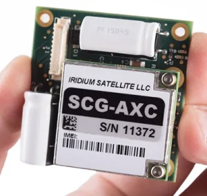
RockBLOCK 9603
RockBLOCK 9603 is targeted primarily at systems integrators and product developers where space inside your enclosure is at a premium. RockBLOCKs can send and receive short messages from anywhere on Earth with a view of the sky.
Team Peruagus Uses RockBLOCK to Rule the Waves
Researching how autonomous technology can be applied in the maritime industry, six ship science students from the University of Southampton designed and built the Peruagus, an autonomous solar-powered boat.
Once sea trials are completed, the Peruagus will take on the Microtransat Challenge and attempt to be the first in its non-sailing class to complete an east-to-west transatlantic crossing. Peruagus stands apart from the majority of teams that previously attempted the challenge by relying solely on sustainable solar energy to power its propeller and two rudders.
The Peruagus is also unique in that it’s self-righting – that is, able to recover unassisted from a capsized position. The boat’s hull is made up of a solid foam core sandwiched between two layers of fiberglass. This makes the Peruagus robust, practically unsinkable while intact, and cheaper to build than most boats of similar size.
The Peruagus features an aluminum skeleton that functions as a heat sink to keep on-board equipment cool, and an epoxy keel that provides directional stability. The finished design is modular, allowing installation of weather monitoring equipment, different keels, even different superstructures and power systems.
Peruagus, meaning ‘roamer’ in Ancient Greek, will be using a RockBLOCK 9603 to send back telemetry data and to receive waypoint instructions as it makes its way west across the Atlantic with the help of a PixHawk Autopilot.
Can We Help You?
With 20 years of experience, we can help you make the best choices for your remote connectivity, whether you need one or several thousand devices!
We’re not invested in selling you a specific product or connections, just the best solution for your needs.
Call us on +44 (0) 1452 751940 (Europe, Asia, Africa, Oceania) or 800 773 7168 (North and South America), complete the form, or email hello@groundcontrol.com.
RockFLEET Approved by Queensland for VMS
The proven RockFLEET global tracking and messaging system, manufactured by Ground Control, has been selected as one of four approved devices in a mandated scheme to install a Vessel Monitoring System (VMS) to all commercial fishing boats in Queensland, Australia.
Under the terms of the scheme, all commercial fishing and charter boats will require a vessel-tracking device to be fitted and operational by 2020. Net, crab, and line boats, meanwhile, will need to have a VMS in place from 1 January 2019. Ground Control’s trusted partner Option Audio will be managing the installation and ongoing management of the units in-country (www.commercialfishingtracker.com).
RockFLEET is the only Iridium-based solution available for Queensland’s fishing vessels. Its proven reliability ensures skippers can always meet reporting requirements under the scheme, with low initial outlay and airtime costs, while the compact, lightweight design makes it easy to install. The global two-way communication ability, low purchase and running costs, and – most importantly – the reliability of the Iridium network, gives clear advantages over the other options available.
“The decision to implement RockFLEET as an approved device for this scheme is a measure of the unit’s proven success in communicating detailed and highly reliable vessel position data,” said Ric Searle, CTO of Ground Control. “We’re proud to have been selected as it’s a testament to Ground Control’s increasing prominence in commercial VMS applications.”
The commercial fishing industry is of crucial importance to the economic wellbeing of Australia’s coastal communities. According to the Queensland Government Departure of Agriculture and Fisheries, Queensland’s fishing fleet of several thousand licensed commercial fishing vessels accounts for 10% of Australia’s seafood production in both quantity and value.
“Vessel tracking is a key element of the Queensland Sustainable Fisheries Strategy 2017-2027,” observes Mark Furner, Minister for Agricultural Industry Development and Fisheries, “paving the way for a world-class fisheries management system.”
Furner adds that Queensland’s commercial trawl fisheries have deployed vessel tracking for 15 years. “This has helped them to demonstrate the sustainability of their fishery, particularly operating in a World Heritage Area.”
The new mandated tracker scheme for commercial fishing boats will enable Fisheries Queensland to monitor fishing quotas and compliance with area and seasonal closures, while also validating logbook data in terms of the time and location of fishing excursions. The collated data will also provide invaluable information and insights with regard to fish biomass.
“RockFLEET will be central to this timely and necessary strategy for vessel-tracking and communication,” says Searle, “and will be of immense assistance in securing a bright and sustainable future for Queensland’s vital commercial fishing fleet.”
RockAIR Approved by United States Fire Service
Via our aviation partner TracPlus USA Inc, we’re pleased to announce that the RockAIR flight tracker has been approved by the United States Fire Service (USFS) for use on airborne fire-fighting operations, effective immediately.
The RockAIR brings satellite and cellular tracking together in a portable carry-on, carry-off form factor at a much lower cost than traditional dual-mode solutions.
Tracplus’ chief innovation officer, Chris Hinch, said: “We’re absolutely delighted to bring the revolutionary capabilities and affordability of the RockAIR to the US firefighting market. With nearly ten years of global customer experience and insights in airborne firefighting built into the RockAIR, USFS’s approval of the RockAIR is a hugely satisfying validation of our technology and recognition of our commitment to our customers operating in this critical market.”
While tracking systems for light aircraft already exist, Ground Control has introduced a wealth of new features designed to bring extra functionality and safety through the RockAIR system. For starters, RockAIR is the only dashboard-mounted tracking system to offer dual-mode functionality over satcom and cellular networks. The solution provides lower-cost GSM-based tracking when in cellular range, and reliable failover to an Iridium satellite when outside of built-up areas.
Whether the aircraft is working over a city or is in the middle of the Sahara, GPS coordinates will be automatically transmitted using whichever network is available and most cost-effective. This also provides an extra layer of safety and security not available in existing systems.
Enhancing safety even further, RockAIR is the only carry-on tracking system for light aircraft to feature an integrated back-up battery. The battery will automatically take over should the 9-30V DC or Micro USB power be interrupted. While this feature is vital for emergencies, it can also provide a level of security against theft or unauthorised use of an aircraft.
RockAIR is CE, IC, FCC, and DO160 certified, and at 119 x 100 x 25mm/210g, it’s easy to carry on board and attach to the included dashboard quick-release clip. It features its own built-in antenna but can also work with an external antenna, allowing complete flexibility of installation location.
In action, RockAIR can automatically transmit a GPS position as often as every 15 seconds or as infrequently as once every 24 hours, all easily configured by the user. The unit also allows tracking profiles to be setup to enable faster rates if the integrated alert button has been pressed, if external power is applied, or if cellular data is being used rather than satellite. RockAIR also features a ‘Watch Me’ feature, accessible via the keypad, which informs the provider that more active monitoring is required for a period of time.
Get in touch
We have over 20 years’ experience delivering satellite-enabled asset tracking solutions to aviators worldwide.
We’re proud to design and build our own hardware, and we work with other leading manufacturers and airtime providers to ensure that all of our customers get the best solution for their needs.
Just complete the form and we’ll respond with impartial, expert advice.
New Tracking and IoT System Touches Down for Vehicle Fleet Owners
Ground Control brings its innovative RockAIR tracking system back down to earth by officially making it available for land-based applications. The move is a result of high levels of interest in RockAIR’s low-cost, dual-mode communication and feature-packed approach to tracking and safety, already enjoyed by land vehicle fleet owners and operators in the military, charity, and commercial organisations.
With RockAIR, Rock Seven (now trading as Ground Control) initially delivered a ‘carry-on’ cockpit-mounted tracking system for helicopters and light aircraft that not only provided precise location reporting globally, it also introduced new internet of things (IoT) functionality that allowed pilots to send and receive messages and data over the internet. This unique feature-set also has the power to support safety and operational efficiency for diverse users on land, especially for vehicles operated by aid agencies and the military that may be travelling in potentially risky environments.
At its core, RockAIR provides regular GPS location reports from anywhere in the world over the Iridium satellite network or GSM networks at user-defined intervals, ensuring fleet managers know the whereabouts of their assets and people at all times. The dual satellite/mobile functionality provides lower-cost GSM-based tracking when in cellular range, and reliable failover to an Iridium satellite when outside of built-up areas. GPS coordinates are automatically transmitted using whichever network is available and most cost-effective, providing an extra layer of safety and security not available in single channel systems.
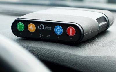
RockAIR
The RockAIR is a global tracking and messaging device designed for use on the dashboard of light aircraft, rotorcraft, and land-based vehicles.
It has built-in LTE Narrowband, which allows it to use terrestrial mobile phone networks when possible, automatically switching to the global Iridium satellite network when LTE Narrowband is not available.
Building on its dual mode functionality, RockAIR offers new features designed to improve safety for vehicles operating in unfamiliar or dangerous locales. It can automatically transmit a GPS position as often as every 15 seconds or as infrequently as once every 24 hours, all easily configured by the user.
It also allows tracking profiles to be setup to enable faster rates if the integrated alert button has been pressed, if external power is applied (e.g., vehicle ignition), or if cellular data is being used rather than satellite. RockAIR also features a ‘Watch Me’ feature, accessible via the keypad, which informs the provider that more active monitoring is required for a period of time, enabling personnel in vehicles to react to situations that may escalate quickly, for example, during civil unrest or active combat.
While delivering precise tracking is RockAIR’s primary application, Ground Control has integrated extra functionality that takes advantage of the always-on connection the system keeps to the Iridium satellite and GSM networks.
Users can send and receive low-cost short emails and text messages using the free (iOS/Android) companion app over Bluetooth, ensuring that regardless of location, they can report back to base. RockAIR is also a true IoT device. It features a RS-232 port, which can be used for machine-to-machine data, enabling users to connect sensors and computing platforms to the internet. A Bluetooth API makes it easy for organisations to create their own apps that make use of the highly reliable connectivity RockAIR provides to benefit their specific operations.
Nick Farrell, director at Rock Seven (now trading as Ground Control), said: “While NGO and military organisations face completely different challenges from the general aviation sector, RockAIR’s tracking and data functionality is just as effective for improving safety and logistics on the dashboard of an SUV or troop carrier as it is in the cockpit of a helicopter or light aircraft. The interest we’ve received from organisations looking at land applications for RockAIR is huge, and we encourage fleet owners to get in touch to discuss how the system can help them to monitor and control their vehicles more effectively and for a lower cost.”
Get in touch
We have over 20 years’ experience delivering satellite-enabled asset tracking solutions to aviators worldwide.
We’re proud to design and build our own hardware, and we work with other leading manufacturers and airtime providers to ensure that all of our customers get the best solution for their needs.
Just complete the form and we’ll respond with impartial, expert advice.
RockSTAR Supporting Catching of Poachers
In the Irkutsk region of Russia (Lake Baikal), there are a lot of national parks and reserves. These are very remote and difficult-to-reach locations where hunting is usually prohibited – but there are a lot of poachers. There are no mobile phone masts or means of terrestrial communication.
In the woods of Irkutsk, there are a lot of small wooden huts. They’re called “zimniki” – a shelter which gives a safe place for park rangers to stay overnight. The rangers go to each hut twice a year as a routine. One of the park ranger’s jobs is to try to prevent poaching, but with such a huge area in such an inhospitable environment, that’s an incredibly hard job… and so they have come up with an ingenious way to do it!
This year they visited each of the wooden huts in November and left one RockSTAR tracker in each hut, hidden away, sending a report once a day. As well as automatically sending tracking data from anywhere on Earth, the RockSTAR units have an inbuilt temperature sensor with an alert mode, and so the park rangers set this at five degrees C. If the temperature went above that, the RockSTAR would send a special alert message.
The RockSTAR Two-Way Messenger is a truly global communication device and tracking system. It allows you to send and receive short messages from anywhere on Earth with a clear view of the sky. It works far beyond the reach of Wi-Fi and GSM networks.
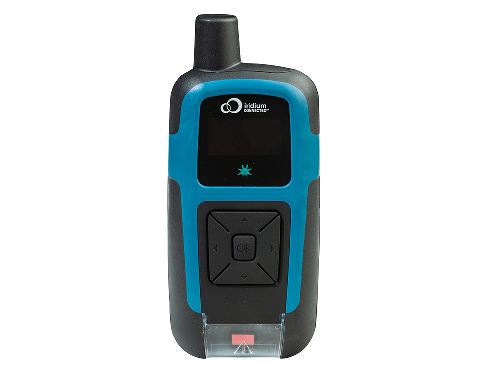
To survive in the harsh temperatures, the poachers will use the huts to get through the night. When they visit the huts, they’ll warm them up and trigger the temperature alert. And, hey presto, the message is received immediately, and the local authorities know exactly which hut is being used by a poacher that night.
This feature was never designed for this use but we fully support any use of our equipment which helps protect the world in which we live, so congratulations to the lateral-thinking rangers, and to our Russian partner MVS, on helping them achieve their goals.
Get in touch
With over 20 years of satellite experience, the Ground Control team is well placed to help keep you connected when it matters the most.
Whatever your communication or connectivity needs, we can help. Talk to one of our team to discover our products and services and how they can benefit, improve and streamline your applications.
Instant Detect – Monitoring Wildlife Through Satellite Imagery
Instant Detect is a State-of-the-Art Conservation System
Instant Detect is a conservation system designed to remotely monitor wildlife population and movements, and to play a leading role in anti-poaching efforts. The Zoological Society of London (ZSL) developed Instant Detect with funding from Google’s Global Impact Award, which it won in 2013.
UK-Based Remote Monitoring
With the monitoring HQ in London, the Instant Detect cyber safety net is a truly global application of technology. The system has been used in Antarctica to monitor penguin populations and in Kenya in collaboration with the Kenyan Wildlife Service to tackle elephant and rhino poaching. The Tsavo region of Kenya alone has seen more than 1,000 rhinos killed in the last 18 months.
Traditional wildlife monitoring systems rely on SD cards or mobile cellular networks to save or upload images and data. These systems suffer due to lack of real-time imagery or simply don’t work when mobile coverage is lacking.
Joint Collaboration
Instant Detect was developed in collaboration with Cambridge consultants Iridium, Seven Technologies Group, and Wireless Innovation Ltd (now trading as Ground Control) in response to these issues. The covert system now sends data instantly via satellite to the ZSL team. When human activities trigger the system sensors – particularly with the presence of metal – the team alerts rangers to the presence of poachers with photographic proof. This early warning allows local enforcement to react quickly and keep a virtual eye on remote regions.
Get in touch
Whether you have your own Environmental monitoring and reporting software, or are an OEM responsible for manufacturing meteorological sensors, if you want to explore integration options with Ground Control’s satellite connectivity devices, we’d love to hear from you.
Simply complete the form and one of our experienced team will contact you.
ActivitySense – How it Works
Our RockSTAR and RockFLEET devices are used throughout the world, tracking all sorts of things – people, vehicles, machines, animals. Most of the time you set a transmission frequency for the unit (e.g. once every 15 minutes), attach the tracker, and then leave it to do its job.
However, over the years we’ve been asked whether this speed could vary, depending on the motion of whatever the tracker was attached to.
So we’ve come up with ActivitySense.
ActivitySense has been introduced in the latest version of firmware for RockSTAR and RockFLEET units. It uses a combination of sensors to determine whether something is moving. The problem is, different things move in different ways – so how do we cope with that? Let’s take a look.
ActivitySense on Cars and Bikes
When a car’s engine is running and driving along the road, there tends to be an element of vibration. When the car or bike stops and the engine is turned off, that vibration goes away. To detect this, we use a mode called ‘Bump’, which employs the accelerometer inside the tracker. If we detect vibration continually for a period of 10 seconds, we start transmitting at a faster rate. When that vibration has stopped for 60 seconds or more, then we drop the unit back down to its normal transmission rate.
Obviously different vehicles have different levels of vibration, so we have an adjustable threshold, meaning you can tune the detection to match your particular requirements.
ActivitySense on Airplanes
While an airplane will tend to vibrate and bump around when on the ground, once it reaches cruising altitude and throttles back, most of that vibration goes away. So we can’t use the same vibration-detection method we use on cars and bikes.
Instead we use the GPS chip and have a mode called ‘Bump+GPS’ – the vibration on the ground initially wakes the unit up and turns on the GPS chip. The transmission speed increases. We then monitor the speed of the plane via the GPS chip, and we keep transmitting more quickly until the GPS speed drops below 4mph, as the plane is hardly likely to be in the air at that speed. Then we drop the transmission rate down again and wait for bumps to wake it up next time.
ActivitySense via Power
For some applications, we’ve been asked if our units can transmit more quickly when receiving external power – and less quickly when running from batteries. Again, we have a mode in ActivitySense to detect this, simply called ‘Power’. If external power is applied then the tracking frequency can be faster than if running on battery.
A good example of this is one of our customers, who uses units on rapid deployment rigid inflatable boats. Whilst the boats are ‘docked’ on the mother-ship, they transmit once every two hours. As soon as the ignition is switched on, they start taking positions every five seconds, transmitting once a minute.
Cost Savings
Apart from the flexibility ActivitySense gives our customers, by automatically managing how often it transmits at different times, it also saves them money. Each position report transmitted over the Iridium satellite network costs money, so why transmit every five minutes for days on end when whatever you’re tracking is sat in the same place?
To find out more about ActivitySense, or any of the other features of our products, get in touch below.
Get in touch
We’ve implemented satellite IoT infrastructure for decades, and there’s very rarely been an obstruction issue we couldn’t overcome with a bit of knowledge and ingenuity.
We’d be happy to talk to you about your project and offer impartial advice on the best antenna and satellite service for your particular requirements. Call or email us, or complete the form.
M2M Communication for Smaller Vessels
‘Big data’ has become part of the Maritime lexicon in recent years. It’s hailed as the answer to achieving operational efficiencies, and is part of the reason that the demand for bandwidth at sea continues to grow.
The use of big data somewhat reflects how internet usage patterns at sea follow that of businesses on land. As satellite capacity grows, service providers, IT companies, and equipment manufacturer work out ways to use it to gain efficiencies and ultimately save costs for ship owners and operators. Many of these applications are based on the concept of machine-to-machine communication, also known as M2M. Sensors in onboard equipment can talk directly with applications on land via satcom – delivering automated reports and statistics, for instance, which can be leveraged to understand vessel performance better.
Though M2M applications can run over the VSAT equipment found on ships, the use of M2M communication isn’t limited to large commercial vessels. New systems have been developed that focus on understanding the challenges of communicating at sea for smaller vessels, especially in terms of cost, security, and the lack of space onboard, which may rule out the installation of a large satcom antenna. So with smaller, lower-cost equipment and lower-bandwidth services, the world of M2M is opening up for vessels of all types and size. ‘Small data’, if you like.
Ground Control is at the forefront of this scaling-down of satcoms for M2M applications, with its RockFLEET and RockBLOCK products.
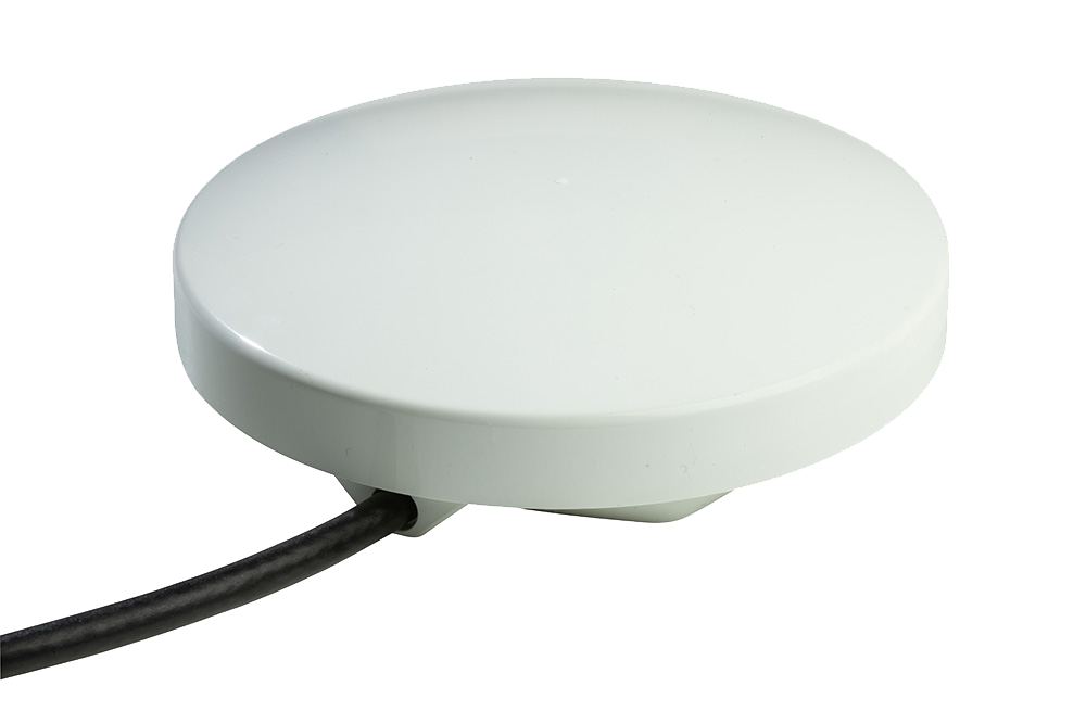
RockFLEET
The RockFLEET Tracker is a truly global tracking device designed for permanent use aboard marine vessels and land vehicles. Its optional LTE Narrowband unit allows it to use mobile phone networks when possible, automatically switching to the global Iridium satellite network when necessary (lowest-cost routing).
RockBLOCK 9603
RockBLOCK 9603 is a plug-and-play two-way global communications system designed to work with any computing platform with a serial or USB port, including Arduino™, Raspberry PI™, Intel Edison, Windows, Mac, and Linux computers. It’s a simple, low-cost, and reliable way to integrate two-way communications into any M2M system. It can send messages of 340 bytes and receive messages of 270 bytes using Iridium short burst data (SBD), which offers global, pole-to-pole coverage. It can transmit commands and receive data from almost any equipment on board so the potential applications are huge.
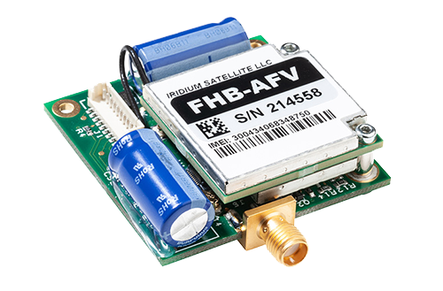
The tiny RockBLOCK 9603 (7.6cm x 5.1cm x 1.9cm) device uses either an onboard patch or external antenna using an optional SMA connector and a standard 0.1″ pitch connector for easy interfacing of equipment. Both of these aspects give greater flexibility in terms of onboard configuration of an M2M network – a vital aspect considering that ship and boat design varies massively.
Also available is the RockBLOCK Plus, designed for rugged applications, encapsulated in a waterproof IP68 housing, and including a 3m lead. It takes 9-30v DC power (instead of 5v on the RockBLOCK 9603) and RS-232 signals (instead of UART). RockBLOCK Plus is ideally suited for commercial organisations operating in hazardous or inclement environments. Essentially, it’s ideal for installing outside on your vessel.
RockBLOCK originally became popular in the so-called ‘makers’ market, where engineers, students, and inventors develop creative projects using IT and electronics components. Everything from oceanology to homemade space planes have used the RockBLOCK system to send and receive commands and the simplicity of the system transfers well to the maritime sector.
As an easy to implement and operate system suitable for all levels of technical expertise, RockBLOCK 9603 provides a diverse user-base with the ability to cost-effectively extend the ‘Internet of Things’ to maritime arena. Thousands of RockBLOCK units have been sold to date. Some notable projects include two-way communication duties on high-altitude balloon launches, a rocket-powered aircraft project, tracking the position of marine buoys for the Poseidon Project, and a marine oil spill response system designed and built by students.
Potential applications on ships and boats include security, automation, and engine monitoring. But unlike the headline, million-dollar complex VSAT networks that are part of the big data and smart shipping concepts, M2M communication using RockBLOCK 9603 is achieved on far more modest budgets. This means privately owned workboats, fishing boats, and yachts can benefit from M2M communication, for basically any application they can think of, while larger fleets can save money and supplement their VSAT systems with an M2M-only solution.
The low initial outlay and airtime costs are also driving maritime technology companies to develop commercial products using RockBLOCK 9603 as a foundation. Although the bandwidth available over Iridium SBD is relatively low compared to VSAT, the potential for developing commercial products that can make a real difference is high.
One innovative application is the use of Ground Control’s M2M communication technology on hyperbaric lifeboats, which are designed to safely transfer divers currently in saturation and unable to decompress for days – should there be cause to abandon their diving ship. Decompression from saturation would cause certain death so modern saturation diving vessels are fitted with at least one hyperbaric lifeboat that can carry up to 18 divers to safety.
When on board the diving vessel, any occupants of the saturation diving chambers will be monitored closely to ensure their health and safety. This poses a challenge should the occupants have to be moved to a hyperbaric lifeboat in an emergency, as the conditions inside the lifeboat chamber have to be maintained to close tolerances of temperature, gas mixture and pressure. The resources available to maintain these conditions within the lifeboat chamber are strictly limited and to maintain the conditions stable for any amount of time is difficult. This makes the monitoring of available resources and conditions within the chamber critical.
A UK-based instrumentation and data logging company for the commercial diving industry is developing a system to make data from hyperbaric lifeboats available over satcom. Though hyperbaric lifeboats have been around for 30 years, this is the first serious attempt to connect them to a monitoring network by satcom. A key challenge until now has been the size and power requirements of satcom antennas. There’s also been a cost consideration, with the majority of satcom services locking users into annual contracts. Considering not a single hyperbaric lifeboat has ever been launched in a real emergency, funding a fleet of lifeboats with an open satcom connection could become costly if using VSAT or other L-band services.
So to enable satcom for data transmission from a hyperbaric lifeboat, the development team has chosen RockFLEET. The system offers the same functionality as RockBLOCK while addressing the size, power, and cost challenges of installation on hyperbaric lifeboats. Operating on the same Iridium SBD service as RockBLOCK, RockFLEET has primarily been designed as an innovative ship tracker. However, Rock Seven (now trading as Ground Control) launched an M2M module in December 2014, opening the RockFLEET system up for a wealth of new applications.
On the cost side, there’s no annual contract, only pay-as-you-go use. The system provides pole-to-pole global position data and each M2M data transmission costs as little as £0.03.
The RockFLEET unit is only 13cm diameter and 4cm high and can easily be integrated with onboard equipment using a variety of serial protocols, whilst RockFLEET’s open API ensures data in any format can easily be delivered to users’ own applications. It’s also the only system of its kind to feature an onboard battery, so if it loses power from the vessel, it can keep on working for approximately two weeks (depending on the application and environment).
These attributes are the drivers behind this project to enhance communication from hyperbaric lifeboats, and should one ever need to be launched for real, the occupants will stand a better chance of being recovered safely when their rescuers have critical data available.
While RockBLOCK provides a singular approach to M2M data, RockFLEET consolidates two key aspects of maritime communication systems – vessel tracking and M2M data. Many shipping companies are keen on the concept of vessel tracking; it’s vital to know where all ships in a fleet are at any one time. But with today’s IT-focused maritime world, it’s now not just possible to receive data from vessels but almost essential to do so in order to operate as efficiently as possible.
With the M2M data module, RockFLEET can provide both position data and any other kind of data required – an advanced feature set, but one that doesn’t cost the earth and can help operations on even the smallest vessel improve through the use of low-cost data communication.
Can we help?
If you are looking for a reliable, secure, and easy-to-use vessel tracking device, then the RockFLEET is a great option. It uses LTE networks where available, and the Iridium satellite network when your device is out of cellular coverage.
Start a chat with our team today and discover how RockFLEET can enhance your marine operations. Complete our online form, or if you prefer to speak to someone directly, call us on +44 (0) 1452 751940 (Europe, Asia, Africa) or +1.805.783.4600 (North and South America). We’re standing by to help.
GSM Module Adds Least-Cost Data Routing
A new GSM module developed for the recently launched RockFLEET vessel tracking system introduces least cost routing functionality via terrestrial networks, giving users the opportunity to transmit position data via Iridium globally and switch to terrestrial networks when in range.
With user-definable position reports or short text messages from anywhere in the world costing as little as £0.03 (see SBD Service Plans), RockFLEET is already a highly competitive solution for vessel and fleet tracking and low-cost two-way messaging at sea. Launched in September 2014, Rock Seven (now trading as Ground Control)’s latest Iridium-based satellite tracking system now offers even greater cost control with the ability to send position reports to the shore office using GSM data when in range.
RockFLEET GSM functionality is a factory-fitted option that doesn’t change the size or compact form of the RockFLEET unit. It has no additional antenna for GSM use and can be supplied with a global roaming GSM SIM – or users can choose to install their own SIM from their preferred provider.
In addition to enabling least-cost routing of data (GSM when inshore and Iridium when offshore), users can take advantage of the increased throughput at a lower cost on GSM to send more data more often. This is especially relevant for the efficiency of coastal and inland vessels, considering the recent introduction of an M2M (machine-to-machine) data module for RockFLEET and its potential telemetry and automation applications.
“We continue to develop new capabilities for RockFLEET based on customer requests and market trends,” says Nick Farrell, director at Rock Seven t/a Ground Control. “The GSM module can reduce operational costs by switching to cheaper mobile networks, but it also gives access to more bandwidth than available offshore, so it can facilitate increased usage of RockFLEET position data transmission, two-way messaging, or M2M applications without increasing costs.”
Though focused on operational costs, RockFLEET is a sophisticated, rugged tracking device designed for maritime and land vehicle use. With no annual contract and pay-as-you-go use, RockFLEET is designed to simplify and reduce the cost of single vessel and entire fleet tracking, supporting ship and vehicle owners to increase safety and efficiency through improved fleet management. It provides pole-to-pole global position data using the Iridium short burst data (SBD) capability.
RockFLEET is the only GPS vessel-tracking device with an internal battery back-up, so it can continue to transmit position for up to two weeks if external power is cut. With facility to mount RockFLEET covertly, this makes it especially suitable for vessels traversing piracy hotspots.
Get in touch
If you are looking for a reliable, secure, and easy-to-use vessel tracking device, then the RockFLEET is a great option. It uses LTE networks where available, and the Iridium satellite network when your device is out of cellular coverage. Perfect for a variety of maritime applications and backed by a team of experts who are dedicated to providing you with the best possible support.
Start a chat with our team today and discover how RockFLEET can enhance your marine operations. Complete our online form, or if you prefer to speak to someone directly, call us on +44 (0) 1452 751940 (Europe, Asia, Africa) or +1.805.783.4600 (North and South America). We’re standing by to help.