Topic: Cellular
The Role of 3GPP Standards in Advancing Cross-Border Asset Tracking
Even in the age of eSIM technology, there remain challenges in tracking road, rail and ocean freight across borders. This post focuses on a key challenge: connectivity. Less than 40 percent of the Earth’s land surface is covered by mobile networks. This figure drops to just 12 percent when oceans are taken into account. So, assets moving out of cellular coverage have had two options: accept gaps in tracking, or utilize satellite connectivity.
The former isn’t an appealing option; freight is vulnerable to theft, adverse weather conditions, damaged infrastructure (roads, bridges etc.), breakdowns etc., all of which can be mitigated, or at least dealt with rapidly, if real-time, global monitoring is available.
The latter – satellite connectivity – has been a mainstay of high value freight for many years, but the relatively high cost of satellite tracking devices, plus airtime, has meant that some organizations with extensive asset inventories or limited budgets haven’t been able to take advantage of the technology.
3GPP standards are poised to lower the cost barrier to satellite connectivity, both directly and indirectly, unlocking truly global asset tracking capabilities to the benefit of logistics, agriculture, manufacturing, healthcare, and many other industries.
3GPP’s Impact on Connectivity
3GPP is an initiative to create global standards for telecommunications, ensuring that a device developed and operated in North America would be able to connect to networks in Asia, Europe, Africa etc. As the name suggests, its original mission was to develop specifications for 3G mobile phones, but it has since created the specifications for 4G and 5G, with 6G in development.
Each revised version of the standards has a release number, and Release 17 was the first to accommodate non-terrestrial networks, or NTN. It was completed quite recently – Q3 2022 – and it will take time before devices utilizing this standard start hitting the market in volume.
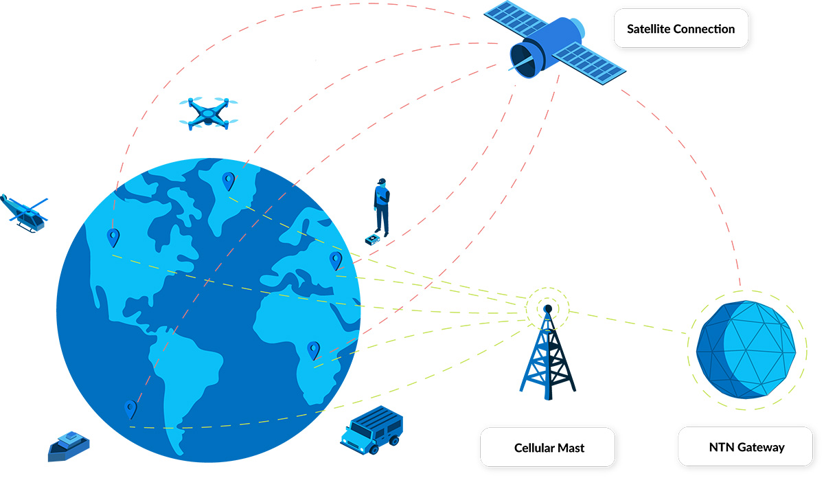
What this means in this context is that a tracking device could use a single SIM to talk to both terrestrial and satellite constellations. There are several benefits from this:
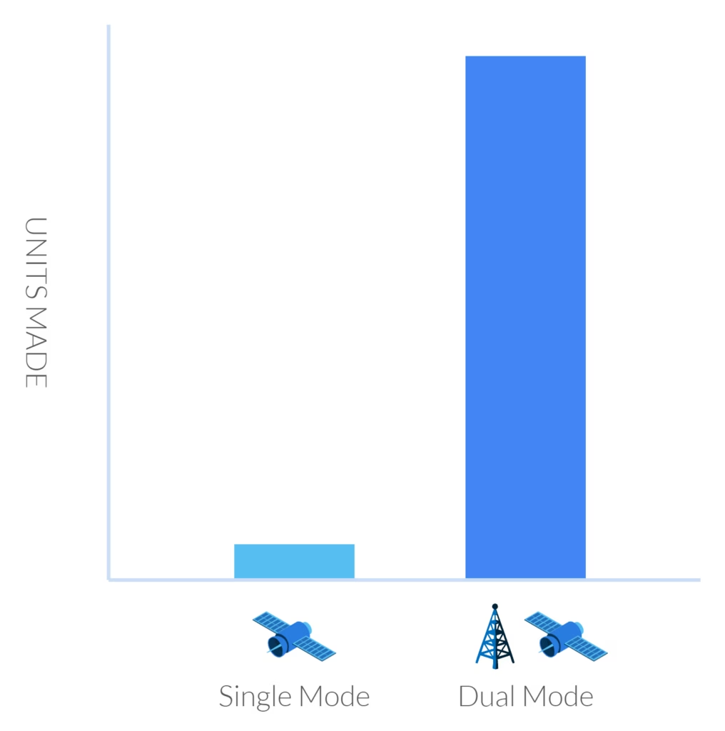
- There are millions more ‘terrestrial’ tracking devices than there are satellite-enabled ones, and because of these economies of scale, they’re generally much lower cost. If these devices are made with the ability to connect to both terrestrial and non-terrestrial networks, these same economies of scale will persist, and the cost of a satellite-enabled tracker will be lower.
- Satellite networks haven’t really, until the advent of 3GPP, had to compete with one another, in the respect that if you want to use satellite connectivity, you need to buy a proprietary modem that communicates with a single satellite network only. Once it’s in place, if you want to change the network, you would physically need to change the modem. But if you have a standards-based SIM, in theory, you can switch your airtime to a different satellite constellation remotely, with the likely impact being that airtime costs will be more competitively priced.
- Data analysis should be simpler; if your tracker is using the same networking language across multiple networks, for example, NB-IoT or LTE Cat-1, the ease with which you can integrate that data with your existing ERP, CRM or inventory management system is greatly enhanced.
Challenges With Implementing 3GPP
There are two ways to enable satellites to ‘speak’ the same language as terrestrial networks. The first is to modify the satellite, and the second is to modify the terrestrial device.
There is a limit to how much modification can be done to satellites that are already in orbit – some as far away as 35,786 kilometers from Earth. So the first option is currently the preserve of companies launching new satellite constellations. The key players here are Starlink, AST SpaceMobile, and Lynk. They are all in the process of launching satellites that are compatible with unmodified LTE-compatible devices. Their largest market is going to be cellphone users, but they’re all anticipating offering an IoT variation; Starlink is likely to be the first to market with this, some time in 2025.
However, they have a key challenge which restricts the global accessibility of these services; they don’t have access to the radio frequencies best suited to IoT and tracking applications. Licensed radio spectrum has been allocated for many years; for satellite network operators it’s called MSS (Mobile Satellite Service) spectrum, and for terrestrial network operators, it’s called MNO spectrum.
In the absence of licensed spectrum, the new satellite network operators have to collaborate with terrestrial network operators to use their spare spectrum. Starlink has agreements with T-Mobile to provide service to the USA, for example, whereas AST SpaceMobile has agreements with AT&T and Verizon. But if your truck or train traveled into Mexico, where Starlink does not, at the time of writing, have an MNO partner, the service would no longer be available.
Given that not all MNOs have spare spectrum – consider Europe and parts of Asia, where networks are already congested – it is unlikely that global service will be available in the next few years.
The second way to implement 3GPP is to update the terrestrial devices that talk to the satellites, and this is the preferred option of the legacy satellite network operators (SNOs). Viasat (previously Inmarsat) and Iridium are the leading SNOs exploring this; they have the advantage of having licensed spectrum, so their services will be globally available from launch.
But, and there’s a big ‘but’ here, they are looking at NB-IoT as their networking language rather than LTE, most probably because it is better suited to existing satellites which weren’t designed for high volumes of high bandwidth traffic. There are far fewer IoT and tracking devices that utilize NB-IoT than there are LTE-enabled devices, so it will take time for the device manufacturers to catch up.
Further, because not all of the satellite network operators have adopted the same networking language, a future in which you can negotiate on price with your SNO because there are several competitors vying for your business is further away.
However, having options to patch the gaps in cellular coverage, particularly as operators are turning off 2G, is a clear positive. If your device has a limited power source – solar or battery – LTE Cat-1 may well not be suitable. So a global in-fill of NTN NB-IoT – which is ideal for low power devices – overcomes the challenge of restricted roaming, and patchy terrestrial LTE-M and NB-IoT.
Where Does Direct-to-Device Come Into Play?
This is sometimes confused / used interchangeably with 3GPP standards-based communication, but it’s not the same thing. D2D refers to the ability for an unmodified terrestrial device to speak to a satellite, but it doesn’t have to be communicating using a standards-based language like LTE or NB-IoT.
The most well-known example of a non-standards-based D2D solution is Globalstar’s collaboration with Apple; Apple updated its handsets to speak to the Globalstar constellation, but they can’t ‘roam’ on to other satellite networks; it’s a proprietary, rather than a standards-based, solution.
Speaking of Proprietary Solutions…
It’s important to stress that proprietary-enabled tracking devices – such as those that use Iridium, Viasat or Globalstar for connectivity – are far from ‘over’. For a start, they already use the most efficient means of communication with satellites, because the devices were designed in conjunction with the satellites. They can send more data, and offer greater flexibility in terms of how that data is transmitted (i.e. IP-based, messages etc.), than standards-based propositions.
Because the narrative around 3GPP standards is chiefly around lower costs, this has already had an impact on satellite connectivity. For the first time, SNOs are enabling their proprietary modems to be incorporated into mass-produced chipsets. This will, through simple economies of scale, lead to a lower price for proprietary modems, making this an increasingly viable option for tracking trucks, trains, ships etc.
As an example, the incredibly small and light, solar-powered and satellite-enabled GSatSolar asset tracking device retails at just $199, with airtime costing <$5 per month (depending on the number of locations you want transmitting).
What Should You Consider for Your Asset Tracking Application?
Firstly, while standards-based devices promise much in the way of cost-savings and ease of implementation, it will be several years before this promise is realized. Mass deployment of devices and adequate supplier competition to influence airtime pricing is unlikely to happen before 2026-27. Further, it’s not clear how the new satellite constellations will overcome their spectrum challenges; although, where there’s a will, there’s usually a way!
In the short to medium-term, the good news is that existing proprietary satellite tracking solutions have, and continue to, come down in price. Our recommendation is to place inquiries and find out what the art of the possible is for your application.
Can we help you with your asset tracking project?
As a company that’s designed and built asset tracking solutions for over 20 years, Ground Control is well placed to help you navigate the dizzying array of options; get in touch – we’re here to help.
Complete the form, or email hello@groundcontrol.com, and we’ll come back to you within one working day.
Satellite-Enabled LPWAN: What Network To Choose, When, and Why
LPWAN – Low Power Wide Area Networks – enable users to connect sensors / endpoints over large distances. They’re lower cost and consume less power than cellular, and while their data capacity rates are lower, there’s enough bandwidth for most IoT applications.
This article focuses on satellite-enabled LPWAN. Satellite comes into the equation when the sensors you’re connecting are so remote there’s no cellular infrastructure at all. At the moment, that leaves you with two options:
- Use an unlicensed LPWAN technology such as LoRaWAN, mioty or Sigfox to connect your sensors, then backhaul the aggregated gateway data via a satellite transceiver;
- Or, connect your sensors individually to a satellite transceiver.
The Differences Between Licensed and Unlicensed LPWAN
Before we settle into the main topic, some readers may find a quick explanation of licensed / unlicensed LPWAN helpful. The former leverages licensed radio frequency spectrum, which means connections use dedicated frequencies, making them more reliable. They also offer higher data capacity rates than unlicensed spectrum. Currently the best known networks – NB-IoT, LTE-M – rely on cellular infrastructure. Because of this dependency, they’re not used for extremely remote applications.
However, satellite LPWAN also falls into this category – services like Iridium’s Short Burst Data (SBD) and Certus 100, and Viasat’s IoT Nano and Iot Pro, all leverage licensed spectrum. Satellite LPWAN has no dependency on terrestrial infrastructure, so is usually deployed where there isn’t any – i.e. outside of population centers.
Unlicensed networks share frequencies with all other unlicensed users, so reliability in high-traffic areas may be an issue. They also have capacity issues because of the frequency spectrum they operate in – which is only suitable for very small amounts of data (LoRa has a maximum data rate of 50 Kbps). However, unlicensed LPWAN is lower cost, and devices generally require a little less power than networks operating in a licensed spectrum, although both perform well. For example, NB-IoT devices will typically operate for up to 10 years, and LoRa devices for up to 15 years, using battery power.
LoRa is the most widely adopted and well known unlicensed LPWAN, but there are many more here, including SigFox, Helium, RPMA and mioty. In the case of LoRaWAN, there are commercially operated networks that you can buy into, or you can set up your own private network.
If you’re in an area with cellular infrastructure, you can weigh up the pros and cons of licensed and unlicensed networks, and choose the solution best suited to your needs from a long list of options. In a remote area without cellular, you’re back to the choice we posed at the beginning: connecting individual sensors via licensed satellite LPWAN, or using an unlicensed LPWAN to aggregate many endpoints, which has no dependency on cellular infrastructure.
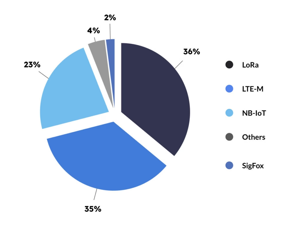
In terms of projected market share, China’s state-wide adoption of NB-IoT makes it the global leader; remove China, however, and the competing technologies are more evenly distributed (data from IoT Analytics). In this chart, which looks ahead to 2027, LoRa is the leader with 36% market share, followed by LTE-M at 35%, and NB-IoT at 23%. LoRa is on the way down from its peak, however, and NB-IoT shows the strongest growth.
How Unlicensed LPWAN Works with Satellite
While there are many options for unlicensed LPWANs, because of its dominance, we’re focusing on LoRa.
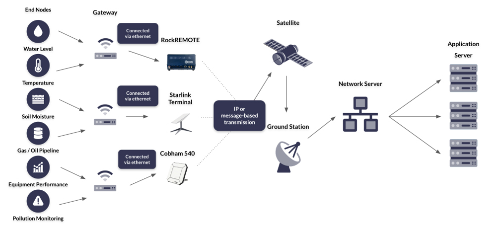
LoRa networks require a gateway, or several gateways, depending on the size of the network, where the sensor data is aggregated. If the gateway is within cellular coverage, cellular can be used for data backhaul, but in remote applications, satellite is the best option for backhauling the aggregated sensor data. Co-locating your gateway(s) with a satellite transceiver like RockREMOTE ensures you can communicate with your sensors from anywhere on the planet, as long as you have a clear view of the sky.
NB: LoRa is a communication technology. LoRaWAN is a media access control (MAC) layer protocol which makes it easier and more secure to manage communication between gateways and endpoint devices (read a better explanation). So while LoRa can be, and is, used without the MAC layer, in the context of a wide area network, LoRaWAN is far more likely to be utilized.
LoRaWAN:
- Has a maximum data rate of 50 Kbps
- Works better for stationary applications
- Works best in open, flat areas such as farmland
- Is license free, therefore low cost
- Drains very little power – battery life can be up to 15 years
- Has strong security measures, with built-in end-to-end AES-128 encryption
- Can be built independently of terrestrial networks and commercial providers
- Works well when gateways are co-located with a satellite IoT transceiver
- Is tried, tested, and in use today for remote IoT applications.
When to use Individually Connected Devices
The main advantage of LoRaWAN is that it’s very low cost, but that cost increases if you’re using a commercially operated LoRaWAN. If you don’t, you’ll need to build the network yourself, which involves purchasing gateways and a network server, writing firmware, and creating the connections (read how to build a private LoRa network).
This could well be worth the effort, but it depends on the number of sensors you’re connecting, and their location. LoRaWAN is a ‘single-hop’ technology; each connected sensor communicates directly with the gateway or hub. If there’s a long distance between device and hub, or there are geographical features like mountains or forests, this can impede the signal. So, there are instances where individually connecting sensors to a satellite modem is faster, more reliable, quite possibly cheaper when time and expertise is factored in, and more efficient.
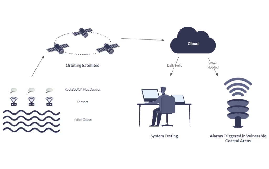
For example, American Signal Corporation has hundreds of tsunami warning stations positioned off the coast of Thailand, to prevent a repeat of the Boxing Day Tsunami that claimed hundreds of thousands of lives.
These stations are located in the ocean, far from cellular infrastructure and mains power, and need to be both completely reliable and able to transmit their data in as close to real-time as possible. The latency and reliability issues of LoRaWAN make it unsuited to this application – as does the fact that some of the sensors are positioned well over 10 km apart.
Instead, each station has its own satellite transceiver – the RockBLOCK Plus – which uses the Iridium Short Burst Data airtime service. This checks all the boxes: it’s a low cost, low power, reliable, low latency means of transmitting data from anywhere on Earth with a clear view of the sky.
This solution is being used in many scenarios like this where the data must get through, and there’s no cellular infrastructure, and building a LoRa network (or similar) would be cost and/or time-prohibitive.
Satellite LPWAN:
- Works well in both mobile and stationary applications
- Has no limitation on the distance between your sensors – they can be positioned as far apart as your application requires
- Has a huge amount of flexibility in terms of data rates – up to 464 Kbps (although the lowest power consumption comes from the message-based services of Iridium Short Burst Data, and Viasat IoT Nano)
- Can operate on a solar powered battery for 10 years (depending on data rates and frequency of transmission)
- Is secure by design – it’s very hard to intercept the data while it’s in space, and firewalls, VPNs and private lines protect the data once it’s earth-bound again
- Has no dependency on terrestrial infrastructure
- Will work in any location, including mountains and forests, as long as there is a clear view of the sky
- Is not affected by extremes of temperature or adverse weather conditions.
Coming Soon: NTN NB-IoT
This is developing technology, with the goal of offering a single SIM to work on multiple cellular and satellite networks.
While the technology exists today to seamlessly switch between cellular and satellite networks, the devices enabled with this technology are using proprietary modems that only communicate with a single satellite network. Relatively few are produced, and they’re more expensive than their cellular-only counterparts. Moreover you’re tied into that satellite network, and if you wanted to use an alternative satellite network, you would need to buy a completely different device.
3GPP standardization is poised to disrupt this model. Firstly, there are many more cellular IoT-connected devices than there are satellite IoT-connected devices, and so production of these dual-function modems would benefit from economies of scale. They are likely to be lower cost than today’s proprietary satellite IoT modems.
The other potential benefit will be the ability to switch between satellite network operators in much the same way as you can switch between cellular networks today. Every satellite network that is 3GPP compatible with coverage in your area should be able to offer you service. It’s by no means certain, but we think this is likely to increase competition and lower pricing.
So, the impact will be to make NTN NB-IoT not just possible but also cost-competitive over the long term. That said, it will still be a more expensive solution than an unlicensed LPWAN – and for good reason, as it retains the higher data capacity rates and reliability benefits of licensed spectrum.
The lower cost modules may well move the tipping point between individually connected endpoints / sensors vs. building a LoRa network. Individually connected endpoints, as we’ve already discussed, have the benefit of being easy to set up, reliable and low latency. The number and location of the endpoints determine the choice of network today, and that will be true with NTN NB-IoT, too. But as the cost will be lower, the point at which it makes sense to use LoRa (or similar) will, we anticipate, come at a higher number of endpoints than it does today.
It may also open up new use cases for geographically dispersed endpoints that could utilize satellite IoT today, but the proprietary modems make this cost-prohibitive. Applications in Agriculture, Utilities, Mining and Oil & Gas are likely to emerge as the device and airtime costs decrease.
NTN NB-IoT:
- Has a maximum data rate of 159 Kbps up, 106 Kbps down
- Works well for stationary and slower-moving mobile applications
- Offers greater reliability as the network is more exclusive
- Strong support for user identity confidentiality, authentication and integrity
- Doesn’t require a gateway, but you will need – once available – a dual mode satellite and cellular SIM card in each device
- Will no longer need terrestrial cellular infrastructure once Satellite Network Operators (SNOs) make their satellites compatible with the 3GPP standard
- Should support route switching in the future, keeping costs low and predictable.
What is 3GPP?
3GPP is a global initiative to basically stop telecommunication infrastructure developers from all doing their own thing. Since 1998, they’ve successfully driven standardization across cellular development. Release 17, in 2021, included satellite connectivity to the technology mix for NB-IoT delivery – often referred to as NTN (non-terrestrial network).
If an orbiting satellite network meets the 3GPP standard, someone, or something, on Earth that has a similarly 3GPP-compliant modem in their device could pass out of cell tower range, and immediately switch to satellite, with no interruption of service, and no need for separate hardware. All the excitement about direct-to-device technology stems from this, but “Rel-17” also unlocks NB-IoT’s use in extremely remote locations, with satellites performing the task of cell towers.
What About Non-Terrestrial LTE-M?
LTE-M is, like NB-IoT, a licensed LPWAN designed to operate on cellular networks. It’s a little more expensive because it offers higher bandwidth transmissions, and supports roaming: it was designed to work for mobile and fixed IoT applications, vs. NB-IoT that is best used in fixed IoT applications. Both are part of the broader 3GPP standard, and so the structure exists to use satellites to perform the role of cell towers in space.
At the time of writing, the satellite network operators moving the fastest towards NTN architecture are using NB-IoT as their preferred technology. However, Starlink will use a form of LTE when it brings an IoT proposition to market, and other satellite network operators may well follow suit.
What’s Best for Your Remote Application?
There is a lot of hype around 3GPP standards-based technology, and when it comes to fruition, users will benefit from lower cost modems and possibly, because of increased competition, lower cost and more predictable airtime bills. Many major satellite network operators – Iridium, Inmarsat, Viasat, Starlink – have announced plans to support a form of this technology (either NTN NB-IoT or LTE) in the future.
There are companies already offering this service, but at the time of writing, they have patchy coverage, and data capacity rates are very low. The full value of this technology will be realized when there is global availability and multiple service providers – which is currently looking like 2026-27.
If you’re building your remote application right now, your choice of LPWAN depends on your application. If your devices are very widespread, LoRaWAN may not be your best choice given the higher risk of packet loss between the sensors and the gateway(s). It is cost-effective, particularly when paired with a satellite transceiver like RockREMOTE which supports edge computing, thus allowing you to optimize your transmissions. If you can manage with a degree of data delivery uncertainty (due to the capacity challenges in the unlicensed radio frequency spectrum), it’s a good choice.
For devices spread over a wide geographical area, connecting each sensor or sensor array to a satellite IoT transceiver ensures that you will receive your data, with no dependencies on terrestrial infrastructure, and no reliability issues due to contested spectrum. If you choose a service like Iridium Short Burst Data, or Viasat IoT Nano, you’ll receive your data in close to real-time, too. Connecting sensors in this way costs more, but even now is less expensive than people imagine. For mission-critical applications, it’s the most reliable, fast and secure means of capturing your widespread remote sensor data.
Can we help you with your remote application?
If you’re connecting endpoints in remote locations, we hope you’ve found this article useful. We are experts in satellite connectivity, and work with multiple satellite network operators to ensure our customers get the best combination of coverage, reliability, price and latency.
If you’d like to speak to one of our team, please complete the form, or email hello@groundcontrol.com. We’ll come back to you within one working day.
Unlocking the Full Potential of IoT: How Satellite Modules are Redefining Connectivity
Satellite IoT modules are transforming the way companies interact with their customers, increase operational efficiency, and gain insights into their business operations. Delivering truly global, reliable coverage, these modules enable organisations to unlock the full potential of the Internet of Things (IoT).
The latest research from IoT Analytics estimates that by the end of 2023, the IoT will be responsible for 16 billion active devices. But given the importance of reliable connectivity, how many of these devices will be satellite-enabled?
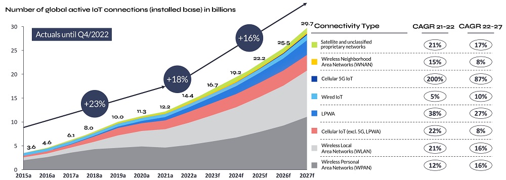
Source: IoT Analytics Research, State of IoT 2023
Note from authors: IoT connections do not include any computers, laptops, fixed phone, cellphones, or consumers’ tablets. Counted are active nodes/devices or gateways that concentrate the end-sensors, not every sensor/actuator. Simple one-directional communications technology not considered (e.g. RFID, NFC). Wired includes ethernet and fieldbuses (e.g. connected industrial PLCs or I/O modules); Cellular includes 2G, 3G, 4G, 5G; LPWA includes unlicensed low-power networks; WPAN includes Bluetooth, Zigbee, Z-Wave or similar, WLAN includes Wi-Fi and related protocols; WNAN includes non-short-range mesh, such as Wi-SUN; Unclassified proprietary networks include any range.
As you might expect, IoT connectivity continues to be dominated by Wi-Fi, Bluetooth and cellular IoT. But interestingly, the CAGR for each of these is predicted to decrease, in some cases significantly (cellular from 200% to 87%) by 2027. In contrast, satellite IoT connections are projected to grow from 6 million to 22 million (at a CAGR of 25%).
What are satellite IoT modules?
Satellite IoT modules or modems are specialised hardware components that enable devices to communicate with satellites and access global connectivity. These modules are designed to be power-efficient, compact, and compatible with existing IoT device architectures. Typically they are used in areas of IoT networks where traditional cellular networks or other forms of terrestrial connectivity are either unavailable or unreliable, such as remote or rural areas.
How do they work?
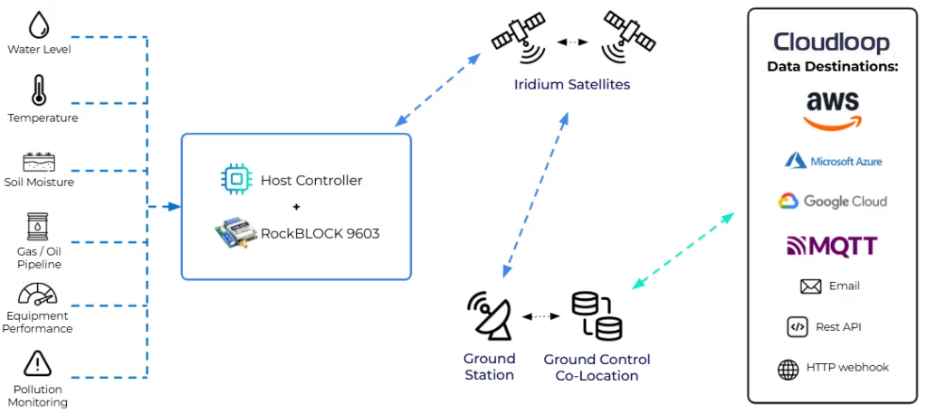
Simply, satellite IoT modules work by leveraging satellite networks to establish communication between IoT devices and the central infrastructure.
IoT devices such as sensors or trackers are equipped with satellite modems (e.g. the RockBLOCK) that transmit data to satellites orbiting the Earth. Data is sent to a satellite, in this case a satellite within Iridium’s constellation, the satellite then relays the received data down to the ground station.
The ground station serves as a gateway to bridge the communication between the satellite and the Network Operations Centre (NOC), forwarding the data on to the appropriate destination. This can be a cloud platform, a server, or any designated system that collects and manages the IoT data.
How do satellite and terrestrial IoT modules compare?
Terrestrial and satellite IoT modules share many similarities. They both offer the necessary connectivity and processing power for devices to exchange data and come in multiple form factors depending on the deployment requirements. From PCBs intended to be built-in to the sensor array, to fully ruggedised and waterproof devices with integrated processing, storage and security features.
What’s more, all IoT modems require an antenna, the size of which will depend on the signal strength needed. Satellite IoT devices can have surprisingly small antennas if the orbiting satellite service operates in a high frequency, like Iridium (see the patch antenna on the RockBLOCK 9603, which measures just 25 x 25 x 4mm). Other satellite network operators leverage lower frequencies, which require larger, external antennas – Swarm, for example, needs a 20cm antenna to communicate with its satellites.
Terrestrial and satellite IoT modules also exhibit distinct differences that set them apart:

Connectivity Coverage
Satellite IoT modules use satellite networks to provide connectivity, whereas other IoT modules typically rely on cellular networks, Wi-Fi, or other forms of terrestrial connectivity. This allows devices equipped with satellite IoT modules to communicate from virtually anywhere on the planet, even in areas with limited or no cellular coverage.

Module Cost
Satellite IoT modules can be more expensive than other IoT modules due to the specialized hardware and software required to enable satellite connectivity. However, as the technology matures and the demand for satellite IoT applications grows, costs have already, and are likely to continue to, come down.

Communication Latency
Due to the time taken for signals to travel to and from satellites in space, satellite IoT modules can experience higher latency than their terrestrial counterparts. However with Low Earth Orbit (LEO) satellite constellations, for example Iridium, latency can be less than one second, providing high-quality, low-latency communication.
Further benefits to Satellite IoT
Security and Data Privacy
Satellite IoT networks employ robust security measures to protect data transmission and ensure privacy. Encryption and authentication protocols are implemented to safeguard data integrity and prevent unauthorised access. Firewalls and VPNs are leveraged when data travels over public infrastructure like the internet, but this can be completely circumnavigated with either private lines or a private satellite network like TSAT.

Reliable and Resilient
Satellite networks are designed to be highly reliable and resilient. They are less susceptible to environmental factors, natural disasters, or infrastructure failures that can disrupt terrestrial networks. Typically offering high reliability and uptime, satellite IoT ensures consistent data transmission and device communication even in challenging and remote environments.
Scalability
Satellite IoT networks offer scalability to accommodate a large number of connected devices. Businesses can scale their IoT deployments without concerns about network capacity limitations or infrastructure upgrades. This scalability is crucial for projects that require the connection of a large number of sensors, devices, or assets spread across vast areas.

Rapid Deployment
Satellite IoT modules enable rapid deployment, especially in remote or temporary setups. They eliminate the need for building new terrestrial infrastructure or relying on existing networks. Companies can quickly establish IoT connectivity in remote or disaster-stricken areas, facilitating faster response times and data collection.
The Future of IoT modules
The previously mentioned research from IoT Analytics, also noted that the integration of satellite connectivity options into LPWA chipsets, spearheaded by companies like Qualcomm, has the potential to accelerate the adoption of hybrid IoT devices. Sony Semiconductor has already introduced ALT1350, the first cellular IoT LPWA chipset with satellite connectivity, expanding the communication capabilities of IoT devices beyond conventional network limitations. This significant development paves the way for new possibilities in the IoT landscape. By incorporating satellite connectivity into LPWA chipsets, further innovation and growth are projected. Until then however, the combination of satellite and terrestrial networks still delivers organisations the flexibility to realise the full potential of their IoT deployments.
Choosing the right Satellite IoT modules
The majority of satellite IoT modules are proprietary technology. Simply, they are designed to leverage a specific satellite network, for example, Viasat, and often a specific airtime service, for instance, IoT Pro. As each satellite network offers different coverage, reliability, latency and so on, and each service allows different data rates, message sizes and more, its key companies evaluate their connectivity needs thoroughly. Satellite connectivity can be expensive (see our post on how to reduce satellite connectivity costs), so typically businesses will only use this for areas of their IoT network where they are struggling with connectivity, or for the purposes of failover or backhaul. In any case, businesses should assess their data transmission requirements and select the most appropriate satellite airtime service for their application, before considering their hardware options.
If you do have any specific queries related to airtime, please don’t hesitate to get in touch. We’ve been doing this for over 20 years and though we have significant relationships with both Iridium and Viasat we’re not tied to any one provider, just helping you find the best solution for your project and budget.
Once companies have selected their preferred airtime service, it’s important to consider the interfaces and integration options provided by the satellite IoT modules. It is important to determine if the modules support the necessary interfaces (e.g., UART, SPI, I2C) for seamless connectivity with IoT devices or sensors. Additionally, assessing compatibility with standard IoT protocols (e.g., MQTT, HTTP) is vital to ensure smooth integration within your existing IoT infrastructure.
Another aspect that businesses need to assess is the size and form factor of the satellite IoT modules. Consider any space limitations, weight restrictions, and physical constraints that may be relevant. For instance, if your application requires burying sensors or housing them within an enclosure, antenna options must be considered. Depending on factors such as the enclosure material, an external antenna may be required to enhance signal strength. This improves communication reliability and can help facilitate clear line-of-sight with geostationary satellite networks.
Moreover, companies must verify that the satellite IoT modems comply with relevant certifications and regulatory standards applicable to their target markets. Compliance with certifications like FCC, CE, and RoHS ensures adherence to quality, safety, and environmental standards. For those with deployments spanning larger geographical areas, it’s prudent to ensure that there are no local restrictions for satellite connectivity; some countries such as India restrict use without prior government approval.
Additionally, it is important to assess the cost considerations associated with the satellite IoT modules. This includes evaluating module pricing, airtime costs, and any additional fees or licensing requirements. Considering the total cost of ownership over the desired lifespan of the IoT project will provide a comprehensive understanding of the financial implications.
Finally, though satellite IoT modules are designed to be power efficient, it is necessary to evaluate power consumption. Depending on the deployment scenario, it might be worthwhile to consider modules that can leverage alternative power sources such as solar power, like the Iridium Edge Solar.
By carefully considering these factors, companies can make informed decisions when selecting satellite IoT modules, ensuring optimal integration, performance, and cost-effectiveness for their specific IoT projects.
Overall, satellite connectivity is a game-changer for IoT, enabling devices to operate in previously unreachable areas and opening up new possibilities for businesses and industries. By choosing the right satellite IoT module and airtime service, businesses can unlock the full potential of IoT and drive innovation in their respective fields.
Unlimit your IoT deployment today
As industry leaders that have been designing and manufacturing satellite devices for over 20 years, with strong partnerships with top satellite providers like Inmarsat and Iridium, we have the expertise, experience, and access to competitive satellite airtime rates to make your IoT initiatives a success.
Don’t let geographical limitations hold back your IoT ambitions. Let our team of experts guide you towards achieving your goals. Fill in the form below and take the next step towards unlocking the full potential of your IoT project.
The Role Of 5G And Satellite Technology In Industry 4.0
Industry 4.0, alias, Fourth Industrial Revolution, describes the integration of advanced technologies such as the Internet of Things (IoT), Artificial Intelligence (AI) and robotics, quantum computing, genetic engineering and more. It represents a shift to a more connected world, whereby the lines between the digital and physical are blurred.
Also referred to as Smart Industry, Industry 4.0 is transforming businesses, enhancing and optimising operations with real-time monitoring and control, and enabling new business models, for example, mass customization.
Cisco’s Annual Report predicted there would be almost 30 billion connected devices by 2023 and Statista estimated 15.1 billion would be IoT connected devices. Though we are still scratching the surface of the possibilities open to us as a result of IoT and Industry 4.0, more generally, all of these technologies and outcomes are dependent on connectivity. Without connection, the insights available via data transmission and analysis remain elusive.
Meeting the demands of a connected world
In order to support this increasingly connected world, governments and organizations have largely focused on building out high-speed broadband networks, expanding wireless coverage and investing in smart city infrastructure. Though some parts of the globe have made significant progress, not least those in developed countries, there are still substantial gaps. At the beginning of 2023 it was estimated that just 64.4% of the global population had access to the internet.
In November 2022, the UK government pledged £5 billion to deliver gigabit-broadband to a minimum of 85% of premises by 2025 and the original target of ‘nationwide’ was pushed back to 2030.
The role of 5G in Industry 4.0
5G’s role in the future of Industry 4.0 is significant. 5G enables a much larger number of connected devices to operate simultaneously, with faster response times and higher levels of reliability. This is particularly important for IoT applications that require real-time data processing, such as smart city infrastructure.
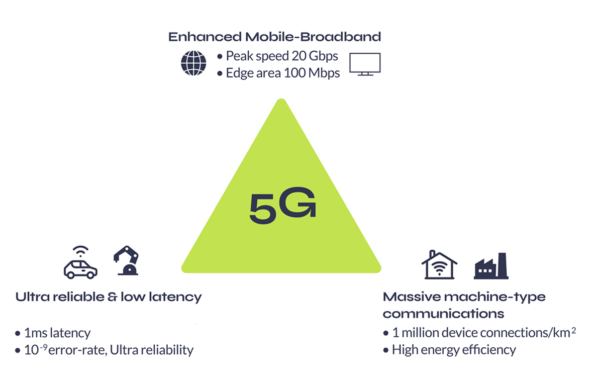
The 5G triangle represents the full spectrum of capabilities, from high speed data transfer to low latency connectivity for mission critical applications, and efficient connectivity for the large number of IoT devices that will be connected to the network.
1. Enhanced Mobile Broadband (eMBB)
Fast data transfer, low latency
Data transfer speeds up to 20 Gbps and latency as low as 1 millisecond
Use cases: High bandwidth applications, for example, video streaming and virtual reality.
2. Ultra-Reliable Low Latency Communication (URLLC)
Low latency, high reliability
Latency as low as 1 millisecond and reliability of up to 99.999%
Use cases: Mission-critical applications such as autonomous vehicles.
3. Massive Machine-Type Communication (mMTC)
Low power, low bandwidth
Designed to support up to 1 million devices per square kilometre
Use cases: Applications with a high volume number of devices. For example, automated supply chain management, infrastructure for smart cities.
In addition, 5G can help to address some of the key challenges facing IoT, such as security and privacy, by providing more robust and reliable connectivity.
However, though 5G is capable of delivering broadband across short distances, it was designed to enhance coverage in urban regions with dense populations – not for rural, remote areas. 5G is currently sitting at an 8% global adoption rate, with terrestrial networks more widely covering just 15% of the globe. It’s clear telecommunications infrastructure alone cannot support this new, interconnected world.
As Tom Stroup, President of the Satellite Industry Association explains – “We’ve seen a recognition that many of the things that are desired by 5G can only be achieved with the ubiquitous coverage that satellite networks provide.”
The future of 5G: Satellites
Though connectivity is about more than coverage, one of the primary benefits of leveraging satellites in 5G networks is 100% global coverage. Unlike traditional mobile networks or fibre connectivity which rely on infrastructure, satellites can provide coverage anywhere and everywhere on Earth.
Another advantage is that Low Earth Orbit (LEO) satellites can deliver low latency, high speed connectivity. Latency is an important consideration for time critical applications such as remote surgery or autonomous vehicles where delays could lead to severe consequences. As LEO satellites are positioned between 160 – 2,000km (99 – 1243 miles) from the Earth’s surface, latency can be as low as 20 milliseconds which is comparable to that achieved via terrestrial networks. Moreover, the additional bandwidth would place 5G networks in the best possible position to accommodate ever increasing data traffic and number of connected devices.
Ultimately satellites could be used to complement 5G networks in three main ways:
- Expanding coverage to include rural, remote areas,
- Creating redundancies, and
- Additional backhaul.
Though it’s likely the role of satellites will look slightly different depending on the country and region and thus bandwidth and coverage already available, if successful these could lead to several additional business models.
But the how is slightly more complicated. Interoperability isn’t a new conversation within the communications industry but it wasn’t until 2017 that a formalized working group recommended 5G technology should be able to integrate non-terrestrial networks (NTN) such as fibre and satellites. Fast forward to July 2020, 3GPP Release 16 began to address this challenge.

What is 3GPP?
The Third Generation Partnership Project (3GPP), is a collaboration between various telecommunications standards organizations. The main focus of the 3GPP is to develop specifications for wireless communication systems, including 2G – 5G technologies. These specifications include protocols for cellular networks, as well as guidelines for interoperability between different devices and networks, including non-terrestrial networks.
3GPP Release 16: Benefits and shortfalls
Release 16 outlined multiple significant improvements not least, access technology standards for using higher frequency New Radio, supporting greater signal bandwidth and lower latency. Of those relating to interoperability, dual connectivity was extended to support NTN. Meaning in theory satellites could connect assets in rural areas where cellular coverage was limited and integrated access and backhaul was named as an area of study.
Despite these improvements, there were some associated shortfalls. One of the main challenges with 5G over satellite is latency. While as previously mentioned, Low Earth Orbit (LEO) satellites can achieve latency times as low as those associated with cellular, this isn’t always possible.
For geostationary (GEO) satellites, which are located roughly 34,000km above the Earth’s surface vs LEO’s 160 – 2,000km, the round-trip time is longer; closer to 270 – 540 milliseconds. As Release 16 didn’t account for this, it meant satellite operators needed to develop their own solution to mitigate potential latency issues.
What’s more, Release 16 didn’t account for mobility issues. This is more applicable to LEO satellites as these networks create a mesh of satellites around the globe and pass data as required between satellites and various ground stations. Particularly in the case of asset tracking applications where assets are moving, mobility and thus handing data from one satellite to another, becomes more important.
While Release 16 defines the interfaces between the UE and the core network, it does not provide detailed guidance on how to handle handovers between terrestrial and satellite networks. This can result in disruptions to the user experience as the UE moves between different network environments.
Ultimately Release 16 highlighted the importance of collaboration. Just one great example formed following Release 16 is that between Inmarsat and MediaTek in late 2020.

Their collaboration involved a successful field trial which ultimately contributed to 3GPP’s Release 17 standardization work on NTN. Utilising NB-IoT technology, a bi-directional link from MediaTek’s satellite-enabled narrowband service to Inmarsat’s Alphasat L-band GEO satellite was established. As Jonathan Beavon, Senior Director at Inmarsat concluded – “testing MediaTek’s standard NB-IoT chip over Inmarsat’s established GEO satellite network has proven technology from mobile networks works effectively over GEO satellites with little modification and will provide a very cost effective path to ubiquitous and hybrid global IoT coverage.”
Release 17
In 2022, 3GPP Release 17 marked the most recent standard for 5G Networks and was the first to outline technical specifications for direct-to-device 5G over satellite.
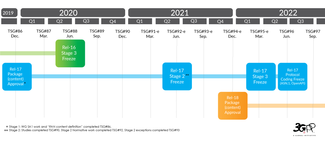
Specifically addressing interoperability, Integrated Access and Backhaul (IAB), and network slicing were extended to support NTN. The former, IAB, is particularly relevant for satellite operators as it helps address issues associated with latency by providing a more direct connection between device and satellite. Network slicing on the other hand is best exemplified by applications such as smart cities. Network slicing enables specific applications within the wider smart city network to utilize allocated network slices. So in the case of traffic monitoring and management, prioritising the utilization of a low latency, high bandwidth network slice ensures this application is better supported.
Release 17 also included additional features for dual connectivity. These cover support for more advanced network slicing configurations, which can help to improve the efficiency of network resources.
Moreover, Release 17 outlined enhanced support for Low Earth Orbit (LEO) satellites. Mobility issues were addressed by new features such as satellite handover, enabling seamless connectivity as devices move from one satellite to another.
The future of wireless communications
Release 17 was the first to position satellites as a critical component of the 5G ecosystem. Though this is a significant step forward, introducing new technology into any architecture is not something which can be achieved overnight and in the case of satellites, there are two relatively large challenges to integration: regulatory and capital. There may be regulatory issues related to spectrum allocation and licensing and there are well documented business challenges related to the cost of deploying and operating satellite networks.
In the case of satellites, it’s not quite as simple as changing a SIM or updating firmware over the air. Satellites are largely programmed prior to launch. In most cases it would mean launching additional satellites within a constellation to add the technology required to support these interoperability features.
If for example, satellite operators had incorporated 2G or 3G network technology, both of which are now in the process of sunsetting, those additional features would be becoming redundant. In short, there are benefits to maintaining proprietary technology and this is how many of the longer standing satellite operators have conducted business.
Currently many of the in-built phone functions depend on 5G NTN technology. However, despite the noise the reality of integration is slow. Qualcomm’s new Snapdragon X75 chipsets, leveraging Iridium’s satellite network are due for sampling in Q2 of 2023 (now), with expected select shipping estimated for Q3 and 4. Other companies, including Apple have demoable tech which incorporates NTN using Qualcomm X65 chipsets but this is limited to one usable band – n53.
In short, while advances are exciting and once this tech does land it’s expected to be very disruptive, we are still very much in the early stages of development. So the exact role of satellites within 5G architecture and Industry 4.0 more generally is unclear.
What is clear however, interoperability is top of mind for many just now. Just this week, 13th March 2023, Iridium’s CEO Matt Desch hosted a session at the SATELLITE 2023 event titled The Satellite-Cellular Convergence – A New Era for the Telco Industry?
The last few years within the satellite industry has seen incredible growth and innovation but not all new players entering space will be here for the long term. Just as not all technology within the 3GPP standard – NB-IoT (Narrowband Internet of Things), LTE-M (Long-Term Evolution for Machines), 5G NR – will be here for the long term. The challenge now lies with satellite operators and bodies such as 3GPP to create and maintain technology standards which all players can bet on. Ultimately, the only way we will achieve a fully connected world capable of supporting Smart Industry is with both 5G and Satellite technology because without connection, nothing is smart.
Ready to unlimit your IoT application…
… But not sure where to start? We can help. Interoperability can be a real challenge for those with IoT projects. Having partnered with satellite network providers such as Iridium and Inmarsat for well over a decade, we have access to competitively priced tariffs, and almost all of our products allow dual connectivity.
So if you are working on an IoT project and would like some no pressure, objective advice, simply fill in the form and one of our expert team will get back to you.
How Satellite IoT Closes The Gap in Remote Wind Turbine Data Monitoring Challenges
The renewables landscape is changing. The International Energy Agency (IEA) reports that the ‘global energy crisis has triggered unprecedented momentum behind renewables, with the world set to add as much renewable power in the next 5 years as it did in the past 20’.
The rise of renewable energy and the pitfalls of unplanned maintenance
Partially due to Russia’s invasion of Ukraine, countries are increasingly motivated to invest in renewable energy technologies to reduce reliance on imported fuels. Wind and solar energy in particular will account for over 90% of the renewable power capacity that is added globally over the next five years, according to the IEA.
So what does this mean for wind power in Europe?
Solar and wind power generated more than a fifth (22%) of its electricity in 2022, pulling ahead of fossil gas (20%) for the first time, according to the European Electricity Review 2023. However, many wind farms are located in remote areas and have limited resilience against severe weather, power outages and downtime due to unplanned maintenance.
In the case of the latter, often, renewable energy providers rely on physical onsite maintenance to restore energy production, requiring significant resources, time and cost. It presents energy providers with a big challenge. Research by Wood Mackenzie Power into renewables in 2019 found that $8.5 billion was spent on unplanned repairs and corrections caused by component failures in wind operations.
This cost could be lowered and potentially avoided if sensors for predictive maintenance were operable, and the data generated is available consistently and in close to real-time. It’s an area where satellite IoT connectivity makes economic sense.

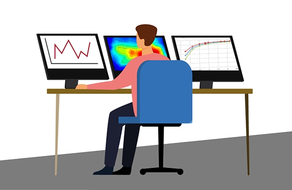
How SCADA data helps keep the turbines turning
For each wind farm – onshore or offshore – SCADA (supervisory control and data acquisition) data is reported. This includes weather data such as wind direction, various turbine parameters, and errors encountered by the system, normally at 10-minute intervals.
It’s this historical SCADA data that provides invaluable insights to generate a robust approach to monitoring turbine performance, identifying patterns and predicting failures for better predictive maintenance planning and less downtime. Via satellite-driven data monitoring, renewable data intelligence is delivered in seconds. This enables engineers, maintenance managers and data scientists the ability to plan, predict and act to close the gap in remote wind turbine data monitoring challenges.
Why there’s a better way than cellular, fiber and onsite personnel
Unlike cellular and fiber connectivity – which in many cases is not a feasible solution due to the remote locations of wind farms – satellite IoT is truly global. Satellite connectivity ensures reliable remote data monitoring from individual turbines to entire wind farms allowing optimization and ongoing performance assurance of wind energy output.
IoT Pro terminals (previously known as BGAN M2M) are designed to connect monitoring and control applications in remote, unmanned locations like wind farms, to provide visibility and management of those assets. Remote management of the terminal can be achieved via SMS, eliminating the reliance on on-site maintenance crews, mitigating unplanned downtime and saving costs.
As an example, an experienced Field Engineer has a day rate of approx. 350 euros plus fuel, company vehicle maintenance and overtime. In contrast, the cost of operating a Viasat-enabled satellite connectivity terminal can be as little as 60 euros per month for up to 20MB; not only is this a clear saving over physically sending an engineer into the field, the data is available in close to real-time, all the time.
SCADASat by TSAT enables renewable providers to cost-effectively and reliably transmit remote SCADA, telemetry and M2M data – all in a secure network. The platform is highly scalable with low operating costs compared to the new installation and maintenance of fiber connectivity. It is compatible with both IP and legacy serial devices and operates independently from terrestrial communications systems, both complementing and offering an alternative solution to terrestrial networks, ensuring transmission at all times.
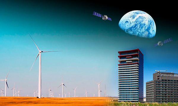

How satellite IoT closes the gap with IoT Pro
Operating on both Viasat IoT Pro and cellular 2G/3G/LTE networks, these devices keep data flowing to enable predictive maintenance.
While wind farm resilience against severe weather will continue to be tested, the challenges of power outage predictions and production downtime due to unplanned maintenance can be solved via the adoption of IoT Pro solutions.
How we can help overcome your data monitoring challenges
Ground Control can solve renewable energy monitoring challenges with satellite IoT. We help our customers achieve an accurate, real-time, 360 view of their data and operations; anywhere and everywhere. If you’d like some impartial advice on the best device and airtime for your data monitoring requirements, get in touch. With 20 years’ of experience, we’re confident we can help.
Would you like to know more?
We’re here to help. With highly experienced staff based in the UK and USA, we’re here to talk through your most challenging remote connectivity requirements.
Complete the form, or if you prefer to speak to someone directly, call us on +44 (0) 1452 751940 (Europe, Asia, Africa) or +1.805.783.4600 (North and South America).
The Dejero GateWay: Combined Cellular And Satellite Airtime Service For The Toughsat
The Toughsat Auto Deploy Antenna is already established as a reliable, robust mobile satellite system – and we’re pleased to announce that we have secured an even more robust and cost-effective connectivity solution to accompany this. In addition to our Dual Matrix satellite service, we are now able to offer Ground Control customers an enhanced connectivity service via The Dejero GateWay. Utilizing Smart Blending Technology, the new service seamlessly blends multiple cellular and satellite networks into one pipe, resulting in better cost management and often, faster download speeds.
Used to facilitate phone and internet, in any location, our SAFECOM-compliant Toughsat series has proved particularly popular among First Responders, those with off-grid operations and for the purposes of disaster recovery.
As the world continues to become more interconnected and mobile, organizations and companies are increasingly turning to cloud-based solutions to support operations. In addition, many have become reliant upon autonomous data transmission, to drive and maintain operational efficiencies. For both, reliable connectivity is key. And for many, this connectivity is mission critical.
The Dejero Gateway
In simple terms, The Dejero GateWay is a certified, network aggregation device that uses Smart Blending Technology. We have been strengthening our Cell/Sat service across North America, and this enhanced cellular/satellite hybrid is now available to our Toughsat customers.
What is Smart Blending Technology?
Dejero explains, we “simultaneously blend together multiple wired (broadband, fiber) and wireless (3G/4G/5G, Wi-Fi, satellite) IP connections from multiple providers to form a virtual Dejero ‘network of networks’.
We dynamically and intelligently manage the fluctuating bandwidth, packet loss, and latency differences of individual connections in real-time.”
How does this help Ground Control customers?
We understand our customers require ubiquitous, powerful connectivity, under all circumstances. Especially in the case of First Responders, where real-time information is required to deliver situational awareness to both command center and teams on the ground. Many use cases also call for video streaming, which can prove challenging depending on the required bandwidth and speed of connection available.
With this new service, we can offer our customers ubiquitous, powerful connectivity, utilizing more cellular networks, meaning better cost management. And in some cases, as multiple cellular networks are simultaneously combined to deliver one robust connection, increased speeds. We recently ran our own tests utilizing our Toughsat XP and The Dejero Gateway, and saw download speeds over 180Mbps.
As an example, with a Dejero M6E6 GateWay device, we would provide SIMs on Verizon, AT&T and T-Mobiles networks (2 SIMs on each) and the Toughsat would use a Cat-5 to plug into the External WAN port on the Dejero. Any cellular and satellite service that the device can see would be blended/bonded together to deliver one usable, more robust internet connection. For instance, if the cellular networks seen, totalled 100x10Mbps, and the satellite was receiving 20x5Mbps, you would achieve speeds of 120x15Mbps.
What’s more, as the service plans assume some usage is going to be over cellular, after the hardware, airtime plans could drop by up to 30% over standard usage services.
At Ground Control, we have always aimed to optimize our customer’s connectivity, so data always gets through, and in the most cost-effective way. We are genuinely excited to see what this new service can provide for our customers.
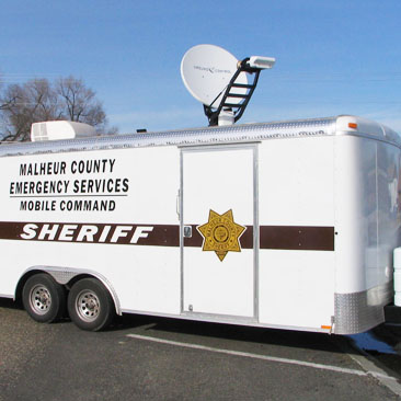
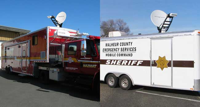
The Toughsat XP is an auto-pointing VSAT satellite dish that’s available in different sizes and configurations. It is the only VSAT antenna listed by make and model in the US FEMA Cache list. The Toughsat delivers broadband internet speeds of 20 Mbps up and 5 Mbps down with our network service. Built for extreme weather, temperature and high winds, the range is very popular with emergency personnel.
Our complete systems are trusted by hundreds of Urban Search and Rescue agencies, State, County and City Law Enforcement and Fire Departments throughout the United States.
If you would like any further information, on our products or available airtime services, simply get in touch with our expert team at hello@groundcontrol.com.
Can We Help?
With over 20 years experience facilitating emergency preparedness and response across the globe, we understand that in a crisis, every second counts. We’re constantly evolving and adapting our Public Safety offer and systems to best support teams on the ground. Which is just part of the reason Ground Control has been a trusted name in Emergency Responder satcom since 2002.
Whatever your communication or connectivity needs, we can help.
Six Ways Asset Tracking Can Help Reduce Costs and Wastage in the Supply Chain
According to the BSI and TT Club’s Cargo Theft Report 2021, the top countries for cargo theft are Brazil, India, Mexico, Germany, Russia and the United Kingdom. By far the most common form of theft is to hijack trucks or otherwise force entry into containers while in transit; at 71%, this eclipses thefts from facilities (25%).
Road freight crime cost the UK economy £250 million in 2020 – a 113% increase on 2018 data – and the UK also holds the dubious honour of hosting the largest theft in EMEA supply chains: £7.5m worth of computing equipment was stolen from a truck in Nuneaton in the West Midlands in March 2020.
In addition to theft, there is a growing problem of individuals stowing away in cargo shipments, which increases insurance costs, and can result in loss of goods. To round off our trifecta of supply chain issues, we have perishable goods failing to make it to their destination in a usable state – astonishingly, a third of all food produced globally is lost or wasted, largely due to temperature sensitivity (accounting for half of all food waste).
Six ways asset tracking can help reduce costs and wastage in the supply chain
- Cargo theft is being effectively prevented by having IoT-enabled locks that send alerts if they’re tampered with by unauthorised people. Couple this with ubiquitous coverage provided by hybrid cellular / satellite services, and you can act in real-time to reduce theft.
- The same technology can prevent unwanted passengers, whose presence not only compromises the shipment integrity, but also increases your insurance premiums (not to mention rarely being a safe means of transport for the stowaway).
- By giving your drivers a means of contact with the outside world, even when out of mobile phone range, you can improve their personal safety and morale. And tracking their location gives reassurance that the goods will be delivered when intended, which means that the recipient can plan around the estimated delivery time with confidence.
- By measuring the condition of your assets (such as perishables), and being able to act on, for example, an unexpected temperature change in a refrigerated unit, you can reduce the chances of spoiled goods on arrival, saving costs and improving sustainability.
- Either by aggregating route data over time, or by layering real-time traffic and weather data over your truck, train or ship’s trajectory, you can perform route optimisation, lowering fuel costs and improving driver safety.
- Sensor data can easily measure wear and tear; by alerting fleet managers to any issues before they become crises, you can lower costs and improve driver safety, as well as avoiding costly and reputation damaging delays.
What technologies should you consider for your asset tracking requirements?
There are two considerations: firstly, how will you gather your sensor data from multiple different units (e.g. containers) in a cost-effective, low maintenance, secure and reliable way? Secondly, once you have that data, how will you transmit it to your base of operations so it can be acted upon?
In terms of gathering sensor data, this is where LPWAN (low-power wide area network) technology comes into its own. Created for IoT networks, LPWANs combine great power efficiency, low operating costs, and the ability to manage a large number of connected devices over a wide area. Most have a star topology – each sensor or node is connected to a central gateway. Here’s an excellent explanation of LPWAN technology and the major players in this space.
The gateway, or hub, typically has some edge processing capabilities, so it can recognise when data points have fallen out of pre-set parameters, and can then report on exception, rather than sending a continuous stream of data. This is useful for smart locks or temperature sensors, where you don’t necessarily need to provide an update if nothing has changed.
Then it’s a question of getting that data back to you. If your asset is within range of a mobile phone mast, a cellular transmitter will be your first choice of data retrieval. It’s low cost, relatively low power, reliable and well understood. Plus, the challenges of moving between mobile network operators (MNOs) as your asset moves from country to country have been largely overcome.
One solution is eSIMs: this technology allows you to host multiple “profiles” (i.e. MNOs) on a single SIM card. Another solution is working with a provider such as Telit, who have global IoT data plans, and manage this complexity for you.
If your asset is going to travel outside of cellular coverage, you have two choices: firstly, you can wait until your tracker reconnects to the next available mobile phone mast, which is probably OK if the black spot is just a few minutes. Secondly, you can failover to satellite connectivity.
Considerations for satellite asset tracking
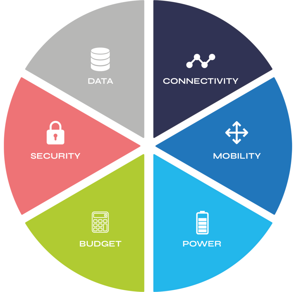
Data: satellite is more expensive than cellular, so it makes sense to optimise your data transmissions – this will also extend the battery life of your device, if it is battery-powered. Reporting on exception, or using a messaging protocol like MQTT, are increasingly common best practices.
Security: when it comes to sending data to the satellite, and from the satellite to the ground station, this is very secure and hard to intercept. Next, you must get your data from the ground station to your application server. Most companies use the internet for data backhaul and protect their asset by VPN, or a dedicated circuit. Our blog post on ‘How to Improve Satellite IoT Network Security‘ is worth a read for more information on this topic.
The security of the physical asset – the transceiver – is also important, and so look for a ruggedised, small form factor device that can be easily concealed, and will stand up to all manner of weather conditions.
Budget: as your asset will likely be moving in and out of cellular coverage, choose a device that seamlessly switches between cellular and satellite, such as the RockFLEET, choosing the lowest cost routing. This, along with data optimisation and the appropriate choice of airtime, will keep your costs down.
Power: asset tracking devices are by design not power hungry. There are battery and solar powered options if there is no mains power available; as an example, a company we work with on endangered species preservation builds a satellite transceiver into animal tracking collars, which then typically last around 3 years on a single charge.
Mobility: in this use case you are expecting the asset to move; that means you either need a device that auto-points itself at a satellite in geostationary orbit, or use a device that connects with satellite constellations in low earth orbit (LEO). The latter is often a better choice for land freight as it is easier for LEO devices to find a signal when passing through wooded or hilly territory.
Connectivity: Make sure you’re using the appropriate airtime for your needs. Satellite connectivity has diversified a great deal, so don’t pay for broadband when you only need event driven messaging like Iridium’s Short Burst Data, or Viasat’s IsatData Pro.
Get in touch
If you’d like expert guidance on your asset tracking needs, please get in touch by completing this form or emailing hello@groundcontrol.com.
With over 20 years’ experience, we are well placed to advise you on the best hardware and airtime to meet your specifications.
2021 – The Year Your iPhone Calls go Extra-terrestrial?
In a recent address to investors, TFI International Securities analyst Ming-Chi Kuo predicted that the next iPhone will utilize satellite communication, enabling calls and messages when users are out of 4G/5G coverage. This promptly resulted in shares in Globalstar (Kuo’s named satellite services provider) closing up at 64% at the end of August (CNBC).
It’s quite extraordinary when you think about it; at Ground Control, we pride ourselves on our ability to retrieve data from anywhere on Earth, no matter how remote, but enabling all iPhone users with the ability to use extra-terrestrial networks to phone home is a dramatic step forwards in the ubiquity of satellite connectivity.
So, are we mere mortals really going to be able to make calls and send messages from literally anywhere on Earth? Devices like the RockSTAR have made this possible for adventurers and explorers, as well as remote field workers, for many years, and their robust battery life will continue to lend themselves to many applications. But for the average person, will anything truly remote exist?
People who romanticize about being ‘off grid’ won’t be; there’ll be no excuse not to keep your family, co-workers and friends regularly informed about your location and wellbeing, and for some people, that’s not as appealing as it might be!
Where does this development lead?
With the speculation that Apple’s latest iPhone model will have satcom connectivity “as standard”, could there be a space race of a new era? Musk’s satellites, Iridium’s low earth orbit satellites and Inmarsat’s geo-stationary network could be utilized in a way previously reserved for the securest and most confidential business, government and military comms.
The GSMA real-time intelligence data estimates there are 5.28 billion people in the world that have a mobile device. For context, this means that 66.92% of the world’s population has a mobile device. That’s a lot. And a large incentive for Android to follow suit.
Currently billed as being available only for emergency comms where 4G/5G coverage can’t quite reach, it’s potentially only a matter of time before we’re all casually phoning home from space.
Get in touch
We’ve implemented satellite IoT infrastructure for decades, and there’s very rarely been an obstruction issue we couldn’t overcome with a bit of knowledge and ingenuity.
We’d be happy to talk to you about your project and offer impartial advice on the best antenna and satellite service for your particular requirements. Call or email us, or complete the form.
Introducing Intelligent Cellular ‘i-Cell’
Ground Control welcomes its newest cellular offering – the i-Cell range.
The Smart Solution
The sun is soon to set on the second- and third-generation (2G and 3G) networks around the world. In response, we’ve developed a smart solution to automatically switch from 2G to LTE spectrum encompassing eUICC technology.
We’ve already developed a number of products in the i-Cell range that have been rolled out in beta to a number of our customers – the response has been phenomenal. With the third product just released, we thought it was high time we started to shout louder about this amazing step in cellular technology.
The i-Cell range of cellular communication products are ideal for utility, IoT, retail, and many other applications – thanks to its compact size and cost effectiveness. These next-generation products support all the new features specified by 3GPP to boost IoT applications, such as power-saving mode (PSM) and extended discontinuous reception (eDRX), which, along with proprietary firmware from Wireless Innovation, allows the modem to wake up periodically to deliver data and then go back to sleep, providing ultra-low power consumption for long-term battery applications.
Products Available
- i-Cell D-Sub 2G/LTE – The i-Cell D-Sub 2G/LTE modem supports worldwide LTE CATM1 and NB-IoT communications, as well as providing legacy 2G quad band support. It features a maximum downlink and uplink data rate of approximately 300Kbps.
- i-Cell OEM Communicator – Connect your information via the cloud from low-rate, ultra-low power to video streams with i-Cell Communicator, the Swiss Army Knife of IoT.
- i-Cell 1140 2G/LTE – The i-Cell 1140 is designed to fit the standard Elster A1140 meter range, and interfaces with the proprietary interface via an RJ12 connector.
- i-Comm Secure – The i-Comm Secure is an encrypted communications device, linking assets via a WiFi or LAN connection, with full remote management and supervision.
Telit
The i-Cell range utilises the Telit ME910 module for its D-Sub product. This features eDRX and PSM support, a highly compact 28 × 28 mm LGA form factor, and maximum downlink and uplink data rates in the range of 300Kbps. The overall range also uses Telit connectivity solutions for SIMs and data plans. Find out more about our work with Telit.
Ground Control will project manage and deliver the complete solution, from the delivery of the hardware and the integration to the customers’ equipment, so they can understand the latency they can work with and the required space segment to meet the required latency.
Want to know more?
Our team of industry experts designed and manufactured the i-Cell range to meet the discerning needs of Utilities and Retail organisations needing a solution to the sunsetting of 2G and 3G networks.
To talk to us about your requirements, please call or email us, or complete the form, and we’ll be happy to help.