Author: Becka Badby
5 Steps To Reducing IoT Connectivity Costs
Connectivity is often identified as a barrier to IoT deployment success. Inmarsat’s 2023 Enterprise Insights ranked access to reliable IoT connectivity as a top challenge with over one third reporting difficulties (34%); and 33% struggling to implement IoT solutions in remote locations.
To harness the full value of IoT enablement, terrestrial, fibre and Long Range Wide Area Networks (LPWAN) are vital. But these networks are limited. Covering approximately 15% of the Earth’s surface, they do not provide the global coverage essential to capture all data points and fail to capture valuable insights from the most remote locations. This is where satellite IoT connectivity can help.
A staggering 91% of businesses surveyed by Inmarsat believe satellite connectivity is key to improving the effectiveness of IoT solutions. But many still consider satellite connectivity expensive. Our response? It’s far more cost-effective than you might think.
How to reduce Satellite IoT connectivity costs
IoT applications consist of multiple, connected devices which collect and analyse data in real-time. Applications dealing with mission critical data often also have devices intended for failover comms in the event that their main form of connectivity fails. To maximise project value, reliable connectivity is essential.
Since connectivity costs are largely based on the volume of data sent, optimising data mobility can significantly reduce overall connectivity costs while maintaining maximum project value. Below are 5 ways businesses can reduce their overall satellite airtime costs:
- Remote terminal management
- Real-time data management
- Determine required data for each application
- Diversify connectivity options
- Edge computing
1. Remote terminal management
To keep operational costs low, designing a network which minimises manual intervention is key. Understandably then, many organisations with devices in remote locations will activate terminals and set these to always-on. Though this is rarely required, physically sending engineers to deactivate/reactivate terminals wouldn’t be worthwhile. But for companies who are able to control terminals remotely, for instance, deactivating devices when applications aren’t live.
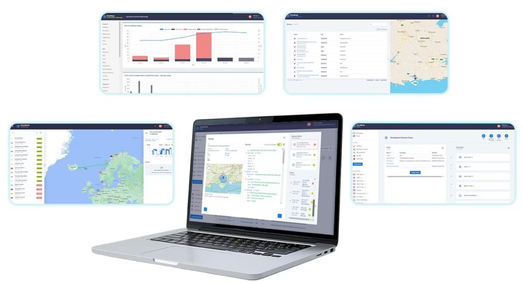
Some companies offer platforms which allow remote activation, suspension, and deactivation. Often these platforms will allow companies to either leverage the API to integrate this service into their own platform or use an online UI to manage their device portfolio, irrespective of device location. In the case of Ground Control, this is managed through our platform Cloudloop. Available via a customer-friendly UI or integrated directly into your business’s ecosystem, Cloudloop puts users in control of their devices and data.
2. Real-time data management
Typically customers benefit from better data rates within service plans as opposed to pay-as-you-go options. So accurately predicting and then choosing the right data plan for each device before you start using it is an easy way to make sure you’re getting the best rate for your airtime. The other benefit is avoiding overage charges: these are applied if companies go over their allocated data allowance and are usually more expensive than the contracted rate. Again, having a well defined view of your data requirements will minimise the amount of times you incur overage costs. If this is a relatively new IoT deployment, companies will likely need to make an educated guess. For those who feel less confident doing so, we recommend you speak to connectivity providers with experience of similar setups so they can advise on likely usage.
Moreover certain airtime and hardware providers offer data management services, allowing organisations to monitor device data usage in real-time. These help businesses avoid bill shock, making appropriate adjustments in real-time and identify if there is a particular device significantly above or below expected use. The latter can be used to help detect early signs of equipment failure or potential security breaches, so companies can take proactive measures.
3. Determine required data for each application
Many businesses apply the same data transmission settings across all devices, all applications. Instead, adjusting settings based on actual application requirements can have a considerable impact on overall connectivity costs. For example, if you choose to send sensor data every 15 minutes but the application only requires data input once an hour; or is only monitoring data to ensure levels remain within specific parameters, you’ll be paying for unnecessary transmissions.
- Frequency of data packets First, consider whether your project or application could tolerate a longer delay between data packets. For some applications it’d likely make little to no difference. Trial adjusting settings so instead of data being sent/received every 15 minutes, this becomes every 30 minutes or even once an hour.
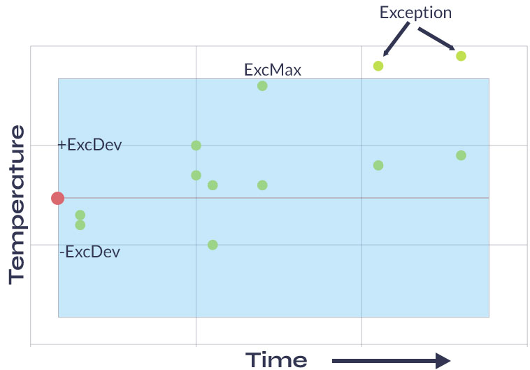
- Reporting on exception Second, does your company require all sensor data? A lot of the data involved in IoT applications verifies that operations are running as expected. Instead, can you configure your system and/or devices to only send data that falls outside set parameters – reporting on exceptions. Not all devices have this functionality but even incorporating a small number capable of supporting exception reporting like the RockREMOTE can lead to a substantial reduction.
4. Diversify connectivity portfolio
The satellite communications industry has seen incredible growth and innovation in the last few years. As such, the options available for both networks and services within those networks have diversified.
For businesses with IoT projects already up and running it’s worth reviewing satellite airtime plans; can cost savings be achieved through simple renegotiation, could assets within your network be switched to alternative more cost-effective services? There are multiple nuances to consider but the savings could be substantial.
One of the most important considerations is regarding message packet size. When utilising Iridium Certus 100, the minimum cost per session is 5KB allowing for a maximum of 20 sessions within (for example) a 100KB monthly bundle. In contrast, with Iridium’s Short Burst Data (SBD) service the minimum is just 10 bytes, meaning users could send 10,000 message packets. Depending on your application’s data requirements this could have a substantial impact. Though SBD is limited to a total of 340 bytes up and 270 bytes down, this is ideal for most asset tracking applications and often one of the most cost-effective satellite services.
For those who need to cover more complex telemetry projects for instance, in the Utilities sector, it’s more likely setups will leverage Viasat’s IoT Pro service (previously known as BGAN M2M). In these situations more practical measures such as ensuring terminals are accurately pointed, reducing the likelihood of message packets being dropped, can help reduce overall costs.
If you do have any specific queries related to airtime, please don’t hesitate to get in touch. We’ve been doing this for over 20 years and though we have significant relationships with both Iridium and Inmarsat we’re not tied to any one provider, just helping you find the best solution for your project and budget.
5. Edge computing
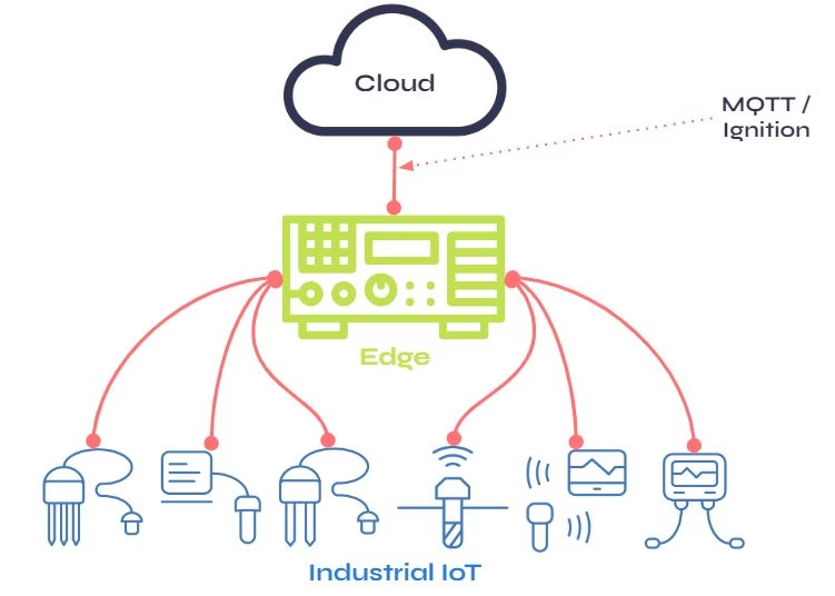
Edge computing is an emerging computing paradigm, which has arguably become a bit of a buzz term. In short, it allows companies to process data where the data is being generated – at the edge. This reduces overall data transmission, for example, to the cloud. Though data processing within the cloud has become popular in recent years, to achieve this, companies must first employ the relatively expensive transport mechanism of getting all data to the cloud. Instead, with edge computing, businesses can be more efficient with the volume of data sent, conducting some processing locally.
Again, not all devices are able to facilitate edge processing and typically companies with more established IoT deployments may have hundreds, if not thousands of units. So though it might not be economical to replace all units, in situations where terminals are reaching end of life or those organising a new IoT deployment, choosing edge-computing-capable devices could be worthwhile. Edge-computing-capable devices can reduce overall connectivity costs and extend the life of other units within the network. So even a relatively small investment could prove beneficial.
As satellite technology advances with the likes of nanosats, it’s likely satellite communications will continue to become more cost-effective and services more diverse. In the meantime there are many tactics companies can employ to optimise data mobility and thus reduce satellite IoT costs.
If you or your team would like any advice on the best network or service fit for an IoT application, or would like to review your satellite IoT airtime costs, simply fill in the form below and one of our team will get in touch.
Ready to unlimit your IoT application?
Having partnered with satellite network providers such as Iridium and Inmarsat for well over a decade, we have access to competitively priced tariffs, and can also be very flexible in terms of bundled data.
So if you are working on an IoT project and would like some no pressure, objective advice, simply fill in the form and one of our expert team will get back to you.
Resilient Communications via Satellite for Autonomous Agricultural Robots
The Agriculture industry is facing a number of significant challenges, not least, providing food security to a growing population. The United Nations Food and Agriculture Organisation has estimated that food production will need to increase by 70% by 2050, to meet the needs of the expected 9 billion population.
Labour remains key to harvest, especially with specialty crops – typically representing 20-50% of the overall crop budget. But factors such as an ageing workforce, increasing competition for labour from other industries and foreign labour costs continue to widen the gap between available and required labour. A challenge further exacerbated by Brexit and more recently, the pandemic.
Moreover, Agriculture is highly water dependent and the impacts of Climate Change are contributing to scarcity and shortages. In short, there are many trials facing the Agriculture sector. All necessitate an increase in Agricultural productivity.
Technology has long provided solutions and there has been an increase in interest and investment in AgriTech solutions. Predicted to reach $46,372 million by 2030, global AgriTech is a well established yet fast developing market.
What is AgriTech?
AgriTech describes the use of technology to produce more with less. This spans tractors to drones, milking machines to vertical farming and automation. These help farmers and agriculturalists increase efficiency from field monitoring, to the food supply chain itself.
AgriTech includes the Internet of Things (IoT) which has and continues to transform almost every sector – Agriculture is no exception. IoT refers to a network of connected devices that collect and share data with other devices and communications networks, allowing for real-time monitoring and control of various systems.
In Agriculture, IoT devices include sensors that measure soil moisture, temperature, and other environmental factors, as well as weather stations, drones, animal tracking collars, and other connected devices that can provide valuable data about crops and livestock. This data can then be used by farmers to make more informed decisions, for example, when to irrigate.
IoT in Agriculture
Ground Control is proud to work with a number of customers driving IoT in Agriculture forward. Just one great example is Synnefa. Synnefa provides IoT devices integrated with farming software to 8,726 farmers across Kenya.
The combination of data from IoT devices in the field, farmer activity and trend analysis, help deliver insight to either enable the farmer to make more informed decisions; or use Synnefa’s smart greenhouses to automatically complete tasks, for example fertilisation, based on sensor data.
The results:
• 50% reduction in water usage
• 41% reduction in fertilizer application rates
• 30% average increase in production when compared to yields before IoT device implementation.

What are Autonomous Agricultural Robots?
Autonomous Agricultural Robots (AAR) are machines that can perform agricultural tasks without human intervention. Equipped with various sensors, cameras and other technologies, they can navigate fields and perform specific tasks, including planting and monitoring and managing livestock.
The sensors, software and connectivity which enable these machines to collect and exchange data, means AARs can be considered a type of IoT. So these machines are able to communicate with other IoT devices, such as irrigation systems, enabling farmers to create more integrated and efficient farm management systems.
Common applications of Agricultural robots
1. Harvesting crops
Through detection and classification of plants and their characteristics, robots can be programmed to harvest crops based on factors that indicate ripeness, for example colour. Those with GPS systems can be used in tandem with pickers working in fields. As these robots benefit from speed and accuracy, they can improve yield size and reduce waste while reducing workforce reliance.
2. Drones
Can be used in multiple ways within Agriculture to automate tasks and improve crop yields. Some examples include:
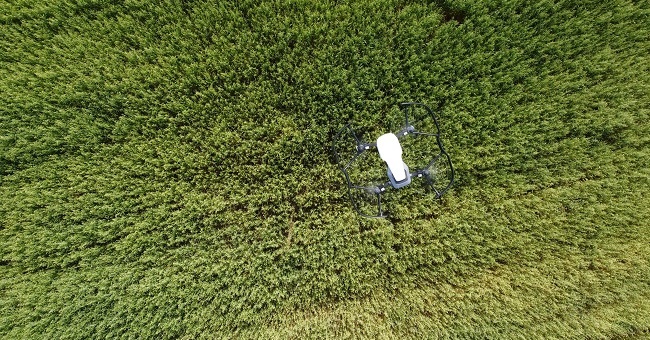
Crop monitoring: equipped with sensors or cameras, drones can be flown over fields to collect data on crop growth, health and water stress. This data can then be used to create detailed maps enabling farmers to identify areas which need attention and adjust irrigation or fertilizer application.
Crop spraying: fitted with spray nozzles, drones can apply pesticides and other chemicals with high accuracy, minimising the amount needed.
Livestock monitoring: utilizes drone cameras to allow real-time information on animal health and behaviour. This can be used to help track grazing patterns or even identify stressed or sick animals.
3. Weed control
Ag operators can use autonomous robots to control weeds in a more precise, efficient and environmentally friendly method when compared to traditional methods. Just three common examples:
Automated mechanical weeding: soil-based weeders can navigate autonomously around fields, detecting plants via infrared sensors or cameras. Once weeds are detected, machines use a rotary cutter to cut these at ground level.
Chemical spraying: uses autonomous robots to apply herbicides to weeds in a targeted manner. The robot can use computer vision to identify weeds and spray only the areas where weeds are present, reducing the amount of chemicals used and minimizing the impact on the environment.
Thermal weeding: similarly to the above, autonomous robots use computer vision to identify weeds and target them with an appropriate amount of heat to kill the weed, negating the use of chemicals.
4. Autonomous tractors
Using a combination of sensors, GPS technology and cameras, these self-driving vehicles can perform tasks such as ploughing, tilling, and spraying crops.
They can also be used to collect data regarding soil health, crop growth and weather conditions while they work, enabling farmers to focus on other tasks, for example ensuring proper drainage.
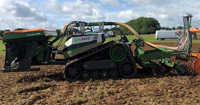
5. Planting crops
Agricultural robots are able to track the position of rows while planting, adjusting their trajectory accordingly, to ensure precise spacing between each seedling. GPS-based equipment also allows farmers to program the AAR with desired planting depth based on field location to give the crops the best chance of survival.
The opportunities associated with the use of autonomous agricultural robots as part of precision agriculture systems are significant – improved efficiency, labour productivity, minimised environmental impact, all while increasing crop yields.
Though AARs are still very much within their evolutionary infancy, autonomous tractors and drones in particular have become increasingly popular tools. A recent report valued the global autonomous farm equipment market at $62.89 billion and went on to predict market value would reach $250.6 million by 2028.
As with any relatively new technology, there are a number of challenges. Not least, connectivity. As Rohan Rainbow of Grain Producers Australia puts it – “more than half the farmers in Australia have no access to cellular phone connectivity… That’s actually quite a challenge if you want to service your machine or just run diagnostics on whether this machine is performing correctly and providing that information back to the operator.”
Beyond data transmission, the main issue associated with poor or no connectivity is when machines in the field detect an obstacle. When this happens, without the connectivity to receive a go/no go command the machine will sit still until either the perceived obstacle moves, or the Ag operator notes the machine isn’t where expected and goes to find and then reset it. To put this into context, even in the UK those utilising autonomous agricultural robots found they were having to go into the field roughly once every 10 hours.
As connectivity specialists it would be remiss to not highlight the role of satellite connectivity in overcoming these challenges. After all, to gain the true value-add from any of these applications, resilient communications are essential and only satellite offers ubiquitous coverage.
Overcoming connectivity challenges with the RockREMOTE Rugged
Designed for permanent outdoor installation in harsh environments, the RockREMOTE Rugged is ideal for fixed or mobile environments anywhere in the world. Featuring a new form factor, waterproof and vibration tested, the RockREMOTE Rugged connects assets and machines with Iridium satellite or LTE networks.
Featuring an omni-directional antenna, the RockREMOTE Rugged is able to securely connect remote IoT assets using IP or message-based protocols. The powerful Linux-based operating system offers containerized hosting for edge-computing applications.
Having spoken with a number of manufacturers, we’re confident the RockREMOTE Rugged is a great solution for any Agricultural manufacturers or OEMs looking for a robust, reliable communications system.
Looking for a communication solution for your AgTech?
We’d love to hear from you. Ground Control has been delivering satellite connectivity solutions for over 20 years. Already proud to work with a number of OEMs and manufacturers, you can find out more about our partner programme following the button below.
To discuss further what satellite connectivity could look like within your machines, and how we might be able to make that process as simple as possible – fill in the form and one of our expert team will be in touch.
How RockSTARs Are Being Used to Keep Remote Personnel Safe
Most of us are familiar with the limitations of terrestrial networks. However, for those working as a field engineer or as part of an expedition team; who have been a competitor in a yacht race or taken part in military training; you’ll also know how important it is to overcome this limitation. Cellular connectivity only covers 15% of the globe and there are many reasons why someone may take the roads less travelled. For the purpose of this blog, the term remote personnel refers to anyone travelling outside cellular coverage regularly, or for an extended period of time – be that for work or leisure.
For both safety and well-being, it’s essential that remote personnel have access to two-way communication that functions both in and out of cellular range. Determining a tracking and communication plan will reduce the chance of accidents and ensure swift response times in the case of an emergency; and by encouraging the use of two-way notifications and alerts, deliver peace of mind. This is where Ground Control’s RockSTAR device can help.
Introducing the RockSTAR
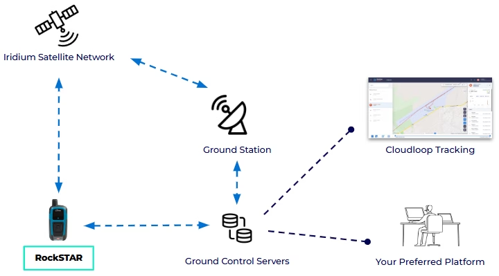
The RockSTAR is a lightweight, rugged, handheld device that can be used to send and receive short messages (like SMS and short emails) and track GPS location, through the Iridium satellite network and back to Earth. Simply, if the unit has a clear view of the sky, it’ll deliver two-way communications and virtually real-time tracking, anywhere and everywhere.
How do RockSTAR devices work?
Each RockSTAR unit houses an Iridium 9602 modem. This modem allows the device to leverage the Iridium Satellite network – using the ‘short burst data’ (SBD) service, to support location and messaging data transmission.
The RockSTAR can be set to ‘wake up’ and transmit your location anywhere between 15 seconds and once a day. It’ll obtain a position using the GPS satellite network, and then transmit that position back to Ground Control HQ using the Iridium satellite network. In 1-2 seconds, the position can then be visualised on our easy-to-use web-based system or automatically set up to relay this information direct to your application.
For example, if you’re a field technician working in a remote area, location data can be sent direct to whichever security tracking application your employer is using. What’s more, RockSTAR units have a great battery life. Even transmitting location data every 15 minutes, a device will last 3 weeks between charges.
In addition to SBD being relatively low cost, there are no annual contracts, delivering flexibility for those who only require a satellite device like the RockSTAR for a specific trip or project. In short, if you or your team don’t need to use a device for a month or more, there won’t be any monthly fee, simply pay ‘per month, per device’.
Additional RockSTAR features
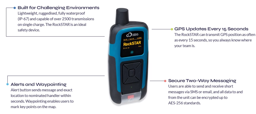
Designed and built in the UK, the RockSTAR satellite device has also evolved throughout the years to better meet customer needs. The form factor has noticeably contracted, with the current device standing at just 144mm; other developments have helped create a feature-packed handheld unit.
RockSTAR units can be used to send and receive short messages, including SMS and short emails to nominated groups. Groups are created and amended in the device’s settings and can include mobile phone numbers, email addresses and servers. Using the device itself, you can send pre-set messages or free text; the RockSTAR can also be paired with a mobile or tablet via bluetooth, enabling truly global two-way communications.
The RockSTAR unit is configured with a number of alert options; for full details please see our article on RockSTAR alerts. All six device buttons can be activated by a user in gloves and the main SOS function is initiated via the button at the bottom of the device. When pressed, the unit immediately transmits your location and pre-set emergency message to those nominated within the device’s first-responder group.
The RockSTAR unit can also be used for waypointing, so key points of interest or concern (in the case of wildland firefighting) can be marked while you’re out in the field, and then viewed on our web-based system.
Common RockSTAR applications
Because the RockSTAR device is ruggedized and waterproof, with a great battery life, the applications are vast. Our RockSTAR customers aren’t just worldwide, they’re travelling by land, air and sea. Operating in some of the most remote and harsh environments on Earth. To demonstrate this range, we’ve collated some of the most common remote personnel use cases supported by our RockSTAR devices today.
MILITARY EXERCISE MONITORING
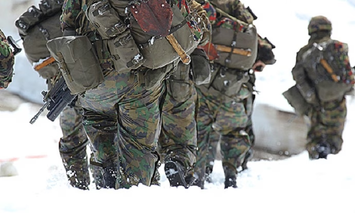
Military training exercises are often held in remote locations, under challenging conditions. This can place significant strain on soldiers, thus tracking services are often employed for peace of mind and if needed, timely, mission-critical response. Ground Control worked in partnership with JCSys to tailor the RockSTAR hardware and firmware to meet the very specific and stringent requirements of the UK’s Ministry of Defence. The result? A compact and durable device able to track soldiers in all weather and military attire, and pair with BLE heart rate monitors. Additionally, developer-friendly APIs meant JCSys were able to securely receive telemetry data and add the required context to support a safe training environment.

TRACKING ANTARCTIC EXPLORERS & RESEARCHERS
RockSTAR devices are ideal for use in extreme environments where wifi or cellular coverage isn’t widely available. As well as being waterproof, units can operate in temperatures between -30 to 60 degrees Celsius and be operated by users in gloves. What’s more, currently Iridium is the only network able to offer truly global coverage – including both poles. We’re proud to have supported both researchers and explorers on multiple Antarctic trips, and our RockSTAR devices have even been used to monitor icebergs across Northern Canada.
SUPPORTING RURAL-BASED POLICE OFFICERS
It is the duty of all law enforcement to “protect life and property through the enforcement of laws and regulations”. This includes serving those in rural-based communities, where cellular coverage may not be available, or intermittent. As all data to and from RockSTAR units can be encrypted up to AES-256 standards, the RockSTAR can be a great, relatively inexpensive solution for two-way communications. We’ve worked with various police units and law enforcement rangers, ensuring personnel maintain connected and tracked at all times.


SAFEGUARDING REMOTE MEDICAL WORKERS
It’s essential that when medical personnel are caring for patients in remote areas, they can be reliably tracked and monitored. To ensure their safety, devices which are lightweight and discreet, with a long battery life are essential. Many security firms have specific applications for remote and lone worker safety, that can be utilised alongside devices such as the RockSTAR to provide a complete, secure solution. We have worked with many companies, creating/enabling specific alert criteria via our RockSTAR devices, even simplifying our menu to ensure it’s as easy as possible for users to access key functions.
What sets the RockSTAR apart from other satellite devices?

Flexible, Secure APIs
We understand many customers will have their own remote worker and/or security applications – so we make getting that data easy. All data to and from the unit can be encrypted up to AES-256 standards, but we’re still able to give customers access to some of the lowest lines of code. This ensures all data transmissions are available in the required format, without compromising security.
Truly Ruggedized
The RockSTAR has been built to withstand the most challenging environments. Tried and tested everyday, everywhere from the Antarctic to the Australian desert, the Pacific Ocean to Rocky Mountains in North America. The device has a number of certifications including FCC and CE MIL-810 F/G for ruggedness, and is waterproof to IP-67.

Customization Opportunities
As manufacturers we have the flexibility to customise the device on larger orders. These ensure the RockSTAR is the best fit for our client’s project. They also enrich the device’s functionality for future users. For example, when working with JCSys, to better safeguard soldiers in the UK, RockSTARs were adapted to disable switch off without a PIN code.
GPS Tracking for Teams
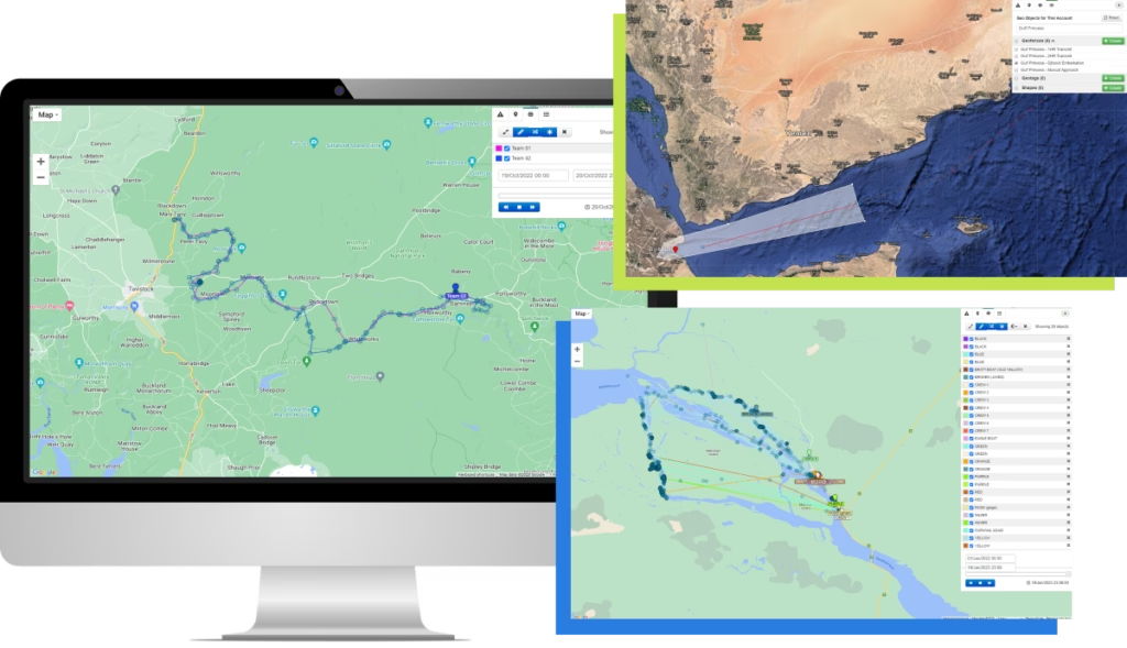
Whether you and your team have one RockSTAR or 1,000, Ground Control’s easy-to-use web platform simplifies device management. From the platform, you can track all of your field workers’ positions simultaneously, both in real-time and across set periods of time.
Users can divide devices into relevant groups and set up multiple platform users with differing permissions. For example, some team members may only need to ‘view’ RockSTAR positions, while others could be allowed to send commands and configure devices in the field.
Within the platform users are also able to:
- Add line rental and credits
- Monitor alerts from all devices
- Set up relevant geofences, ensuring teams receive early warning if a device enters/exits specified areas.
If you’re interested in learning more about the RockSTAR device and how units are supporting remote personnel with ubiquitous connectivity, take a look at our related content: RockSTAR Alerts | Case study – RockSTAR Provides Vital Tracking Telemetry for Soldiers and Ultra Runners | RockSTAR Used in Iridium Certus Demo.
Likewise, if you have any queries you’d like to discuss with our team, simply fill in the contact form below.
Got questions?
Ground Control’s RockSTAR device helps deliver peace of mind to anyone working or travelling within remote locations – unit’s have literally saved lives. From security personnel to armed forces, humanitarian aid workers to aviators, the RockSTAR might be just what you need.
For more information on how we can help solve your remote communication challenges and better safeguard you and your team, fill in the form and we’ll match your enquiry with one of our experts.
How RockBLOCKs Can Transform IoT Projects With Global Connectivity
The Internet of Things (IoT) has been transforming global industry and driving digitalisation for some years now. Simply, IoT describes connecting any device to other connected devices and the internet, or other communications networks. This allows all devices to collect and share data about their environment and how they are used; and it is this data that can deliver true insight.
But this value is wholly reliant on reliable connectivity. After all, for data to enable proactive, smarter decisions, that data first needs to be delivered, for example, from sensor to HQ. In addition, fragmented data and gaps can give a wildly inaccurate picture and cellular connectivity only covers 15% of the globe. This is where Ground Control’s RockBLOCK suite can help.
Introducing the RockBLOCK
RockBLOCKs are transceivers that you can use to send and receive short serial messages, through the Iridium satellite network and back to Earth. They deliver plug-and-play satellite communication, meaning if you have a clear view of the sky, your solution / project stays connected.
How do RockBLOCKs work?
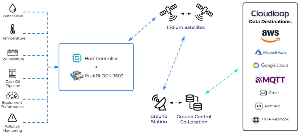
Leveraging the Iridium Satellite network – specifically, ‘short burst data’ (SBD) – RockBLOCKs are connected to a sensor and send this data to 1 of 66 satellites within the Iridium constellation. The satellite then relays this data through the constellation until it’s within transmission distance of Iridium’s ground stations (this takes fractions of a second!). Finally this data can be viewed either in our web portal, or set up to automatically relay this information to email, several email addresses or direct to a web service.
Although SBD only equates to message sizes around 340 bytes up and 270 bytes down, it’s ideal for many IoT applications, including weather balloons, data buoys, UAVs and more. It’s also relatively low cost, and can be purchased on a pay-as-you-go basis, or contracted, which delivers flexibility for developers and educators while testing.
RockBLOCK 9602
RockBLOCK is essentially a development board for the Iridium satellite modem. In the case of the 9602, it hosts the 9602 modem, provides it with an antenna, its power supply requirements and exposes the modem’s serial interface via a breakout connector.
Often used by hobbyists and scientists, it can support many applications, from meteorological sensing, through to preventing fires in remote locations. All you need to get up and running is 5 volts DC, a controller that speaks serial and a clear view of the sky.
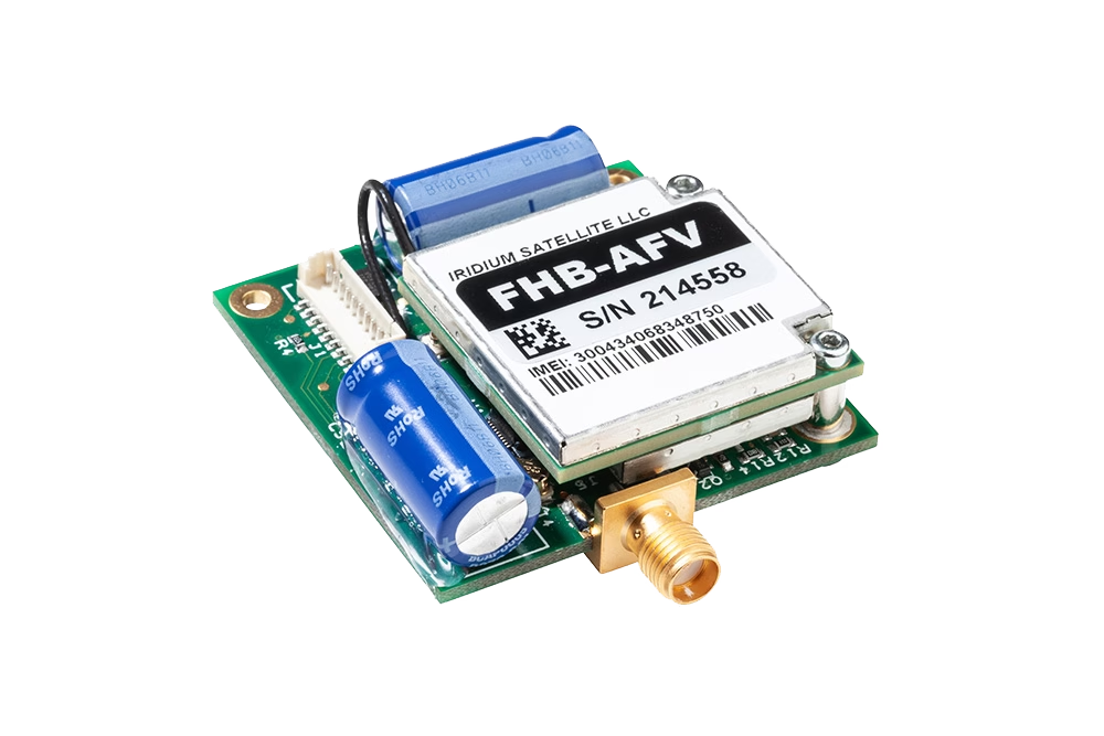
RockBLOCK 9603
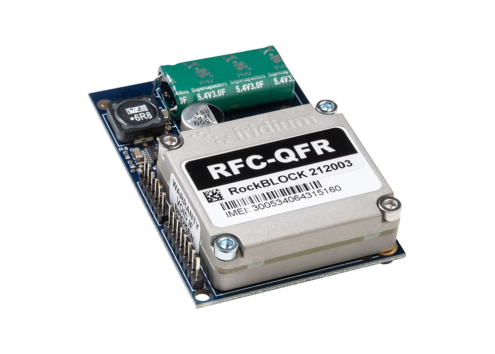
RockBLOCK 9603 is almost half the size of its predecessor and was designed especially for product developers and system integrators used to using smaller equipment for small enclosures.
It hosts a 9603 Iridium satellite modem, has a small form factor Molex connector to link the serial, power, and signalling lines to your controller. This may be slightly harder for developers than the 0.1″ dot pitch header used on the standard RockBLOCK, but we do also have USB serial cables which include the mating molex connector on the other side.
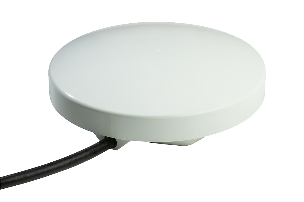
RockBLOCK Plus
RockBLOCK Plus is a waterproof and ruggedized version of the RockBLOCK 9602, with 9-30v power input and RS-232 data link.
It’s designed to transmit sensor data from IoT applications, and is being used in forestry, preventing illegal deforestation and creating alerts for extreme temperature changes; in environmental applications, monitoring earth movement and water levels to provide early warning of landslides and flood risks. It’s also deployed as part of Thailand’s tsunami detection system, with the potential to save many, many lives.
Antenna options – Patch vs SMA
Our RockBLOCK devices include a patch antenna which is suitable for applications where the RockBLOCK can ‘see’ the sky; for example, under plastic but close to the top of the enclosure. However, for applications where the RockBLOCK needs to be situated deep within an enclosure or have a metal barrier between it and the sky, both the 9602 and 9603 have an SMA connector allows the attachment of an external antenna.
Common RockBLOCK projects
Because the RockBLOCK is a small, low cost, low power transceiver, the applications are vast. We work with many partners to bring truly innovative, end-to-end solutions to life. We often partner with those responsible for building the sensors the RockBLOCKs then connect to. To give you an idea and possibly inspire your next project, we’ve collated below some of the most common use cases supported by our RockBLOCK products today.
Tsunami early warning system
When it comes to early warning systems and critical communications networks, organisations need to utilise satellite connectivity, both for the coverage requirements and network reliability. Currently the RockBLOCK Plus is installed across Thailand, empowering their Tsunami early warning system, with ubiquitous, reliable connectivity. The system continually monitors for Tsunami warning indicators, and upon detection – as the RockBLOCK supports two-way communication – it triggers an audible alarm.
Automated landslide monitoring
To reduce the impact of hazardous landslides, enabling proactive, preventative measures to be taken, near real-time monitoring is essential. The RockBLOCK assists regular monitoring of landslide activity with always on connectivity, sending data of high spatiotemporal resolution and centimetre-level accuracy for long-term deployments. Measuring in this way aids in early warning information and limits the use of invasive and expensive drilling, the more traditional landslide monitoring technique.
Environmental monitoring and reporting
Blocked, overflowing systems can cause flooding, erosion, turbidity, storm and sanitary sewer system overflow, and infrastructure damage. Combining data sent via RockBLOCKs within Powered Telemetry Modules (PTM), companies are able to monitor and forecast these events. Utilising a mixture of time lapse cameras, water level gauges, rain gauges, and weather gauges, companies are able to predict where issues may occur and which areas are most at risk, and implement proactive, preventative measures.
Drifting data buoys
Generally, the main purpose of drifting buoys is to measure ocean currents and sea temperatures, the data of which is then transmitted back to research labs on the mainland for analysis. We work with MakerBuoy, who create drifter buoys for individuals and hobbyists to throw into the ocean and retrieve oceanic data; for example, air and water temperature, wind speeds etc. The data retrieved provides vital intelligence for weather and climate models and ultimately aids better understanding of ocean behaviour and intensity forecasting. As the RockBLOCK benefits from pole-to-pole coverage via the Iridium satellite network, buoys carrying a RockBLOCK can transmit this data back to hobbyists, researchers and meteorological organisations for analysis, from anywhere on earth.
Drone connectivity
The applications for drone usage continue to grow: medicine delivery, crop spraying, seed drops, surveillance, meteorology, goods transportation – the list goes on. As many of these tasks take drones into areas with limited or no cellular coverage, satellite connectivity is essential to ensure that, when the drone is Beyond Visual Line of Sight (BVLOS), the drone can still receive commands from the operator.
Ground Control supports UAV and Drone operators with critical Beyond Visual Line of Sight (BVLOS) communications to allow constant connectivity with minimal latency to airborne drones. We use Iridium Short Burst Data (SBD) to allow small strings of data to be sent from a base of operations to the field, providing flight programs, course alterations and other instructions in real time.
Most recently, we’re proud to have had our RockBLOCKs play an important role in the delivery of critical medical care via drone through our partnership with Skylift.
Preventing illegal deforestation
Illegal extraction activities are a significant threat to rainforests and natural resources more generally. With the RockBLOCK, monitoring systems within a rainforest can act as watchdogs. Once certain markers are detected, an alert can be sent and the data analysed by NGOs and governments. If they feel there is an imminent threat, the appropriate authorities can then be notified.
Wildlife tracking
Africa is home to some of the world’s best-known and most iconic wildlife. However, the African Wildlife Foundation (AWF) reports that due to illegal poaching, 43% of the lion population has been lost in the last 20 years.
One of our partners is responsible for creating tracking collars for lions, most notably, in Namibia. Each collar houses a RockBLOCK device, ensuring rangers are able to reliably and effectively track pride movements and ultimately, more effectively protect them.
Off-grid fire prevention system
Regular home fire safety equipment (alarms and extinguishers) rely on a fire to have already entered the premises or someone to be home to raise the alarm. Off-grid fire prevention systems can protect properties and communities, using the data collated to predict and detect wildfires. RockBLOCKs can ensure data is sent from sensors in near real-time and as the RockBLOCK supports two-way communications, once certain thresholds are met, for example significant increase in temperature, a command can be sent back to the system to trigger high-pressure sprinkler systems.
Interest piqued?
Our RockBLOCK product suite is endlessly being used to create really clever, inspiring projects we’d not even thought of and a huge part of this is due to our partners.
If you are interested in learning more about any of the RockBLOCK suite, or partnering with Ground Control on an end-to-end solution, simply fill in the contact form below.
“0 to 1 in Sixty Seconds” – Data’s Journey in Shaping Digital Transformation in Utilities
First coined around 2011, digital transformation according to Salesforce is the – “process of using digital technologies to create new — or modify existing — business processes, culture, and customer experiences to meet changing business and market requirements.”
With global spending on digital transformation set to double to $2.8 trillion by 2025, digital evolution and smart technology continue to gain significant traction, especially within Utilities and Renewables. Described as at the center of a massive global shift, the Utilities sector is under considerable pressure. With global energy demand expected to increase by 37% by 2040 and surges in demand for renewable energy resources and sustainability; more Utility companies are turning to digital strategies to become more agile, competitive and resilient.
The challenges and opportunities of digital transformation in Utilities are very well documented. However, having served Utilities for over 20 years, we know the role data has played in shaping this transformation. We’ve created a paper covering how far Utilities companies have come in terms of collecting and analysing data to streamline their operations, and how data is likely to shape digitalisation in the future.
Electrical grids and gas distribution systems are critical infrastructure. Outages and supply interruptions result in huge financial burden and penalties for the supplier, and severe (often prolonged) disruption for consumers. With increasing pressure for renewable energy and from customers seeking to generate their own power, digital transformation could be the catalyst Utilities need to boost consumer interest.
The UK Department of Energy and Climate Change has invested heavily into its smart grid vision and route map – building a smart grid across the UK. Smart meters and sensors along grid lines transmit usage data to providers, enabling them to match supply with demand. Likewise, smart appliances can alter the times of electricity usage, avoiding peak times when pressure on the grid is high, resulting in lower costs and reduced risk of outages.
It is these detailed insights into customer habits that does and will allow Utilities to achieve maximum efficiency and customer satisfaction. And at a time of expensive grid updates, usage trends could prove invaluable to planning and prioritising engineering work, and the most efficient means of distributing utility supply.
Big data, machine-to-machine technology, and dependable connectivity provide the means to understand consumer trends and predict future utility usage. Companies failing to incorporate a robust data strategy into their business plan are likely to find themselves at a major competitive disadvantage, if not already, in the very near future.
The future of connectivity
Although not covered in the paper directly, data retrieval is dependent on connectivity. Inmarsat reports that 58% of electrical Utility providers are unable to implement IoT projects due to availability of reliable connectivity in required areas. Data gaps and delays can lead to inaccurate pictures of infrastructure and supply. With Mobile Network Operators (MNOs) sunsetting their 2G and 3G networks, and PTSN set to be switched off in 2025, it is becoming even more difficult for Utility providers to secure reliable, consistent connectivity throughout their supply chain.
Cellular connectivity continues to advance and a recent survey by Deloitte highlighted that 26% of respondents within Utilities had included 5G within their strategy, with a further 36% stating they planned to. However, while cellular connectivity provides a viable alternative, some sites are so remote that there is no cellular coverage. 8% of the UK’s landmass remains uncovered by mobile networks. What’s more, it will be many years before fibre finds its way to these remote locations – if indeed it ever does – and it’s cost-prohibitive for most companies to fund this privately. Satellite is already used by a third of Utility companies and given the challenges ahead, satellite could prove pivotal to creating a more resilient grid.
Data security
Data security continues to be top of mind for Utility providers, with cybersecurity breaches on the rise. IBM reported a 10% increase, from $3.86 million to $4.24 million per incident, in data breach costs between 2020 and 2021. And the energy industry ranked fifth in data breach costs, surpassed only by Healthcare, Financial, Pharmaceutical and technology verticals.
Arguably, security is also becoming more of a focus for consumers. According to our survey of utility users, hackers bringing down internal systems (as was done in the Colonial pipeline attack), was identified as a potential risk to utility supply by 46.9% of recipients. Given that almost half (46.7%) of March’s survey respondents stated there was a slightly higher cybersecurity risk to Utility supply due to the war in Ukraine, and 20.3%, a substantially increased risk, this is clearly a growing concern.
Is satellite connectivity secure?
Satellite communications are as secure as any IP connection. Cybersecurity can be enhanced by securing data paths with encryption, and where appropriate, creating systems completely redundant from public networks and infrastructure. What’s more, any security protocols already in place will operate over a satellite network.
When working with companies within the Utilities and Renewables industry, one of the first questions we’ll ask is which communications they are most concerned about from a security point of view. And often, we’ll advise TSAT. TSAT provides a private satellite network operating a direct communication channel between a process control center and remote locations, specifically designed to meet the demanding requirements of the SCADA and utility industries. TSAT complies with AES-256 encryption and authentication. Furthermore, it’s completely isolated from the Internet or any other network, riding over a dedicated space segment of one or more satellites for redundant fail-over reliability, in multiple topologies.
Cyber security features include: VLAN (Virtual LAN) support, file system encryption, secure Linux login to avoid unauthorised access, and SW/FW upgrade over-satellite authentication.
For more information regarding security and connectivity more generally, take a look at our recent eBook.
Secure data transmission: the key to unlocking Utilities’ operational success?
The key to operational success in Utilities is to collect accurate, real-time data throughout the supply chain. But data collection is increasingly fraught with risk as cyber-criminals target infrastructure. Our eBook explores three main challenges facing Utility providers: security, ageing infrastructure and climate change, and explores the role of connectivity in overcoming these.
Get in touch
We are proud to have provided one of our utility customers 27 years uninterrupted service, making satellite that company’s most reliable system.
To learn more about our solutions and how these can help you consistently provide better for your customers, contact hello@groundcontrol.com.
The “Short” Story of Ground Control
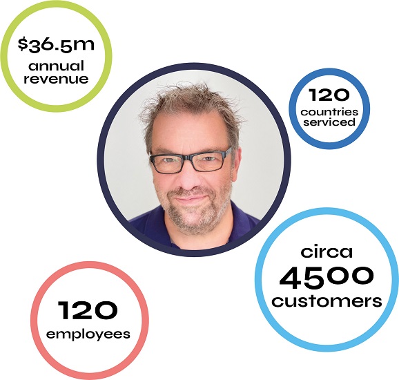
2022 marks the official 20th anniversary of Ground Control. Ground Control as we know it today, is formed from the merger of three companies – US-based Ground Control, and UK-based Wireless Innovation and Rock Seven. The result? A best-in-class IoT, M2M and critical communications service and technology provider, we service 4,500 customers across 120 countries worldwide.
We’re in a somewhat unique position at Ground Control, in that founding members from each business still consult and work within the company today. So to celebrate this impressive milestone, particularly in the fast-paced industry of satellite communications, we have amalgamated the “short” story of Ground Control.
Mark Wright, Founder of Ground Control in North America
Following the sale of his highly successful dial-up internet services business, ‘The Grid’, Mark went out on the open road with a newly purchased RV. In 1999, cellular data service didn’t yet exist and as Mark puts it – “as an internet guy, I wasn’t going to go without, so…”.
After some digging, Mark discovered Direcway satellite service for fixed home installations. It was wonderful new internet technology, but not a technology that could be taken on the road. Undeterred, Mark researched and found a company in Salt Lake City that manufactured RV TV antennas and commissioned them to develop a mobile solution for the Direcway dish in 2001. The result? DataStorm. The first affordable mobile satellite system in North America. The product was a huge success, meeting the needs of RVers and professionals across North America.
However, Mark felt that although the product was a great success, it was really lacking a quality service provider. So he founded Ground Control in 2002 to be that provider.
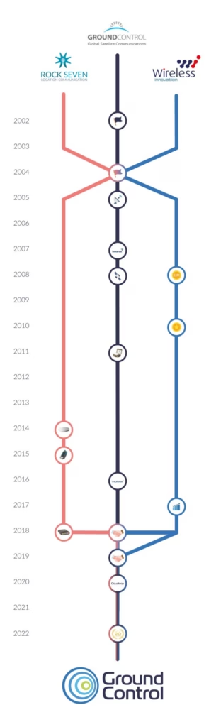
Mark’s background in internet services rapidly propelled Ground Control to become a leader in mobile satellite-driven internet services in North America. As Mark states – “the key to growth was always quality customer service, quality hardware and a bit of good marketing. Word of mouth is what really propelled Ground Control.”
Phil Rouse, Founder of Wireless Innovation in the UK
Around this time, in 2004, there were some exciting developments in the UK. Phil Rouse wanted to transform the business he worked for into one solely focused on satellite, radio and WiFi. Given his proposal was based on a Management Buy Out, he also had to pitch Wireless Innovation to potential employees he wished to move across. Phil states – “I was really humbled by their response. There is always an element of risk and these people had families to support, burgeoning careers. But they trusted me. And they were completely onboard for the vision I had for Wireless Innovation from the very beginning.”
Phil already had great relationships with TSAT, an expert SCADA device manufacturer, and Iridium, a satellite network provider specializing in global, low latency M2M connectivity. These enabled a strong sales proposition, and within just six weeks, Phil’s team had brokered a sale with large Italian utility company Telespatio. Even with the experienced team, given how new the company was, this was no small feat.
Ric Searle, Co-Founder of Rock Seven in the UK
Meanwhile, also in 2004, Ric Searle and Nick Farrell started Rock Seven, developing solutions based on cellular location services which were emerging at the time. Early applications tracked the location of engineers for electricity companies, so they could deploy the nearest, appropriately skilled engineer to attend to faults in the network.
As time progressed, Ric explains – “I stumbled across an opportunity to deliver a tracking system for offshore yacht racing, which led to us finding an Iridium tracking product and developing a race management system and viewer, that became YB Tracking. We eventually decided that we could develop better hardware ourselves… So we did.”
This ultimately led to Rock Seven’s reputation for reliable, accurate global tracking of personnel and/or assets via relatively small devices. More commercial applications, including fisheries, emerged later on. Due to their early experience in offshore yacht racing, maritime is still a large focus for Ground Control today.
Since then, there have been multiple milestones for all three companies. To mention just a few, Jeff Staples (current President of North America) joined Ground Control in 2008 and in the same year, launched Ground Control’s flagship VSAT solution, the Toughsat XP. Through a program of continuous improvement, it remains a best-seller today. In 2008, Wireless Innovation landed their first £1 million deal and in 2010 were awarded the Queen’s Award for Enterprise. Not to be outdone, Rock Seven designed, engineered and manufactured the RockFLEET, an improved RockSTAR device and the RockAIR.
The new era: Private equity
2017 would mark the next significant moment in Ground Control’s journey. The founders of Wireless Innovation wanted to sell, Phil Rouse wanted to continue his journey with Wireless Innovation. So Phil set out to seek further financial investment, leading him to then Lyceum Capital, now Horizon – a UK-based private equity firm.
Horizon tasked Phil with creating a group of companies within the satellite and cellular space, which would enable each to expand their product lines and knowledge base and ultimately, bring new compelling solutions to the market.
Rock Seven, while serving a different customer base, had clear synergies through their use of Iridium’s short burst data (SBD) service, and their design and build capabilities made for a great fit. Similarly, the engineering capabilities of Ground Control, in addition to the US foothold, made the company a valuable addition to the newly formed group. The company benefited from the collective experience of its expert staff, supplier relationships, manufacturing capabilities, and a truly global customer base.
Phil explains – “I’ve always seen the key value-add of Wireless Innovation, now Ground Control, as a company capable and willing to take full ownership of the overall solution. There are a lot of players who offer plug-and-play communication systems, but ultimately Ground Control takes the time to understand how, what and why our customers applications work; the data required, frequency of communication needed and the utter importance of the customers application data. Ground Control uniquely positions itself to fully understand both ends of the data communications equation with our customers. And in my opinion, this understanding leads to better solutions for our customers and has been the differentiator between us and competitors.”
Celebrating 20 years of innovation
Shortly after the merger, Mark Wright retired and Phil Rouse stepped down in 2020, though both remain highly valued mentors for individuals and teams across the business. Alastair MacLeod was then appointed CEO of the Group and has made significant strides to amalgamate, while being careful to not lose sight of the relative, individual strengths of each business. Alastair often describes Ground Control as a large company that feels small. All three companies were founder-led. That entrepreneurial spirit, creativity and additional care taken with customers when they are dealing with a smaller firm, is something all teams work hard to maintain, despite the increasing headcount.
As Alastair puts it – “we start by listening… a lot of the time the real problem that needs solving isn’t necessarily the one they brought to us in the first place and we’re very good at figuring out the underlying issue.”
When talking of the anniversary, Alastair states – “It says a lot about a business, that you stay in business for 20 years; the company is obviously good at what it does. But we’re also fresh; we bring the best of both worlds. Money can’t buy twenty years’ experience, but at the same time we’re fully focused on changing ourselves up, all the time, every year, something new, something better. How can we do a better job next year than we did this year? I think that’s what’s great for customers.”
Looking to the future, Alastair credits Horizon Capital with empowering the company to build new things, grow the team, bring in new skills, as well as retaining and protecting existing experience and expertise. Alastair concludes, – “we’ve been able to leverage our history, our existing resources and investment to build new things, and what comes out of that is something which is genuinely great for the market, and great for customers.”
Can We Help?
With 20 years of experience, we can help you make the best choices for your critical communication infrastructure.
We’re not invested in selling you a specific product or connections, just the best solution for your needs.
Complete the form, email hello@groundcontrol.com, or call us on +44 (0) 1452 751940 (UK, serving Europe, Asia, Africa and Oceania) or 800 773 7168 (North and South America).
Ground Control Recognized as Top 10 Oil & Gas Solution Provider
We’re delighted to announce that Ground Control has been recognised as one of the Top 10 Oil & Gas Solution Providers in 2022.
We have always taken pride in being a partner that truly understands both ends of data communications. Taking ownership of the overall solution and working with our customers to identify not just required volume and frequency of data transmission, but what device compatibility is required and how the data is to be used; to achieve operational goals. We have been creating and delivering advanced connectivity solutions to the Oil & Gas industry for over 20 years.
Solutions for the Oil & Gas sector
We deliver remote connectivity solutions to power Oil & Gas IIoT applications and support global, off-grid operations. Simply put, our solutions help to deliver more reliable data, better safety, cost management and enhanced security.
Popular use cases include remote monitoring and control, pipeline management, asset tracking and lone worker enablement and safety; and facilitating each, is robust, advanced connectivity.
The real value of connectivity
From asset management through to remote performance monitoring and maintenance, the IIoT ecosystem is delivering efficiencies and productivity to meet the demands of an ever-evolving energy landscape.
McKinsey & Company project that advanced connectivity to optimise drilling and production throughput and improve maintenance and field operations, could add $250 billion to the industry’s upstream operations by 2030.
This focus on connectivity, as opposed to IIoT more generally, is key. Despite the myriad of measurable benefits IIoT offers, everything will fall at the first hurdle if connectivity isn’t addressed as a priority. Data enables smarter and faster decisions, but data gaps and interruptions can lead to poor, costly business decisions. To truly harness the value of digitalisation in the field, operators must maintain near real-time, reliable data delivery from all assets within the Oil & Gas supply chain, at all times.
Given the often hostile and remote nature of the environments in which Oil & Gas plants are situated, terrestrial connectivity is not always available, nor reliable. This is where Ground Control really adds value. Using cellular and satellite networks, we specialise in connecting hard-to-reach people, machines and things.
Introducing Iridium Certus® 100
Ideal for IoT and M2M applications, the Iridium Certus® 100 service is facilitated by Iridium’s constellation of 66 LEO satellites. Providing pole-to-pole coverage, with the benefit of lower latency.
Offering IP data speeds of up to 88 Kbps, antennas can be small and lightweight, and do not have to be pointed to pick up Iridium satellites. This enables faultless connectivity to be achieved – even in mountainous or wooded areas.
The Certus-Enabled RockREMOTE
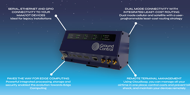
Designed for Industrial IoT, the RockREMOTE leverages the Iridium Certus network and LTE cellular connectivity, end-to-end networking and the powerful Cloudloop platform, to solve remote M2M / IoT connectivity challenges for Oil & Gas. It can be tailored to address a variety of fixed and mobile communications challenges within the Oil & Gas sector.
With serial, Ethernet, and GPIO connectivity to any IoT / M2M devices, it’s ideal for legacy installations; but equally has powerful integrated processing, storage and security features that pave the way for edge computing.
RockREMOTE is a particularly interesting solution for Oil & Gas as its exception reporting capabilities open up a whole new world for optimisation, while significantly reducing costs. By setting parameters to send data only if values change, clients are in a much stronger position to manage their data footprint and thus connectivity costs.
The RockREMOTE is a great solution for:
- Monitoring the performance of pressure pumps in the hydraulic fracturing process
- Capturing the data from flowback well tests
- Capturing production data
Also popular with the Oil & Gas sector
RockSTAR
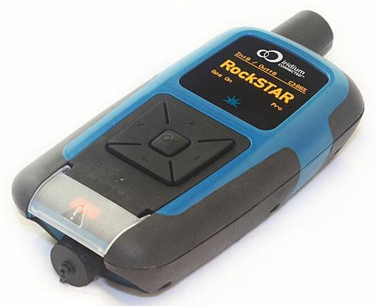
Promoting better lone worker safety, the RockSTAR is a Two-Way Messenger global communication device and tracking system. Working far beyond the reach of Wi-Fi and GSM networks, companies can deliver peace of mind, with location updates, up to every 15 seconds.
RockFLEET
With the RockFLEET organisations know where their vehicles are, at all times and can visualise asset location on an easy-to-use web-based viewer. Additionally devices can be used to measure payload, optimise delivery routes and even capture early warnings of required maintenance.
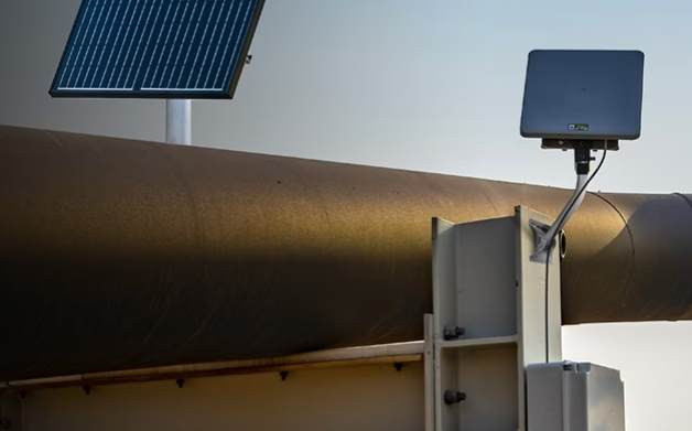
Hughes 9502
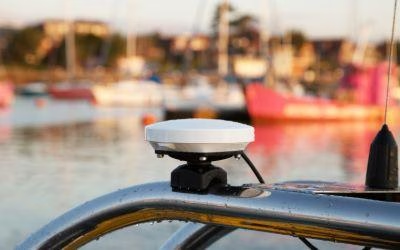
BGAN M2M-capable terminals like the Hughes 9502, are low cost – typically with billable unit costs of 1 to 2 cents per kilobyte, and low power (.01 to 4 watts). Offered in one-piece or two-piece form factors, there is also a variant compliant for operation in Hazardous environments.
Discover the value add of better connectivity
Going digital in the Oil & Gas sector is getting easier. But many companies still fall at the first hurdle – connectivity. We have supported our Oil & Gas customers’ digital projects, IIoT applications and connectivity requirements for 20 years. So, truly – we’ve got you covered.
Interested to see what value better connectivity could deliver for your operations? Contact us today to book a no obligation discovery call.
How Satellite Technology Can Help First Responders With Disaster Relief
Over the last 20 years, there has been a staggering rise in the number of extreme weather events. According to a recent report by the United Nations, between 2000 and 2019, there have been 7,348 major natural disasters worldwide. Tragically, these have led to the deaths of 1.23 million people and resulted in an astounding $2.97 trillion in global economic losses.
With natural disasters becoming more frequent and hurricane season already in progress, it’s vital First Responders look at how they can utilize technology to best aid emergency response efforts. Boasting ubiquitous coverage, satellite technology has been used to support disaster relief efforts since the 1970s.
How First Responders can leverage satellite technology
Satellite imaging and analysis has and continues to develop, delivering crucial, accurate and real-time information to teams on the ground. As an example, California National Guard have been using satellite technology since 2018, to help them fight wildfires.
Satellites equipped with sensors are able to pick up hot spots via infrared radiation detection, effectively enabling them to see heat. This helps the state’s National Guard to detect and map fires, as well as assess the damage they cause. When a blaze is detected, a heads up is sent to one of two California Department of Forestry and Fire Protection-U.S. Forest Service regional operations centers in the state. From there, analysts use the information provided to “very rapidly determine whether or not the fires are campfires or car fires or a fire that could indeed become a very dangerous wildfire” – explains California Adjutant General Maj. Gen. David Baldwin.
However, aerial imaging is not the only way satellite technology can enable a more effective, safer, emergency response. Although terrestrial networks are built to be resilient, outages due to hurricanes, earthquakes, floods and other severe weather is common. With many natural disasters rendering terrestrial infrastructure inoperable, increasingly, redundant communications are becoming an integral part of disaster relief and management.
First Responder communications
For First Responders, the importance of communication can never be underestimated. Ultimately, response disciplines must connect and work together, to ensure the best outcomes during disaster recovery and maintaining public safety more generally.
However, it was reported by the government that first responders in the US rely on more than 10,000 separate, incompatible, and often proprietary radio networks to communicate with each other during emergencies. Given the significant consequences of not being able to properly disseminate information during an emergency, this is concerning.
Critical SATCOM for First Responders
Today, satellite communications (satcom) play an essential role in the global telecommunications system. Approximately 2,000 artificial satellites orbiting Earth relay signals carrying voice, video and data to and from, one or many locations worldwide. While many may be familiar with the benefits of push-to-talk devices and satellite phones, VSAT and Go-anywhere Pro (previously known as BGAN) terminals can also be particularly effective during disaster management.
Following the mass destruction of hurricanes Irma and Maria in 2017, 900 VSAT terminals were deployed at sites around the affected region and critical locations including San Juan Airport. VSAT terminals can enable:
- Data and broadband connectivity
- Voice communications
- High throughput data
- Drone video backhaul
- Red Phone Emergency Responder Voice Network access
As such, they can prove invaluable during disaster relief. VSAT and Go-anywhere Pro terminals not only deliver rapidly deployable connectivity, enabling effective response coordination, they also deliver instant infrastructure. First Responders and recovery teams can communicate with each other and relevant control center(s), analyze the situation and make adjustments.
Connectivity also empowers teams to better support continuity throughout the recovery process. For example, enabling point of sale (POS) credit and debit card authorizations and inventory management, meaning individuals can purchase recovery essentials including food and fuel.
With over 20 years experience enabling critical safety across the globe, Ground Control has been a trusted name in Emergency Responder satcom since 2002.
VSAT and Go-anywhere Pro solutions for Emergency Responders
Toughsat Flyaway Mobile Hotspot
The Toughsat Flyaway is often used by emergency services that need a quick and portable VSAT antenna for both high-speed internet and VoIP phone services for on-site personnel.
The Toughsat Flyaway satellite system delivers Ground Control’s powerful Toughsat XP satellite solution, in an easily transportable set-up. The multi-functional stabilization brackets work for both ground mounting and roof-rack “fly-and-drive” mounting – even on rental vehicles. With an auto-pointing antenna, robust, high-speed internet and redundant communications can be quickly deployed at any location.
We’re proud to say our Toughsat solutions are trusted by hundreds of Urban Search and Rescue agencies, Federal Police, State, County and City Law Enforcement and Fire Departments throughout the United States today.
MCD-4800 “The Football”
Similarly, the MCD-4800 “Mobile Communications Device”, also known as “The Football”, is also capable of providing redundant communications and high-speed internet, anywhere in the world. The auto-pointing Go-anywhere Pro satellite terminal requires no user training to operate and can be used in extreme weather conditions.
Users simply place the weatherproof case on the ground or any surface with a clear view of the sky, turn it on and close the lid. Within a minute the MCD-4800 becomes a powerful WiFi hotspot accessible by any wireless device within a 100 meter range for up to 5 hours on internal battery power.
This auto-pointing solution uses the high performance Hughes 9450TW in-motion Go-anywhere Pro terminal integrated with our proprietary mobile electronics for a ruggedized, self-contained, user-friendly, global communications link.
Ground Control’s emergency communications satellite equipment meets or complies with all SAFECOM requirements, for emergency interoperable communication equipment.
Ultimately, satellite technology helps promote First Responder safety and efficiency, during disaster recovery. The technology has already been used worldwide to monitor events, improve responses and drive resilience post-disaster, providing infrastructure support.
If you’d like to get in touch to discuss potential satellite solutions for your organization or agency, simply email hello@groundcontrol.com.
Get in touch
With over 20 years experience facilitating emergency preparedness and response across the globe, we understand that in a crisis, every second counts. We’re constantly evolving and adapting our Public Safety offer and systems to best support teams on the ground. Which is just part of the reason Ground Control has been a trusted name in Emergency Responder satcom since 2002.
Whatever your communication or connectivity needs, we can help.
Empowering Utility Providers to Better Align With Consumer Priorities
The Utilities sector is in the midst of rapid change. Humans are consuming more energy than ever before, so much so, that the International Energy Agency expects global energy demand to increase by 37% by 2040. Utilities companies are increasing production and distribution capacity to fulfil consumer supply, while navigating a surge in demand for advanced technology, electric mobility and smart cities.
Concurrently, Utility providers are facing a number of challenges, including: ageing infrastructure, climate change and cybersecurity. All of which threaten supply and providers’ ability to cope with increased demand.
To better enable energy providers to respond to this changing, increasing demand, Ground Control surveyed 1,250 Utilities customers based in the UK and the US. We asked consumers direct questions about what they view as some of the largest risks to their energy supply and what would prompt them to change suppliers. Moreover, respondents were surveyed in groups, with some participating in early February, and others in early March. The impact of Russia’s invasion of Ukraine upon consumer outlook is significant, and something Utilities companies really should be aware of. We hope this insight will empower Utility providers to make decisions better aligned with consumer priorities and concerns.
The consumer view of the current Utilities landscape
In comparison to 10 years ago, do consumers feel there has been more service interruptions today?
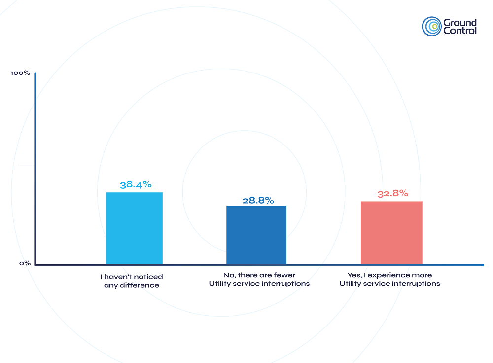
Overall, survey results show that around a third of recipients (32.8%), feel they experience more service interruptions (outages) now, than they did 10 years ago. 28.8% reported fewer Utility service interruptions, and the majority (38.4%), responded to say they hadn’t noticed a difference. Interestingly, UK survey participants were more likely than their US counterparts to respond saying they felt the number of Utility service interruptions had increased, at 35.5% vs 30.2%.
When you consider the number of US power outages in comparison to those in Western Europe, the above is quite surprising. The US government has reported that the average American can expect to lose power for an average of five and a half hours in 2022 and in Western Europe this figure is just once per year, for a lower average of 58 minutes.
There was very little difference when comparing groups who were surveyed in February, to those surveyed in March. With just a slight increase from 32.8% to 34.3% of respondents reporting they felt there has been an increase in the number of Utility interruptions.
What do consumers view as a threat to their Utilities supply?
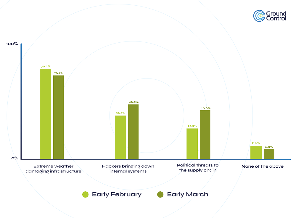
As illustrated above, the majority of consumers (79.2%) surveyed in early February indicated that extreme weather damaging infrastructure was a threat to supply. And a very similar figure of 76.16%, was reported by those surveyed in March. Comparatively, hackers bringing down internal systems (as was done in the Colonial pipeline attack), was selected by 36.3% of those in February, and 46.9% in March. Given that almost half (46.7%) of March’s survey respondents stated they believed there was a slightly higher cybersecurity risk to Utility supply due to the war in Ukraine, and 20.3%, a substantially increased risk, this 10% increase is significant.
Similarly, the number of respondents indicating that they viewed political threats as a risk to the Utility supply chain almost doubled when comparing the February and March survey groups (23.9% vs 40.6%). Again, this is particularly noteworthy as 44.1% of respondents surveyed in March, stated they felt the political risk to Utility supply had slightly increased as a result of the war in Ukraine, and nearly one third (31.3%), that this risk had increased substantially.
Do consumers feel Utility providers are well prepared to manage current risks?
<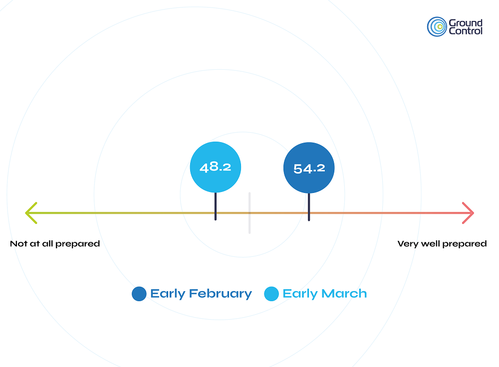
Consumers were asked to indicate on a scale from 0 – 100, how prepared they felt their Utility suppliers were able to manage previously mentioned risks. As can be seen in the above graph, those surveyed in early February responded with an average of 54.21. In contrast, consumers who were surveyed in early March, reported an average of 48.21.
This reduction in confidence is arguably due to consumers becoming more aware of the risks to supply, as a result of the war. Which is certainly understandable, given Europe’s dependence on Russian supplies of natural gas and ongoing sanctions of Russian oil.
What would prompt customers to change Utility suppliers?
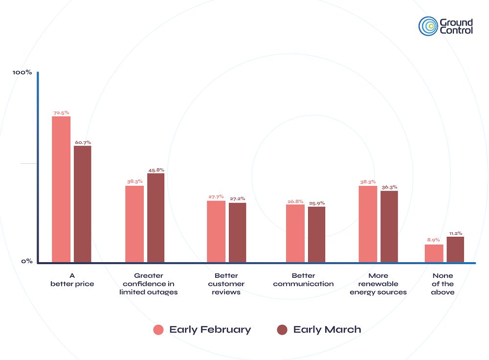
As you might expect, nearly three quarters (72.5%) of survey recipients stated a better price would prompt them to change Utility supplier. However, in March’s survey group responses, this decreased to 60.7%, and greater confidence to limit outages rose from 38.3% to 45.8% comparatively. Which suggests that following the events of the war, customers have become marginally less price sensitive and place a higher priority on steady Utility supply.
Consumers reporting more renewable energy sources, a potential reason to change Utility suppliers, stayed relatively stable across both survey groups at 38.3% and 36.3%. Likewise, 27.8% and 27.2% of each group respectively, stated better customer reviews may prompt them to change energy providers.
Finally, just over a quarter of recipients for both the February (26.7%) and March (25.9%) groups reported better communication as a potential prompt to switch providers. The fact that this figure has remained steady implies that simply improving communications with customers may not be enough to restore the pre-war confidence consumers held with regards to Utility companies ability to manage risks to supply.
In summary, the survey highlights that consumers are relatively clued up on the challenges facing the Utilities industry and that the war has impacted concerns regarding Utility supply.
So, what can Utility providers do?
All Utility suppliers and energy network operators must strive to develop intelligent solutions and energy efficient operations, while ensuring secure infrastructure for the environment today and in the future. Ultimately, the key to success in Utilities is to collect accurate, real-time data from infrastructure and assets, at every point in the supply chain – from networks, plants, to treatment environments and customers. Many companies are already ramping up their development of IoT solutions in order to help them cope with the strain on energy demand. However there are connectivity linkages to each of the previously mentioned challenges of: ageing infrastructure, cybersecurity and climate change.
Why is connectivity so important in the Utilities sector?
Energy providers need to be able to determine the most efficient way to distribute Utility supply while also minimising waste, and distribution is what makes SCADA special. The orchestration of power, water and gas loads, all being reliably routed, monitored and controlled to deliver these resources. This is the centre of the critical infrastructure for every Utility company; and for this to take place, frequent, accurate, reliable data from all sites is required.
TSAT – Ubiquitous connectivity for energy providers
The TSAT satellite system is specifically designed to meet the demanding requirements of the SCADA and Utility industries. TSAT provides a private satellite network operating a direct communication channel between a process control centre and remote locations.
TSAT’s unique private satellite network solution features an industry leading mini VSAT hub that is specifically engineered to support mission critical applications (SCADA / Telemetry) in the energy and utility markets. The ruggedized and utility toughened-hardware is designed to provide years of reliable operation in remote locations and harsh environments.
Get in touch
Our expert team has delivered reliable, secure data transmission solutions to the Utilities sector for 20 years.
We’d be happy to talk to you about your project and offer impartial advice on the best antenna and satellite service for your particular requirements. Call or email us, or complete the form.
Selecting Remote Locations for the Renewables Industry
Renewable energy sources tend to be in remote or hostile locations. Any land-based installation has to deal with the planning process and meet the inevitable objections from local residents and countryside campaigners. This is one of the reasons why land-based wind farms tend to be situated in isolated spots, on hilltops and moors away from settlements and livestock.
Secondly, remote locations are simply better natural environments to generate renewable energy. Wind farms are sited offshore or on remote hilltops because that’s where they’re most efficient – where the wind is strongest. Similarly, solar energy is more accessible in higher, more remote locations where people choose not to settle and tidal power has to be harvested out at sea.
“Customers rarely know exactly what they’re being billed for or what to expect and this makes it impossible to set – and keep to – precise budgets.”
Finding a suitable location
One of the biggest challenges in the renewable energy industry is finding a suitable location. To justify the investment involved in building and installing a wind turbine array, a prospective site has to meet stringent requirements with regard to wind speed and frequency. Too little wind and the array won’t deliver the required amount of power; too much wind and the array is vulnerable to damage.
Similar feasibility calculations apply to solar and tidal installations, all of which require careful and prolonged monitoring to ensure the energy yield from a particular site justifies the investment.
The need for monitoring doesn’t end once the installation has been built. In order to ensure that a solar or wind array is operating at maximum efficiency, a range of key components need to be measured day and night. That data has to be transported securely and in real-time to a control office where metrics such as wind speed, solar radiation power, and individual component performance can be assessed.
For most cellular tracking solutions, this causes significant problems. Moving from one territory to another requires moving from one cellular carrier to another and most cellular tracking services simply don’t have the coverage required to deliver uninterrupted contact or offer a choice of roaming partners. Customers are tied to a single partner in each territory, regardless of the cost or quality of the service. More importantly, this means that if the main signal is lost there’s no fall-back partner and coverage fails.

Moreover, there are significant billing and administrative shortcomings with traditional cellular solutions. Most carriers have different models for billing (fixed price, minimum quantity, per kilobyte of data etc) and this tends to be reflected in the complicated billing structure of most cellular services. Customers rarely know exactly what they’re being billed for or what to expect and this makes it impossible to set – and keep to – precise budgets.
A Track Record of Success in Renewables
Ground Control provides a simple, cost-effective solution to the problem of retrieving assessment and monitoring data. Unlike other M2M solutions, Ground Control provides the flexibility for engineers to design the service that suits them best. This might mean regular ‘heartbeat’ signals or time stamps to confirm the condition of specific instruments. It might mean a series of alarms or triggers configured to meet specific thresholds. Or it might mean a complex combination of variables. Whatever the precise solution required, Ground Control’s services can be configured to deliver exactly the data that’s needed in the most cost-effective way.
Ground Control provides the most comprehensive coverage available from any M2M cellular service. With multiple partners in more than 160 countries, Ground Control’s service gives customers an unrivalled choice of carrier partners and the security of knowing that if their chosen service fails, a fall-back can be configured with an alternative carrier. This failsafe service can be a crucial factor in important infrastructure projects.
In safe hands
If you’re seeking a solution to a critical communications challenge, we can help.
Please call or email us, or complete the form and we’ll be in touch. We have offices in the USA and UK, and over 20 years’ experience in satcomms and IoT, plus access to the best airtime, devices and services available.