Topic: Viasat
From LEO to GEO: Exploring the Different Types of Satellite IoT
The Internet of Things (IoT) has already transformed industry with access to unprecedented levels of connectivity, data collection, and analysis. By enabling devices to connect and communicate with each other, IoT has facilitated smarter, faster business decisions across almost every sector. A reported 77% of surveyed companies had deployed at least one IoT project in 2021, and the remaining 23% were said to either be trialling a project or planned to within the next two years.
The benefits of IoT projects can be grouped into three categories: Operational Efficiency (improving business processes), Customer Experience (enhancing customer relationships), and Growth Opportunities (new revenue streams). Consulting firm McKinsey estimated IoT could enable $5.5 to $12.6 trillion of value globally by 2030. But 75% of businesses reported struggling with connectivity issues when trialling IoT projects, and 91% believe that satellite connectivity is key to improving the effectiveness of IoT solutions.
What is satellite IoT?
IoT describes a system of interconnected devices, which are also connected to the internet. Satellite IoT describes the systems and networks, or assets within a network, which are connected via satellite. This can include a variety of devices such as sensors, trackers, and other smart devices, often located in remote or hard-to-reach areas where cellular coverage is not available or reliable, and where it wouldn’t make financial sense to build the appropriate infrastructure to support e.g. fibre connectivity.
Satellite-enabled devices collect data which is then transmitted to a satellite within the chosen network. The satellite relays the data to a ground station, from where it is sent to the application endpoint for processing and analysis. This enables real-time monitoring and control of devices and applications, even in remote locations, making it an ideal solution for industries such as oil and gas, agriculture, energy, and others.
Different types of Satellite IoT
There are three types of satellite networks used to support IoT connectivity: Low Earth Orbit (LEO), Medium Earth Orbit (MEO), and Geostationary (GEO).
For a more detailed overview on how satellite orbit heights impact satellite communication, please visit our satellite orbit height guide.
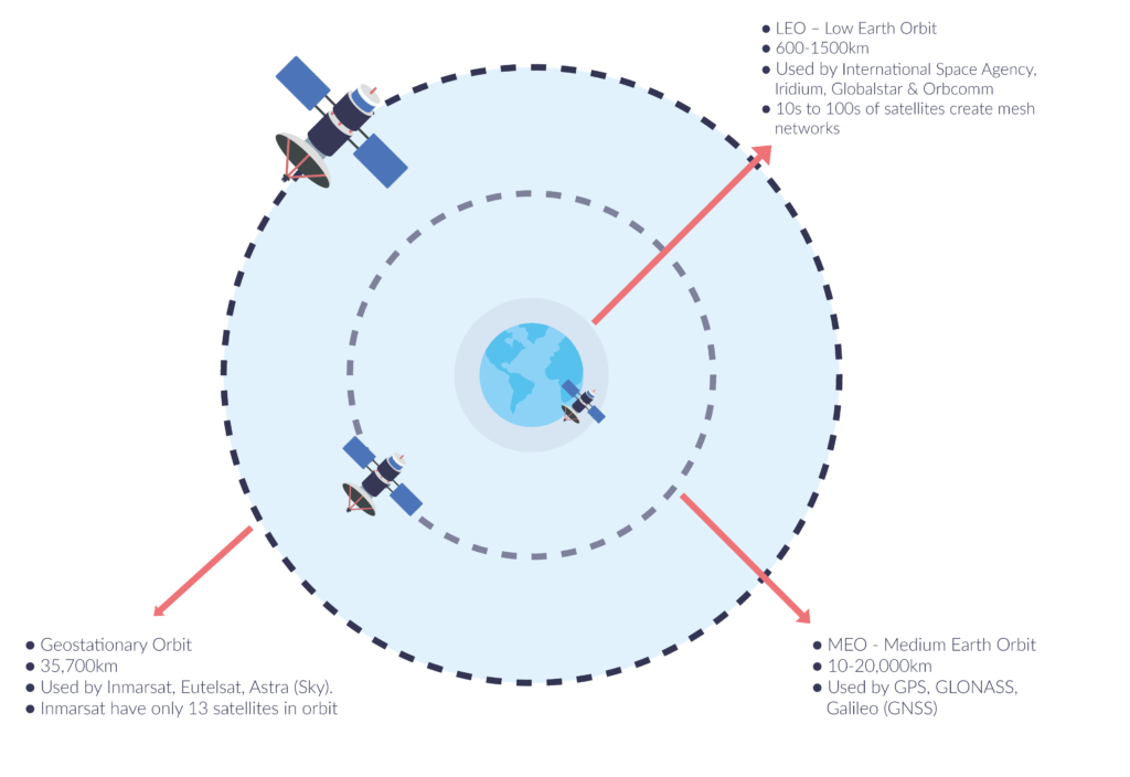
Categorised by satellite orbit height from the Earth’s surface, Low Earth Orbit (LEO) is the closest at 160 – 2,000km (99 – 1243 miles), followed by Medium Earth Orbit (MEO) which is relatively rare, with only 10% of satellites orbiting between 10,000-20,000 km from the Earth’s surface. The furthest orbit is Geostationary Orbit at 35,786 km (22,236 miles).
Satellite networks also differ based on deployment location and ground coverage area. This, to a degree, lends them to particular IoT use cases. For instance, cross-linked LEO satellite constellations offer low latency and global coverage, making them ideal for mobile applications like asset tracking. MEO satellites, with broader coverage areas, are used for global navigation and timing services. GEO satellites offer a stable, reliable connection that’s ideal for higher data rates in static use cases such as oil and gas pipeline monitoring.
Understanding the different types of satellite networks is key to choosing the right solution for your IoT use case.
LEO Satellite connectivity
Satellites in LEO orbit closest to the Earth and move quickly, taking just 90 minutes to circle the planet. These satellites are much smaller than their MEO and GEO counterparts and because of their proximity to the Earth, each satellite provides coverage to a relatively small area of the planet’s surface as it travels overhead. There are three commonly used ways to maximise coverage for satellites in LEO.
Some satellite operators – notably Iridium – create a mesh network to facilitate reliable connectivity. Satellites within a mesh network are able to communicate with one another, passing data from one satellite to another until the final destination is reached. Antennas communicating with a mesh network don’t need to be ‘pointed’ towards a single satellite, as data can be picked up by any satellite within the constellation and passed through the mesh network, to the ground station. This makes these networks ideal for mobile IoT applications, such as weather balloons or data buoys.
Another option is to have fewer satellites but more ground stations, so there are more places on Earth that can receive the data from the orbiting satellites. This allows for more bespoke local service provisions such as local network access, and is used by Globalstar and Orbcomm.
Newer entrant satellite operators have opted for a relatively large number of very small satellites (called cubesats); the sheer quantity of satellites means there’s almost always one overhead, so antennas don’t need to be pointed.
LEO satellite networks are well-suited for environmental and asset monitoring applications sending small data packets. The low-cost setup usually requires just one IoT device per modem, and service reliability is very high.
What about cubesats?
Cubesats – a form of nanosatellite – also operate in LEO. These miniature satellites are made up of standardised ‘units’ – 1U, 2U etc. indicates the size. They were initially developed for educational and technology demonstration purposes, but have now become a popular choice for a wide range of space missions, including Earth observation, communication, and scientific research.
Due to their small size and low cost, cubesats can be relatively inexpensively used to build constellations of satellites for various applications, including satellite IoT connectivity. However, their small size leads to a shorter operational life expectancy, so operators need large numbers of active and failover cubesats to ensure wide-spread and reliable coverage.
MEO Satellites
MEO satellites orbit the Earth at a higher altitude than LEO satellites, typically between 2,000 and 36,000 kilometres. As MEO satellites are comparatively larger than LEO satellites, they can cover larger areas of the globe’s surface and provide more stable connectivity. As such MEO satellites are commonly used in maritime and aviation applications, where constant connectivity is essential for safety and communication.
In addition, MEO satellites can facilitate higher data rates, making them ideal for IoT applications that require large amounts of data to be transmitted quickly, for example, video surveillance and remote sensing.
However, due to the higher altitude MEO satellites have a longer round-trip time, which can result in higher latency. Additionally, MEO satellites are more expensive to launch and maintain than LEO satellites, which can make them less accessible for smaller IoT applications.
Network operators include SES and Galileo.
Geostationary Satellites
Geostationary satellite connectivity for IoT applications involves the use of satellites positioned in a fixed spot above the earth’s equator, around 36,000 km away from the surface. This type of connectivity is suitable for applications that require high bandwidth and consistent signal coverage, such as video streaming, remote surgery, and aviation communications.
One advantage of geostationary satellite connectivity is its wide coverage area, with each satellite able to ‘see’ almost a third of the earth’s surface. This makes it ideal for providing connectivity in remote or hard-to-reach areas. Additionally, because the satellite is stationary, it can provide a constant link between the IoT device and the ground station.
However, the high altitude of geostationary satellites results in latency of about 700 milliseconds (compared to 50 milliseconds for LEO satellites), which can affect certain applications that require real-time responses. Also, because there are only a limited number of geostationary orbital slots available, the cost of launching a new satellite and securing a slot can be prohibitively expensive.
Despite these limitations, geostationary satellite connectivity remains a valuable option for IoT applications that require high bandwidth and wide coverage.
Network operators include: Viasat, Intelsat and Eutelsat.
Choosing the right type of satellite IoT
When it comes to choosing the right type of satellite IoT, there are many factors to consider. At Ground Control, we tend to take our customers through the following questions to help them narrow down their options:
- How data intensive is your application?
- How time-critical is receipt of your data?
- Where are your assets located?
- Are your assets fixed or mobile?
- What level of data security is required?
Though that isn’t a comprehensive list, it should be enough to guide some initial investigations.
We understand that navigating the world of satellite IoT can be daunting, which is why our team of experts is always on hand to answer your questions and help you choose the right solution for your business. Contact us today at hello@groundcontrol.com to learn more about how we can help you connect anywhere in the world.
Looking for a satellite connectivity partner?
Having partnered with satellite network providers such as Iridium and Inmarsat for well over a decade, we have access to competitively priced tariffs, and can also be very flexible in terms of bundled data.
So if you are working on an IoT project and would like some no pressure, objective advice, simply fill in the form and one of our expert team will get back to you.
LoRaWAN Data Backhaul Using Satellite Connectivity
In this post we’re exploring your options for wireless connectivity of IoT devices, and the differences between NB-IoT and LoRaWAN. We’ll see how LoRaWAN and satellite connectivity can work together to maximize coverage, connectivity, and cost control.
Why choose LPWAN as a wireless solution for widespread IoT devices?
This chart, courtesy of You Li, outlines the major technologies in place for the wireless connection of IoT devices. In short, if you need to transmit data wirelessly between sensors and gateways over a large area, you have the choice of cellular or LPWAN connectivity.
Cellular, however, is both expensive and power hungry, and carries the risk of the technology being retired (e.g. 2G and 3G networks being phased out). Further, only 15% of the Earth’s surface is covered by cellular networks (source: World Economic Forum).
LPWAN (Low Power Wide Area Network) technologies have a lot of plus points: battery lives that span years; low cost; long range. Only very small amounts of data can be transmitted, but that’s adequate for environmental monitoring, asset management, tracking, metering etc.
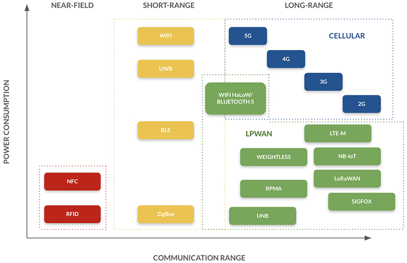
Within LPWAN there are many technologies and standards, and IoTForAll has an excellent article explaining the pros and cons of the main options. We’re summarising the most popular choices here.
LTE-M is USA-centric, but offers higher data rates than many, and cuts across borders with ease, so it’s good for mobile applications.
NB-IoT transmits less data but equally consumes less power; it’s generally lower cost, and more widely available outside of the USA than LTE-M. However it’s not yet effective for mobile use cases as it requires roaming agreements between different telco providers. It communicates with the cloud directly, unlike LoRaWAN which requires end nodes to transmit data to a gateway first, and from there to the cloud; this makes networking of NB-IoT easier (source). NB-IoT also offers the greatest wireless reach, with devices able to communicate wirelessly over distances as great as 22 km. This is dependent on location – NB-IoT works well in cities but is less stable in rural areas where cellular / wifi connectivity is limited.
LoRaWAN – which combines the standard for the physical layer (called LoRa), plus the MAC layer and application standards – is also typically used for static communication scenarios such as soil moisture sensors, water levels and quality, gas / oil pipeline monitoring and glacial melt. Because public networks extend across broad geographic regions, LoRaWAN can be used for some mobile IoT applications such as fleet monitoring and animal tracking too. Telecom operators operate public LoRa networks, but you can also set up your own private network relatively inexpensively. Wirelessly connecting devices up to 16 km apart, LoRaWAN has no dependence on cellular or wifi, and so offers relatively stable coverage in rural and remote areas (source).
LPWA connection share by technology, 2020-2025
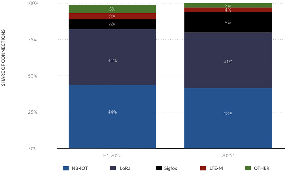
By 2025, it’s anticipated that on a global scale, NB-IoT and LoRa will, between them, have 84% of the share of LPWA connections (Statista).
Where does satellite IoT come into the picture?
All of the LPWAN technologies need to be able to transmit their data to the cloud, and if they operate far outside of cellular or wifi coverage – i.e. in very remote locations such as mountains, oceans, deserts and forests – they need a mechanism for data backhaul.
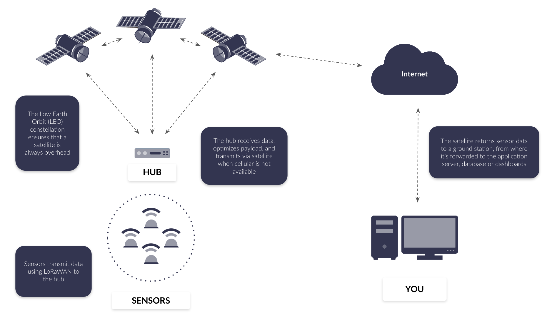
In this example, sensors are transmitting data using LoRaWAN to the hub, or gateway. The hub receives the data, optimizes the payload (this is important to keep data transmission costs down), and will transmit the data via satellite if cellular is not available.
In this example, we’re using a satellite constellation in Low Earth Orbit – Iridium – which has 66 satellites overhead, ensuring that 100% of the globe can connect with their satellite network. The satellite returns the sensor data to a ground station, from where it’s forwarded to the application service, database or dashboards.
Iridium is a great choice, but there’s no reason in principle why you couldn’t also transmit to a geostationary satellite network such as Inmarsat, as long as your gateway or hub has line-of-sight to the satellite.
One of Ground Control’s customers is using this method to capture sensor data from a remote reservoir in Wales, UK. The automated monitoring system is designed to alert engineers to potential equipment failures, to minimize the need for unplanned maintenance visits. Challenges included the lack of mobile phone coverage, no provision of a telephone line or ADSL connection, and a wide area distribution of a large number of sensors. A cabled solution was quickly ruled out due to the logistical challenges, time and cost implications. The solution: using satellites to backhaul LoRaWAN network data.
Where else can you see satellites and LoRaWAN working together?
- Agriculture for a wide range of monitoring applications including nutrients, soil temperature and moisture levels or keeping tabs on water quality
- Mining for monitoring the status of tailings storage facilities (TSFs), resource and pipeline monitoring
- Transport and logistics to track end-to-end to reduce supply chain losses or monitor vehicles to prevent theft
- Environmental agencies to monitor everything from deforestation to ocean plastic
- Oil and Gas for pipeline and offshore site monitoring
- Renewables for solar array and wind farm monitoring.
Recommended satellite terminals for LoRaWAN data backhaul
If your use case is static and not in the polar regions, Viasat IoT Pro service will meet your needs, with its tried and trusted geostationary satellites. The Cobham Explorer 540 or the Hughes 9502 are both reliable and economical devices which can be solar or battery powered.
A robust option which will work for both static and mobile applications is the truly global Iridium satellite network. Iridium has two airtime options for IoT data – Short Burst Data (SBD) or Certus 100. SBD is a message-based platform and can transmit payloads of up to 340 bytes up, 270 bytes down. This isn’t usually enough for aggregated data from a LoRaWAN gateway. If you need more capacity, or an IP-based solution, Certus 100 offers both: an IP transmission option at 22 / 88 Kbps, or a message-based option (called IMT) capable of 100kB / message.
For Certus 100 we’d recommend RockREMOTE Rugged for full edge processing capabilities, and cellular + satellite connectivity, or RockREMOTE Mini / Mini OEM for a simpler, pared back solution.
Would you like to know more?
If your sensors are widespread and in a remote area without terrestrial connectivity options, we can help! Solving remote connectivity challenges is what Ground Control exists to do.
Call or email us, or complete the form, and one of our expert team (we’ve been doing this for over 20 years) will be in touch to discuss your options.
The Role Of 5G And Satellite Technology In Industry 4.0
Industry 4.0, alias, Fourth Industrial Revolution, describes the integration of advanced technologies such as the Internet of Things (IoT), Artificial Intelligence (AI) and robotics, quantum computing, genetic engineering and more. It represents a shift to a more connected world, whereby the lines between the digital and physical are blurred.
Also referred to as Smart Industry, Industry 4.0 is transforming businesses, enhancing and optimising operations with real-time monitoring and control, and enabling new business models, for example, mass customization.
Cisco’s Annual Report predicted there would be almost 30 billion connected devices by 2023 and Statista estimated 15.1 billion would be IoT connected devices. Though we are still scratching the surface of the possibilities open to us as a result of IoT and Industry 4.0, more generally, all of these technologies and outcomes are dependent on connectivity. Without connection, the insights available via data transmission and analysis remain elusive.
Meeting the demands of a connected world
In order to support this increasingly connected world, governments and organizations have largely focused on building out high-speed broadband networks, expanding wireless coverage and investing in smart city infrastructure. Though some parts of the globe have made significant progress, not least those in developed countries, there are still substantial gaps. At the beginning of 2023 it was estimated that just 64.4% of the global population had access to the internet.
In November 2022, the UK government pledged £5 billion to deliver gigabit-broadband to a minimum of 85% of premises by 2025 and the original target of ‘nationwide’ was pushed back to 2030.
The role of 5G in Industry 4.0
5G’s role in the future of Industry 4.0 is significant. 5G enables a much larger number of connected devices to operate simultaneously, with faster response times and higher levels of reliability. This is particularly important for IoT applications that require real-time data processing, such as smart city infrastructure.
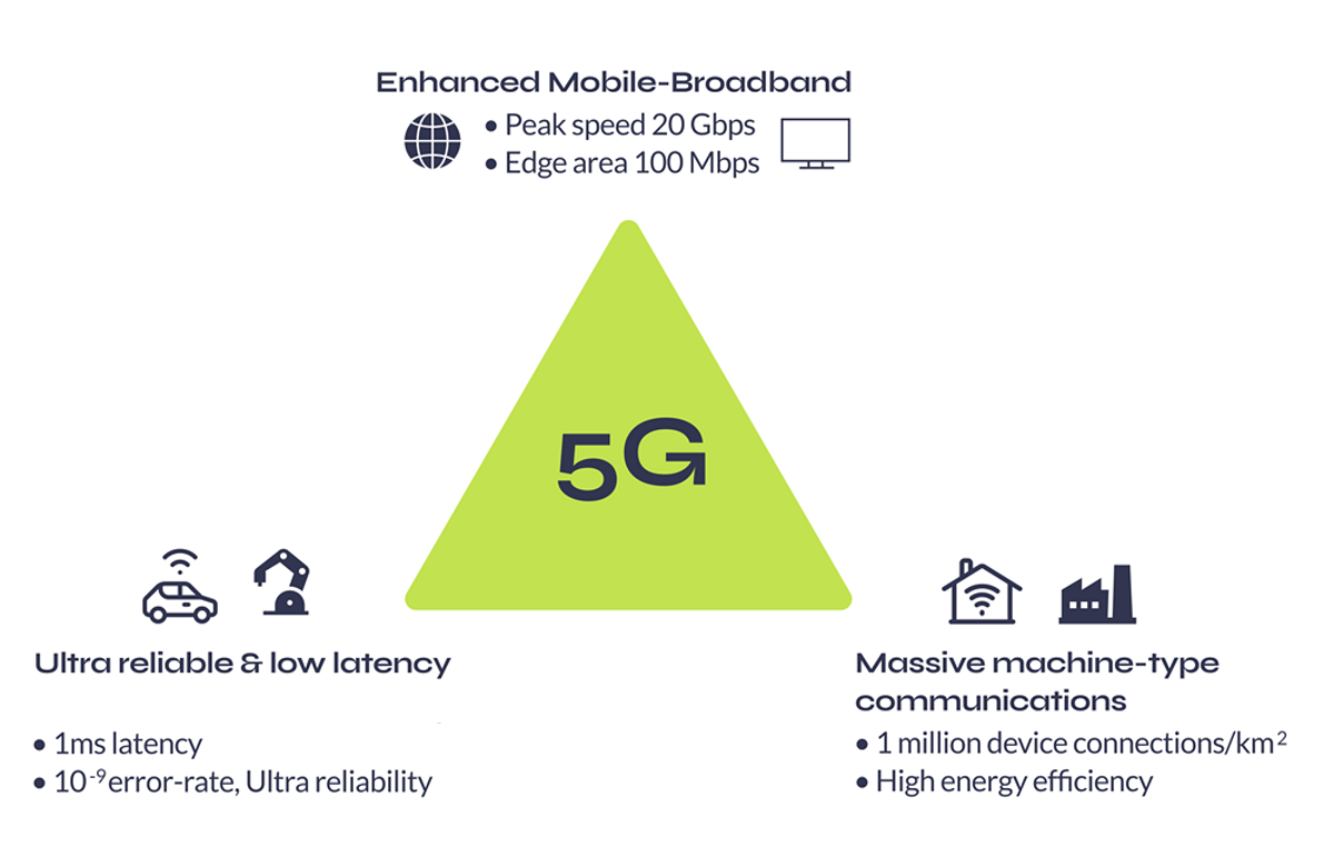
The 5G triangle represents the full spectrum of capabilities, from high speed data transfer to low latency connectivity for mission critical applications, and efficient connectivity for the large number of IoT devices that will be connected to the network.
1. Enhanced Mobile Broadband (eMBB)
Fast data transfer, low latency
Data transfer speeds up to 20 Gbps and latency as low as 1 millisecond
Use cases: High bandwidth applications, for example, video streaming and virtual reality.
2. Ultra-Reliable Low Latency Communication (URLLC)
Low latency, high reliability
Latency as low as 1 millisecond and reliability of up to 99.999%
Use cases: Mission-critical applications such as autonomous vehicles.
3. Massive Machine-Type Communication (mMTC)
Low power, low bandwidth
Designed to support up to 1 million devices per square kilometre
Use cases: Applications with a high volume number of devices. For example, automated supply chain management, infrastructure for smart cities.
In addition, 5G can help to address some of the key challenges facing IoT, such as security and privacy, by providing more robust and reliable connectivity.
However, though 5G is capable of delivering broadband across short distances, it was designed to enhance coverage in urban regions with dense populations – not for rural, remote areas. 5G is currently sitting at an 8% global adoption rate, with terrestrial networks more widely covering just 15% of the globe. It’s clear telecommunications infrastructure alone cannot support this new, interconnected world.
As Tom Stroup, President of the Satellite Industry Association explains – “We’ve seen a recognition that many of the things that are desired by 5G can only be achieved with the ubiquitous coverage that satellite networks provide.”
The future of 5G: Satellites
Though connectivity is about more than coverage, one of the primary benefits of leveraging satellites in 5G networks is 100% global coverage. Unlike traditional mobile networks or fibre connectivity which rely on infrastructure, satellites can provide coverage anywhere and everywhere on Earth.
Another advantage is that Low Earth Orbit (LEO) satellites can deliver low latency, high speed connectivity. Latency is an important consideration for time critical applications such as remote surgery or autonomous vehicles where delays could lead to severe consequences. As LEO satellites are positioned between 160 – 2,000km (99 – 1243 miles) from the Earth’s surface, latency can be as low as 20 milliseconds which is comparable to that achieved via terrestrial networks. Moreover, the additional bandwidth would place 5G networks in the best possible position to accommodate ever increasing data traffic and number of connected devices.
Ultimately satellites could be used to complement 5G networks in three main ways:
- Expanding coverage to include rural, remote areas,
- Creating redundancies, and
- Additional backhaul.
Though it’s likely the role of satellites will look slightly different depending on the country and region and thus bandwidth and coverage already available, if successful these could lead to several additional business models.
But the how is slightly more complicated. Interoperability isn’t a new conversation within the communications industry but it wasn’t until 2017 that a formalized working group recommended 5G technology should be able to integrate non-terrestrial networks (NTN) such as fibre and satellites. Fast forward to July 2020, 3GPP Release 16 began to address this challenge.

What is 3GPP?
The Third Generation Partnership Project (3GPP), is a collaboration between various telecommunications standards organizations. The main focus of the 3GPP is to develop specifications for wireless communication systems, including 2G – 5G technologies. These specifications include protocols for cellular networks, as well as guidelines for interoperability between different devices and networks, including non-terrestrial networks.
3GPP Release 16: Benefits and shortfalls
Release 16 outlined multiple significant improvements not least, access technology standards for using higher frequency New Radio, supporting greater signal bandwidth and lower latency. Of those relating to interoperability, dual connectivity was extended to support NTN. Meaning in theory satellites could connect assets in rural areas where cellular coverage was limited and integrated access and backhaul was named as an area of study.
Despite these improvements, there were some associated shortfalls. One of the main challenges with 5G over satellite is latency. While as previously mentioned, Low Earth Orbit (LEO) satellites can achieve latency times as low as those associated with cellular, this isn’t always possible.
For geostationary (GEO) satellites, which are located roughly 34,000km above the Earth’s surface vs LEO’s 160 – 2,000km, the round-trip time is longer; closer to 270 – 540 milliseconds. As Release 16 didn’t account for this, it meant satellite operators needed to develop their own solution to mitigate potential latency issues.
What’s more, Release 16 didn’t account for mobility issues. This is more applicable to LEO satellites as these networks create a mesh of satellites around the globe and pass data as required between satellites and various ground stations. Particularly in the case of asset tracking applications where assets are moving, mobility and thus handing data from one satellite to another, becomes more important.
While Release 16 defines the interfaces between the UE and the core network, it does not provide detailed guidance on how to handle handovers between terrestrial and satellite networks. This can result in disruptions to the user experience as the UE moves between different network environments.
Ultimately Release 16 highlighted the importance of collaboration. Just one great example formed following Release 16 is that between Inmarsat and MediaTek in late 2020.

Their collaboration involved a successful field trial which ultimately contributed to 3GPP’s Release 17 standardization work on NTN. Utilising NB-IoT technology, a bi-directional link from MediaTek’s satellite-enabled narrowband service to Inmarsat’s Alphasat L-band GEO satellite was established. As Jonathan Beavon, Senior Director at Inmarsat concluded – “testing MediaTek’s standard NB-IoT chip over Inmarsat’s established GEO satellite network has proven technology from mobile networks works effectively over GEO satellites with little modification and will provide a very cost effective path to ubiquitous and hybrid global IoT coverage.”
Release 17
In 2022, 3GPP Release 17 marked the most recent standard for 5G Networks and was the first to outline technical specifications for direct-to-device 5G over satellite.
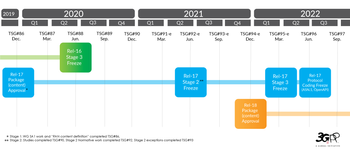
Specifically addressing interoperability, Integrated Access and Backhaul (IAB), and network slicing were extended to support NTN. The former, IAB, is particularly relevant for satellite operators as it helps address issues associated with latency by providing a more direct connection between device and satellite. Network slicing on the other hand is best exemplified by applications such as smart cities. Network slicing enables specific applications within the wider smart city network to utilize allocated network slices. So in the case of traffic monitoring and management, prioritising the utilization of a low latency, high bandwidth network slice ensures this application is better supported.
Release 17 also included additional features for dual connectivity. These cover support for more advanced network slicing configurations, which can help to improve the efficiency of network resources.
Moreover, Release 17 outlined enhanced support for Low Earth Orbit (LEO) satellites. Mobility issues were addressed by new features such as satellite handover, enabling seamless connectivity as devices move from one satellite to another.
The future of wireless communications
Release 17 was the first to position satellites as a critical component of the 5G ecosystem. Though this is a significant step forward, introducing new technology into any architecture is not something which can be achieved overnight and in the case of satellites, there are two relatively large challenges to integration: regulatory and capital. There may be regulatory issues related to spectrum allocation and licensing and there are well documented business challenges related to the cost of deploying and operating satellite networks.
In the case of satellites, it’s not quite as simple as changing a SIM or updating firmware over the air. Satellites are largely programmed prior to launch. In most cases it would mean launching additional satellites within a constellation to add the technology required to support these interoperability features.
If for example, satellite operators had incorporated 2G or 3G network technology, both of which are now in the process of sunsetting, those additional features would be becoming redundant. In short, there are benefits to maintaining proprietary technology and this is how many of the longer standing satellite operators have conducted business.
Currently many of the in-built phone functions depend on 5G NTN technology. However, despite the noise the reality of integration is slow. Qualcomm’s new Snapdragon X75 chipsets, leveraging Iridium’s satellite network are due for sampling in Q2 of 2023 (now), with expected select shipping estimated for Q3 and 4. Other companies, including Apple have demoable tech which incorporates NTN using Qualcomm X65 chipsets but this is limited to one usable band – n53.
In short, while advances are exciting and once this tech does land it’s expected to be very disruptive, we are still very much in the early stages of development. So the exact role of satellites within 5G architecture and Industry 4.0 more generally is unclear.
What is clear however, interoperability is top of mind for many just now. Just this week, 13th March 2023, Iridium’s CEO Matt Desch hosted a session at the SATELLITE 2023 event titled The Satellite-Cellular Convergence – A New Era for the Telco Industry?
The last few years within the satellite industry has seen incredible growth and innovation but not all new players entering space will be here for the long term. Just as not all technology within the 3GPP standard – NB-IoT (Narrowband Internet of Things), LTE-M (Long-Term Evolution for Machines), 5G NR – will be here for the long term. The challenge now lies with satellite operators and bodies such as 3GPP to create and maintain technology standards which all players can bet on. Ultimately, the only way we will achieve a fully connected world capable of supporting Smart Industry is with both 5G and Satellite technology because without connection, nothing is smart.
Ready to unlimit your IoT application…
… But not sure where to start? We can help. Interoperability can be a real challenge for those with IoT projects. Having partnered with satellite network providers such as Iridium and Inmarsat for well over a decade, we have access to competitively priced tariffs, and almost all of our products allow dual connectivity.
So if you are working on an IoT project and would like some no pressure, objective advice, simply fill in the form and one of our expert team will get back to you.
How Satellite IoT Closes The Gap in Remote Wind Turbine Data Monitoring Challenges
The renewables landscape is changing. The International Energy Agency (IEA) reports that the ‘global energy crisis has triggered unprecedented momentum behind renewables, with the world set to add as much renewable power in the next 5 years as it did in the past 20’.
The rise of renewable energy and the pitfalls of unplanned maintenance
Partially due to Russia’s invasion of Ukraine, countries are increasingly motivated to invest in renewable energy technologies to reduce reliance on imported fuels. Wind and solar energy in particular will account for over 90% of the renewable power capacity that is added globally over the next five years, according to the IEA.
So what does this mean for wind power in Europe?
Solar and wind power generated more than a fifth (22%) of its electricity in 2022, pulling ahead of fossil gas (20%) for the first time, according to the European Electricity Review 2023. However, many wind farms are located in remote areas and have limited resilience against severe weather, power outages and downtime due to unplanned maintenance.
In the case of the latter, often, renewable energy providers rely on physical onsite maintenance to restore energy production, requiring significant resources, time and cost. It presents energy providers with a big challenge. Research by Wood Mackenzie Power into renewables in 2019 found that $8.5 billion was spent on unplanned repairs and corrections caused by component failures in wind operations.
This cost could be lowered and potentially avoided if sensors for predictive maintenance were operable, and the data generated is available consistently and in close to real-time. It’s an area where satellite IoT connectivity makes economic sense.

How SCADA data helps keep the turbines turning
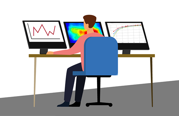
For each wind farm – onshore or offshore – SCADA (supervisory control and data acquisition) data is reported. This includes weather data such as wind direction, various turbine parameters, and errors encountered by the system, normally at 10-minute intervals.
It’s this historical SCADA data that provides invaluable insights to generate a robust approach to monitoring turbine performance, identifying patterns and predicting failures for better predictive maintenance planning and less downtime. Via satellite-driven data monitoring, renewable data intelligence is delivered in seconds. This enables engineers, maintenance managers and data scientists the ability to plan, predict and act to close the gap in remote wind turbine data monitoring challenges.
Why there’s a better way than cellular, fiber and onsite personnel
Unlike cellular and fiber connectivity – which in many cases is not a feasible solution due to the remote locations of wind farms – satellite IoT is truly global. Satellite connectivity ensures reliable remote data monitoring from individual turbines to entire wind farms allowing optimization and ongoing performance assurance of wind energy output.
IoT Pro terminals (previously known as BGAN M2M) are designed to connect monitoring and control applications in remote, unmanned locations like wind farms, to provide visibility and management of those assets. Remote management of the terminal can be achieved via SMS, eliminating the reliance on on-site maintenance crews, mitigating unplanned downtime and saving costs.
As an example, an experienced Field Engineer has a day rate of approx. 350 euros plus fuel, company vehicle maintenance and overtime. In contrast, the cost of operating a Viasat-enabled satellite connectivity terminal can be as little as 60 euros per month for up to 20MB; not only is this a clear saving over physically sending an engineer into the field, the data is available in close to real-time, all the time.
SCADASat by TSAT enables renewable providers to cost-effectively and reliably transmit remote SCADA, telemetry and M2M data – all in a secure network. The platform is highly scalable with low operating costs compared to the new installation and maintenance of fiber connectivity. It is compatible with both IP and legacy serial devices and operates independently from terrestrial communications systems, both complementing and offering an alternative solution to terrestrial networks, ensuring transmission at all times.
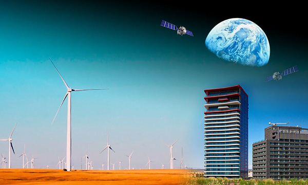

How satellite IoT closes the gap with IoT Pro
Operating on both Viasat IoT Pro and cellular 2G/3G/LTE networks, these devices keep data flowing to enable predictive maintenance.
While wind farm resilience against severe weather will continue to be tested, the challenges of power outage predictions and production downtime due to unplanned maintenance can be solved via the adoption of IoT Pro solutions.
How we can help overcome your data monitoring challenges
Ground Control can solve renewable energy monitoring challenges with satellite IoT. We help our customers achieve an accurate, real-time, 360 view of their data and operations; anywhere and everywhere. If you’d like some impartial advice on the best device and airtime for your data monitoring requirements, get in touch. With 20 years’ of experience, we’re confident we can help.
Would you like to know more?
We’re here to help. With highly experienced staff based in the UK and USA, we’re here to talk through your most challenging remote connectivity requirements.
Complete the form, or if you prefer to speak to someone directly, call us on +44 (0) 1452 751940 (Europe, Asia, Africa) or +1.805.783.4600 (North and South America).
5 Steps To Reducing IoT Connectivity Costs
Connectivity is often identified as a barrier to IoT deployment success. Inmarsat’s 2023 Enterprise Insights ranked access to reliable IoT connectivity as a top challenge with over one third reporting difficulties (34%); and 33% struggling to implement IoT solutions in remote locations.
To harness the full value of IoT enablement, terrestrial, fibre and Long Range Wide Area Networks (LPWAN) are vital. But these networks are limited. Covering approximately 15% of the Earth’s surface, they do not provide the global coverage essential to capture all data points and fail to capture valuable insights from the most remote locations. This is where satellite IoT connectivity can help.
A staggering 91% of businesses surveyed by Inmarsat believe satellite connectivity is key to improving the effectiveness of IoT solutions. But many still consider satellite connectivity expensive. Our response? It’s far more cost-effective than you might think.
How to reduce Satellite IoT connectivity costs
IoT applications consist of multiple, connected devices which collect and analyse data in real-time. Applications dealing with mission critical data often also have devices intended for failover comms in the event that their main form of connectivity fails. To maximise project value, reliable connectivity is essential.
Since connectivity costs are largely based on the volume of data sent, optimising data mobility can significantly reduce overall connectivity costs while maintaining maximum project value. Below are 5 ways businesses can reduce their overall satellite airtime costs:
- Remote terminal management
- Real-time data management
- Determine required data for each application
- Diversify connectivity options
- Edge computing
1. Remote terminal management
To keep operational costs low, designing a network which minimises manual intervention is key. Understandably then, many organisations with devices in remote locations will activate terminals and set these to always-on. Though this is rarely required, physically sending engineers to deactivate/reactivate terminals wouldn’t be worthwhile. But for companies who are able to control terminals remotely, for instance, deactivating devices when applications aren’t live.
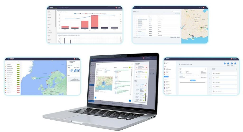
Some companies offer platforms which allow remote activation, suspension, and deactivation. Often these platforms will allow companies to either leverage the API to integrate this service into their own platform or use an online UI to manage their device portfolio, irrespective of device location. In the case of Ground Control, this is managed through our platform Cloudloop. Available via a customer-friendly UI or integrated directly into your business’s ecosystem, Cloudloop puts users in control of their devices and data.
2. Real-time data management
Typically customers benefit from better data rates within service plans as opposed to pay-as-you-go options. So accurately predicting and then choosing the right data plan for each device before you start using it is an easy way to make sure you’re getting the best rate for your airtime. The other benefit is avoiding overage charges: these are applied if companies go over their allocated data allowance and are usually more expensive than the contracted rate. Again, having a well defined view of your data requirements will minimise the amount of times you incur overage costs. If this is a relatively new IoT deployment, companies will likely need to make an educated guess. For those who feel less confident doing so, we recommend you speak to connectivity providers with experience of similar setups so they can advise on likely usage.
Moreover certain airtime and hardware providers offer data management services, allowing organisations to monitor device data usage in real-time. These help businesses avoid bill shock, making appropriate adjustments in real-time and identify if there is a particular device significantly above or below expected use. The latter can be used to help detect early signs of equipment failure or potential security breaches, so companies can take proactive measures.
3. Determine required data for each application
Many businesses apply the same data transmission settings across all devices, all applications. Instead, adjusting settings based on actual application requirements can have a considerable impact on overall connectivity costs. For example, if you choose to send sensor data every 15 minutes but the application only requires data input once an hour; or is only monitoring data to ensure levels remain within specific parameters, you’ll be paying for unnecessary transmissions.
- Frequency of data packets First, consider whether your project or application could tolerate a longer delay between data packets. For some applications it’d likely make little to no difference. Trial adjusting settings so instead of data being sent/received every 15 minutes, this becomes every 30 minutes or even once an hour.
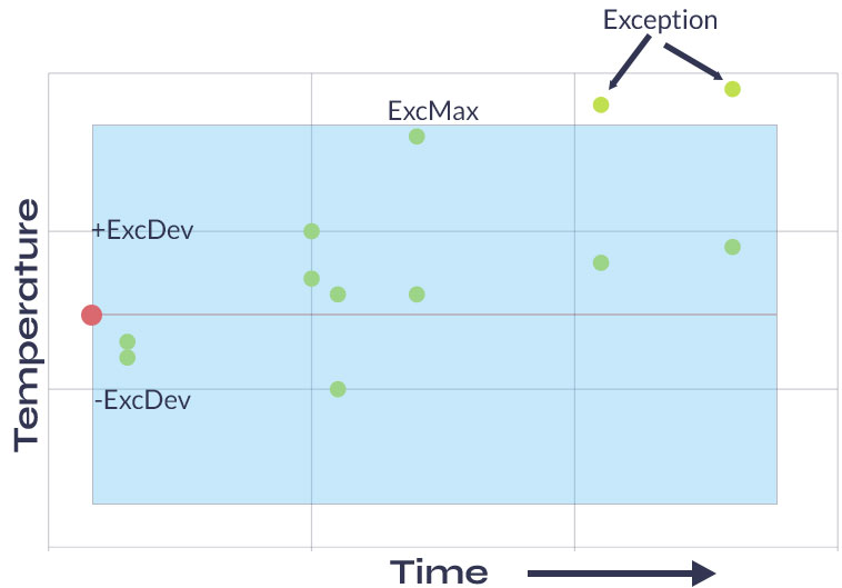
- Reporting on exception Second, does your company require all sensor data? A lot of the data involved in IoT applications verifies that operations are running as expected. Instead, can you configure your system and/or devices to only send data that falls outside set parameters – reporting on exceptions. Not all devices have this functionality but even incorporating a small number capable of supporting exception reporting like the RockREMOTE can lead to a substantial reduction.
4. Diversify connectivity portfolio
The satellite communications industry has seen incredible growth and innovation in the last few years. As such, the options available for both networks and services within those networks have diversified.
For businesses with IoT projects already up and running it’s worth reviewing satellite airtime plans; can cost savings be achieved through simple renegotiation, could assets within your network be switched to alternative more cost-effective services? There are multiple nuances to consider but the savings could be substantial.
One of the most important considerations is regarding message packet size. When utilising Iridium Certus 100, the minimum cost per session is 5KB allowing for a maximum of 20 sessions within (for example) a 100KB monthly bundle. In contrast, with Iridium’s Short Burst Data (SBD) service the minimum is just 10 bytes, meaning users could send 10,000 message packets. Depending on your application’s data requirements this could have a substantial impact. Though SBD is limited to a total of 340 bytes up and 270 bytes down, this is ideal for most asset tracking applications and often one of the most cost-effective satellite services.
For those who need to cover more complex telemetry projects for instance, in the Utilities sector, it’s more likely setups will leverage Viasat’s IoT Pro service (previously known as BGAN M2M). In these situations more practical measures such as ensuring terminals are accurately pointed, reducing the likelihood of message packets being dropped, can help reduce overall costs.
If you do have any specific queries related to airtime, please don’t hesitate to get in touch. We’ve been doing this for over 20 years and though we have significant relationships with both Iridium and Inmarsat we’re not tied to any one provider, just helping you find the best solution for your project and budget.
5. Edge computing
Edge computing is an emerging computing paradigm, which has arguably become a bit of a buzz term. In short, it allows companies to process data where the data is being generated – at the edge. This reduces overall data transmission, for example, to the cloud. Though data processing within the cloud has become popular in recent years, to achieve this, companies must first employ the relatively expensive transport mechanism of getting all data to the cloud. Instead, with edge computing, businesses can be more efficient with the volume of data sent, conducting some processing locally.
Again, not all devices are able to facilitate edge processing and typically companies with more established IoT deployments may have hundreds, if not thousands of units. So though it might not be economical to replace all units, in situations where terminals are reaching end of life or those organising a new IoT deployment, choosing edge-computing-capable devices could be worthwhile. Edge-computing-capable devices can reduce overall connectivity costs and extend the life of other units within the network. So even a relatively small investment could prove beneficial.
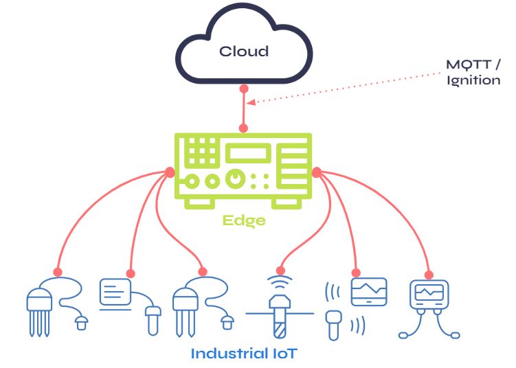
As satellite technology advances with the likes of nanosats, it’s likely satellite communications will continue to become more cost-effective and services more diverse. In the meantime there are many tactics companies can employ to optimise data mobility and thus reduce satellite IoT costs.
If you or your team would like any advice on the best network or service fit for an IoT application, or would like to review your satellite IoT airtime costs, simply fill in the form below and one of our team will get in touch.
Ready to unlimit your IoT application?
Having partnered with satellite network providers such as Iridium and Inmarsat for well over a decade, we have access to competitively priced tariffs, and can also be very flexible in terms of bundled data.
So if you are working on an IoT project and would like some no pressure, objective advice, simply fill in the form and one of our expert team will get back to you.
When is Viasat IoT Pro the right satellite IoT solution for you?
Satellite IoT is rapidly moving from a niche service used by the wealthy few to an integral part of a broader IoT ecosystem. Its ability to transcend terrestrial constraints (e.g. roaming agreements and infrastructure) and provide seamless, reliable, continuous coverage on a global scale makes it invaluable in remote IoT applications, and as a backup to cellular / fibre-based connectivity.
The reasons for using satellite IoT haven’t changed in the last decade, but its take-up has grown dramatically, and is projected to continue to do so. A 2021 report from IoT Analytics estimated that the number of satellite IoT subscribers would grow from 5.1 million in 2021, to 13.5 million by 2026. One factor in the increased adoption is the larger number of options available to systems integrators: both from new entrants into the space (pun intended!) and from established players offering more diversified services. This has made the cost of sending IoT data via satellite viable for most applications.
Which is all great news for IoT engineers, but also makes the task of choosing a network and service within that network considerably more complex! The Ground Control team are here to help you navigate your options, so do contact us if you need any help; this post is aimed at helping you understand if Viasat’s IoT Pro service (previously known as Inmarsat’s BGAN M2M service) would meet your needs.
Here are 4 instances in which Viasat IoT Pro is an excellent choice for your satellite IoT connectivity.
1. You have quite a bit of data to transmit
The IoT Pro service offers data speeds of up to 464 Kbps, which is ample for most IoT applications. This will allow you to transmit not just multiple sensors’ data but images and even video, so it’s ideal if you have remote surveillance / security requirements, for example.
2. You need an IP-based service for ease of integration
IoT Pro isn’t the only IP-based satellite IoT connectivity solution (see also Iridium Certus 100) but it is tried, trusted and very reliable with 99.9% network availability. While IP-based services are more data-hungry than message-based services, they have the benefit of being pretty much plug-and-play, and it’s possible to optimise your transmissions to manage costs better.
3. You need a highly cost-effective solution
Ground Control is Viasat’s first ELEVATE partner, which means we’ve access to great airtime rates for the IoT Pro service. But even if that wasn’t the case, IoT Pro is one of the most economical IP-based services available. Plus, many devices which utilise the IoT Pro service are hybrid, able to switch between cellular and satellite depending on network availability. The Explorer 540 is a great example; this means you get continuous coverage but lowest cost routing.
4. You need a solution for use in hazardous environments
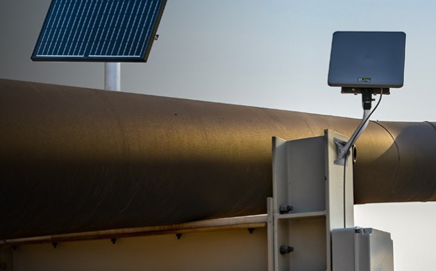
This isn’t a feature of IoT Pro per se, but it just so happens that Cobham and Hughes, our trusted partners for IoT Pro-enabled devices, have C1D2 certified products available – the Explorer 540 and the Hughes 9502 series. This is essential for many Oil and Gas users, as the certification is designed to prevent explosions and ensure worker safety.
When wouldn’t you use IoT Pro?
1. If your data is in the polar regions
At the time of writing, Viasat has five satellites in geostationary orbit, covering most, but not all, of the globe. The polar regions aren’t covered, so if you have data collection requirements there, look at Iridium services instead. You can see a coverage map and learn more about Viasat’s development plans here.
2. If you need extremely low latency
Viasat’s satellite network is in geostationary orbit at 35,786 km above Earth. This means the time taken for a signal to be sent from your remote antenna to the satellite, then back to the ground station and from there to your system, is about 2 seconds. That’s not a lot, but satellites in low earth orbit (LEO) are orbiting the earth at approx. 780 kms, so the data has much less far to travel, and the latency is <1 second. If that’s a requirement for you, look at the Iridium service as an alternative. Here’s some more information about satellite orbit heights and how they impact connectivity.
3. Potentially, if your data logger is in a mountainous or forested area
IoT Pro antennas need to be pointed at one of the satellites in geostationary orbit. This is a simple process; many of the terminals either auto-point or provide you with helpful beeps or LEDs to demonstrate when you have the optimal look angle. And once they’re locked on, it’s a very stable connection. However, if your remote sensor array is in a mountainous or forested area, it’s possible that you will struggle to find a look angle that allows you to connect with the satellite. This is fairly uncommon but if you’re unsure, have a chat with one of the Ground Control team about your location, and we’ll be either able to provide you with advice based on Google satellite images, or we can help you test devices in the field to make sure you get a strong, stable connection.
We hope this is helpful, but would encourage you to speak to us if you need any advice on the best device and airtime for your needs. Thanks for reading!
Get in touch
We’ve implemented satellite IoT infrastructure for decades, and there’s very rarely been an obstruction issue we couldn’t overcome with a bit of knowledge and ingenuity.
We’d be happy to talk to you about your project and offer impartial advice on the best antenna and satellite service for your particular requirements. Call or email us, or complete the form.
Ground Control Recognized as Top 10 Oil & Gas Solution Provider
We’re delighted to announce that Ground Control has been recognised as one of the Top 10 Oil & Gas Solution Providers in 2022.
We have always taken pride in being a partner that truly understands both ends of data communications. Taking ownership of the overall solution and working with our customers to identify not just required volume and frequency of data transmission, but what device compatibility is required and how the data is to be used; to achieve operational goals. We have been creating and delivering advanced connectivity solutions to the Oil & Gas industry for over 20 years.
Solutions for the Oil & Gas sector
We deliver remote connectivity solutions to power Oil & Gas IIoT applications and support global, off-grid operations. Simply put, our solutions help to deliver more reliable data, better safety, cost management and enhanced security.
Popular use cases include remote monitoring and control, pipeline management, asset tracking and lone worker enablement and safety; and facilitating each, is robust, advanced connectivity.

The real value of connectivity
From asset management through to remote performance monitoring and maintenance, the IIoT ecosystem is delivering efficiencies and productivity to meet the demands of an ever-evolving energy landscape.
McKinsey & Company project that advanced connectivity to optimise drilling and production throughput and improve maintenance and field operations, could add $250 billion to the industry’s upstream operations by 2030.
This focus on connectivity, as opposed to IIoT more generally, is key. Despite the myriad of measurable benefits IIoT offers, everything will fall at the first hurdle if connectivity isn’t addressed as a priority. Data enables smarter and faster decisions, but data gaps and interruptions can lead to poor, costly business decisions. To truly harness the value of digitalisation in the field, operators must maintain near real-time, reliable data delivery from all assets within the Oil & Gas supply chain, at all times.
Given the often hostile and remote nature of the environments in which Oil & Gas plants are situated, terrestrial connectivity is not always available, nor reliable. This is where Ground Control really adds value. Using cellular and satellite networks, we specialise in connecting hard-to-reach people, machines and things.
Introducing Iridium Certus® 100
Ideal for IoT and M2M applications, the Iridium Certus® 100 service is facilitated by Iridium’s constellation of 66 LEO satellites. Providing pole-to-pole coverage, with the benefit of lower latency.
Offering IP data speeds of up to 88 Kbps, antennas can be small and lightweight, and do not have to be pointed to pick up Iridium satellites. This enables faultless connectivity to be achieved – even in mountainous or wooded areas.
The Certus-Enabled RockREMOTE
Designed for Industrial IoT, the RockREMOTE leverages the Iridium Certus network and LTE cellular connectivity, end-to-end networking and the powerful Cloudloop platform, to solve remote M2M / IoT connectivity challenges for Oil & Gas. It can be tailored to address a variety of fixed and mobile communications challenges within the Oil & Gas sector.
With serial, Ethernet, and GPIO connectivity to any IoT / M2M devices, it’s ideal for legacy installations; but equally has powerful integrated processing, storage and security features that pave the way for edge computing.
RockREMOTE is a particularly interesting solution for Oil & Gas as its exception reporting capabilities open up a whole new world for optimisation, while significantly reducing costs. By setting parameters to send data only if values change, clients are in a much stronger position to manage their data footprint and thus connectivity costs.
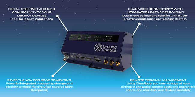
The RockREMOTE is a great solution for:
- Monitoring the performance of pressure pumps in the hydraulic fracturing process
- Capturing the data from flowback well tests
- Capturing production data
Also popular with the Oil & Gas sector
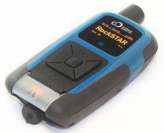
RockSTAR
Promoting better lone worker safety, the RockSTAR is a Two-Way Messenger global communication device and tracking system. Working far beyond the reach of Wi-Fi and GSM networks, companies can deliver peace of mind, with location updates, up to every 15 seconds.
RockFLEET
With the RockFLEET organisations know where their vehicles are, at all times and can visualise asset location on an easy-to-use web-based viewer. Additionally devices can be used to measure payload, optimise delivery routes and even capture early warnings of required maintenance.
Hughes 9502
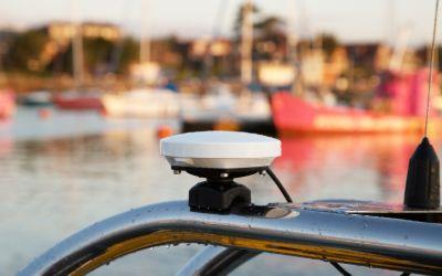
BGAN M2M-capable terminals like the Hughes 9502, are low cost – typically with billable unit costs of 1 to 2 cents per kilobyte, and low power (.01 to 4 watts). Offered in one-piece or two-piece form factors, there is also a variant compliant for operation in Hazardous environments.
Discover the value add of better connectivity
Going digital in the Oil & Gas sector is getting easier. But many companies still fall at the first hurdle – connectivity. We have supported our Oil & Gas customers’ digital projects, IIoT applications and connectivity requirements for 20 years. So, truly – we’ve got you covered.
Interested to see what value better connectivity could deliver for your operations? Contact us today to book a no obligation discovery call.
How Satellite Technology Can Help First Responders With Disaster Relief
Over the last 20 years, there has been a staggering rise in the number of extreme weather events. According to a recent report by the United Nations, between 2000 and 2019, there have been 7,348 major natural disasters worldwide. Tragically, these have led to the deaths of 1.23 million people and resulted in an astounding $2.97 trillion in global economic losses.
With natural disasters becoming more frequent and hurricane season already in progress, it’s vital First Responders look at how they can utilize technology to best aid emergency response efforts. Boasting ubiquitous coverage, satellite technology has been used to support disaster relief efforts since the 1970s.
How First Responders can leverage satellite technology
Satellite imaging and analysis has and continues to develop, delivering crucial, accurate and real-time information to teams on the ground. As an example, California National Guard have been using satellite technology since 2018, to help them fight wildfires.
Satellites equipped with sensors are able to pick up hot spots via infrared radiation detection, effectively enabling them to see heat. This helps the state’s National Guard to detect and map fires, as well as assess the damage they cause. When a blaze is detected, a heads up is sent to one of two California Department of Forestry and Fire Protection-U.S. Forest Service regional operations centers in the state. From there, analysts use the information provided to “very rapidly determine whether or not the fires are campfires or car fires or a fire that could indeed become a very dangerous wildfire” – explains California Adjutant General Maj. Gen. David Baldwin.
However, aerial imaging is not the only way satellite technology can enable a more effective, safer, emergency response. Although terrestrial networks are built to be resilient, outages due to hurricanes, earthquakes, floods and other severe weather is common. With many natural disasters rendering terrestrial infrastructure inoperable, increasingly, redundant communications are becoming an integral part of disaster relief and management.
First Responder communications
For First Responders, the importance of communication can never be underestimated. Ultimately, response disciplines must connect and work together, to ensure the best outcomes during disaster recovery and maintaining public safety more generally.
However, it was reported by the government that first responders in the US rely on more than 10,000 separate, incompatible, and often proprietary radio networks to communicate with each other during emergencies. Given the significant consequences of not being able to properly disseminate information during an emergency, this is concerning.
Critical SATCOM for First Responders
Today, satellite communications (satcom) play an essential role in the global telecommunications system. Approximately 2,000 artificial satellites orbiting Earth relay signals carrying voice, video and data to and from, one or many locations worldwide. While many may be familiar with the benefits of push-to-talk devices and satellite phones, VSAT and Go-anywhere Pro (previously known as BGAN) terminals can also be particularly effective during disaster management.
Following the mass destruction of hurricanes Irma and Maria in 2017, 900 VSAT terminals were deployed at sites around the affected region and critical locations including San Juan Airport. VSAT terminals can enable:
- Data and broadband connectivity
- Voice communications
- High throughput data
- Drone video backhaul
- Red Phone Emergency Responder Voice Network access
As such, they can prove invaluable during disaster relief. VSAT and Go-anywhere Pro terminals not only deliver rapidly deployable connectivity, enabling effective response coordination, they also deliver instant infrastructure. First Responders and recovery teams can communicate with each other and relevant control center(s), analyze the situation and make adjustments.
Connectivity also empowers teams to better support continuity throughout the recovery process. For example, enabling point of sale (POS) credit and debit card authorizations and inventory management, meaning individuals can purchase recovery essentials including food and fuel.
With over 20 years experience enabling critical safety across the globe, Ground Control has been a trusted name in Emergency Responder satcom since 2002.
VSAT and Go-anywhere Pro solutions for Emergency Responders
Toughsat Flyaway Mobile Hotspot
The Toughsat Flyaway is often used by emergency services that need a quick and portable VSAT antenna for both high-speed internet and VoIP phone services for on-site personnel.
The Toughsat Flyaway satellite system delivers Ground Control’s powerful Toughsat XP satellite solution, in an easily transportable set-up. The multi-functional stabilization brackets work for both ground mounting and roof-rack “fly-and-drive” mounting – even on rental vehicles. With an auto-pointing antenna, robust, high-speed internet and redundant communications can be quickly deployed at any location.
We’re proud to say our Toughsat solutions are trusted by hundreds of Urban Search and Rescue agencies, Federal Police, State, County and City Law Enforcement and Fire Departments throughout the United States today.
MCD-4800 “The Football”
Similarly, the MCD-4800 “Mobile Communications Device”, also known as “The Football”, is also capable of providing redundant communications and high-speed internet, anywhere in the world. The auto-pointing Go-anywhere Pro satellite terminal requires no user training to operate and can be used in extreme weather conditions.
Users simply place the weatherproof case on the ground or any surface with a clear view of the sky, turn it on and close the lid. Within a minute the MCD-4800 becomes a powerful WiFi hotspot accessible by any wireless device within a 100 meter range for up to 5 hours on internal battery power.
This auto-pointing solution uses the high performance Hughes 9450TW in-motion Go-anywhere Pro terminal integrated with our proprietary mobile electronics for a ruggedized, self-contained, user-friendly, global communications link.
Ground Control’s emergency communications satellite equipment meets or complies with all SAFECOM requirements, for emergency interoperable communication equipment.
Ultimately, satellite technology helps promote First Responder safety and efficiency, during disaster recovery. The technology has already been used worldwide to monitor events, improve responses and drive resilience post-disaster, providing infrastructure support.
If you’d like to get in touch to discuss potential satellite solutions for your organization or agency, simply email sales@groundcontrol.com.
Get in touch
With over 20 years experience facilitating emergency preparedness and response across the globe, we understand that in a crisis, every second counts. We’re constantly evolving and adapting our Public Safety offer and systems to best support teams on the ground. Which is just part of the reason Ground Control has been a trusted name in Emergency Responder satcom since 2002.
Whatever your communication or connectivity needs, we can help.
Utilizing VSAT and BGAN to Achieve Broadband Internet
When living and working in remote locations, there are limited options when it comes to internet connectivity and telecommunications. For individuals working for example, at sea, or on an oil rig, this operational challenge is likely something they are very familiar with. Thanks to advancements in technology however, there are two popular options for IP communications over satellite – VSAT and Viasat’s BGAN – now known as Go-anywhere Pro.
At Ground Control we enable individuals, businesses and organizations to operate efficiently and safely, no matter where they are based in the world. So for those not in the know, or new to facilitating operation connectivity in remote areas, we have broadly outlined how VSAT and Go-anywhere Pro (previously known as BGAN) work, and their relative strengths and weaknesses in the delivery of broadband internet.
What is VSAT?
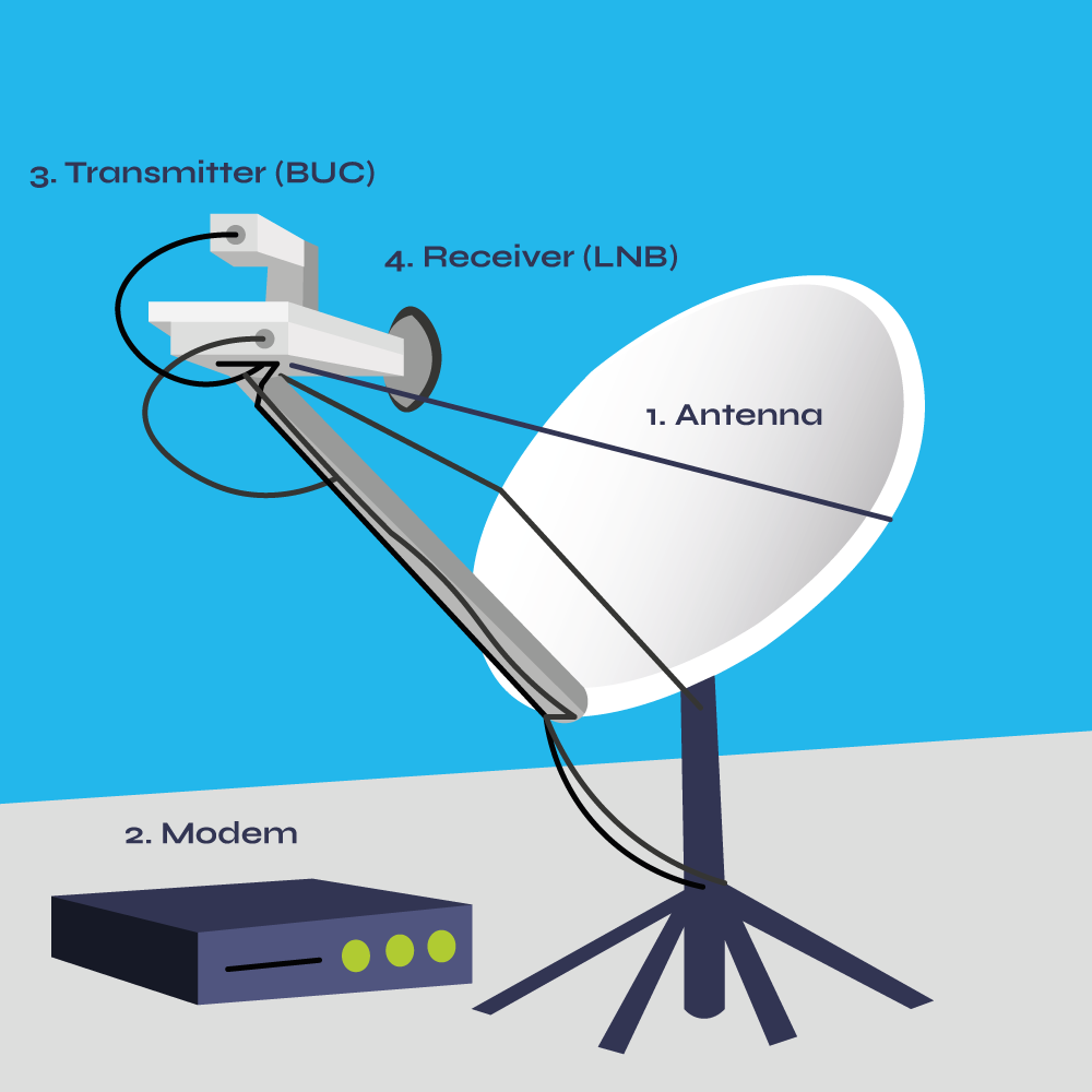
VSAT – “Very Small Aperture Terminal” – is a satellite ground station that allows businesses and individuals to transmit and receive data, voice and video via satellites. The dish antenna will always be smaller than 3.8 meters in this classification and in most cases, around 1.0 meter. VSAT systems are comprised of four main elements:
- Antenna
- Modem
- Transmitter (BUC)
- Receiver (LNB)
How does VSAT work?
The VSAT antenna dish is positioned in direct sight of the satellite. The antenna receives data from the satellite, which the receiver (LNB) collects. The receiver then converts the data into a lower frequency signal which can be transmitted over coax cable and interpreted by the modem and thus user device, for example, a laptop. Conversely, the transmitter (BUC) transforms data received via the user device and modem, back into a higher frequency (usually Ku and Ka Band), to ensure this can reach the satellite – 22,300 miles above the earth’s equator.
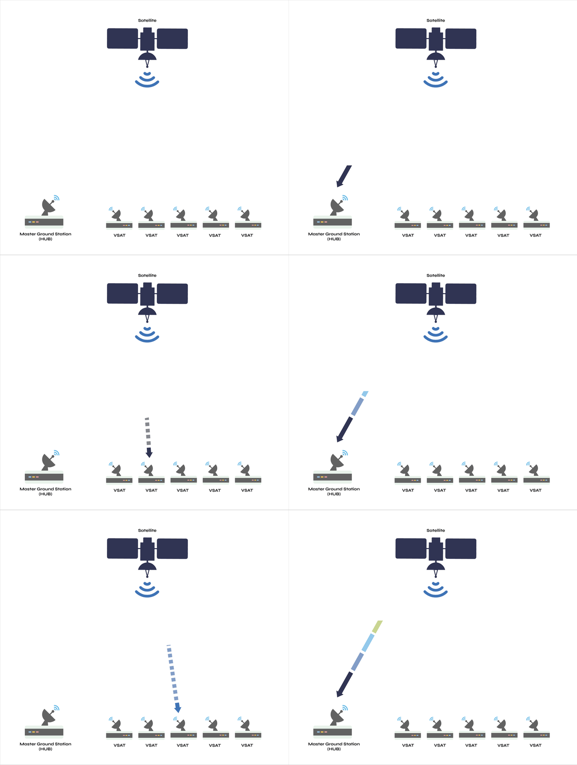
The antenna consists of small terminals which can be installed across distributed sites, and connected to a central hub via the satellite. With VSAT, data is either relayed from these terminals (also termed small remote ground stations) to other terminals (in mesh topology), or master ground station “hubs” (in star topology). In the case of the latter, the “hub” controls the entire operation of the network. For one end user to communicate with another, each transmission must first go to the hub station via the satellite link, the hub station then retransmits this via the satellite to the other end user’s VSAT. This tends to be implemented in situations where there is a Head office – Branch office type hierarchy, and is able to accommodate a large number of terminals.
VSAT Star topology
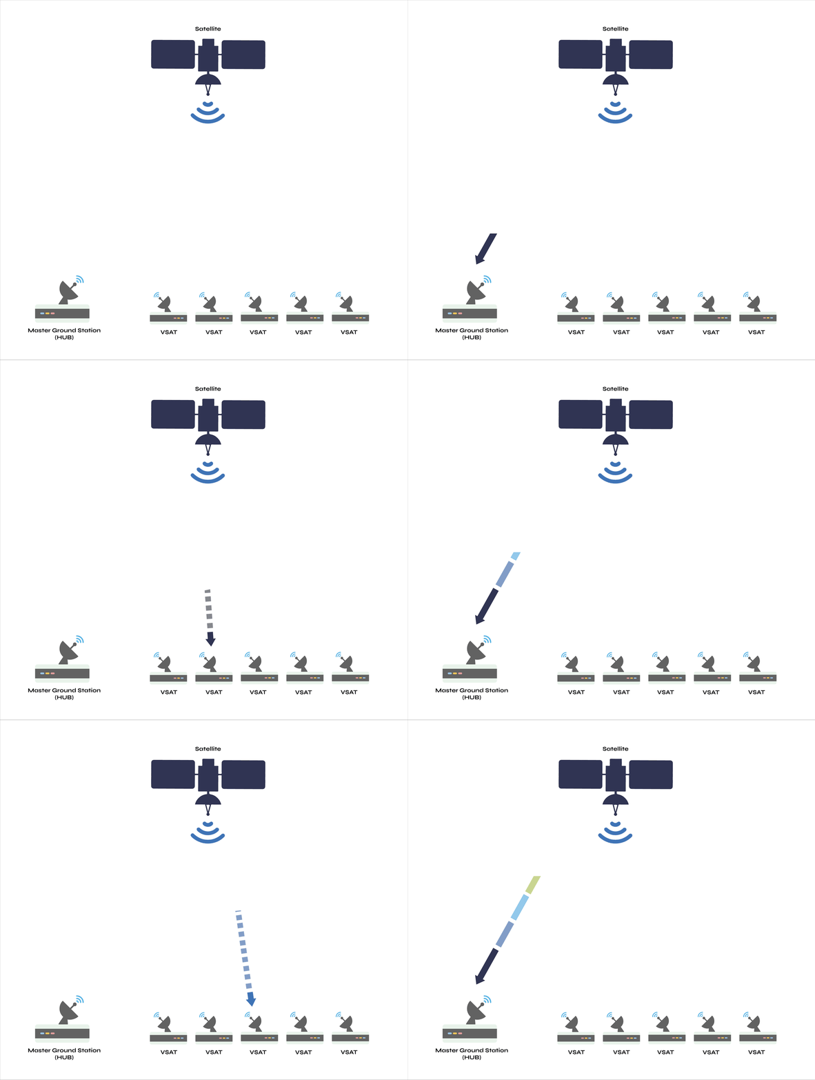
In contrast, with a mesh topology, all terminals can communicate with each other via the satellite without going through a central hub. This set up normally supports 5 – 30 terminals.
VSAT Mesh topology
What is Go-anywhere Pro?
Go-anywhere Pro – (previously known as BGAN – “Broadband Global Area Network”) – is a satellite network which consists of four satellites owned by Viasat. The network can deliver high-speed voice and data connectivity via BGAN terminals, which are often both compact (size of a laptop) and portable.
Viasat licenses several manufacturers to develop Go-anywhere Pro terminals that communicate with the orbiting Inmarsat satellites. Ground Control offers all available Viasat terminals, including one we manufacture called the MCD-4800 – “The Football”.
How do Go-anywhere Pro terminals work?
The Go-anywhere Pro terminal is placed within a clear view of the sky, from there the terminal obtains its position using GPS. The terminal then needs a line-of-sight to one of the satellites within the network. This means there cannot be any tree, wall or building between the terminal and satellite. Usually units are set up outside, but they can be inside, if the satellite can be seen through a window. To achieve alignment, some terminals are turned slowly by hand, until they indicate that they have found the satellite – manual pointing. Or in the case of the MCD-4800, the unit automatically aligns with the satellite – auto-pointing. Finally, often just with the touch of a button, the terminal auto-negotiates with the satellite and connects.
Computers and other devices are then connected to the Go-anywhere Pro terminal, either through a simple ethernet cable, or via Wi-Fi.
VSAT vs Go-anywhere Pro
Broadly speaking, the differences between VSAT and Go-anywhere Pro can be grouped into the following categories: Coverage, Reliability, Cost and Security.
Coverage
The Viasat Go-anywhere Pro satellite constellation provides a seamless network that operates with near global coverage. VSAT coverage is similar, but in most cases it is not seamless as users will often require separate contracts on different satellites and teleports.
Additionally, if coverage is required while physically moving, it’s important to note the distinction between mobile and on-the-move connectivity. Some VSATs are considered mobile, insofar as they can be packed into, or attached on top of a vehicle to be set up in different locations. But VSATs with phased arrays or electronically steered antennas such as the Kymeta u8 GEO, can deliver on-the-move connectivity. Likewise, select BGAN terminals like the MCD-4800, support connectivity on-the-move via auto-tracking.
Furthermore, location, or more specifically likely weather in said location, can also be a very important coverage factor. VSAT satellite technology operates in a number of different frequencies, including C band (4 and 6 GHz), Ku band (12 and 14 GHz) and Ka band (20 and 31 GHz). Although Ka band enables users to send more information per second, this higher frequency is also the most impacted by weather conditions, for example heavy cloud, rain and snow. This phenomenon known as “rain fade”, also affects Ku band, albeit to a lesser extent. Conversely, the L band (1 to 2.7 GHz), used by Go-anywhere Pro terminals, can deliver a stable connection, even in adverse weather conditions.
Reliability
There are multiple satellites with coverage of most areas of the world, creating built-in options to reroute traffic for continual service even when there is a satellite failure. This makes both VSAT and Go-Anywhere Pro very reliable, with availability rates of 99.5% and above. However, reliability during use is arguably dependent on two important factors:
- Number of concurrent users: The number of simultaneous users will impact the connection. Due to available bandwidth, generally Go-anywhere Pro is used for individual users or small teams with basic needs. Whereas VSAT is able to accommodate large operations, with dozens of users and a wider base of applications.
- Connection speed: Go-anywhere Pro is capable of achieving standard IP data speeds of up to 492 kbps and streaming speeds from 32bps to 650 kbps (Go-anywhere Pro Streaming HDR). However VSAT bandwidth can be selected from 64 Kbps to multiple Megabits per second. Meaning users can send and receive large quantities of data much faster with VSAT.
Cost
Initial cost – set up
Go-anywhere Pro terminals series from $1,295 to $13,495 for units with auto-pointing – simply, a device capable of aligning itself with an appropriate satellite. For Go-anywhere Pro terminals that provide on-the-move connectivity via auto-tracking, units are priced upwards of $13,495. As installation for Go-anywhere Pro terminals is relatively simple, often users are fine without assistance from a technician.
Similarly, VSAT costs vary significantly, depending on multiple factors including the bandwidth the equipment uses and size of hardware. Entry level setups start around 3,000 but can be $10,000+ for large scale operations. For these, organizations must also factor in costs for mounting solutions and installation. In contrast to satellite TV, in which antenna dishes only need to receive data, VSAT antenna dishes need to be placed within one tenth of a degree to ensure data can also be sent to the satellite in the sky. So a trained technician is required for installation.
VSAT systems with auto-pointing are priced from $20,000, but due to the automation, these units often don’t require trained manpower for installation.
Operating costs – Service plans
VSAT airtime plans usually have a fixed monthly rate, which is based on the bandwidth speed – ranging from $200 to $20,000/month. Some VSAT bandwidth plans enable users to pick their desired upload and download speeds, while more Enterprise Level VSAT networks have a monthly metered service – enabling network operators to build a higher quality network.
Go-anywhere Pro’s Standard IP service is charged per Megabyte (MB) of data received and/or transferred, which ranges from $3 to $7 per MB. Generally speaking, when moving large amounts of data, VSAT is a more cost-effective solution long term. However, new variations in Go-anywhere Pro pricing plans have allowed high data users to reduce the price per MB to near VSAT prices, at high volumes. We recommend speaking to a satellite professional who will be able to take your application needs and projected daily, monthly and annual usage into account, to help you identify the most cost-effective package.
Licenses
In addition to service plans, depending on the operation location(s), users may be required to obtain appropriate licensing. Africa, Latin America and Asia, all have stricter regulations regarding licensing – so authorisation may be required. Licensing varies from country to country for both Go-anywhere Pro and VSAT, however Go-anywhere Pro licensing is usually less expensive than VSAT. Organizations should analyse their case with an expert, so they know what to expect in the different countries they plan to operate within.
Security
VSAT and Go-anywhere Pro networks are standards based and support IP (Internet Protocol) and its variants through a protocol called IPoS (Internet Protocol over Satellite – TIA 1008). Both also support encryption of all data transmitted between two sites or multiple sites, which make the creation of Virtual Private Networks (VPN) possible. This capability enables users to achieve a far greater level of security.
In summary, there are clear advantages to both Go-anywhere Pro and VSAT technology. VSAT is best for permanent installations that need ample bandwidth, for example, delivering broadband to multiple users, at the same time, in off-grid areas. Go-anywhere Pro is better suited to single users or small teams with sporadic usage patterns, and mobile use, for example, vehicles on land and at sea. However, this article is for the purposes of broad understanding only. There are a lot of factors at play, and we advise anyone setting up a remote operation which requires connectivity, to get in touch with our experienced team.
Want to deliver reliable connectivity to your off-grid operations?
There are a lot of components to consider when deciding on the best solution for remote, reliable, connectivity. With over 20 years experience, our expert team is on hand to help guide you through this process. And as a preferred Iridium and Viasat partner we can also help you maintain connectivity, while reducing your daily, annual and ongoing costs.
Can We Help?
With 20 years of experience, we can help you make the best choices for your critical communication infrastructure.
We’re not invested in selling you a specific product or connections, just the best solution for your needs. Complete the form, email hello@groundcontrol.com, or call us: Europe, Asia, Africa and Oceania: +44 (0) 1452 751940 | North and South America: USA: 800 773 7168
Selecting the Right Satellite Connectivity for the Oil & Gas Industry
For Oil and Gas companies, selecting the right satellite connectivity to connect people or machines can be complex. We’ve built a simple decision tree to help you determine the best satellite solutions to connect people or machines, whether your throughput requirements are low or high, fixed or mobile.
*Mobile can also be fixed
These products are of course not your only options for these requirements, but they are our top picks, and here’s why.
Iridium Extreme 9575 PTT
The Extreme 9575 PTT is Iridium’s top-of-the-line push-to-talk satellite phone. It offers superior PTT, voice, SMS texting, GPS, low-speed Internet, SOS button, and real-time web-tracking. This ruggedized satellite phone works in all weather conditions and is an ideal communications tool for remote Oil and Gas sites, and for total connectivity wherever engineers travel.
Toughsat XP
Toughsat XP is Ground Control’s flagship professional series mobile satellite system, incorporating a powerful feature set that operates both normal and extreme remote site environments. The quick one-button deployment provides high-speed WiFi for up to 256 devices from any well site in less than 3.5 minutes.
MCD-4800
The MCD-4800 (“The Football”) is an auto-pointing Viasat satellite terminal that requires no user training to operate. Simply place the weatherproof case anywhere on site, turn it on and then close the lid – no pointing necessary. Within a minute the MCD-4800 becomes a powerful WiFi hotspot accessible by any wireless device within a 100-meter range for up to 5 hours on internal battery power.
RockBLOCK 9602
Perfect for M2M / IoT low throughput well site requirements, the RockBLOCK 9602 satellite modem utilizes the power of the Iridium® Satellite Network. The versatile and reliable RockBLOCK delivers plug-and-play satellite connectivity, from any point on Earth including the polar regions.
Hughes 9502
The 9502 terminal delivers affordable, global, end-to-end IP data connectivity and is an ideal choice for Oil and Gas companies. The exceptional low power consumption (1W idle) of the Hughes 9502 makes it possible to provide end-to-end IP connectivity to sites that are off-grid. This breakthrough provides end-to-end IP connectivity to any power-challenged Oil and Gas locations that involve sensitive power budgets.
RockREMOTE
RockREMOTE delivers a reliable and flexible, all IP-based, dual-mode LTE-Satellite communications solution for fixed, semi-fixed or mobile M2M / IoT applications worldwide. Customers select between Ethernet, Wi-Fi or Serial RS232/485 for their communications interface requirements. The solution combines the RockREMOTE terminal, the Iridium Certus network and LTE cellular connectivity, end-to-end networking and the powerful Cloudloop platform. It can be tailored to address a variety of fixed and mobile communications challenges faced by Oil and Gas engineers.
SCADASat
The SCADASat by TSAT satellite system is designed to meet the demanding requirements of the Oil & Gas industry. SCADASat provides a private satellite network operating a direct communication channel between a process control centre and these often remote locations. By locating a private TSAT3000 HUB at a control centre, complete independence of any public infrastructure is obtained, and secure and reliable communication between Oil and Gas sites is assured.
Can We Help You?
With 20 years of experience, we can help you make the best choices for your remote connectivity, whether you need one or several thousand devices!
We’re not invested in selling you a specific product or connections, just the best solution for your needs.
Call us on +44 (0) 1452 751940 (Europe, Asia, Africa, Oceania) or 800 773 7168 (North and South America), complete the form, or email hello@groundcontrol.com.
Comparing the Cost of BGAN Satellite Connectivity with Field Engineers
Nobody questions the value of data extracted from oil well sites. From exploration to flowback testing, and drilling to recovery, there is both routine and failure data to be captured, stored, shared and analyzed.
In many cases, this data is out of reach of terrestrial communication networks, giving production companies two choices: send someone to retrieve the data, or set up a satellite communications network.
In this blog post we’re comparing the pros and cons of both options. Full disclosure: we believe satellite connectivity is the more scalable, cost-effective and safe approach, but we’ll be as objective as a satellite communications company can be!
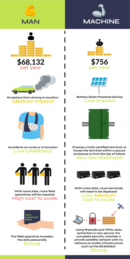
Field Engineer vs. BGAN machine
Here’s a full breakdown of the relative costs of operation
An experienced Field Engineer costs on average $68,132 per year. Plus expenses and other benefits including company vehicles and overtime charge out rates.
The cost of operating a BGAN satellite connectivity terminal can be as little as $63 per month for up to 20MB – a saving of $68,069 annually and $680,690 over the typical 10 years lifetime of a BGAN terminal.
Gas is an ever-increasing expense and the cost of fuel has increased around the world. The average Field Engineer will travel on average 25,000 miles per year. With the average gas price currently $3.34, this amounts to almost $3,500 in fuel costs alone; with insurance and taxable miles on top, and of course chargeable time.
Time is money. Onsite maintenance of traditional connectivity devices can take several hours to service – with on-site visits taking place on average once per week. Even then, there is no guarantee of the issues being resolved without further callbacks. Installation of a BGAN device mitigates the need for on-site Engineers. With a reliable uptime of 99.9%, BGAN requires minimal servicing, maintenance or ongoing equipment checks.
A single weekly call-out based on the average Field Engineer’s salary is a day rate of $272.52. With expenses, it is likely to be around $500, each time the system fails and on the basis that the fault can be rectified the same day. BGAN is highly reliable – even when installed in the most remote locations. Installation of one BGAN satellite connectivity device across the oil well network of ten pumps could save tens of thousands of dollars each year.
Servicing, ongoing maintenance and fault checking is costly work. In addition, equipment required to measure and transmit data from oil well sites often costs hundreds, if not thousands, of dollars per month. Installation of a BGAN satellite connectivity device mitigates these costs completely. Reporting on exception, the costs to transmit and measure data are as little as $2 a day.
BGAN satellite connectivity devices are incredibly cost-efficient. The typical hardware and airtime requirements for a remote oil site are just $2 a day, or $756 per year. Compared with the average cost of a Field Engineer, the savings to your business are in excess of $67,376 every, single, year.
Want to know how you can reduce your call out costs?
We’re a preferred Iridium and Inmarsat partner and can help you to reduce your daily, annual and ongoing connectivity costs. It’s what we do best and we’re always here to help. Email us on hello@groundcontrol.com or call:
UK and RoW +44 (0) 1452 751940
USA +1.805.783.4600