Topic: Iridium
Satellite-Enabled LPWAN: What Network To Choose, When, and Why
LPWAN – Low Power Wide Area Networks – enable users to connect sensors / endpoints over large distances. They’re lower cost and consume less power than cellular, and while their data capacity rates are lower, there’s enough bandwidth for most IoT applications.
This article focuses on satellite-enabled LPWAN. Satellite comes into the equation when the sensors you’re connecting are so remote there’s no cellular infrastructure at all. At the moment, that leaves you with two options:
- Use an unlicensed LPWAN technology such as LoRaWAN, mioty or Sigfox to connect your sensors, then backhaul the aggregated gateway data via a satellite transceiver;
- Or, connect your sensors individually to a satellite transceiver.
The Differences Between Licensed and Unlicensed LPWAN
Before we settle into the main topic, some readers may find a quick explanation of licensed / unlicensed LPWAN helpful. The former leverages licensed radio frequency spectrum, which means connections use dedicated frequencies, making them more reliable. They also offer higher data capacity rates than unlicensed spectrum. Currently the best known networks – NB-IoT, LTE-M – rely on cellular infrastructure. Because of this dependency, they’re not used for extremely remote applications.
However, satellite LPWAN also falls into this category – services like Iridium’s Short Burst Data (SBD) and Certus 100, and Viasat’s IoT Nano and Iot Pro, all leverage licensed spectrum. Satellite LPWAN has no dependency on terrestrial infrastructure, so is usually deployed where there isn’t any – i.e. outside of population centers.
Unlicensed networks share frequencies with all other unlicensed users, so reliability in high-traffic areas may be an issue. They also have capacity issues because of the frequency spectrum they operate in – which is only suitable for very small amounts of data (LoRa has a maximum data rate of 50 Kbps). However, unlicensed LPWAN is lower cost, and devices generally require a little less power than networks operating in a licensed spectrum, although both perform well. For example, NB-IoT devices will typically operate for up to 10 years, and LoRa devices for up to 15 years, using battery power.
LoRa is the most widely adopted and well known unlicensed LPWAN, but there are many more here, including SigFox, Helium, RPMA and mioty. In the case of LoRaWAN, there are commercially operated networks that you can buy into, or you can set up your own private network.
If you’re in an area with cellular infrastructure, you can weigh up the pros and cons of licensed and unlicensed networks, and choose the solution best suited to your needs from a long list of options. In a remote area without cellular, you’re back to the choice we posed at the beginning: connecting individual sensors via licensed satellite LPWAN, or using an unlicensed LPWAN to aggregate many endpoints, which has no dependency on cellular infrastructure.
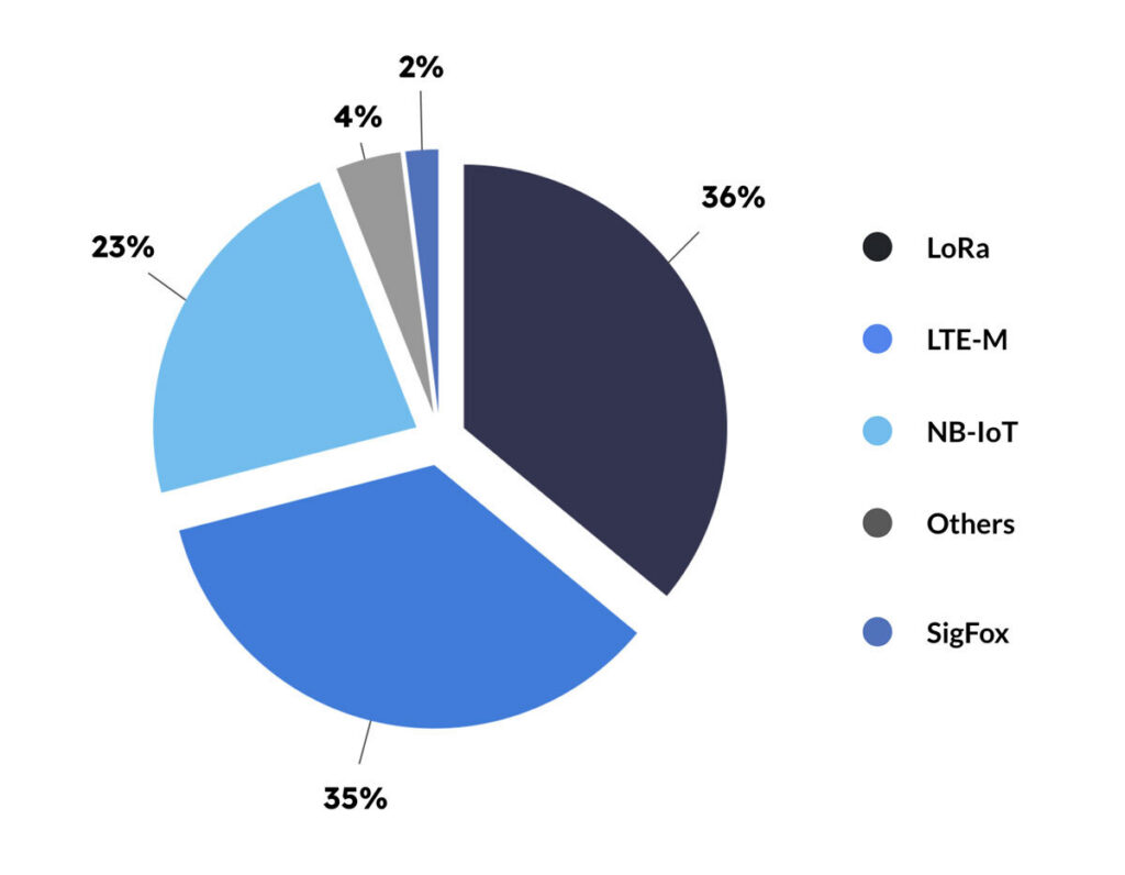
In terms of projected market share, China’s state-wide adoption of NB-IoT makes it the global leader; remove China, however, and the competing technologies are more evenly distributed (data from IoT Analytics). In this chart, which looks ahead to 2027, LoRa is the leader with 36% market share, followed by LTE-M at 35%, and NB-IoT at 23%. LoRa is on the way down from its peak, however, and NB-IoT shows the strongest growth.
How Unlicensed LPWAN Works with Satellite
While there are many options for unlicensed LPWANs, because of its dominance, we’re focusing on LoRa.
LoRa networks require a gateway, or several gateways, depending on the size of the network, where the sensor data is aggregated. If the gateway is within cellular coverage, cellular can be used for data backhaul, but in remote applications, satellite is the best option for backhauling the aggregated sensor data. Co-locating your gateway(s) with a satellite transceiver like RockREMOTE ensures you can communicate with your sensors from anywhere on the planet, as long as you have a clear view of the sky.
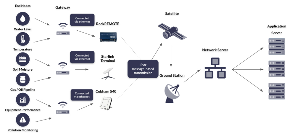
NB: LoRa is a communication technology. LoRaWAN is a media access control (MAC) layer protocol which makes it easier and more secure to manage communication between gateways and endpoint devices (read a better explanation). So while LoRa can be, and is, used without the MAC layer, in the context of a wide area network, LoRaWAN is far more likely to be utilized.
LoRaWAN:
- Has a maximum data rate of 50 Kbps
- Works better for stationary applications
- Works best in open, flat areas such as farmland
- Is license free, therefore low cost
- Drains very little power – battery life can be up to 15 years
- Has strong security measures, with built-in end-to-end AES-128 encryption
- Can be built independently of terrestrial networks and commercial providers
- Works well when gateways are co-located with a satellite IoT transceiver
- Is tried, tested, and in use today for remote IoT applications.
When to use Individually Connected Devices
The main advantage of LoRaWAN is that it’s very low cost, but that cost increases if you’re using a commercially operated LoRaWAN. If you don’t, you’ll need to build the network yourself, which involves purchasing gateways and a network server, writing firmware, and creating the connections (read how to build a private LoRa network).
This could well be worth the effort, but it depends on the number of sensors you’re connecting, and their location. LoRaWAN is a ‘single-hop’ technology; each connected sensor communicates directly with the gateway or hub. If there’s a long distance between device and hub, or there are geographical features like mountains or forests, this can impede the signal. So, there are instances where individually connecting sensors to a satellite modem is faster, more reliable, quite possibly cheaper when time and expertise is factored in, and more efficient.
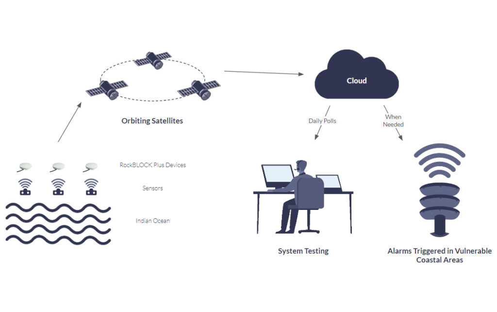
For example, American Signal Corporation has hundreds of tsunami warning stations positioned off the coast of Thailand, to prevent a repeat of the Boxing Day Tsunami that claimed hundreds of thousands of lives.
These stations are located in the ocean, far from cellular infrastructure and mains power, and need to be both completely reliable and able to transmit their data in as close to real-time as possible. The latency and reliability issues of LoRaWAN make it unsuited to this application – as does the fact that some of the sensors are positioned well over 10 km apart.
Instead, each station has its own satellite transceiver – the RockBLOCK Plus – which uses the Iridium Short Burst Data airtime service. This checks all the boxes: it’s a low cost, low power, reliable, low latency means of transmitting data from anywhere on Earth with a clear view of the sky.
This solution is being used in many scenarios like this where the data must get through, and there’s no cellular infrastructure, and building a LoRa network (or similar) would be cost and/or time-prohibitive.
Satellite LPWAN:
- Works well in both mobile and stationary applications
- Has no limitation on the distance between your sensors – they can be positioned as far apart as your application requires
- Has a huge amount of flexibility in terms of data rates – up to 464 Kbps (although the lowest power consumption comes from the message-based services of Iridium Short Burst Data, and Viasat IoT Nano)
- Can operate on a solar powered battery for 10 years (depending on data rates and frequency of transmission)
- Is secure by design – it’s very hard to intercept the data while it’s in space, and firewalls, VPNs and private lines protect the data once it’s earth-bound again
- Has no dependency on terrestrial infrastructure
- Will work in any location, including mountains and forests, as long as there is a clear view of the sky
- Is not affected by extremes of temperature or adverse weather conditions.
Coming Soon: NTN NB-IoT
This is developing technology, with the goal of offering a single SIM to work on multiple cellular and satellite networks.
While the technology exists today to seamlessly switch between cellular and satellite networks, the devices enabled with this technology are using proprietary modems that only communicate with a single satellite network. Relatively few are produced, and they’re more expensive than their cellular-only counterparts. Moreover you’re tied into that satellite network, and if you wanted to use an alternative satellite network, you would need to buy a completely different device.
3GPP standardization is poised to disrupt this model. Firstly, there are many more cellular IoT-connected devices than there are satellite IoT-connected devices, and so production of these dual-function modems would benefit from economies of scale. They are likely to be lower cost than today’s proprietary satellite IoT modems.
The other potential benefit will be the ability to switch between satellite network operators in much the same way as you can switch between cellular networks today. Every satellite network that is 3GPP compatible with coverage in your area should be able to offer you service. It’s by no means certain, but we think this is likely to increase competition and lower pricing.
So, the impact will be to make NTN NB-IoT not just possible but also cost-competitive over the long term. That said, it will still be a more expensive solution than an unlicensed LPWAN – and for good reason, as it retains the higher data capacity rates and reliability benefits of licensed spectrum.
The lower cost modules may well move the tipping point between individually connected endpoints / sensors vs. building a LoRa network. Individually connected endpoints, as we’ve already discussed, have the benefit of being easy to set up, reliable and low latency. The number and location of the endpoints determine the choice of network today, and that will be true with NTN NB-IoT, too. But as the cost will be lower, the point at which it makes sense to use LoRa (or similar) will, we anticipate, come at a higher number of endpoints than it does today.
It may also open up new use cases for geographically dispersed endpoints that could utilize satellite IoT today, but the proprietary modems make this cost-prohibitive. Applications in Agriculture, Utilities, Mining and Oil & Gas are likely to emerge as the device and airtime costs decrease.
NTN NB-IoT:
- Has a maximum data rate of 159 Kbps up, 106 Kbps down
- Works well for stationary and slower-moving mobile applications
- Offers greater reliability as the network is more exclusive
- Strong support for user identity confidentiality, authentication and integrity
- Doesn’t require a gateway, but you will need – once available – a dual mode satellite and cellular SIM card in each device
- Will no longer need terrestrial cellular infrastructure once Satellite Network Operators (SNOs) make their satellites compatible with the 3GPP standard
- Should support route switching in the future, keeping costs low and predictable.
What is 3GPP?
3GPP is a global initiative to basically stop telecommunication infrastructure developers from all doing their own thing. Since 1998, they’ve successfully driven standardization across cellular development. Release 17, in 2021, included satellite connectivity to the technology mix for NB-IoT delivery – often referred to as NTN (non-terrestrial network).
If an orbiting satellite network meets the 3GPP standard, someone, or something, on Earth that has a similarly 3GPP-compliant modem in their device could pass out of cell tower range, and immediately switch to satellite, with no interruption of service, and no need for separate hardware. All the excitement about direct-to-device technology stems from this, but “Rel-17” also unlocks NB-IoT’s use in extremely remote locations, with satellites performing the task of cell towers.
What About Non-Terrestrial LTE-M?
LTE-M is, like NB-IoT, a licensed LPWAN designed to operate on cellular networks. It’s a little more expensive because it offers higher bandwidth transmissions, and supports roaming: it was designed to work for mobile and fixed IoT applications, vs. NB-IoT that is best used in fixed IoT applications. Both are part of the broader 3GPP standard, and so the structure exists to use satellites to perform the role of cell towers in space.
At the time of writing, the satellite network operators moving the fastest towards NTN architecture are using NB-IoT as their preferred technology. However, Starlink will use a form of LTE when it brings an IoT proposition to market, and other satellite network operators may well follow suit.
What’s Best for Your Remote Application?
There is a lot of hype around 3GPP standards-based technology, and when it comes to fruition, users will benefit from lower cost modems and possibly, because of increased competition, lower cost and more predictable airtime bills. Many major satellite network operators – Iridium, Inmarsat, Viasat, Starlink – have announced plans to support a form of this technology (either NTN NB-IoT or LTE) in the future.
There are companies already offering this service, but at the time of writing, they have patchy coverage, and data capacity rates are very low. The full value of this technology will be realized when there is global availability and multiple service providers – which is currently looking like 2026-27.
If you’re building your remote application right now, your choice of LPWAN depends on your application. If your devices are very widespread, LoRaWAN may not be your best choice given the higher risk of packet loss between the sensors and the gateway(s). It is cost-effective, particularly when paired with a satellite transceiver like RockREMOTE which supports edge computing, thus allowing you to optimize your transmissions. If you can manage with a degree of data delivery uncertainty (due to the capacity challenges in the unlicensed radio frequency spectrum), it’s a good choice.
For devices spread over a wide geographical area, connecting each sensor or sensor array to a satellite IoT transceiver ensures that you will receive your data, with no dependencies on terrestrial infrastructure, and no reliability issues due to contested spectrum. If you choose a service like Iridium Short Burst Data, or Viasat IoT Nano, you’ll receive your data in close to real-time, too. Connecting sensors in this way costs more, but even now is less expensive than people imagine. For mission-critical applications, it’s the most reliable, fast and secure means of capturing your widespread remote sensor data.
Can we help you with your remote application?
If you’re connecting endpoints in remote locations, we hope you’ve found this article useful. We are experts in satellite connectivity, and work with multiple satellite network operators to ensure our customers get the best combination of coverage, reliability, price and latency.
If you’d like to speak to one of our team, please complete the form, or email hello@groundcontrol.com. We’ll come back to you within one working day.
A Guide to Satellite IoT for Cellular IoT Specialists
This article aims to help cellular IoT specialists integrate satellite IoT into your infrastructure. Many of the challenges you face in cellular connectivity – interoperability, coverage, power consumption, data optimization, etc. – have parallels in satellite connectivity. If you know what to expect, you can plan accordingly, and save yourself time and money in the long run.
Consideration #1: Data Optimization
“Just because it’s a free lunch doesn’t mean you should eat as much as you can” – Robby Hamblet, TEAL
So, you’ve connected 90% of your sites with cellular, but the final 10% are out of cellular coverage, and satellite is your only option. In this common scenario, the first challenge is the volume of data you’re expecting to push through a satellite connection. As more and more IoT devices use up more and more bandwidth, even in cellular IoT, developers are being encouraged to be more circumspect with how much bandwidth they really need.
This is an acutely important consideration in satellite IoT. Satellite Network Operators (SNOs) have a limited amount of licensed spectrum, and satellite “masts” are really far away (as much as 35,786km). SNOs consequently charge a relatively high premium. This is coming down, but it’s not realistic to expect parity with cellular given that operating costs are high, and capacity is limited.
Cost, therefore, is a major incentive for systems integrators and developers to start thinking about how you can reduce the amount of data you send over satellite. The other incentive is power consumption: sending a lot of data tends to mean larger antennae which can’t operate without mains power. And as we’re talking exclusively about IoT here, we’re assuming the 10% of sites you’re unable to connect with cellular are also fairly unlikely to have mains power too.
The most practical solution? Edge computing. There are lots of ways in which you can utilize some intelligence at the edge to restrict how much data you send over satellite. You can reduce the frequency of your transmissions, batching them to make better use of an IP connection. You can report by exception. You can define and tag your data priority, thus allowing certain types of data to pass through more frequently than other, less critical, types of data.
If your devices can control your data in this way, perfect. If not, sophisticated satellite terminals like the RockREMOTE have flexible edge computing capabilities that will allow you to create rules to limit your transmissions there.
Real World Example
A renewable energy company we work with has a sensor array to detect wind turbine interactions with birds and bats. The gateway for the sensors expects to be able to pump data out continuously as long as there’s an open connection: potentially fine if you have a cellular connection, but expensive and inefficient if you are using satellite. Our solution was to add a timed firewall to the connected satellite transceiver. For one hour a day, the firewall is dropped, and the gateway sends its aggregated data in batches. Simple and effective.
Consideration #2: Interoperability
You may have had to navigate situations where there have been multiple communication protocols (WiFi, Bluetooth, Zigbee etc.) to contend with, particularly in legacy infrastructure. If so, you’ll already appreciate the benefit of planning ahead and considering the future development of your network. If it’s at all possible satellite IoT will factor in, knowing the application protocols in most common use will help.
There are basically three options for IoT communication over satellite:
1. Use an IP service like Iridium Certus 100 or Viasat IoT Pro
This plug-and-play option is the easiest means of sending data over satellite, but not the most efficient or cost-effective way. However, there’s plenty you can do to optimize your data (see above) to make it work better for you if you’re not in a position to change your application.
2. Use a distributed MQTT broker solution
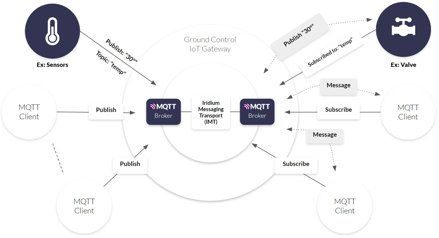
If you’re using MQTT, you’re in luck: Ground Control’s IoT Gateway effectively places an MQTT broker at either side of a satellite transmission, re-formatting the data and managing the connection, message queuing, retries etc. automatically. We use Iridium Messaging Transport to move your data, which is message-based. You can read more about this in our previous blog post, but suffice to say, messaging is the most cost-effective way to transmit data over satellite, and this is an easy way to leverage those efficiencies.
3. Re-engineer your solution to use messaging
This low-level integration will allow you to use one of the proprietary messaging services offered by SNOs such as Iridium Short Burst Data, or Viasat IoT Nano, both extremely cost-effective means of sending data via satellite. However it does usually require development work to make your data compatible with a messaging service.
Real World Example:
Most developers want an easy life (nothing wrong with that!) and will choose the path of least resistance. So it’s our job to make sure that you can use satellite IoT connectivity no matter what protocol you’re using. In one instance, a customer was unable to change their in-field sensor equipment or their server, but they did need to change the means by which data was transported between the two. We added some programming to our RockREMOTE device to effectively imitate the older equipment it was replacing, so the sensors could ‘talk’ to it with no adaptation required by the customer. And at the server end, our IoT platform Cloudloop enabled us to reformat the data and transmit it to the legacy server in the same vein.
Consideration #3: Coverage
Lack of cellular coverage is most likely what brought you to satellite in the first place, but not all satellite network constellations are created equal. Firstly, you need to ensure that the satellite network(s) you’re considering have orbiting satellites that can ‘see’ your devices’ location. Only one satellite IoT network – Iridium – is truly global, although others, including Viasat, come close.
Then you need to consider satellite density and architecture. Newer satellite networks may have just one or two satellites in orbit, which means you’ll get your data very slowly. On the plus side, they charge relatively little for airtime. Like many things, you get what you pay for: pay little, and you’ll get data once or twice a day with no delivery guarantees. Pay more, and you’ll get virtually real-time data from a network heavyweight trusted by the military and critical national infrastructure. It’s over to you to decide the frequency and criticality of your data transmissions.
Further, you need to look at the precise location of the asset / application you’re extracting data from. If it’s surrounded by trees, mountains, buildings etc. then there’s a good chance it will have difficulty ‘seeing’ the satellite. Our engineering team put a quick guide together on this topic that’ll help you avoid making an expensive mistake.
Real World Example:
A water utility customer has sensors set up to monitor its remote facilities for unauthorized entry – manhole covers, containers and buildings, principally. The individual sensors are LoRaWAN networked, and deliver their data to a single gateway. The gateway is positioned next to our satellite transceiver, and both are carefully located so that the satellite IoT device has a clear view of the sky, and can transmit the aggregated and optimized data from the gateway. We’ve used the same set up for safety systems on a boat; locally networked sensors talking to a gateway co-located with a satellite transceiver. UHF radio also works well for this purpose.
Consideration #4: Power Consumption
If your device is so far removed from civilization that there’s no cellular coverage, there’s a reasonable chance that there’s a limited power supply, too. Larger VSAT dishes like the types required to provide Starlink and OneWeb broadband internet services need mains or generator power to operate; but satellite IoT-specific terminals can be, and often are, battery powered.
You can preserve battery power in a number of ways we’ve already touched on: sending data less frequently. Sending less data, period. Using a message-based connection instead of an IP-based connection. Making sure your antenna has a clear view of the satellite network so no power is wasted in failed connection efforts.
These aren’t all exclusively satellite-IoT considerations either; if your device application disregards the characteristics for which LPWA networks were designed, you’ll drain batteries faster, congest networks unnecessarily, and degrade the service quality. If you assume data constraints from the outset, it’ll benefit your application across all communication technologies.
Real World Example:
We have a customer measuring water levels in fracking sites in northern Canada, where temperatures drop to -32C. They needed two ‘heartbeat’ messages per day with status and location, plus an immediate alert if the level switch activated.
As the sites are unmanned and unpowered, the solution needed to be self-powered, extremely robust and reliable.
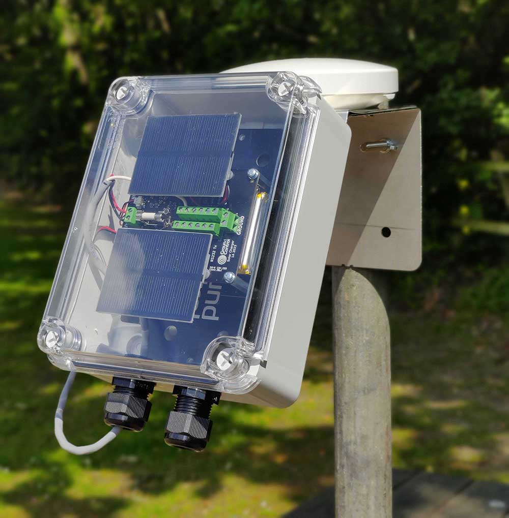
We took our RockBLOCK RTU and physically connected it to both a small solar panel array, and the sensor gateway (given how infrequently the locations were visited, Bluetooth LE as a wireless connection held too great a risk of communication failure).
The device can be remotely managed using Cloudloop Device Manager, Ground Control’s online platform to allow for OTA updates and troubleshooting.
Key Takeaway
The biggest challenge cellular IoT specialists face when implementing satellite IoT connectivity is learning to throttle back on data requirements. It’s too expensive and too power hungry to try to use satellites in the same way as you would a terrestrial network.
There are always ways we can solve this problem for customers, and we’ve discussed many of them in this post, but it wouldn’t hurt to consider data constraints from the earliest part of your planning. Even the cellular spectrum has limits, and scarcity drives innovation. Build this into your thinking and you’ll have far fewer challenges to contend with if you need to expand your network in the future.
Can we help you?
If you have a remote connectivity challenge, we can almost certainly help.
Call or email us at hello@groundcontrol.com, or complete the form, and one of our team will contact you within one working day.
We design and build our own satellite IoT hardware and IoT platform, and we’ll offer you expert, objective advice.
IP vs Messaging for Satellite IoT Data Transmission
Sending data over satellite is more expensive than sending it over terrestrial networks. It’s become less expensive – the gap has shrunk, and continues to do so – but we won’t see complete parity of service and price soon – if ever.
So, when you’re capturing data from remote assets, the first consideration is how much data you need to send. We often come across companies used to using cellular, for example, and having very few constraints on their data transmissions. That mindset needs a little adjustment for satellite transmissions.
It’s a worthwhile exercise to dig into the art of the possible here: do you have some edge processing capabilities that would allow you to report by exception, for example? Time spent up front minimizing your data will pay back in far lower ongoing airtime fees.
This leads on to the next question: can you optimize your data sufficiently to use a messaging service rather than an IP-based service? This article seeks to explain why this is such an important question in the context of satellite IoT, and help you choose the best service for your application.
First things first: many people reading this will know how IP works. If that’s you, jump to the ‘What’s the Problem with IP’ section. If not, a basic understanding of IP is helpful to understand the pros and cons of this as a means of sending data over satellite.
The Basics of Internet Protocol (IP)
IP is the most common means by which packets of data are transferred from one machine to another. Machines are called ‘hosts’, and the IP network simply sends the data from the source host to the destination host. Both hosts are identified by an IP address which usually looks something like 192.158.1.38.
Data is divided into packets and sent over the network by the most efficient path, which could well see packets going over different routes. They’re reassembled at the destination host . However, IP is quite a basic, unacknowledged transfer mechanism; the source host isn’t notified if the transmission succeeds or fails.
So another layer in the tech stack is needed to make IP function reliably: it’s usually TCP (Transmission Control Protocol). TCP is built on top of IP to check that data is successfully delivered, and in the same condition in which it was sent. It’s so fundamental to the functioning of IP that you’ll often see the two layers combined as TCP/IP and used interchangeably with the individual terms.
What’s the Problem with TCP/IP as a Means of Communication Over Satellite?
That’s a bit of a provocative subheading because there isn’t a problem, per se. But there are some challenges that can be overcome in several ways – one of which is to not use an IP-based connection method at all (more on this later).
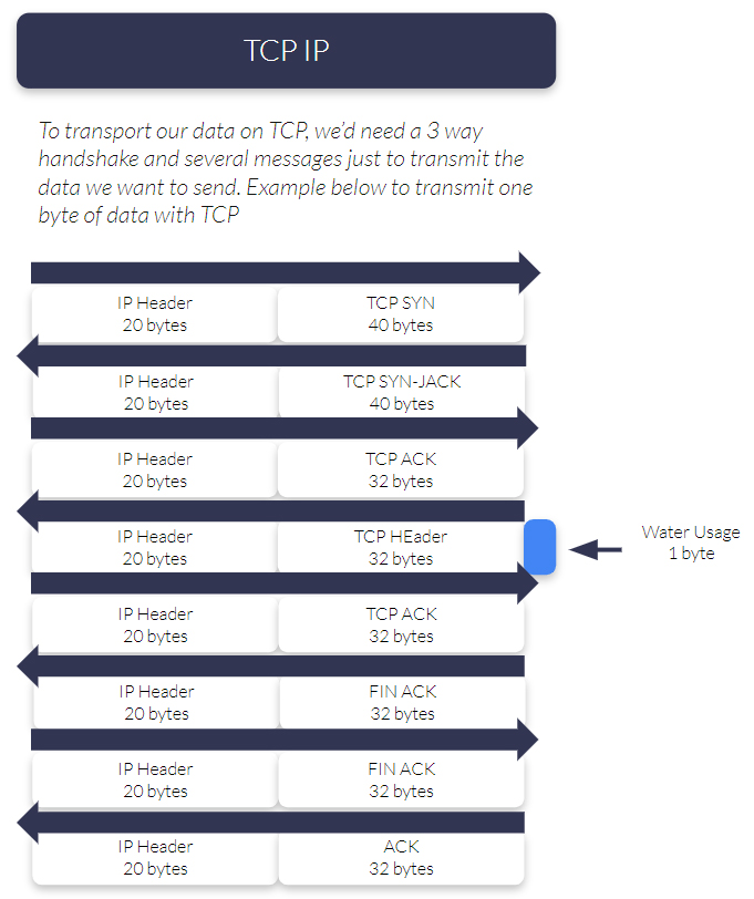
The main challenge is that TCP/IP is inefficient when it comes to transmitting very low volumes of data, and it’s relatively resource-hungry. In the example opposite, you can see how much data is passed back and forth in order to send just a single byte of useful data (thank you to Nick vs Networking’s blog post for this great illustration).
Not only are you paying for the extra packaging and overhead, it might also require more power to transmit than if you were simply transmitting the useful data. Not an issue if your asset / sensor is powered, but it could be if your asset is unmanned, and needs to run off a battery for several years in between maintenance visits.
If you want a more efficient means of passing data because you need to throttle back on cost, and/or your device needs to conserve power, you have four options.
- Optimize your data transmissions
- Explore UDP/IP as an alternative to TCP/IP
- Consider using a more efficient protocol designed for IoT such as MQTT
- Look at a message-based option instead
1. Optimize Your Data Transmissions
We briefly touched on this earlier; it’s popular because – unlike some other options – you don’t have to change the underlying network. Two of the best known satellite airtime options that work on a TCP/IP network are Viasat’s Iot Pro, and Iridium’s Certus 100 service. If all of your other systems use IP, you can effectively plug-and-play to send your data over satellite using these airtime options.
Think carefully about how much of the data you’re routinely transmitting contains information you actually need. Our previous blog post identified five key ways to reduce your satellite IoT connectivity costs. In short, by efficiently managing data usage, adjusting settings based on application requirements, and leveraging edge computing capabilities, you can use TCP/IP more effectively, and reduce your overall satellite airtime costs.
2. Explore UDP/IP-based Applications
If your application can tolerate some missing data, UDP can be a much more efficient means of working with IP. Packets (or ‘datagrams’) are sent via a ‘best effort’ communication method, which doesn’t require that the destination host has ‘accepted’ the data transfer. It’s faster and less resource heavy, but less reliable – delivery is not guaranteed – and there are security challenges too.
Hologram.io has a great blog post outlining the differences between TCP and UDP in more detail. Applications built on UDP tend to favour limited networks with low bandwidth and low availability – CoAP (Constrained Application Protocol) is probably the best known of these.
3. Use a TCP/IP-based Application Designed for IoT
Both HTTP and MQTT use TCP/IP; they layer over additional features specific to the applications that they serve. However, HTTP isn’t optimized for IoT; it’s designed for two machines to talk, not for networking many sensors, and is pretty noisy / talkative when used for the latter. If that’s your only option, circle back to point 1 and see what you can do to optimize your data for transmission.
MQTT, on the other hand, was written specifically for IoT; it uses a publish/subscribe pattern which allows for efficient and reliable data transfer. Individual sensors publish data to a broker, and multiple ‘clients’ can subscribe to receive that data from the broker.
MQTT delivers data with a very low overhead by using a binary format that minimizes message size. You can also choose varying levels of ‘QoS’ – Quality of Service – which allows you to speed up or slow down message delivery, and increase / decrease the certainty of the message being delivered. Basically, fast = less reliable delivery, and slow = very reliable delivery. All of this means your device is using TCP/IP very efficiently and therefore will consume less data.
Among the criticisms of MQTT are security concerns – it doesn’t include a defined security mechanism, relying instead on the underlying network’s security – and a lack of built-in error handling. It’s worth noting that a number of companies working with MQTT have built platforms to manage these specific concerns, including Ground Control’s own Satellite IoT Gateway.
4. Look at a Message-based Option Instead
However efficient your application layer – and MQTT is very efficient – IP, whether UDP or TCP enabled, is still relatively overhead-heavy. If you can avoid using IP altogether, you can further minimize the volume of data delivered, and in doing so, spend less money on airtime, while keeping your battery powered device running longer.
In the cellular industry, this is called (very logically) Non IP Data Delivery (NIDD), and it’s a message-based transmission protocol. With messaging, 100% of the data that is transmitted can contain useful application-related information, and the transmission lasts only as long as it takes to send that data. Compared to IP, it’s like the difference between a text message and a phone call; NIDD is the text message, and IP is the phone call – the latter delivers real time, two-way communication, but is more resource-hungry.
In the satellite industry, a similar principle has been operated very successfully for over 20 years – message-based transmissions that are sent either at predefined intervals, or when requested, or when there has been an ‘event’. Iridium’s Short Burst Data (SBD) and Iridium Messaging Transport (IMT), plus Viasat’s IoT Nano are all message-based.
It’s an extremely efficient way to use satellite airtime: send only what you need, when you need it, with no costly overhead. It does present a data compression (or compaction) challenge for developers: the message sizes are minute, with SBD sending just 320 bytes, and receiving 270 bytes. That can take some creativity to work with – but necessity is the mother of invention! Our SBD-based tracking devices convey date, time, position, altitude, course, speed, battery percentage, temperature, precision in just 17 bytes.
Iridium Messaging Transport – a Game-Changer?
Some of these size restrictions were lifted in late 2022 when Iridium launched IMT. This is still a message-based platform but it allows messages to be sent of up to 100 KB, a vast increase on the previously available options. This allows you to send compressed images and multiple sensors’ data, and so opens the door to message-based transmissions for far more use cases than was previously possible.
Formatting Your Data for a Message-Based Transmission
If you use SBD, you can transmit your data as either ASCII or Binary messages in packets of up to 340 bytes, while receiving packets of up to 270 bytes. Depending on your service provider, you can then deliver messages to your application using a wide variety of protocols. Ground Control’s customers gain access to Cloudloop Data, which supports our HTTP Webhook API, email or integration with public cloud services like AWS SQS. You can find all of the Cloudloop Data documentation here.
If you decide to use IMT, great news: our engineering team have created a Satellite IoT Gateway which allows you to transmit your data using MQTT, but taking advantage of the cost- and power-benefits of the message-based transmission.
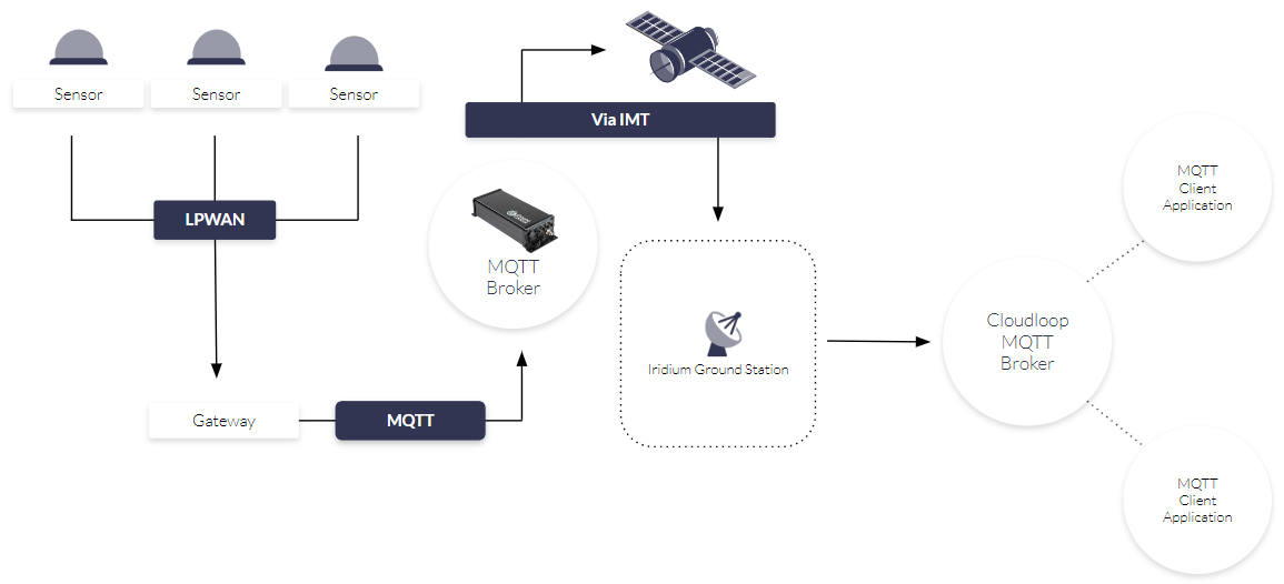
This system uses the RockREMOTE family of satellite IoT hardware. As per the diagram, you can communicate with RockREMOTE using MQTT, and it will transmit the data via IMT, managing the connection, message queuing, retries etc. automatically. It’s then reconstituted on to a secure, cloud-based MQTT broker which you can connect to your MQTT client or library, allowing your cloud application to consume the messages.
Why Would You Use Anything Else?
The main drawback is that, simply, IP-based communication is more common, so if your remote systems – sensors, gateways etc. – utilize IP, you’ll need to do some engineering work to switch to messaging.
Here at Ground Control, we’re invested in making sure our customers use the most cost-effective means of reliably and securely communicating with their remote assets. If your application or protocol expects an interactive, two-way IP connection (i.e. SSH, SFTP, TCP/IP sockets, web browsing etc.), then something like Iridium Certus 100 or Viasat IoT Pro is probably the best fit.
If, however, you’re using MQTT, you can explore IMT; and if you have very small data requirements, you can unlock the most affordable solutions available. We’re here to help, so get in touch if you have any questions about this post, or you’d like some impartial advice.
Can We Help?
If you have a remote data transfer challenge, we would love to help you solve it. Our expertise, in-house hardware, Cloudloop platform and long-standing relationships with satellite network operators and hardware providers gives us the means to tackle challenges with creativity.
We’re not invested in selling you a specific product or connections, just the best solution for your needs. If you prefer to speak to someone directly, call us on +44 (0) 1452 751940 (Europe, Asia, Africa) or +1.805.783.4600 (North and South America).
The Vital Role of LEO Satellites in Safe and Secure UAV Drone Operations
Unmanned Aerial Vehicle (UAV) drones are transforming logistics. The diverse applications range from delivering medicines to people in remote locations, to monitoring offshore wind platforms to identify and communicate possible hazards.
The cost-saving advantages are clear; a drone is less expensive to operate than a manned vehicle, and it’s also safer. Historically, drones have been used in areas that are harder to reach by people. They’re harder to reach because they’re remote: out at sea, on an island, in the mountains or in the desert. This often comes with a side order of weather, radiation and elevation hazards. While a UAV might be negatively affected by these conditions, it’s obviously preferable to put a machine at risk rather than a human!
But drone operation is not without its challenges, chief among them piloting beyond visual line of sight (BVLOS). Without this capability, drones have to remain within sight of the operator, which limits the viability of most commercial applications. To operate safely BVLOS in non-segregated airspace (i.e. airspace shared by manned aircraft), drones must be able to detect and avoid other airspace users, reliably communicate with all stakeholders (the remote pilot, plus other aircraft and ground control), comply with relevant air traffic control regulations, and adapt to changing situations.
Certification is currently managed on a case-by-case basis, and can take years. Satellite network operator Iridium recently published a white paper calling for a Minimum Equipment List (MEL) that, if adhered to, would allow drone operators to fast-track certification and operate safely in designated airspace. In the meantime, the UK’s Civil Aviation Authority (CAA) is working on a regulatory framework that will enable specific category BVLOS operations in non-segregated airspace by 2026.
Until these initiatives bear fruit, scaled drone operations will continue to take place within well-defined and controlled operating areas, reducing the risk of conflict with other aircraft. For example, the newly implemented European Standard Scenario (STS) allows drone operators to skip the EASA’s risk assessment and authorization process by restricting altitude, flight paths and operational hours. Both pilots and the drones must meet certain standards, which include failsafes for communication: you must be able to reestablish a data link in the event that it fails, or else be able to remotely terminate the flight (source).
Communication with drones operating BVLOS
Where available, drone operators will use airborne VHF / UHF / L-Band radio, or some form of cellular connectivity to communicate with their drones. But these radio frequencies may suffer from congestion, security challenges and regulatory limits. As many drones are used in unpopulated areas, cellular may simply not be an option. So connection redundancy is an increasingly important element of BVLOS operations.
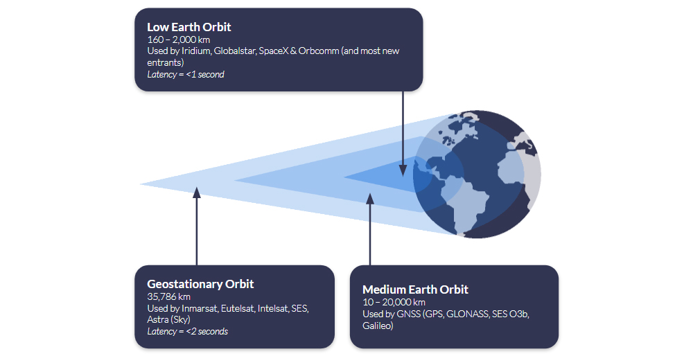
This is where LEO – Low Earth Orbit – satellite communication comes into play. Satellites launched into Low Earth Orbit are closer to the Earth than their geostationary counterparts. This has important implications for drone operators, because the latency – the time it takes a message to be sent to the drone from the operator, and received (or vice versa) – is reduced from c. two seconds to less than one second.
As this diagram shows, very few satellites are needed to cover huge swathes of Earth if the satellite is far enough away from it, but satellites in Low Earth Orbit cover only a small portion of the Earth’s surface. Multiple LEO satellites are needed for global coverage, and the first – and to date only – globally accessible satellite IoT network is Iridium. This is why Iridium is so often the choice for UAV manufacturers looking to add failover communication to their drones.
Iridium offers multiple airtime options for connecting to their satellites, from Certus 700 (700 Kbps, fast enough to support live video broadcasts) through to Short Burst Data (packet-based data which sends 270 / 340 bytes per message). Short Burst Data (SBD) is ideal as a failover connection; with SBD, operators can get position, altitude and speed, and can return basic commands such as ‘go to the nearest rally point’, ‘go home’ or ‘terminate flight’.
SBD is lightweight, low power consuming, and meets most SWaP requirements for UAVs. It offers a secure and reliable connection to the drone to make it less vulnerable to hacking, and safe to pilot within controlled operating areas.
Our team visiting Zipline in late 2023
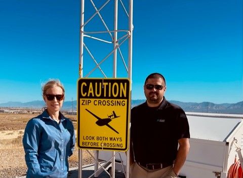
Supported by satellite IoT connectivity, important work is already taking place. Our customer Zipline is using SBD as the failover communication method for its Zips: autonomous aircraft that are being used to deliver prescriptions, groceries, vaccines, livestock supplies and more.
Very recently, Zipline was cited in the peer-reviewed journal Vaccine, noting that its method of delivering vaccines aerially to more isolated parts of Ghana has improved clinical outcomes and prevented disease among children.
In fact, it’s estimated that Zipline delivery has saved an estimated 727 lives in the Western-North Region by enabling 15,000 children to access vaccines who would not previously have been able to.
Popular Youtuber Mark Rober filmed his experience at Zipline, and it’s well worth a watch to learn more about this incredible operation.
To deliver vital chemotherapy drugs to patients on the Isle of Wight, UK-based Skylift UAV built an autonomous eVTOL (electric, vertical take-off and landing) aircraft which can fly for 1.5 hours on a single charge, with a maximum speed of 100 Mph. In BVLOS configuration, it can travel up to 100 Km, depending on the payload.
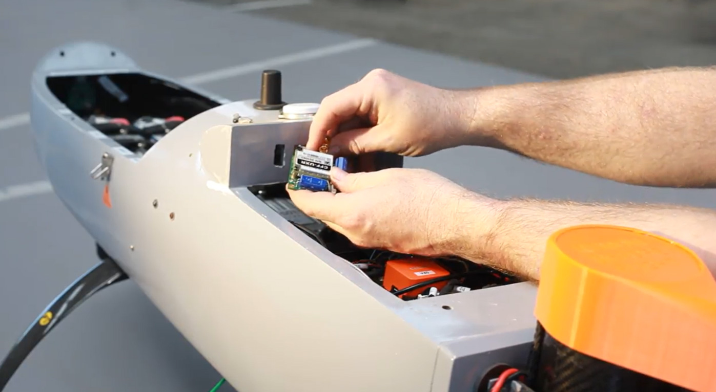
The drones are autonomous, but monitored by Skylift’s safety pilots who can take control of the drone at any time. As the drone travels BVLOS, and across a body of water (the Solent), it’s essential that the pilots have two reliable means of communication with the drone at all times. The Skylift UAV team chose the RockBLOCK 9603 to deliver SBD connectivity in addition to aviation-grade L-Band radio to ensure that irrespective of the drone’s location, connectivity is guaranteed.
RockBLOCK allows them to send and receive data from the aircraft, and is part of the robust communications package with which all Skylift drones are equipped. It’s also the final line of defence for mission success.
Would you like to know more?
If you’re building a drone and you’re looking for a failover communication method, we can certainly help. If your requirements are more data-hungry than simple commands – perhaps you need to be able to transmit imagery, for example – speak to our team to find out what options are available to you.
We have over 20 years’ experience in satellite connectivity, and specialise in IoT and tracking applications. We’re standing by to ensure you get the service you need.
Satellite Asset Tracking for Construction Projects
Construction companies operate a diverse range of costly machinery and tools crucial for project success. Delays in locating or maintaining these assets can lead to disruptions, missed deadlines, and tripled costs due to unplanned maintenance.
LoJack’s recent study pinpoints the most stolen equipment as wheeled or tracked loaders, towables, excavators, trailers, and utility vehicles. The National Equipment Register underscores the financial impact, averaging $30,000 per theft incident. In short, asset tracking is integral for risk mitigation in construction.
However, traditional asset tracking methods often prove inadequate for the demands of the construction industry, which, according to McKinsey, has historically lagged in digitization. Relying on manual record-keeping and periodic inspections, firms have limited real-time visibility into assets’ location and their status. Manual tracking, often paper-based or spreadsheet-driven, becomes time-consuming and error-prone in the fast-paced construction environment, where assets frequently relocate. Inaccurate, untimely tracking data then challenges resource optimization, leading to under-utilization, and increased inefficiencies, and leaves construction sites vulnerable to theft and unauthorized usage.
Satellite connectivity emerges as a crucial solution for construction asset tracking, particularly considering the diverse and often remote locations of building projects. Only about 15% of the Earth’s surface is covered by terrestrial networks, and construction sites are notorious for poor cellular service. In remote or challenging terrains, where theft and accidents are exacerbated, satellite connectivity becomes key for effective asset tracking and monitoring.
Benefits of Satellite Asset Tracking
PROMOTING WORKER SAFETY
Satellite asset tracking is crucial for ensuring safety on construction sites, where inherent risks demand proactive measures. By offering real-time location insights, this technology acts as a guardian, facilitating swift responses in emergencies. Improved safety is evident as satellite tracking provides constant information about the location of workers and equipment, preventing accidents and ensuring a secure environment. So much so, that a recent study revealed a remarkable 14% reduction in accident costs for construction companies after implementing asset tracking solutions.
Moreover, specialized alerts on personal tracking devices, such as the RockSTAR, contribute to enhanced worker safety. For instance, the timer alert allows workers to set a specific time interval. If there is no further interaction with the device within that time, the RockSTAR automatically sends a ‘timer alert’ to the server or first responders. This feature adds an extra layer of protection by ensuring timely response in situations where immediate action might be required.


COUNTERING EQUIPMENT THEFT
The construction industry faces a substantial issue — equipment theft, costing an estimated $1 billion annually. A recent survey underscores the severity, with 21% of industry professionals reporting weekly incidents of theft. Beyond financial losses, these thefts lead to project delays, shutdowns, and pilferage of raw materials.
Fleet tracking emerges as a powerful deterrent against the risk of asset theft and unauthorized use. Any unauthorized movement can trigger immediate alerts, facilitating prompt intervention, and enabling teams to alert authorities to the location of stolen assets. This also increases the chances of recovery.
STREAMLINING OPERATIONS
Investments in heavy machinery and fleet vehicles constitute a substantial portion of operational costs. Satellite fleet tracking software serves as a powerful tool, centralising data and offering nearly real-time insights into asset utilization from any location. This efficiency translates to precise payroll and cost projections, providing construction companies with accurate work times and utilization reports.
Moreover, asset tracking facilitates efficient inventory management by supplying accurate data on tool and material availability and usage. Additionally, asset tracking systems aid construction firms in regulatory compliance by maintaining precise records of equipment usage, maintenance, and inspections — a crucial aspect for audits and compliance adherence.

EQUIPMENT UTILIZATION MONITORING
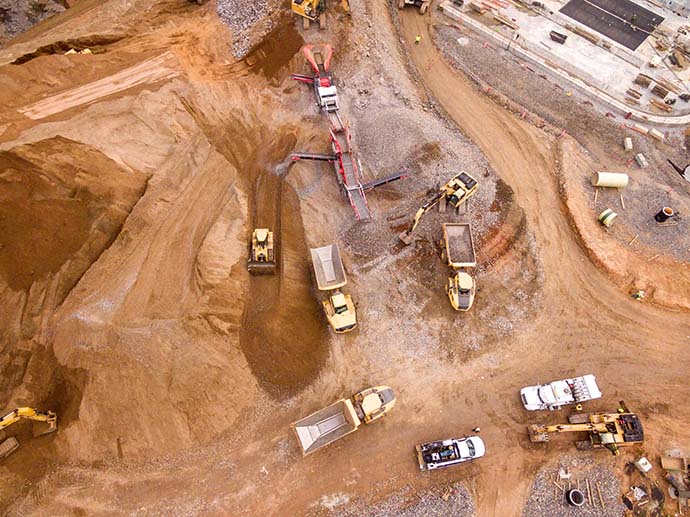
Satellite fleet tracking plays a pivotal role in Equipment Utilization Monitoring (EUM) for the construction sector. With 45% of construction businesses identifying resource management as a challenge, real-time visibility through satellite tracking could prove valuable. Project managers gain instant insights into the location and status of construction assets, facilitating optimal deployment and utilization across various worksites.
This not only enhances worksite productivity but also addresses the challenges of delivering projects on time and within budget, making satellite fleet tracking a key component for effective equipment utilization monitoring in the construction industry.
PROACTIVE MAINTENANCE
Satellite tracking enables firms to conduct proactive maintenance, offering substantial benefits such as cost savings from reduced unplanned equipment breakdowns and minimized repair expenses.
The high adoption rate, with 76% of construction companies utilising fleet tracking and 73% deeming it extremely valuable, underscores its efficacy. The advantages include reduced downtime, improved equipment reliability and availability, lowered long-term maintenance costs, enhanced safety, and increased equipment longevity. This technology facilitates a proactive approach to maintenance, ensuring construction companies achieve optimal performance, mitigate risks, and realize substantial financial savings in the long run.

Satellite Trackers for the Construction Industry
Meet the Iridium Edge Solar
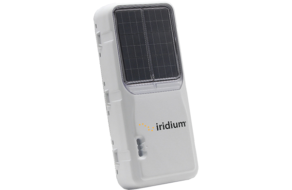
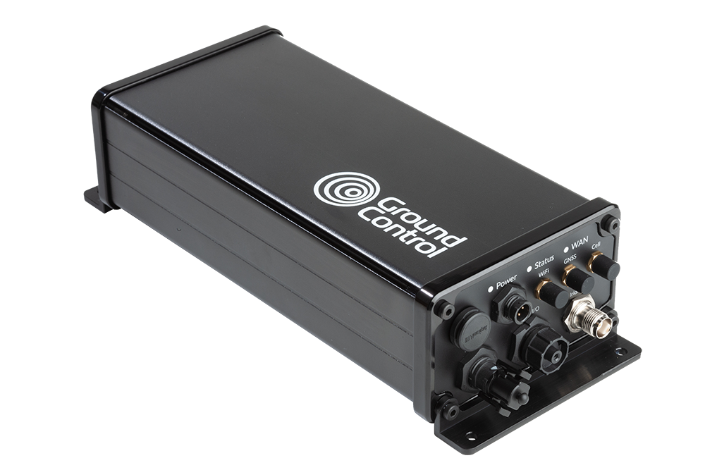
The Iridium Edge Solar is a great choice for those in the construction sector due to its ruggedized, solar-powered, and two-way communications capabilities. Specifically designed for long-term deployment in remote areas, it boasts remote configuration capabilities and military-grade packaging, making it an ideal solution for asset management in challenging construction environments. With real-time GPS tracking and local wireless sensor and communication capabilities via Bluetooth, it provides comprehensive visibility into the location and performance of construction equipment.
Its 10-year deployable lifespan aligns perfectly with the extended timelines often associated with construction projects. By utilising Iridium Edge Solar, construction companies can optimize the efficiency, safety, and productivity of their sites. The device facilitates real-time tracking of equipment locations, proactive monitoring of performance to identify potential issues, and immediate alerts to operators if the equipment is being used in a risky manner. Additionally, it enables data collection for refining safety procedures and training.
Introducing the RockREMOTE range
For larger data requirements, Ground Control’s RockREMOTE delivers real-time power generation reporting, prevents production stoppage by issuing alerts on machinery failure, and facilitates measurements at potential new sites lacking power.
The waterproof RockREMOTE Rugged, boasting an IP67 rating, enables firms to monitor and manage remote assets like mobile generators, ideal for critical communication in remote scenarios. Customers have flexibility, choosing between Ethernet, Wi-Fi, or Serial RS232/485 for communication interfaces.
Both devices support dual-mode Iridium Certus satellite connectivity combined with LTE, providing the construction industry with robust and globally accessible asset tracking capabilities.
Ready to Build Smarter?
Gain real-time visibility, enhance security, and streamline resource management in any location, even beyond terrestrial networks. Our proven devices empower construction workers with reliable and efficient tracking capabilities.
Ready to transform your construction operations? Explore Ground Control’s satellite asset tracking solutions today.
Will satellites guide Santa’s sleigh tonight?
Not enough thought is given to the practicalities of Santa’s epic sleigh ride, in our view. Living at the North Pole, how does Santa receive all of the emailed letters he’s sent every year? How many carrots does a reindeer actually need to fly around the world? How does Santa avoid flying through the worst of the winter storms in the Northern Hemisphere? And how on earth is he sending “LIVE Christmas Eve updates from the Reindeer and me!” (https://twitter.com/OfficialSanta)?
It’s obvious when you think about it. Only satellite connectivity allows Santa to remain connected wherever he goes on the globe, checking in with his team and Mrs Claus, maintaining the reindeers’ health, and ensuring that every child on the nice list gets a gift. And, in this instance, it’s Iridium satellite connectivity, with its coverage at the polar regions being a must-have!
Without taking any of the magic away from the most wonderful time of the year, our infographic lays bare the communication challenges that Father Christmas solves with portable satellite internet and satellite tracking devices.
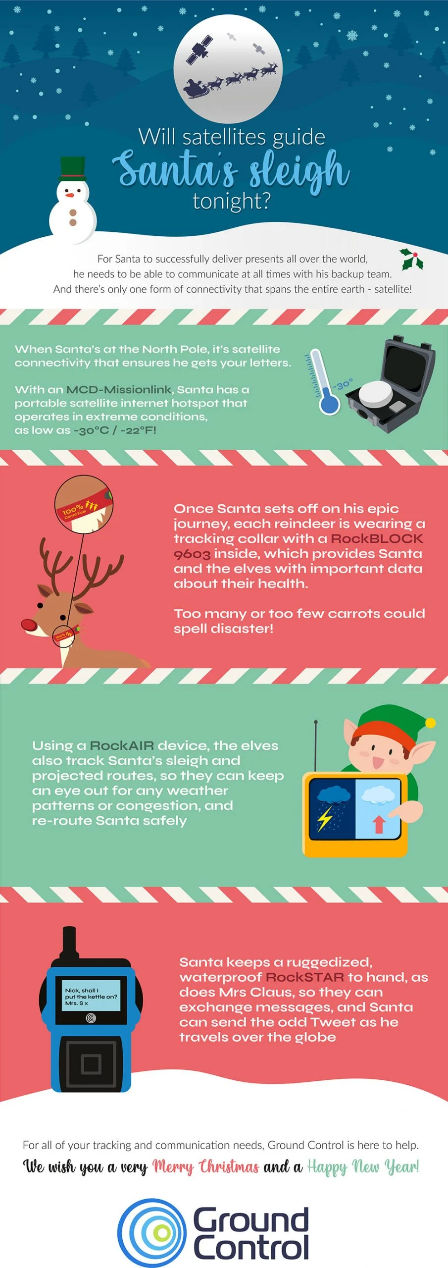
To echo the sentiment of the infographic, we wish all of our customers, staff, and website visitors a safe, happy and healthy Christmas and New Year.
If you’re interested in learning more about Santa’s enviable satellite set up, here are the links: MCD-MissionLINK | RockBLOCK 9603 | RockAIR | RockSTAR
Can we help you with your connectivity challenges?
From data buoys to camel tracking, if you have assets in a remote area, we can help you communicate with them. We design and build all of the satellite IoT and tracking devices Santa uses in this infographic, and we work with the leading satellite network operators to ensure our customers get the best service for their requirements.
If you would like impartial, expert advice on the most cost-effective, reliable, secure and efficient means of transmitting your remote data, get in touch!
RUDICS vs Certus 100: Is it time to make the switch?
Iridium RUDICS (Router-Based Unrestricted Digital Internetworking Connectivity) was devised in the early 2000s as a means of allowing remote devices to connect to internet-connected servers using TCP/IP. The previous system, dial-up data, had a hefty overhead every time the service was activated, as a series of checks needed to take place before data could be transmitted.
RUDICS improved upon this by connecting the call to a predefined IP address, dispensing with the checks, and making connection almost instantaneously. This had the advantage of requiring less power at the remote transmitter end, lowering latency, and generally being a more efficient means of accessing the Iridium system.
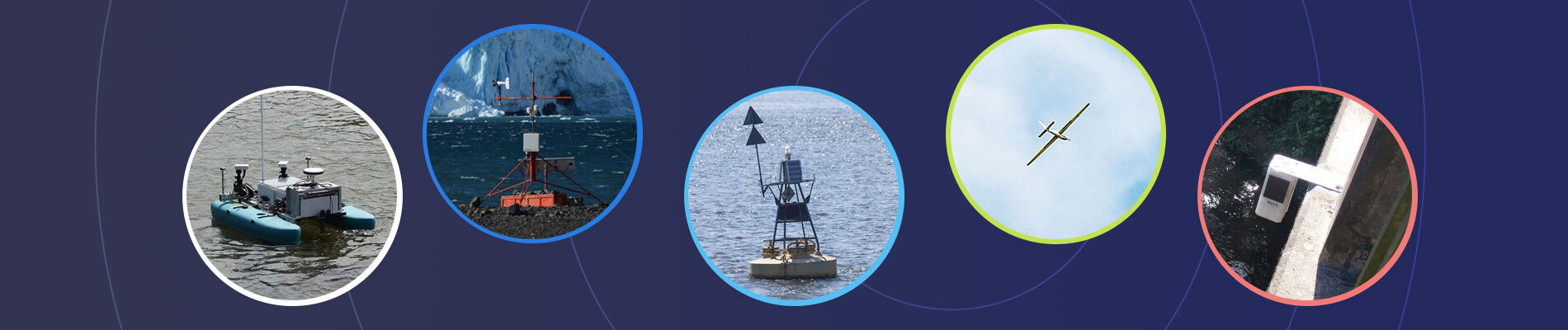
RUDICS was – and still is – used for solutions that have multiple remote units in the field reporting back to an end point. Data buoys, water level stations, Unmanned Autonomous Vessels (UAVs), geotechnical and structural monitoring solutions, weather stations and many more applications have relied upon RUDICS for two-way communication for close to two decades.
In 2019, Iridium launched its (at the time of writing) newest satellite capability, Iridium Certus. Leveraging the advanced technology on the latest generation of Iridium satellites, Iridium Certus is available in three speed classes: Certus 100, which is intended for IoT applications; Certus 200, which is good for basic internet and voice, and Certus 700, which delivers the fastest L-band internet broadband speeds currently available, up to 704 kbps.
When we’re comparing RUDICS to Certus, we’re exclusively talking about Iridium Certus 100. They’re both aimed at the same use case of connecting remote devices to servers using TCP/IP (although Certus 100 has an alternative option here – more on that later).
What are the key differences between RUDICS and Certus 100?

Certus 100 has faster data speeds
RUDICS transmits data at 2.4 Kbps; Certus 100 transmits data at 22 Kbps, and the downlink is 88 Kbps – almost 40 times faster. This means that you can transmit more data, more frequently.
Costs / billing mechanism
RUDICS is charged per minute, rather than the Certus 100 charging model of per byte of data transmitted. This makes RUDICS more expensive than Certus 100 for many applications; it’s possible, even probable, that you’re paying for connectivity time you don’t need.

RUDICS is circuit-switched
RUDICS is circuit-switched, which means the ‘call’ between the remote device and the server has to be maintained. It’s not fault tolerant if your view of the satellite is temporarily obscured, or the server goes offline.

Certus 100 is packet-switched
Certus 100 is a packet-switched network, sending data in small and optimized packets which are much less likely to be ‘dropped’ mid-transmission.
In our view, there are very few instances where Certus 100 will not present a more reliable, cost-effective and scalable solution for remote data transfer than RUDICS.
It doesn’t stop there: while Certus 100 supports TCP/IP-based connectivity, it also offers users the ability to send data via Iridium Messaging Transport (IMT). This is a message-based transmission protocol which allows you to send and receive messages of up to 100,000 bytes.
This could facilitate additional sensor readings, greater data resolution, photographs or even low-resolution video. Just as importantly, sending data via IMT will substantially lower the cost of data transmission because there’s no TCP/IP overhead in a message-based service; you’re only billed for your (successfully delivered) data payload.
Get in touch
If you’re currently using RUDICS, let’s talk: based on your current data usage we’ll be able to advise if you can save money by switching to Certus 100, and we can work through any technical implications of doing so.
We’ve been Iridium partners since 2005, so we’re well placed to provide you with an experienced, objective perspective on the right connectivity solution for you.
Elevating emergency operations: SATCOM’s role in transforming public safety
First responders – firefighters, paramedics, police, all public safety agencies – must have communication certainty. Why?
- Timely instructions reaching field teams can mean the difference between a life saved and a life lost.
- In distress situations, personnel staying connected is essential.
But 81% of emergency managers have experienced communication failures. During an emergency, traditional infrastructure may be unavailable, destroyed or overloaded. This is why satellites play such an important role in public safety operations. In just one example, the FBI and other emergency response teams relied on satellite phones throughout the Boston Marathon Bombing aftermath because cellular service was unreliable due to congestion.
SATCOM products and services provide reliable and resilient connectivity, enabling critical communication links when LTE and radios are down. With the ability to provide connectivity in remote, disaster-stricken, or otherwise challenging environments, SATCOM has already revolutionized how first response agencies operate.
How SATCOM has transformed public safety operations
Situational Awareness
Leveraging satellites, incident commanders have a reliable means of communicating with personnel in the field. This ensures real-time dissemination of information, so commanders’ can maintain situational awareness – vital for shaping a timely, appropriate response.
Emergency Response Planning
Ground personnel rely on vital information regarding population density, infrastructure, and environmental conditions. Satellite connectivity enables efficient data collection, analysis, and modeling, aiding effective response strategies and resource allocation.
Asset tracking and Management
Real time satellite-based asset tracking systems provide constant updates on the location and status of vehicles, equipment, and personnel. This optimizes resource management, boosts operational efficiency, and improves the safety of field team members.
Video and Data Transmission
Satellites facilitate seamless transmission of HD video and vital data from Unmanned Aerial Vehicles (UAVs) and sensors, plus access to extensive reports, images and maps. Allowing real-time collaboration, swift decision-making, and remote guidance for on-site personnel.
Today, SATCOM aids tactical operators with natural disaster response both as a primary and failover means of communication. It empowers wildfire response teams operating in remote forests with real-time communication, data analysis, and information retrieval. It enables field hospitals to access medical histories, transmit imagery, and provide telemedicine services on-site.
However, in a competitive market with a growing number of players, choosing the right SATCOM service and equipment can be difficult. Using our 20+ years experience supporting first responders, we’ve outlined key considerations to help guide public safety agencies define their SATCOM requirements.
Navigating the world of SATCOM: Important factors to consider
Coverage & Availability
As SATCOM systems leverage specific satellite constellations and services, it’s crucial to assess your agency’s operational zone to determine coverage and availability needs.
Coverage will depend on factors like satellite orbit position, antenna pointing accuracy, frequency used, and potential signal obstacles such as tall buildings or valleys. Key players like Iridium, Starlink, and Viasat offer global coverage (the latter excluding polar regions).
However, Starlink can suffer congestion-related slowdowns, while newer constellation OneWeb consistently covers the 35th parallel north, encompassing Canada, southern Europe, and northern USA, without speed fluctuations.

Bandwidth & Latency
Effective communication for first responders often extends beyond voice calls. Thus, teams must assess whether their SATCOM devices require capabilities like live video transmission. In such cases, prioritizing sufficient potential bandwidth and, where needed, low latency becomes essential.
Both Iridium and OneWeb constellations operate within Low Earth Orbit (LEO), resulting in reduced ping times due to closer satellite proximity to Earth’s surface. With latency as low as 70ms, emergency responders experience near real-time collaboration.
Viasat, SES and Intelsat support high bandwidth applications like video calling, but with constellations situated in geostationary orbit, there is a slight impact on latency.
Ruggedness & Mobility
First responders often navigate challenging and unpredictable environments. Fortunately, SATCOM equipment can be ruggedized to endure demanding and rapidly changing conditions. Look for robust IP (ingress protection) ratings, and operating temperatures to ensure steadfast performance during critical moments.
If you need extremely swift deployment and setup, consider a case-based device like the MCD-4800, which allows responders to establish communications within seconds during emergencies.
The Kymeta Hawk u8 LEO, which attaches to vehicles, offers Satcom-on-the-move capabilities—an essential feature given that a recent survey showed 37% of first responders consider connected vehicles a top priority within the next five years.

Interoperability
Seamless communication between different agencies remains a top concern for our public safety officials, with 47% of surveyed first responders recognizing the significance of interoperability. Coordinated communication among federal, state, and local agencies is essential to prevent duplication and delays in rescue efforts.
With SATCOM systems, agencies can achieve interoperability in two main ways: 1. Employing an “interoperability gateway” or crossband repeater. 2. Utilizing Mission-Critical Push-to-Talk (MCPTT) devices. Planning the “how” is essential from the outset.
Security
The transmission of sensitive data is a crucial aspect of first responder operations. To safeguard this information, the chosen SATCOM service should prioritize network security and provide robust encryption features, to ensure the confidentiality, integrity, and availability of the transmitted information.
Look for systems and services that offer end-to-end encryption, secure communication channels, and authentication mechanisms to protect data from unauthorized access. For instance, OneWeb’s service boasts military-grade network security, and some ground stations are even located within military installations.

Survey referenced above: Frontline Public Safety Communications
SATCOM equipment is a tool; selecting the right tool can make a substantial difference. And with first response teams expecting their job to require even more connected devices in the next five years, the better agencies understand their needs, the better companies like Ground Control can match agencies with the best possible tool (SATCOM equipment).
For more detailed comparisons of our popular portable and mobile satellite communication equipment, refer to – Comparing SATCOM solutions for public safety agencies. Likewise if you would prefer to discuss your requirements with one of our experienced team, email us at sales@groundcontrol.com.
Ready to take the next step?
With Ground Control, our customers have access to individuals who have not only been working in SATCOMS for over 20 years, but those who have been working alongside first responders for over 20 years. Some of us were even first responders in a previous life.
So if you are reviewing satellite communication equipment and would like some objective advice, simply fill in the form and one of our expert team will get back to you.
Wireless connectivity for offshore wind farms: why it matters, & how to get started
Offshore wind is growing. Pioneered by countries bordering the North Sea – the UK, Germany and the Netherlands – China now leads the world in offshore wind energy production, with 23.9GW of capacity. The United States has started to take an interest, with President Biden committing to building 30 gigawatts of offshore wind projects by 2030 – which will power more than 10 million homes with clean energy. And Brazil has an ambitious programme to build 72.2GW of capacity, dwarfed only by the UK’s planned additional 78.5GW.
The benefits of offshore wind are clear: higher and more consistent wind speeds, unhampered by mountains or buildings, ensures consistent and high energy output. But the costs are substantial. The harsh marine environment means that the turbines are at far higher risk of damage from corrosion and oxidation. Plus, making repairs is harder, more expensive, and more dangerous than onshore wind. As a result, the cost of offshore wind production is far higher than solar or onshore wind: $133 per MegaWatt hour for floating turbines and $78 for fixed-bottom turbines, compared to $34 per MegaWatt hour for onshore wind (source).
We believe satellite IoT has a role to play in both lowering the cost of production, and improving the safety of workers. Here’s how.
Why is offshore wind production relatively expensive?
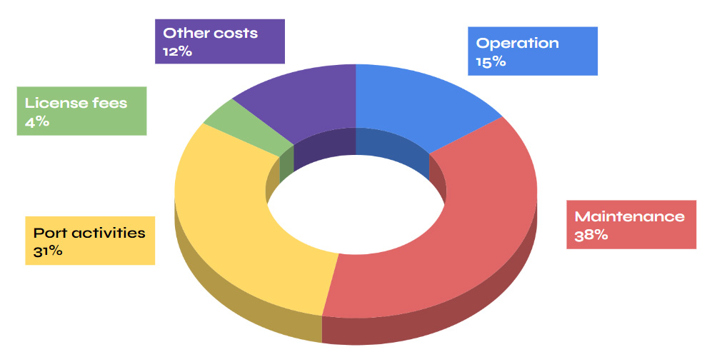
A chunky 38% of the operating costs of offshore wind farms is allocated to maintenance. What’s contributing to that cost?
- Equipment failure: on average, each turbine will experience 8.3 failures every year, comprising 6.2 minor repairs, 1.1 major repairs, and 0.3 major replacements
- Manpower: on average, it takes 116 days and 9 technicians to undertake a major replacement, and 7 days and 3 technicians for a minor repair. Delays are frequent, due to ‘no access days’ caused by bad weather
- Ageing equipment: some analysts project that opex costs increase from £184,000 per MegaWatt per year when the turbine is new, to £426,000 per MW/Year when the turbine is 15 years old.
What can be done to reduce these costs?
The best answer is predictive maintenance. Supervisory Control and Data Acquisition (SCADA) systems allow operators to monitor and act upon failures or poor performance, and more advanced data collection and analysis allows maintenance tasks to be predicted.
Predictive technologies include Condition Monitoring Systems (CMS). These capture and analyse as much as 250 physical data points, including torque and force measurements, acoustic emissions, electrical strain gauges, oil particle counters and main bearing damage. Sensors capture the data, then AI or machine learning is used to improve the accuracy of the predictions and reduce false alarms as the system is embedded, and the installation base grows.
The benefits for utilising CMS are clear to see, with one monitoring system provider claiming that 90% of developing faults are detected 5 months before failure, driving 175% annual ROI from greater uptime, and reducing emergency maintenance trips by up to 50%.
Predictive maintenance drives 175% annual ROI for offshore wind farms
Further, improving quality control reduces the risk of accidents, which could then reduce insurance premiums.
A key part of this process is the transmission of the sensor data to the cloud, and from there to the client’s IT system, where the data is collected, stored and analysed.
Sensor data is often transmitted through underwater cables, which offers many benefits: it’s fast, secure, and can carry a large amount of data cost-effectively. However wired communication does have drawbacks that can be resolved by co-locating a wireless solution.
Wired vs. wireless or wired plus wireless?
If you already have a wired connection to your wind farm, it’s worth considering a wireless system to complement it, because the ease of adding new sensors to a wireless network is far greater than trying to wire in additional points into a legacy system. You simply need to place your sensors where they need to be to capture the required data, and switch them on. With no need to run cabling, you’re saving time and money, and benefitting from the additional sensor data faster.
Further, because you’re creating a dedicated wireless network for your SCADA data, its findings can be transmitted independently of other data sources. This provides both resilience in the event that your wired connection is disrupted, and allows you, if you choose, to put bespoke security measures around your OT data stream.
In addition to which, you can speed up the rate of data transmission from the industry standard of every 10 minutes, to virtually real time. In turn, this ensures that your maintenance teams get close to real-time information to help inform decisions on what issue to address, when. In fact, Turbit estimates that you can increase output by up to 5% by applying corrective measures faster.
If you were building a new offshore wind farm and decided to use only wireless connectivity to connect your assets, it can cost as little as 10% of the wired alternative, as well as being faster to implement. That said, while the cost of installation is far less, satellite and cellular connections generally come with a monthly usage fee, and they’re only suitable for relatively small amounts of data. For this reason, in our experience, most operators are exploring hybrid wired and wireless setups.
But adding a wireless network isn’t always straightforward for offshore wind farms, as they may fall outside the reach of cellular networks. 4G/LTE services typically extend to around 12 nautical miles from the coast, and wind farms can be built up to 43 miles offshore, which leaves a gap.
That gap can be bridged with a private cellular network, which offers great throughput and tight data security, but this is expensive and time consuming to set up.
Wireless connectivity options for transmitting IoT data from offshore wind farms
LoRaWAN coupled with satellite connectivity is getting an increasing amount of attention for this application. LoRa networks are very easy to set up, and have a wireless range of approximately 16km. They’re specifically designed for IoT data so LoRa-enabled sensors have very long battery lives, but very small data-throughput.
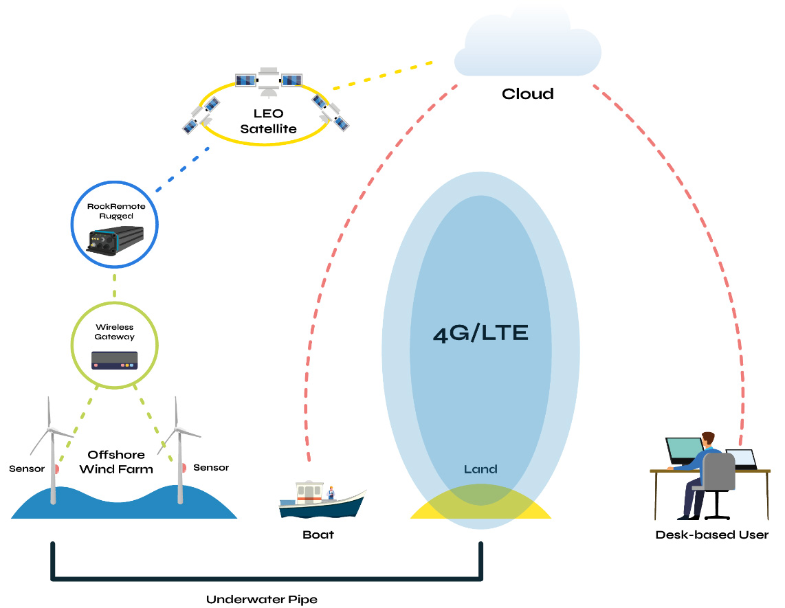
Aggregate each turbine’s sensor data in a LoRaWAN gateway, and then use a single satellite transceiver to transmit the data into the cloud. This is easily achieved with technology that’s widely available today. For example, a device like the RockREMOTE Rugged can be placed almost anywhere on a turbine, as its omni-directional antenna connects with the Iridium satellite network: if the turbine moves, there’s no loss of connection.
This combination of a Wide Area Network and satellite means that most turbines don’t need a specific piece of hardware to communicate to the satellite network: only one, the ‘master’ turbine, needs this, along with the gateway. The gateway can help to lower the cost of data transmission by providing edge computing capabilities: reporting on exception, for example, ensures that only data points falling out of agreed parameters is transmitted.
Is satellite data transmission expensive?
Because of the recent proliferation of satellite network operators, including Starlink and the soon-to-be-launched Amazon Kuiper Project, the cost of sending your data via satellite has substantially decreased. Existing network operators who have proven their reliability over many years have diversified their product offering to ensure that they can remain competitive with the new entrants (read more about satellite connectivity costs).
As an aside, another great benefit of working with established network operators like Iridium and Inmarsat is that their data transfer mechanisms are trusted by governments and militaries worldwide. As wind farms can be considered critical national infrastructure, and are expected to become more attractive targets for cyber-crime in the near future, knowing that you have access to highly secure data transfer options is very important.
Who else benefits from wireless sensor data transmission?
In addition to the operations team receiving, interpreting and actioning the CMS’ recommendations, another ‘customer’ of wireless sensor data and analysis are the maintenance crews. Frequently located onboard offshore support vessels (OSVs), these people are indispensable for the smooth running of offshore projects.
The same data being captured from sensors and transmitted via satellite to the cloud can also be transmitted to the OSVs. By receiving the data directly, they’ll benefit from being able to effectively triage tasks, without having to wait for instructions from an on-shore team. Real-time wind, humidity, wave height and weather pattern measurements are also essential for maintenance workers’ safety. This sensor data doesn’t need to travel through a fibre connection, as the main requirement comes from the maintenance teams for whom this is critical information.
Recommended OSV satellite IoT hardware
While OSVs usually have a heavyweight VSAT system for crew communication, we’d recommend a separate, lighter-weight system for the transmission of IoT and tracking data, both as a failsafe and to use the bandwidth more efficiently.
The Thales VesseLINK is an ideal for solution for this purpose. It utilises the Iridium satellite network which has 100% global coverage, and the antennas are omni-directional, meaning there’s no need to re-point the device when the OSV moves. Because the network is in Low Earth Orbit (LEO), the latency is low – less than one second. Coupled with the fact that it uses the L-band frequency to transmit data, which is unaffected by weather conditions, Iridium-enabled devices are ideal for mission-critical data.
The Thales VesseLINK is available in two versions: the VesseLINK 200 and VesseLINK 700. The difference between them is the data speeds: the former is designed for IoT data and basic voice / internet access, with data speeds of 176 Kbps. The latter delivers high-speed internet with speeds of 700 Kbps, and creates a WiFi hotspot for any device within a 300 metre range. So it’s capable of far more than transmitting IoT data, but will do so under any conditions.
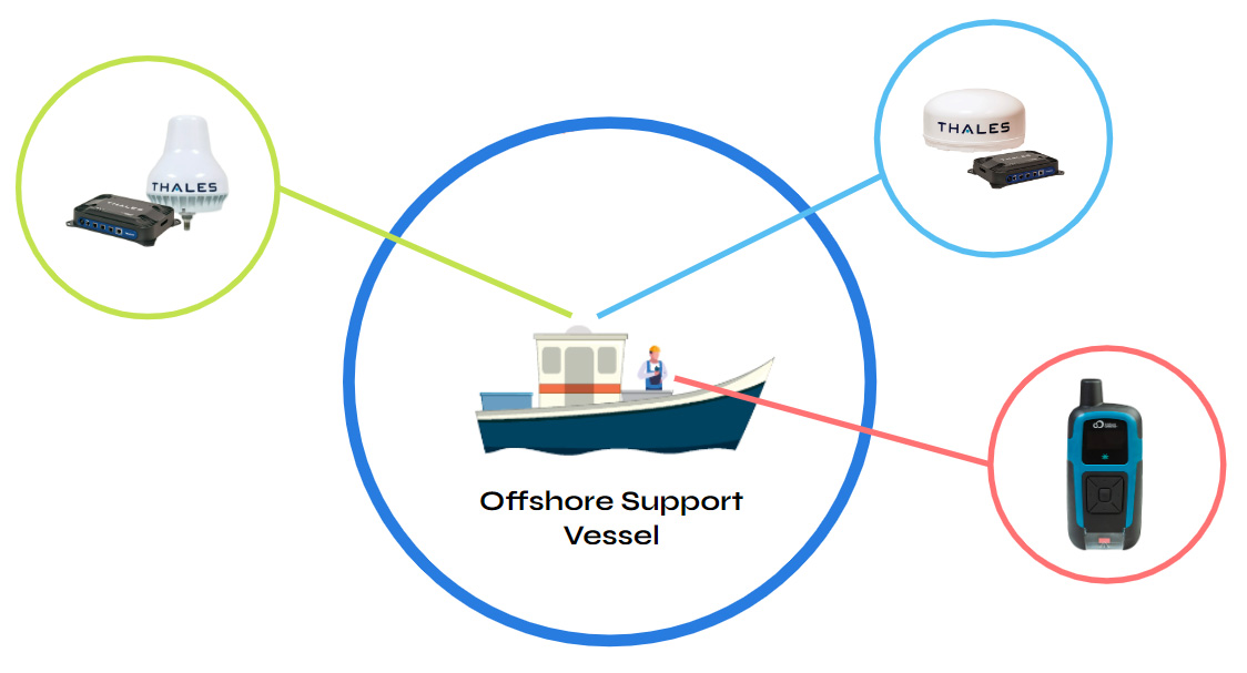
Another satellite transceiver we’d suggest exploring is the RockSTAR. This handheld device can connect to wearables sensors like heart rate and body temperature monitors. It also features two-way messaging and an SOS feature. Again using the Iridium satellite network, this data can be transmitted to safety teams to allow for timely inventions, where needed.
Primary, secondary or failover communication
A final note regarding satellite connectivity for your offshore wind farm: it’s highly effective as a back-up communications mechanism should anything happen to your primary means of connecting with the turbines. Underwater cables can be damaged by trawlers, the environment or even malicious intent. With satellite as a back-up, you can still shut down or kickstart your turbines as needed, and communicate with your workers. It’s instant infrastructure that isn’t affected by weather, has no dependency on terrestrial networks, and is highly secure.
Talk to the experts
We’ve worked with renewables companies and instrumentation manufacturers for decades, and have seen satellite IoT transform over the years; but never more rapidly than it is right now.
We can help you make sense of a changing ecosystem and make choices that will continue to deliver for you well into the next decade. Get in touch, and we’ll provide you with objective, expert advice.
Unleashing Precision Forestry: how Satellites Facilitate Decision-Making and Automation
While the Mining industry has been applying advanced analytics and AI to its operational technology for some time, Forestry has lagged behind in terms of digital data capture, automated operations and optimised decision-making made possible through advanced analytics. But the times are changing.
As McKinsey identified in a 2018 article, the increasing technical sophistication of Forestry’s main customers – pulp, paper, transportation, sawmills, timber traders etc. – has driven the adoption of precision farming technologies. Further, early adopters have used their greater yields and reduced costs as a competitive advantage.
An example of the value of real-time data capture is seen in the mechanised harvesting cut-to-length (CTL) system, evolving in Scandinavia. Traditionally, tree felling and log manufacture are carried out by an operator with a chainsaw; tree trunks are extracted with wheeled skidders or cable systems to the roadside, and then sawn, in situ, into logs. Trunks are connected to cable systems by operators, navigating debris and potential runaway trunks; a manual, dangerous job. Decisions on what log grades to make from each tree trunk are made by the chainsaw operators, guided by a few basic log specifications and prices. There is little automation.
New CTL technology is fully mechanised with a harvester that fells trees and makes logs in one process, paired with a forwarder that moves these logs roadside. The system relies on digital data: cutting instructions are relayed in real-time to the harvesters, where onboard computers optimise the mix of log grades made from each tree, using sensors mounted on the harvester to measure trunk shape and quality. Production data, together with data on machine productivity, and other performance indicators such as fuel efficiency, can be visualised in real-time.
This level of automation and digitalisation increases operational safety while speeding up precision felling and productivity. It gives greater management control, an optimised supply chain, fast value recovery and planning for the next crop. Data on grade outturn from a specific site can inform decisions on what tree species to plant for the next crop, what fertiliser regimen to employ, and at what age to best harvest a crop. Effectively, optimised decision-making via advanced analytics and insight.
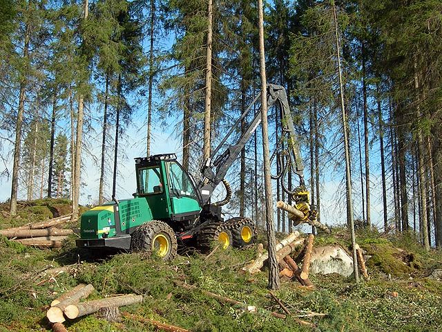
Connectivity: why it’s holding Forestry back
The problem with utilising smart industrial equipment is that it’s not that smart without a means of passing data between machines, people, or back-to-base. According to FPInnovations, 60% of forestry operations have no cellular coverage, which “prevents the timely flow of information between the forest and the data centre… we cannot use the productivity tracking technology that’s being used in other sections, such as agriculture.”
Cellular coverage in remote locations, especially covering woodland, mine pits or agricultural fields is often patchy or unavailable and this leaves remote teams and machines disconnected. Recent forestry development has overcome this, to some extent, using geostationary (GEO) satellite technology.
In their 2021 trial project, FPInnovations and partners tested the use of a mobile, private LTE (cellular) network in the forest. An LTE base station was set up at the edge of a cut block, utilising a 30-metre portable cell tower, omnidirectional antenna and tower-mounted amplifier (TMA) to increase signal strength for extended coverage. A satellite terminal was then used to connect the LTE system to the internet.
In this trial, one cell tower covered a 10-kilometre radius. Devices within this radius, including cell phones, tablets and telematics, communicated with the cell tower even while in motion. The GEO satellite service provided the essential backhaul of data. You can read more about the trial here, where the learnings from the project are available.
But this type of solution comes with high initial investment costs, and the use of geostationary satellites can create limitations over more rugged terrain, where a view of the sky is restricted. Devices that connect with geostationary satellites – in orbit 35,786 km above Earth – need to have a clear line of sight to their satellite, which can prove difficult in mountainous and wooded areas. The evolution of the project is to use a satellite transceiver that speaks to satellites in Low Earth Orbit (LEO).
The role of LEO satellites in bridging the gaps
Low Earth Orbit (LEO) satellite networks benefit from lower latency (because of their relative proximity to Earth), and can provide more reliable coverage if there are line-of-sight challenges, or the operation is mobile.
Iridium utilises a mesh of LEO satellites able to communicate with one another, passing data from one satellite to another, until the final destination is reached. Antennas communicating with the mesh network don’t need to be ‘pointed’ towards a single satellite, as data can be picked up by any satellite within the constellation and passed through the network, to the ground station.
This makes this network ideal for mobile IoT applications, and perfect for heavy machinery, or operations that shift in location, such as transitory logger camps. Iridium Certus 100 service can provide ubiquitous connectivity in very remote, forest areas.

Implications for developing precision forestry technologies
Reliable satellite connectivity, be that as the primary form of data connectivity or as a data backhaul for cellular or LoRa networks, creates the foundations for smart precision forestry technology, bringing several exciting digital operational capabilities.
The guaranteed connectivity is essential to the constant stream of data that passes between high-precision heavy machinery and the controller. It may be simple sensory data, such as sudden movements, or hazardous objects detected in the logging zone; a block in the workflow or a major mechanical malfunction. Remote heavy machine monitoring, diagnostics and troubleshooting can also provide advance warning on machine maintenance, saving downtime and redundancy, creating operational efficiency and reducing costs.
Steps towards Forestry digitisation
One obvious consideration for implementing precision forestry technology is the scale of investment relative to the size of the logger operation. For a forestry operation curious to see if the benefits of automation can be realised, satellite IoT devices present a very rapid and low cost means of backhauling data from individual machines, and can be rapidly scaled up or down. They can help logging operations evolve from analogue to digital in incremental ways, depending on the volume of data that needs to be transferred, and the critical nature of what’s being communicated back to base, or between man and machinery.
Automated machinery requires constant data connectivity for safety and autonomous decision-making, whereas maintenance alerts may only be necessary on a report-by-exception basis. For each use case, our technical team is able to advise on the best satellite service to support the operational needs and budget.
The RockREMOTE Rugged provides a fertile opportunity for trialling the benefits of satellite connectivity in a forestry setting. It’s aluminium cased, and built to withstand the roughest of environments. Fixed to a remote asset, like a Forester or Harvester, the device enables satellite data transfer of predictive and preventative maintenance analytics, for example.
Customers with small to moderate-sized Industrial IoT data requirements can utilise Iridium’s IMT message-based service for cost-effective data transfer. For more data-heavy applications and real-time monitoring, the device connects TCP/IP-related data, via the Iridium Certus 100 Airtime service. Certus 100 enables data transfer of up to 200 MB per month with speeds of 22 Kbps up and 88 Kbps down.
As mentioned earlier, it will maintain a reliable connection on the move, and transmit from anywhere with a clear view of the sky. If your devices and assets are already connected to an LTE Cat 1 or Cat 4 cellular network, the Rock Remote Rugged device also offers automatic WAN to satellite failover.
Digitising Forestry offers more opportunities for data insight and application: from advanced forest mapping, sensor-controlled environments and forest nurseries, to the use of drones/UAVs for fire monitoring and precision forestry inventory. Satellite provides the instant infrastructure needed to test and scale projects like these.
Unlock the potential of your data
If you would like help unlocking the potential of data for your next precision forestry project, get in touch. Our technical team would be happy to assist, no matter how big the project or whatever the question…
SmallSats, Big Impact, and the Future of Connectivity in Water and Waste Water Processing
Satellite IoT is exploding right now, with new entrants left, right and centre, and some huge names throwing their hats into the ring: Starlink for one, and Amazon’s Kuiper for another. This incredible proliferation of satellite network operators is driving innovation at an unprecedented speed, but there’s also a lot of hype. In this post, aimed at sensor manufacturers supporting the water and waste water industry, we’re going to explore what’s currently available, what’s coming soon, and what we think the next five to 10 years looks like – with some myth-busting along the way.
Satellite networks launched between 1965 and 2011
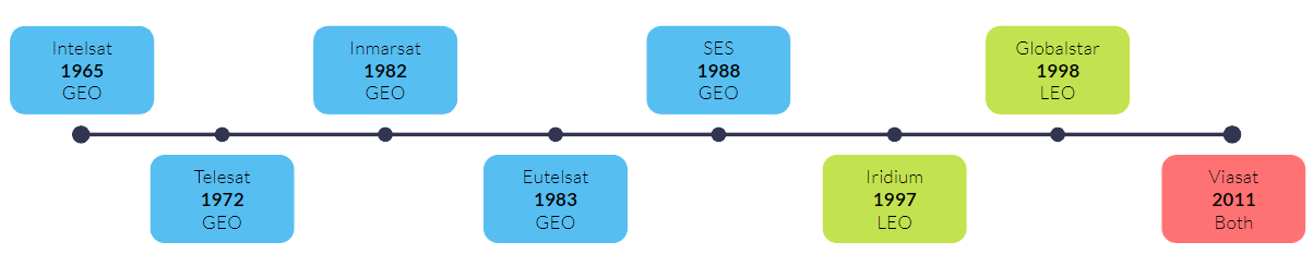
This timeline shows the launch dates of the “old guard” of satellite network operators; and while they’re unquestionably well established, don’t take old as meaning redundant here. These companies have stood the test of time; their services are highly reliable, and they’ve repeatedly updated their networks over the decades. Between them they serve the gamut of satellite internet applications, from Iridium’s Short Burst Data, designed for tiny amounts of IoT data, through to Viasat’s broadband internet service with speeds of up to 100 Mbps.
Satellite networks launched between 2018 and 2024
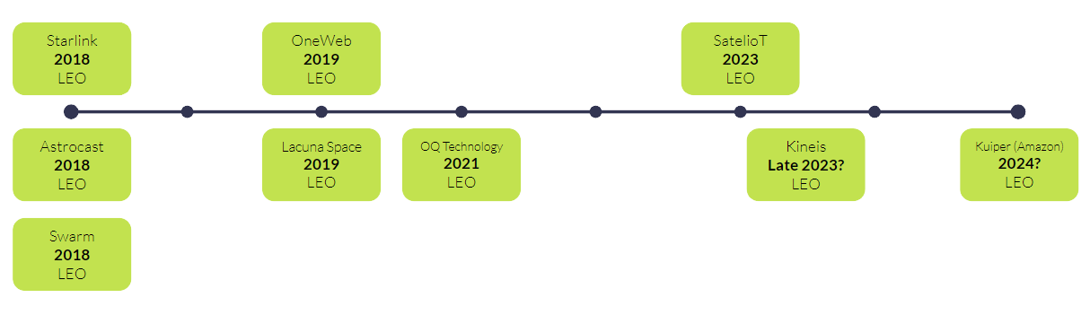
As mentioned, in recent years, more and more companies have started to build satellite networks; all are in Low Earth Orbit (LEO), and almost all are using what are called “SmallSats”. Here we’re using the term for any satellite weighing less than 180 kg and measuring between the size of a kitchen fridge and a Rubik’s cube. It’s this smaller size that has, in part, allowed for this growth – it’s much cheaper to put a SmallSat into Low Earth Orbit than it is to put a large satellite (over 1,000 kg) into Geostationary orbit.
Coupled with the trend for SmallSats and Low Earth Orbit, the other major reason for the increased number of new entrants is the lowered cost of putting satellites into space. From $85,000 per KG in the 1980s, to just $1,000 per KG in 2020 (source); for that you can largely thank SpaceX.
About satellite orbit heights
A quick explanation about the significance of orbit heights in satellite connectivity. Satellites in Low Earth Orbit (or LEO) are much closer to Earth than Geostationary satellites, which means that the time it takes to send data to the satellite and back to Earth is reduced – usually less than 1 second.
If you need real-time data transmission for your systems to operate smoothly, this is a welcome and necessary benefit. However, for this to be realized in practice, there needs to be a satellite overhead at the point at which you transmit; we’ll touch on the challenges new entrants have in this respect shortly.
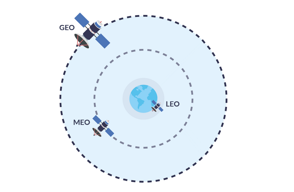
What are the implications for water sensor manufacturers?
1. Lower cost
Firstly, cost: these networks cost less to establish, so the operators have less costs to recoup! That in turn has forced the established players to diversify their services to compete. This is great news as the relatively high cost of sending data over satellite previously made some use cases non-viable – but no longer. If you need to capture data from your remotely deployed sensors, cost is rarely, if ever, a prohibiting factor now.

Reservoirs
Water levels, precipitation, air and water temperature, relative humidity

Pipelines
Leak detection, Third Party Intrusion, broken wires, storm water ingress

Treatment Plants
Water levels and flows, energy consumption, water quality, equipment status
2. Smaller antenna size
Secondly, antenna size and power. This has always been variable depending on the amount of data needing to be transmitted: a large amount needs a large antenna and a decent amount of power. Small amounts of sensor data, however, can be sent to satellites in Low Earth Orbit using absolutely tiny antennas such as the patch antenna included with the RockBLOCK 9603.
This connects to the Iridium network, which was one of the first LEO networks launched. This low-power-by-design modem can be powered by a battery for many years, and the same is true for many of the devices which connect to the new space entrants.
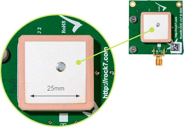
3. The convergence of satellite and 5G
The next step in the evolution of Satellite IoT is the convergence of cellular and satellite networks. The telecommunications industry is working on several ideas that will enable seamless data transfer between these networks. A key application of this convergence is to extend the reach of 5G which in comparison to its predecessors, provides limited coverage. If satellites can function as “cell towers” in space, it would unlock the full potential of 5G, providing global coverage from anywhere on the planet. 3GPP’s latest release – Release 17 – included technical specifications for direct-to-device 5G over satellite. This release also extended interoperability, Integrated Access and Backhaul (IAB), and network slicing to support Non-Terrestrial Networks (NTNs). Read more about 5G and satellite technology.
Things to be aware of
It’s not all good news, though. It takes time and money to build a reliable satellite constellation, and every one of the new entrants is still in the process of establishing their network – including Starlink and Swarm.
That means that you can suffer from high latency – i.e. there simply isn’t a satellite overhead for your device to send data to, so you will need to wait until there is. To give you a real-life example, if you connect your sensor to the Swarm network from North America, it can take from 2 minutes to 2 hours for your data to be intercepted by a satellite, and then delivered back to Earth. For Iridium, those parameters are 10 seconds to 15 minutes. And bear in mind Swarm (acquired by SpaceX in 2021) is one of the best established of the new entrants; newer and less well funded companies will have much longer delays.
Similarly coverage can be spotty; there is still only one satellite company that delivers 100% global coverage, and that’s Iridium. The established geostationary satellite operators usually have great coverage, and just miss out the polar regions.
The new networks also suffer from congestion: demand can outstrip supply, leading to failed transmissions and higher costs as data packets are re-sent; plus slower speeds when the network is busy. That’s plaguing Starlink right now – they’ll fix it, for sure, but just now it could be problematic.
However, if your instruments or sensors are within the coverage of one of these networks, and you can cope with receiving data once or twice a day, with the promise that this will speed up as they launch more satellites, then there is a huge amount of choice available to you, and the cost is really very low.
Our recommendations for water sensor satellite connectivity
For critical national infrastructure like water utilities, we continue to recommend established networks like Eutelsat, Iridium and Viasat with millions of subscribers, who’ve proven they can manage spikes in demand; who’ve got redundancy services baked in; who have very high levels of coverage and still benefit from very low latency.
What about data security?
“Water utilities are the third most targeted sector for hackers in the United States”
– Journal of Environmental Engineering
Water terrorism is on the rise and is likely to get worse as clean, safe water becomes an increasingly scarce resource. In 2022, hackers claimed to have access to the SCADA data of Thames Water (oddly, while they thought they’d hacked Thames Water, they’d actually hacked South Staffordshire Water; and in neither case were they actually able to access SCADA systems).
The hackers claimed to have the ability to tamper with the safety of drinking water, a terrifying prospect for the general public (source). While this incident blew over with basically no harm done, there are state-sponsored cyber warfare units who will be vastly more capable, should they be tasked with targeting national infrastructure.
To be clear, sending your data via satellite isn’t risk-free. But it is much harder to intercept data going from a sensor to a satellite, then back to a ground station, than it is to intercept data that’s using public infrastructure like the internet. And if that ground station is physically on your premises – that’s an air-gapped solution that’s about as secure as data transfer gets. This private satellite network is called TSAT and we don’t know of any more secure way to transmit mission critical data.
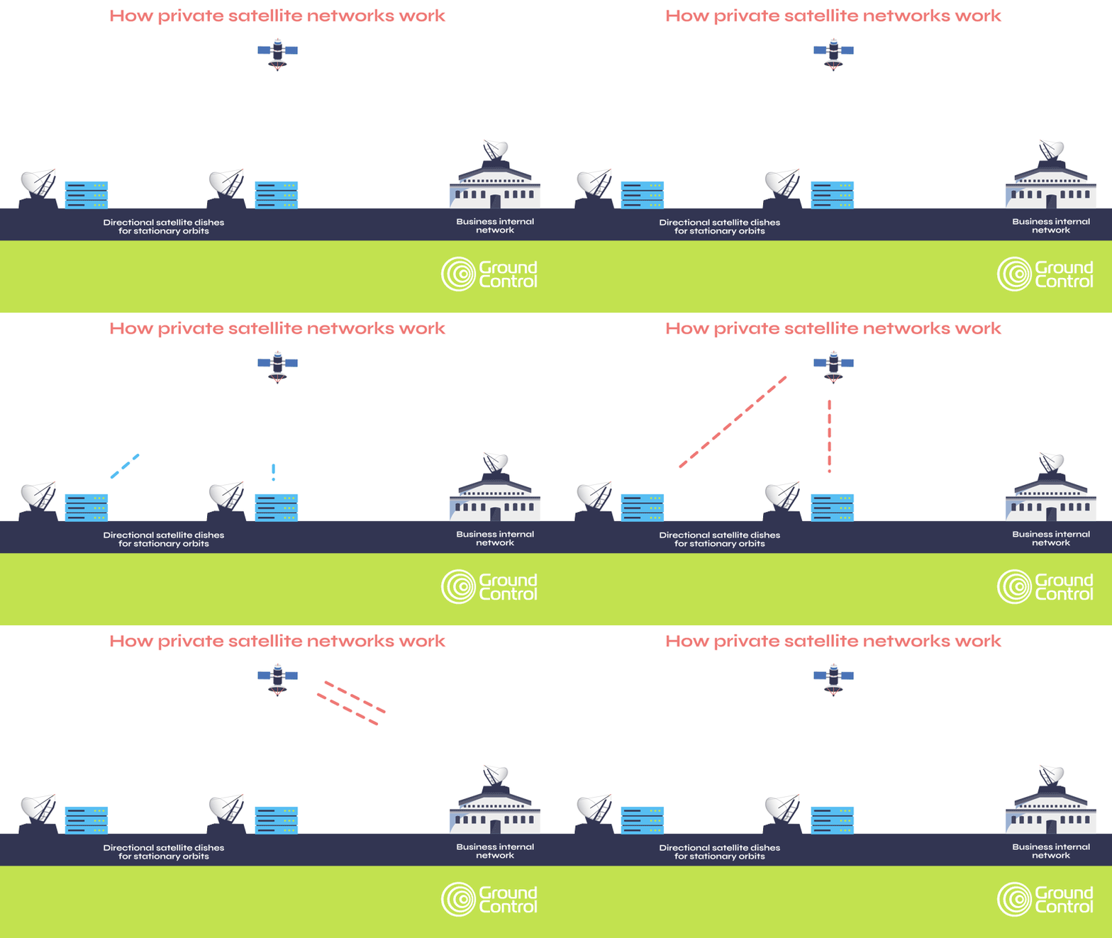
And while TSAT represents the highest tier of security capabilities within satellite IoT, by default, satellite data traffic is relatively secure, meeting most military and government security standards.
Further, at Ground Control, we’ve built Cloudloop, a delivery network for Iridium and Viasat traffic, which allows us to have full control over our certified, cutting-edge data paths, while securely delivering traffic.
We built this because we wanted to deliver additional security for our customers’ data, and offer optional public static IPs and completely configurable firewalls to assist in securely moving your data from A to B.
To summarize: satellite IoT has transformed in the last five years: prices have come down, transceivers are smaller, power requirements have lessened, and security has improved. And with Amazon’s Kuiper satellite network scheduled for launch in 2024, the pace of change is not going to slow.
We’re here to help you make sense of all of this. We keep on top of all of these developments so we can make expert recommendations to you, and ensure that a system you implement today will remain viable 5, 10 or 15 years into the future.
Would you like to know more?
We partner with sensor / instrumentation manufacturers to deliver end to end solutions for water companies across the world. If you design and build sensors, we’d love to hear from you to talk about working together. If you’re a water utilities company and looking for a connectivity bridge for your remote sites, we can help!
Call or email us, or complete the online form, and we’ll come back to you within one working day.
Communicating effectively during major incidents: 3 challenges facing first responders
Did you know that 81% of emergency managers have experienced communication failures during emergencies?
Whether a major incident is caused by a natural disaster, accident or malicious intent, first responders have to contend with a constantly evolving situation where priorities can change from minute to minute. Adding to the complexity is communication, which is made particularly challenging when multiple agencies need to communicate in order to respond effectively; when an incident takes place in a remote area, or if bandwidth gets constrained.
None of these issues are easy to resolve, but we’ve written this blog post to outline some potentially overlooked, affordable and easy-to-deploy solutions which can help tackle the three core issues of interoperability, network congestion, and coverage in remote areas.
1. Interoperability
“During incidents like 9/11 and Hurricane Katrina, cell phone towers were destroyed and overloaded, and first responders’ radios were incompatible, making life-saving communications almost nonexistent when they were needed most.” – United States Army
“The inability of responders from different departments and jurisdictions to communicate over their various radio systems during the event… was determined to have been a factor in the inability to evacuate 343 firefighters from the World Trade Center buildings, who all perished as a result.” – Dereck Orr, NIST
Why were the radios incompatible? Because public safety departments across the US are free to choose their own radio systems from different manufacturers, which sometimes operate on different radio bands. But forced standardization of radio systems isn’t the answer, as allowing agencies to select their providers encourages competition, driving innovation and lowering costs.
Two options present themselves: firstly, using an “interoperability gateway” otherwise known as a crossband repeater – technology designed to transmit and receive on different parts of the radio spectrum. These devices can be quickly deployed to allow agencies using different radio systems to talk to each other, in addition to other frequently used devices like satellite phones and VoIP desk phones.
Secondly, using Mission-Critical Push-to-Talk (MCPTT) enabled devices. This is a newly developed protocol that several telecommunication companies are building into their applications, including Ericsson, Qualcomm, ESChat and Motorola. If you’re using software built to the MCPTT specification, irrespective of the network or handset being used, you can communicate with other agencies using MCPTT. Currently this technology isn’t interoperable with LMR, but this is a known requirement that’s being worked on (source).
2. Network congestion
For people caught up in an emergency, it’s a natural reaction to try and reach friends and family, but this can, and frequently does, lead to network congestion. And that can have catastrophic consequences for emergency responders and the people they’re trying to save.
Cognizant of this, two communications companies took the initiative to create networks exclusively for the use of first responders: AT&T’s FirstNet, and Verizon’s Frontline. Both provide a choice of different phones, tablets, laptops and routers compatible with the service, and cover up to 2.71 million square miles. This helpful article provides a more detailed comparison and pricing.
It’s not a perfect solution: users of FirstNet have reported poor signal coverage, while users of Frontline report frustration with saturated networks. One workaround is to use an app like ESChat, which supports multiple terrestrial networks, but also offers a satellite option, Iridium Certus, which provides 100% global coverage. That’s a highly valuable failsafe if cell phone towers are damaged or congested, or terrestrial infrastructure is wilfully targeted, as was seen at the Nashville bombing in 2020.
ESChat partnered with Thales to make this satellite solution available. If you’re a first responder with a MissionLINK 200, MissionLINK 700 or MCD-MissionLINK device, or its maritime equivalent, the VesseLINK 200 or VesseLINK 700 (the differences are the data speeds available), you’ll be able to subscribe to the ESChat service and benefit from low-latency PTT from your smartphone or tablet.
Satellite systems in general are a great failsafe should terrestrial networks be damaged, destroyed or overloaded; and the proliferation of new satellite constellations over the last few years has created more choice and lower prices for users.
Do satellite networks suffer from network congestion too?
As satellite grows in popularity thanks to companies like Starlink, congestion on satellite networks needs to be considered. Like terrestrial networks, some satellite network operators provide dedicated bandwidth for emergency response traffic, whereas with others, you’re sharing the network with commercial users. Starlink for example has grown its user base so quickly that the demand is outpacing the capacity of the network, causing speeds to slow right down when many customers try to connect at the same time.
The best advice is to do your research, and ideally speak to someone who understands the satellite industry very well before deciding on a satellite partner.
3. Coverage in remote areas
While FirstNet and Frontline cover 77% of the landmass of the United States, that still leaves 800,000 square miles where there is no cellular coverage. These dead zones are naturally removed from population centers but are no less at risk from wildfires, hurricanes, earthquakes, landslides or flooding, which can cause huge damage to critical infrastructure like oil, gas and water utilities, plus farms, forestry and mining operations.
Sending emergency responders into areas like this presents a new set of challenges around communication, as neither cellular nor radio networks are likely to be consistently available. Satellite systems perform highly effectively in these circumstances, providing instant infrastructure that’s independent of terrestrial networks.
Portable, battery-operated devices like the MCD-4800 “The Football” or the MCD-MissionLINK create a WiFi hotspot of up to 1,000ft, providing broadband internet for up to 12 connected devices.
This delivers reliable access to email, text messages, Material Safety Data Sheets (MSDS), and mapping. It enables the tracking of manpower and equipment, and access to GIS data; as well as the ability to upload drone data and to monitor local TV news coverage.
Even a simple handheld device like the RockSTAR can save lives. This highly ruggedized equipment provides real-time tracking of your personnel, and can transmit IoT data such as their temperature and heart-rate.
Two-way text messaging is possible both via the device and via a Bluetooth-connected smartphone, and there are alert features if the device is dropped, or the person moves out of a pre-agreed trajectory.
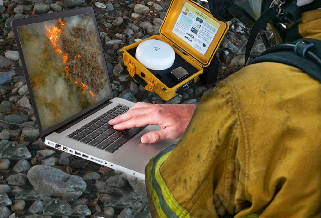
Effective communication during major incidents is a tough nut to crack, but the technology exists today to overcome interoperability challenges, and the emerging MCPTT protocol holds great promise to banish this issue altogether. But it remains important to have options, like satellite, that don’t rely on terrestrial infrastructure. Terrestrial infrastructure – including that which supports LMR – will always be the default, but that makes it a high priority target for terrorist attacks. Plus, it remains vulnerable to natural disasters, and is absent from 23% of the US’ landmass.
Objective, expert advice
Ground Control is a satellite communications expert, having supplied emergency responders with solutions for over 20 years.
We work with multiple satellite network operators and partner with companies like Thales, Hughes, Cobham and Starlink to make sure you get the best possible solution for your circumstances. We’re here to help with objective, expert advice when you need it.