Coverage is a key consideration when choosing a satellite network for your application. At its most basic level, you need to ensure that the network you choose has orbiting satellites that cover the area from which you need to transmit data. This is widely available information – our Calculators and Maps page provides coverage maps for many of the main service providers.
However, being able to provide coverage on paper is not the same as being able to do so in practice. Because you also need to ensure that your terminal’s antenna can easily communicate with the satellite. In order to do so it needs to be able to ‘see’ the satellite clearly. Depending on the type of satellite you’re connecting to, this is often referred to as as a requirement for ‘line of sight’ or a ‘clear view of the sky’.
Geostationary satellites (e.g. Viasat) require a ‘clear line of sight’
Geostationary satellites are positioned 35,786 km above Earth and are travelling at the same speed as Earth’s rotation – hence why they appear stationary, and the reason for the name. If your satellite antenna is designed to communicate with a geostationary satellite, it must be able to ‘see’ it. Many devices will help you figure out how well aligned your antenna is with the satellite (called the ‘look angle’) with a series of LED indicators or sounds. Once you’ve appropriately located your antenna, as long as it doesn’t move, it will retain a very stable connection with the geostationary satellite.
Low Earth Orbit satellites (e.g. Iridium) require a 'clear view of the sky'
Iridium has 66 satellites orbiting Earth at 780 km up, and they’re travelling at 30,000 km per hour. It will take a single Iridium satellite about seven minutes to pass from horizon to horizon, and in most places / at most times, there are two or three passing overhead. This confers a great benefit on users as antennae do not need to be ‘pointed’; they are omni-directional, meaning that they can transmit data at virtually any angle and – as long as there are no obstacles – one of the passing satellites will ‘pick’ the data up.
However, if your device doesn’t have a clear view of the sky from horizon to horizon, there will be points in the satellite’s trajectory where it can’t receive a signal. For example, if you have a hydrology station collecting water quality data, in one direction it might face the dam wall; in another it might have a clear and unobstructed view of the horizon.
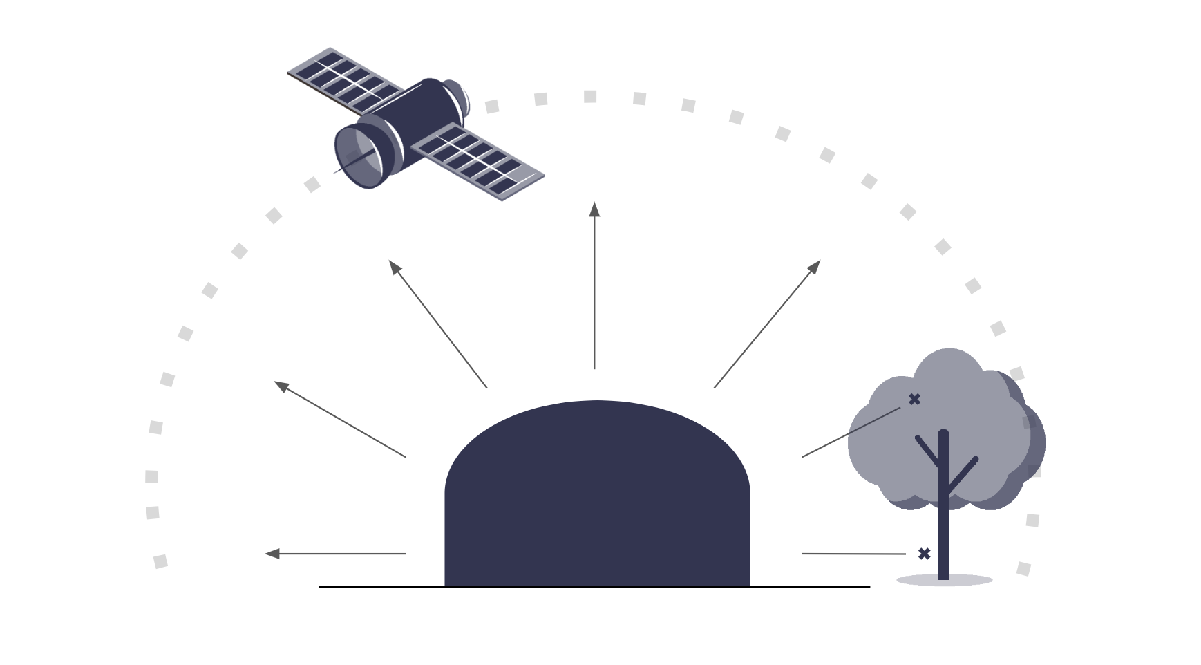
In this instance, the Iridium satellite is able to receive data when it’s sufficiently overhead so that the dam wall isn’t blocking the signal, and it will continue to do so until it drops out of sight. This means you’ll get close to real-time data for approximately five out of the seven minutes during which the satellite is passing overhead.
What can prevent a clear view of the sky?
Typical obstructions include tall buildings (urban landscapes), dense foliage (trees, forests), and natural terrain features like mountains or valleys. Each of these reduce your ‘view of the sky’ and the effectiveness of satellite connections.
What’s the impact of an impaired view of the sky?
There’s likely to be an impact on signal quality and consistency: obstructions can completely block data packets (e.g. Iridium’s Short Burst Data service) and can affect the quality and consistency of connections that require a stable connection (e.g. IP connections such as Iridium Certus).
Ultimately this can lead to reduced accuracy and reliability of satellite based tracking/communication equipment.
How can you tell if you truly have a clear view of the sky?
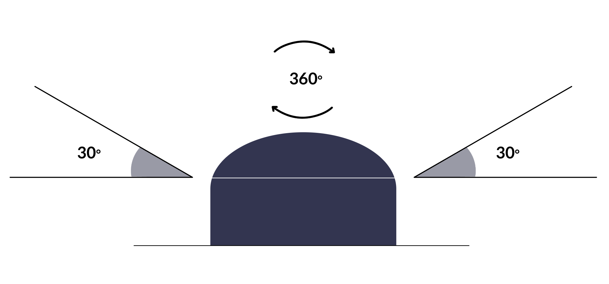
It may sound silly, but our engineers recommend this process as it gives a better understanding of ‘clear view of the sky’ from a satellite device’s perspective.
- Position Your Arms: Stand outside in the location where you use the device. Extend your arms in front of you, with one hand placed directly on top of the other.
- Create the ‘Crocodile Mouth’: Keeping your arms extended, separate your hands by raising one arm upwards, while keeping the other arm steady. The angle between your arms should be approximately 30 degrees. This creates a shape resembling a crocodile’s open mouth.
- 360-Degree Turn: Slowly turn your whole body in a full circle, 360 degrees, while keeping your arms in the same position.
- Observe the Sky View: As you turn, look through the gap between your hands (the ‘crocodile mouth’). You need to check if there are any obstructions in this view. These obstructions could be anything that breaks the line of sight between your hands and the sky, like buildings, trees, or other tall structures.
- Evaluate the View: If at any point during your 360-degree turn you see obstructions between your hands, it indicates that you don’t have a clear view of the sky. The aim is to have an unobstructed view of the sky throughout your entire turn, ensuring that the device can communicate effectively with the overhead satellites.
What to do if you don’t have a clear view of the sky
If your application can manage without 100% real-time data, then having a compromised view of the horizon may not be an impediment. You’ll get your data very frequently, assuming that there is at least some sky visible to the antenna!
If you don’t want to compromise, most engineers will try to elevate your antenna so that it clears the current obstructions. Mounting it on a pole is a very common option.
In extreme cases, something like LoRaWAN can be used to transmit the data from the bottom of a canyon, for example, up to a more open location where a satellite transceiver can do its job.
You could also explore a different satellite network: it’s possible that a geostationary satellite might be at just the right look angle for your antenna, and once these are locked in, they’re extremely stable.

Talk to the experts
We’ve implemented satellite IoT infrastructure for decades, and there’s very rarely been an obstruction issue we couldn’t overcome with a bit of knowledge and ingenuity.
We’d be happy to talk to you about your project and offer impartial advice on the best antenna and satellite service for your particular requirements. Call or email us, or complete the form.