The UK’s National Oceanography Centre (NOC) is one of the world’s top ocean research institutions. NOC’s scientists work around the globe, uncovering links between the ocean, climate change and biodiversity loss, to help every living thing on our planet flourish.
The organisation solves challenging multidisciplinary, large scale, long-term marine science problems to underpin international and UK public policy, business and societal outcomes. NOC also operates the Royal Research Ships James Cook and Discovery and develops technology for coastal and deep ocean research.
About the Project
In the Western Indian Ocean’s Pemba Channel, monsoon seasons shape life above and below the surface. Understanding where currents accelerate, where eddies form, and how waters connect across borders is essential to safeguarding fisheries, supporting livelihoods, and protecting biodiversity. NOC led collaborative work within SOLSTICE-WIO to generate that evidence, while building local capacity so the benefits endure.
The Connectivity Challenge
The Pemba Channel is remote, energetic, and sparsely instrumented. Cellular coverage is unreliable; the science window is short. NOC needed a way to capture near-real time trajectories from small, battery powered drifters during the monsoon; robust enough for rough seas, simple enough to replicate, and affordable so partners could scale it into routine observing. The goal was decision-ready data to inform sustainable fisheries and coastal planning.
The Solution
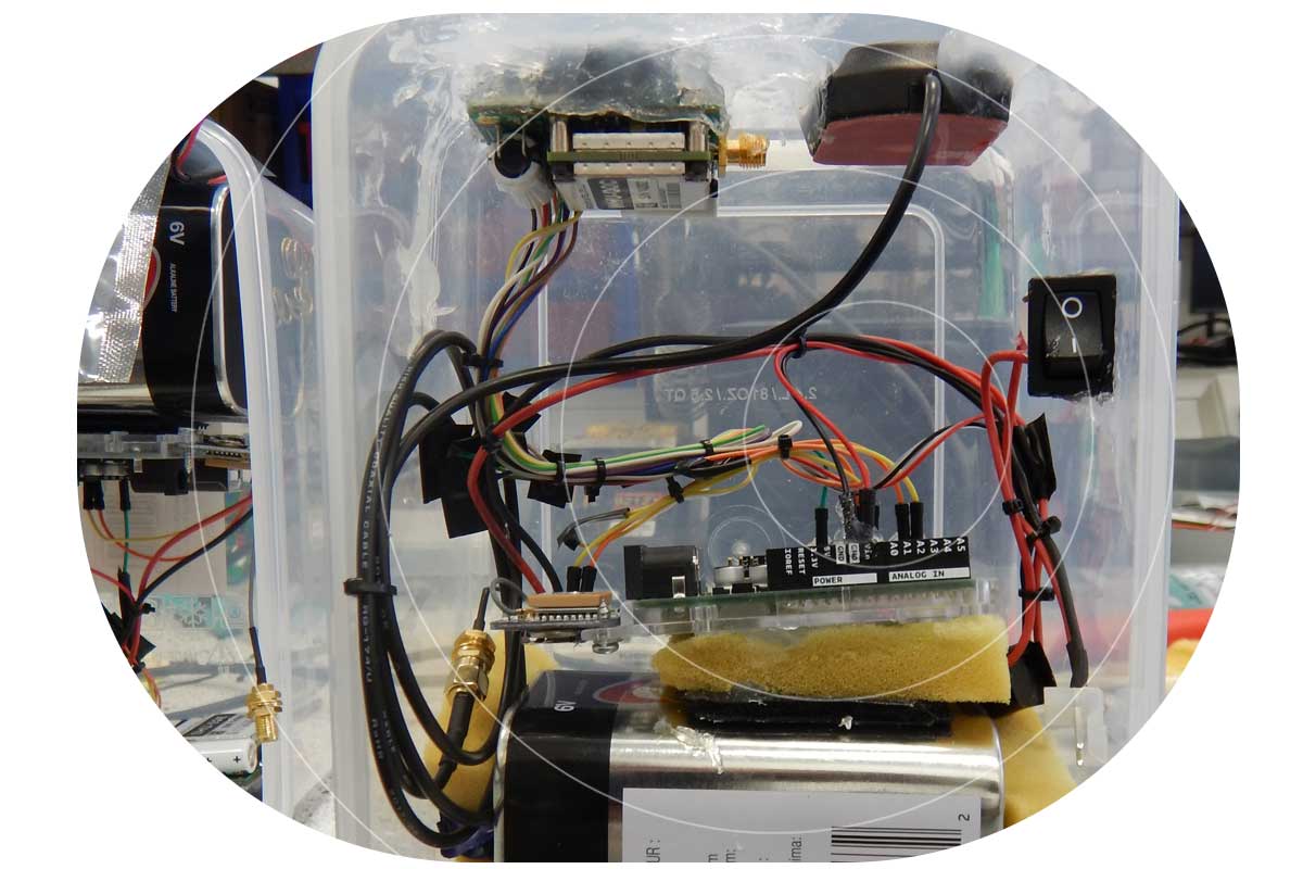
To achieve global connectivity from compact platforms, NOC integrated Ground Control’s RockBLOCK 9603 with Iridium Short Burst Data. The 9603’s small footprint, straightforward wiring, and low power draw made it a natural fit for locally built, low cost drifters assembled from off the shelf parts.
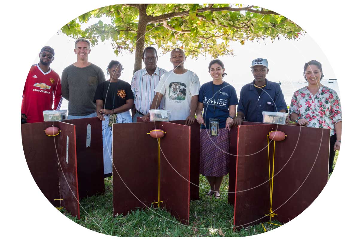
NOC and partners constructed a fleet of nine surface drifters and executed multiple deployments across tidal cycles and shifting winds. Each unit uplinked GPS positions via Iridium, feeding a simple tracking and visualisation workflow so the team, and regional stakeholders, could see the ocean move as conditions evolved.
Why RockBLOCK 9603 for Metocean Data?
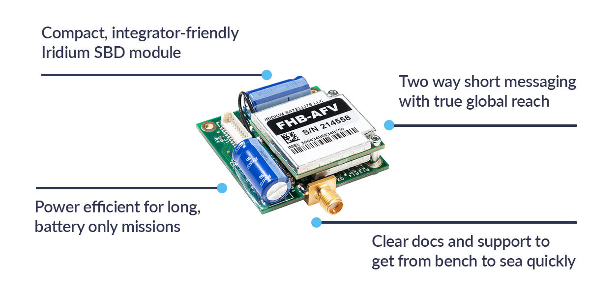
RockBLOCK 9603 delivers global, two way Iridium Short Burst Data (SBD) messaging from compact, battery-powered platforms. It’s designed for harsh, remote environments where cellular networks aren’t an option, providing dependable links for position reports and sensor data whenever a clear sky view is available.
Integration is straightforward. The 9603’s small footprint (45×45×16 mm, ~39 g) and simple connector make it easy to embed alongside GPS and microcontrollers in space constrained builds. Clear developer documentation and example workflows help teams move quickly from bench testing to sea trials.
Power efficiency is a core advantage. Short wake cycles and low standby draw support long deployments on modest battery packs, which is ideal for lightweight drifters and autonomous systems. In practice, that means more time collecting decision ready data, and fewer retrievals or battery swaps.
The Results
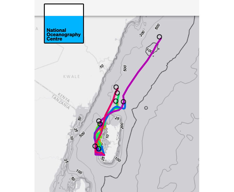
Actionable ocean intelligence: The drifters resolved fast central flows, persistent eddies, and strong tidal modulation. These features drive nutrient transport and productivity, shaping fish distribution and catch success. Turning them from invisible forces into mapped patterns helps align fishing effort with sustainability.
Connectivity across borders: Tracks that exited the channel highlighted time dependent links into Kenyan waters, informing conversations about shared stocks and coordinated management.
Capacity built in the region: Because the design is repeatable and affordable, partners can assemble, deploy, and interpret their own drifters, embedding skills locally, and creating a foundation for long term observation.
Better models, better policy: Observations serve as ground truth alongside remote sensing, strengthening regional ocean models that underpin fisheries advice, marine planning, and climate resilience strategies.
“RockBLOCK on Iridium gave us the combination we needed: reliable coverage, simple integration, and predictable costs. Without it, it would not have been possible to deploy our locally built drifters in the Western Indian Ocean’s Pemba Channel, a remote and poorly measured region.”
Dougal Lichtman, National Oceanography Centre
What’s Next
With risk removed and methods proven, NOC progressed to larger autonomous robotics campaigns and set a repeatable, seasonal blueprint for satellite linked drifter work in the Western Indian Ocean. The path forward is practical and scalable: more community-built instruments, standardized payloads, and shared dashboards, so evidence flows quickly into the hands of people making decisions for fisheries, habitats, and coastal resilience.

Have a Remote Monitoring Challenge?
Ground Control has over 20 years’ experience in connecting very remote things, from data buoys to weather stations, animal tracking collars to wind farms. If you have an application that’s out of reach of cellular, we can help you bring your data home.
Tell us about your project by completing the form or emailing hello@groundcontrol.com; we’ll reply within one working day with expert, impartial advice.