Every few years, a disruptive technology emerges quietly but ultimately reshapes entire sectors. Today, Assured Positioning, Navigation, and Timing (A-PNT) is gaining momentum, and Iridium’s Low Earth Orbit (LEO) PNT signal is one prominent space-based approach.
While most discussions around A-PNT focus on navigation, defense, or autonomous systems, one industry poised to benefit the most in financial significance is vessel insurance.
Shipowners and insurers face increasing pressure from unpredictable geopolitical risks, particularly in war-prone regions. The reliability of vessel position data has become a critical factor for insurers, who need to accurately assess risk in order to price policies and manage claims.
A-PNT technologies offer a solution to this long-standing challenge by providing trusted, tamper resistant, and independent positional data, which has the potential to transform how insurers evaluate and underwrite maritime risk.
The War Risk Insurance Market is Under Pressure
War risk insurance premiums have skyrocketed in the past two years, reflecting heightened threats in key shipping corridors and merchant vessels navigating unpredictable geopolitical environments.
These premiums, known as Additional War Risk Premiums (AWRPs), are applied on top of normal insurance cover whenever a vessel enters a high risk “Listed Area” defined by the London insurance market’s Joint War Committee (JWC). These surcharges can represent hundreds of thousands, and in some cases millions, of dollars per voyage, dramatically increasing operational costs for carriers.
One example is the Red Sea crisis caused by Houthi attacks in late 2023 and 2024. During this period, war risk premiums for a typical seven day transit of the Red Sea and Bab al-Mandab Strait surged from a nominal 0.05 percent to between 0.4 and 1.0 percent of the vessel’s hull and machinery value.
For a new high value container ship valued at approximately $150 million, this translates into an additional cost of roughly $665,000 per transit. Similarly, a Large Range 2 tanker valued at $105 million faces surcharges of around $420,000, while Very Large Crude Carriers (VLCCs) with insured values near $100 million could see premiums reach $1-2 million for a single high risk seven day transit. These extreme costs, combined with the actual risks of attack, forced major carriers such as Maersk and Hapag-Lloyd to reroute around the Cape of Good Hope, adding 10 to 14 days to their journey and significant fuel costs.
The Black Sea, affected by the Russia-Ukraine conflict, represents another hotspot where war risk insurance costs have surged. The conflict has had significant impact on the grain export corridor. After Russian strikes on foreign vessels, war risk premiums reportedly increased by approximately $125,000 per voyage for a $50 million vessel. In response, insurers collaborated with the United Nations to create specialized grain corridor insurance solutions, enabling essential exports to continue despite elevated risk.
While exact invoices remain private, publicly available market data shows that transiting a war risk area can add a substantial percentage of a vessel’s value to the cost of a short transit. Insurers desperately need reliable, tamper-proof positional data to assess risk, and ships need better protection from spoofing and GNSS interference. That’s where Iridium PNT becomes invaluable.
Where Iridium PNT Fits In
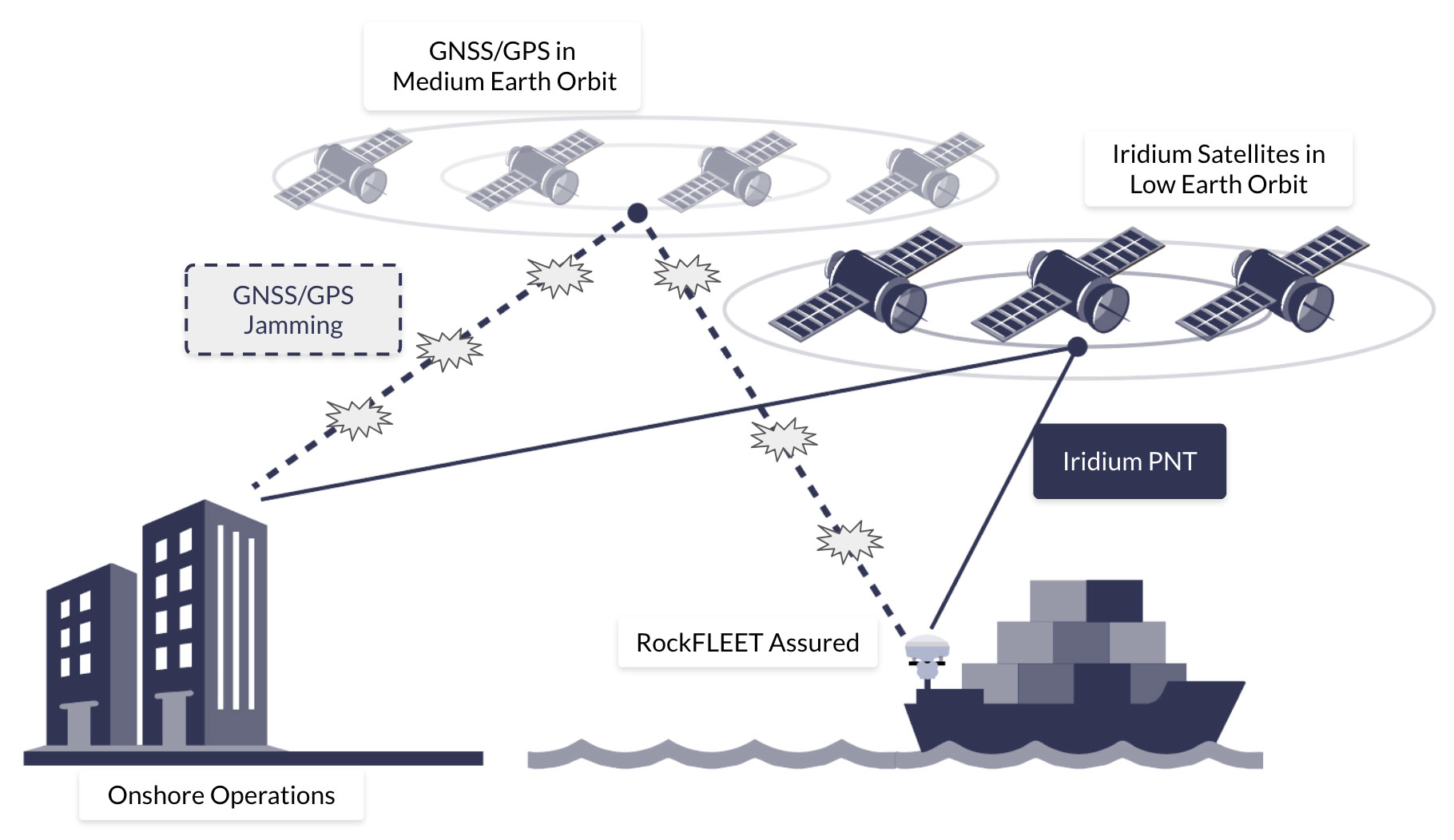
Current methods for tracking vessels include AIS (Automatic Identification System), radar, and GNSS-based location tracking. However, each of these systems has limitations. AIS data can be spoofed, turned off, or manipulated. GNSS signals are vulnerable to jamming or spoofing, especially in conflict zones, and radar coverage is generally limited to coastal regions, leaving open ocean transits less secure. These limitations create blind spots between reported and actual vessel positions, increasing both operational and financial risk.
Iridium PNT addresses these challenges directly. By leveraging the global coverage of Iridium’s Low Earth Orbit (LEO) satellite constellation, Iridium PNT’s broadcast signal is up to 1,000 times stronger than GPS and transmitted from satellites 25 times closer to Earth. This makes it far more resilient to interference and reliable even when GNSS becomes unavailable.
Why Merchant Shipping Needs A-PNT
The modern maritime industry operates under increasing levels of risk and uncertainty. War risk premiums are fluctuating dramatically, GNSS vulnerabilities are increasing, and traditional tracking solutions leave critical blind spots. In a world where a single transit can cost $500k to $2 million in extra insurance, any technology that enhances trust and reduces risk has immediate economic value.
For shipowners, A-PNT is more than a navigation enhancement. The technology is a financial and operational safeguard, enabling vessels to demonstrate the integrity of their movements and providing insurers with verifiable data that can reduce positional uncertainty. This can translate directly into lower war risk premiums as carriers can prove their routes and positions without ambiguity. By offering immutable, timestamped movement logs that are resistant to spoofing or tampering, A-PNT enables maritime insurers to price risk with confidence and operators avoid unnecessary disputes.
Beyond insurance savings, A-PNT also enhances safety and operational resilience. In high-threat areas, accurate, verified location and timing information is essential for navigation, route optimization, and compliance with safety regulations. Fleet operations centers can maintain situational awareness, even under GNSS interference, while captains receive reliable guidance via A-PNT to avoid hazards or restricted zones. The combination of operational safety and financial prudence positions A-PNT as an essential tool for modern merchant shipping. Ultimately, if ships can prove their track, timing, and location with high integrity – independently of GNSS spoofing and jamming – insurers can price risk with confidence.
Bringing Iridium PNT to the Bridge with RockFLEET Assured
RockFLEET Assured harnesses Iridium’s PNT service into a rugged, compact maritime solution built for real-world navigational pressures. It provides an independent source of positioning and timing when GPS/GNSS is jammed, degraded, or spoofed. Rather than relying solely on open GNSS signals, RockFLEET Assured can output A-PNT-derived position/time in standard NMEA format and includes configurable integrity and time difference checks to help detect anomalous conditions, supporting operations based on more reliable information when GNSS can’t be trusted.
The combination of its resilient architecture and practical engineering makes RockFLEET Assured a strong choice for vessels facing GPS-denied conditions and AWRPs. Cargo ships transiting spoofing hotspots can maintain position awareness even when GNSS becomes unreliable, helping bridge teams maintain safe routing. Naval vessels operating amid electronic warfare retain dependable timing and navigation essential for mission coordination. And unmanned surface vessels benefit from uninterrupted PNT in high latitude regions where GNSS performance can be challenged.
By combining Iridium’s PNT service with RockFLEET Assured’s maritime-ready integration and onboard monitoring features, RockFLEET Assured provides a trusted positioning capability to mitigate the threats that contribute to rising war risk premiums in regions like the Red Sea and Black Sea.
Reliable Navigation for Insurers and Shipowners
With millions at stake in AWRPs alone, Iridium PNT provides a new level of assurance for both insurers and vessel operators. For insurers, the technology reduces exposure to spoofing, improves positioning reliability, and enables more accurate data driven risk pricing. For shipowners and operators, APNT can lower war risk premiums, improve compliance, enhance safety, and ensure operational continuity in high-risk zones.
As the geopolitical risks continue to grow and GNSS vulnerabilities become more frequent, A-PNT is emerging not only as a navigation tool but as a business-critical tracking asset. It allows maritime stakeholders to operate with confidence, knowing that the positional data underpinning insurance decisions, operational planning, and safety compliance is reliable.
In this context, Iridium PNT and RockFLEET Assured represent a transformative solution, providing trusted, validated, and resilient positioning, navigation and timing data that benefits insurers, shipowners, and the broader shipping ecosystem. For stakeholders aiming to reduce financial exposure, enhance safety, and navigate conflict zones with confidence, RockBLOCK APNT is a reliable solution. By enabling a verifiable “source of truth” for vessel positioning, RockFLEET Assured enables more accurate, reliable and cost-effective maritime war risk insurance assessment for modern maritime operations.

Trusted A-PNT Expertise for Resilient Maritime Operations
Ground Control brings more than 20 years of experience delivering resilient satellite solutions for maritime and critical communications. We understand that no two vessels, fleets, or operating environments are the same, which is why we provide expert guidance on deploying the right mix of A-PNT capabilities and reliable satellite connectivity options to ensure trusted positioning, navigation, and timing at sea.
Complete the form, or email hello@groundcontrol.com and we’ll reply within one working day.