beadedstream provides real time monitoring systems for ground, structural, and environmental conditions in remote, time sensitive environments. On Alaska’s North Slope, its Ice Road Monitoring Stations help operators track subsurface tundra temperatures remotely, so they can make better informed decisions about when to begin ice road construction and mobilize equipment.
The systems combine field-installed temperature cables, data loggers, satellite telemetry, and beadedcloud access to give project teams site-specific visibility of changing ground conditions. Instead of relying only on broad opening dates or repeated manual checks, operators can use real time data to plan around actual conditions along the route.
The challenge
Each winter, ice roads are built across Alaska’s North Slope to access remote drill pads and move heavy equipment. Some routes can extend up to 200 miles, and operators must wait until the active layer of permafrost is frozen sufficiently before construction can begin.
Timing matters. If construction begins too early, the tundra can be damaged. If teams wait too long, they lose valuable operating days in an already short winter season.
That creates a difficult planning problem. Air temperatures may be well below freezing, but subsurface conditions can take another one to two months to reach the required threshold. At the same time, the winter operating season has shortened from about 180 days to roughly 120 days, leaving a much narrower window to build roads, mobilize drilling equipment, complete work, and demobilize before thaw.
For operators, the key question is whether the ground beneath the road route has reached the required temperature at the required depth. That information needs to be accurate, site-specific, and available without sending teams back into the field for repeated checks.
The solution
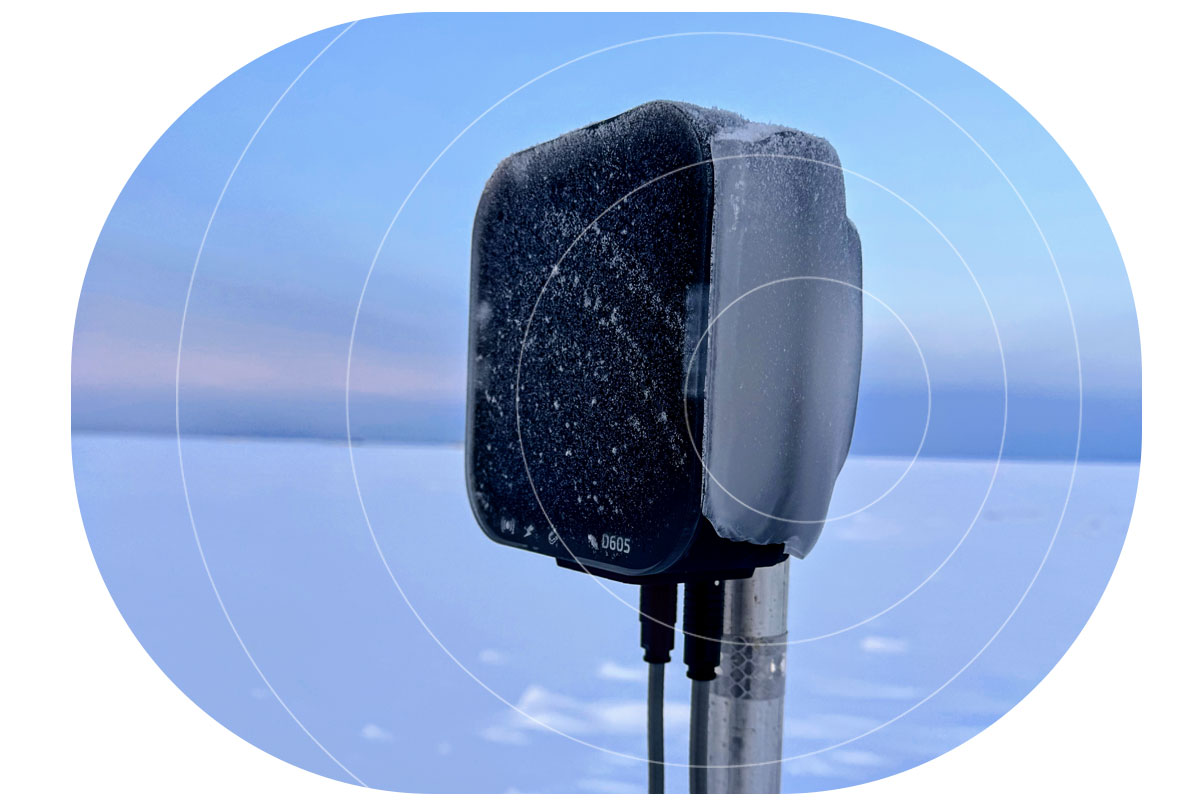
beadedstream addresses that challenge with distributed Ice Road Monitoring Stations installed along the route, typically at intervals of about every five miles. Station locations are chosen to represent different terrain and soil conditions, with greater concentration near the start of the road where construction begins first.
Each station includes a data logger and two Ice Road Temperature Cables: one installed along the road centerline and one control cable offset from the road. Each cable measures ground temperature at multiple depths, helping operators understand how freezing conditions are progressing below the surface.
The equipment is installed before freeze-up and remains in place through the winter operating season. Once deployed, the system collects temperature data automatically and transmits it remotely, allowing project teams to track changing conditions without relying on repeated manual site visits.
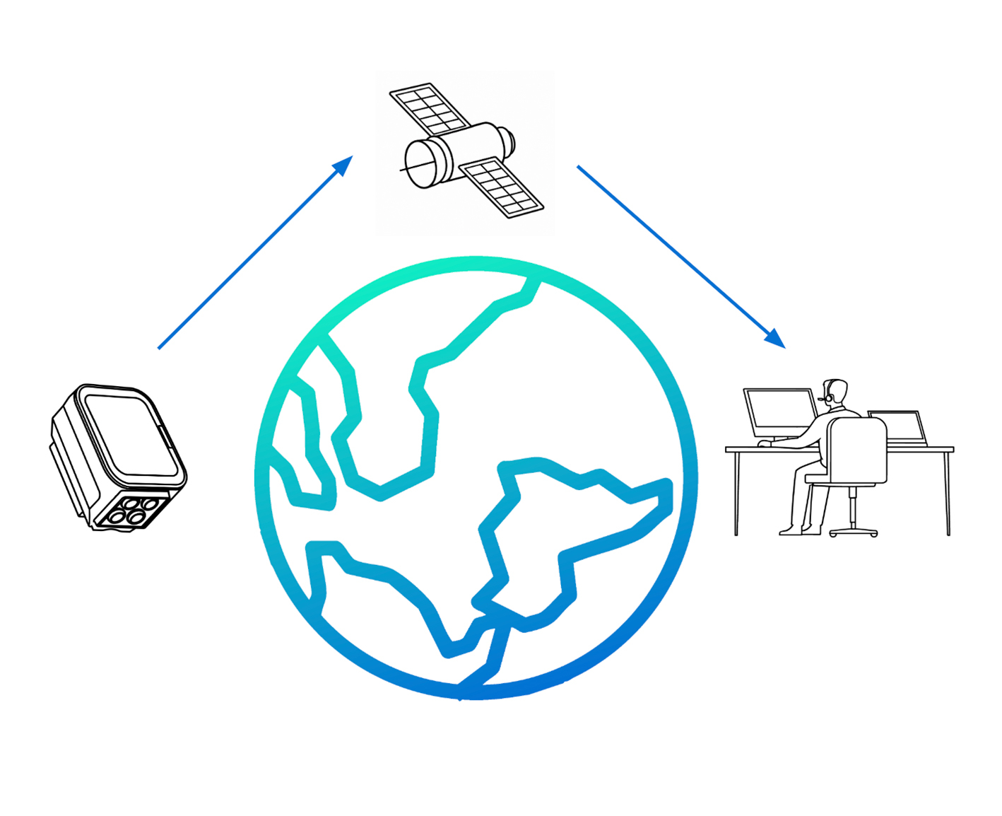
This system level approach is what makes the data useful. The cables collect ground temperature readings, the logger gathers the data, satellite telemetry moves the data from the field, and beadedcloud gives operators and stakeholders access to the information they need to plan and coordinate.
The connectivity layer
Reliable connectivity is critical for monitoring stations installed across remote tundra, often spread over long distances and difficult to access once winter conditions set in. Operators need data to come back consistently without repeated site visits.
beadedstream relies on Ground Control to supply the hardware and airtime services that connect its remote monitoring systems to Iridium’s global satellite network. This supports reliable data backhaul from field sites where terrestrial connectivity isn’t available.
Ground Control’s Cloudloop Subscription Manager also helps beadedstream manage connectivity across deployments, with visibility of usage and billing data and the ability to activate, deactivate, suspend, and monitor subscriptions in real time.
In this application, satellite IoT connectivity is the link that makes the full remote monitoring system practical.
Earlier visibility, earlier action
Using beadedcloud, operators can monitor tundra temperatures in real time and forecast when the ground will reach 23°F (-5°C) at 1 ft (0.3 m) depth, a key benchmark for access permitting. Operators can predict that date to within about one day, while one customer reports accuracy within 6–7 hours.
That gives teams time to act. Around a week before the forecasted opening point, they can begin mobilizing equipment and start discussions with Alaska DNR around access permits. Data and forecasts can also be shared through beadedcloud, improving coordination between operators, regulators, and field teams.
The result is a more informed operating window. Real time monitoring has helped operators access the tundra up to 1 to 1.5 months sooner than general opening dates. It also reduces unnecessary site visits, improves planning, and lowers safety exposure and cost by cutting down on manual checks.
“Reliable remote connectivity is what makes real-time monitoring possible in environments like this. Providers like Ground Control play an important role in enabling that, particularly in remote applications where consistent data access is critical.”
– Brian Shumaker, CEO & Founder, beadedstream
Looking ahead
beadedstream is continuing to expand how remote monitoring data is used, particularly around forecasting and predicting when site conditions will be met based on both real time and historical trends.
The same approach applies beyond ice roads. Across remote infrastructure, structural monitoring, water monitoring, and subsurface applications, teams often need to understand conditions they can’t easily see or check in person.
For those environments, the full data path matters: rugged field hardware, reliable telemetry, and accessible data that supports better decisions. Ground Control’s connectivity and subscription management services play an important role in that chain, helping beadedstream move critical field data from remote monitoring stations back to the teams that need it.

Building reliable remote monitoring, anywhere
At Ground Control, we help organizations turn complex remote IoT and environmental monitoring challenges into practical, resilient solutions; whether that means supporting operations in extreme conditions or delivering critical data from places that are difficult to reach.
If you’re developing an environmental monitoring, industrial sensing or remote IoT project and need a connectivity partner with experience beyond the limits of terrestrial networks, get in touch. Fill in the form or email hello@groundcontrol.com, and our team will help you find the right approach for your application.