In this guide, we’ll explore the difference between low earth orbit (LEO), medium earth orbit (MEO) and geostationary satellites, and the benefits of each in terms of providing satellite connectivity.
Satellite Orbit Map
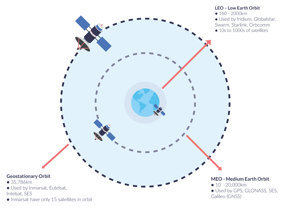
This diagram shows the relative distance from Earth of the three satellite orbits, with Low Earth Orbit closest to the earth at 160 – 2,000km (99 – 1243 miles), and Geostationary orbit the furthest away, at 35,786 km (22,236 miles). Medium Earth Orbit (MEO) satellites are more rare; only 10% of satellites are orbiting at this height, and they are used almost exclusively for GPS and related services, rather than communications. Though both Intelsat and Viasat have filed for MEO constellations with the Federal Communications Commission, the latter of which was approved in 2020.
Satellites in Low Earth Orbit
Satellites in Low Earth Orbit (LEO) travel at a high speed, taking only around 90 minutes to orbit the Earth. While this speed allows for a quick coverage of the entire planet, it also presents challenges for communication. If a single satellite were to move at this speed, ground stations on Earth would have difficulty keeping track of its location, making communication impractical.
To address this issue, communication satellites in LEO are deployed in a constellation, consisting of multiple satellites that work together to ensure continuous coverage. The satellites in the constellation pass data between them, effectively creating a network around the Earth. When one satellite moves out of range, another satellite in the constellation picks up the signal, maintaining a seamless connection between the sender and receiver. This configuration ensures that there is always at least one satellite in view of any point on Earth, allowing for reliable communication even in remote locations.
By utilising a constellation of satellites in LEO, communication providers can offer faster, more reliable services to their customers, including internet connectivity, telephony, and other data services.
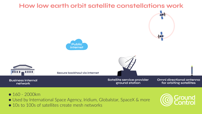
As the diagram above shows, a great benefit conferred by this network is that you don’t have to point your antenna in a particular direction to connect with the satellites. As they’re constantly moving around, there will always be a satellite that picks up the signal, and passes it on so it reaches the ground station. This is particularly useful if you are trying to transmit data from a heavily wooded or hilly area, as you only need to be able to see the sky, rather than needing to find a specific look angle.
Ground stations (sometimes known as earth stations) are where all data from the LEO satellite constellation is sent, and from where it’s transmitted to your base of operations, using the internet.
One advantage of Low Earth Orbit (LEO) satellite constellations is their low latency, which refers to the delay between sending and receiving data. LEO satellites are positioned much closer to Earth than geostationary satellites, resulting in shorter signal travel distances and lower latency. This makes LEO satellites a suitable option for applications such as voice calls or video conferencing, where real-time communication is crucial and delays or slow connections can affect call clarity. With LEO satellite constellations, latency can be less than one second, providing high-quality, low-latency communication.
Satellite communication companies using LEO include Iridium, Globalstar, Starlink and Kinéis.
Satellites in Geostationary Orbit
Satellites in geostationary orbit are geosynchronous with the earth; they’re moving at the same speed as the planet, and so appear to be stationary to us. As they’re in much higher orbit, they can ‘see’ much more of the earth, so fewer satellites are needed to cover a large territory.
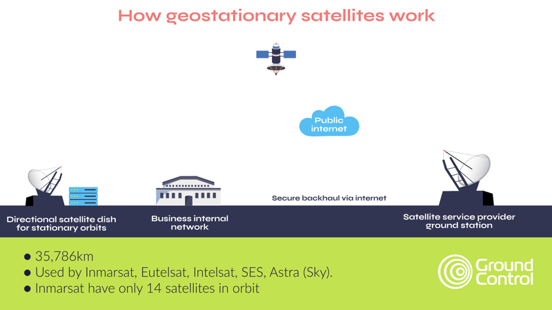
If your antenna or dish doesn’t have an auto-pointing feature, with geostationary satellites, you’ll need to point the antenna at the satellite manually. Typically, devices provide assistance in the form of LED lights and beeping sounds to indicate the signal strength, making manual pointing relatively easy. Once the alignment is established, the connection with the geostationary satellite remains stable, as long as the antenna or dish does not move. This feature makes geostationary satellites a reliable option for applications that demand consistent connectivity, like broadcasting television or providing internet services to remote areas.
Latency is a little slower for geostationary satellites because the data has further to travel; it’s usually less than two seconds for the data to be sent, and redirected to the ground station, which is more than adequate for M2M / IoT applications, and to supply broadband internet. Once at the ground station, the means by which the data makes its way to your business – using the internet – is broadly the same as satellites in low earth orbit.
Satellite communication companies using geostationary orbits include Viasat, Eutelsat, Intelsat, SES and Astra (Sky).
Private Satellite Networks
An option for companies who want zero reliance on public infrastructure is to choose a private satellite network. Here, instead of your data going to a shared ground station, and being sent on to you via secure internet channels, you have your own ground station at your business premises.
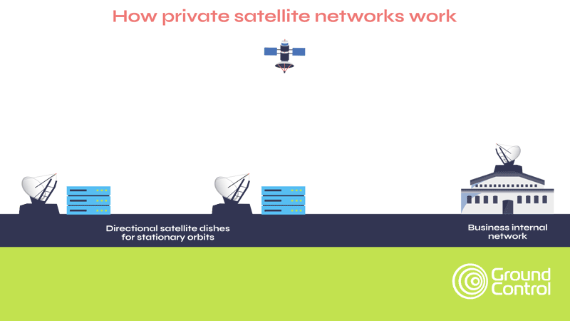
As expected, this solution is costlier than the standard backhaul via internet setup through a ground station. However, it offers customers peace of mind with regards to data security and service reliability. This service is provided by TSAT – the Ground Control product leveraging this service is called the SCADASat.

Would you like to know more?
If you’re a Ground Control customer, you can reach our support team at help@groundcontrol.com, or complete the pop-up form and we’ll make sure it gets to the right team.
If you’re not a Ground Control customer, but would like to learn more about our satellite connectivity services, please complete the form – we would love to hear from you.