Water quality monitoring no longer sits at the edge of operational strategy. It’s at the center of regulatory exposure, public reporting, and engineering accountability.
Designing or managing remote water quality monitoring systems lays the foundation for data continuity, defensible timestamps, and structured reporting outputs that withstand regulatory scrutiny. Across the UK, the United States, and other regulated markets, compliance expectations are tightening. Monitoring systems must now deliver continuous data, auditable records, and structured exports suitable for regulator portals and public dashboards.
Satellite IoT plays a defined role in meeting this regulatory need. The right architecture for the job reduces reliance on intermittent or patchy cellular coverage and strengthens confidence in the data transfer. The result is not simply connectivity; it’s system resilience and credibility.
Here we explore two remote water monitoring examples, and what they show about building confidence in the audit trail that follows.
How Regulatory Pressure is Reshaping Monitoring Design
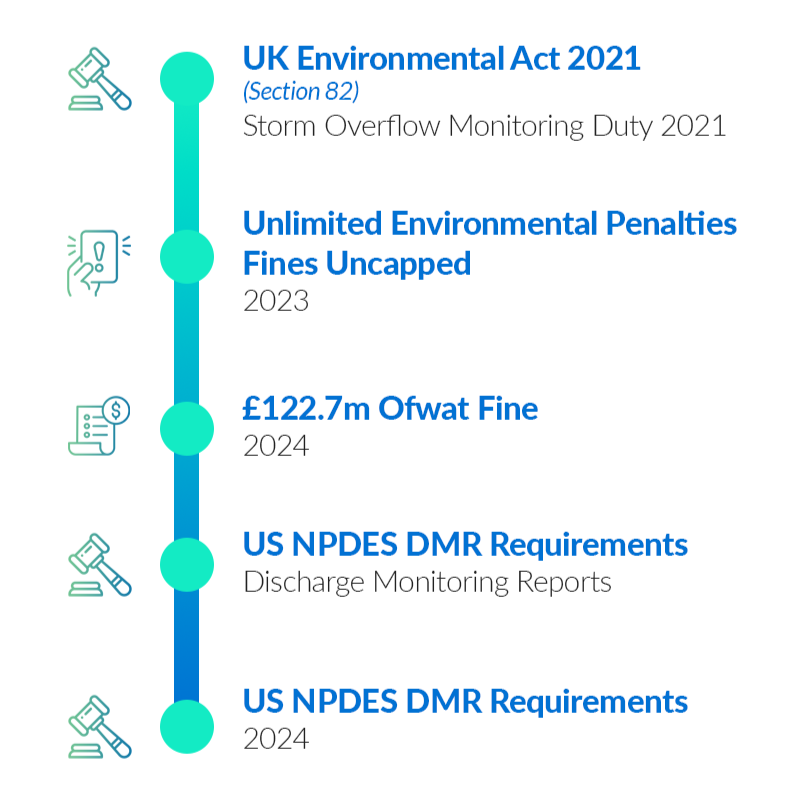
In the UK, the Environment Act 2021 introduced statutory duties around monitoring upstream and downstream of storm overflows and sewage disposal works (Section 82). The UK’s storm overflow policy guidance outlines expectations for monitoring and transparency. Following on in 2023, environmental penalties in the UK were uncapped, removing the previous £250,000 ceiling for serious breaches. Enforcement activity has since reflected this increased accountability.
In the United States, the Clean Water Act operates through the National Pollutant Discharge Elimination System (NPDES). Submitting Discharge Monitoring Reports (DMRs), and reporting violations contribute to the Significant Noncompliance status. In summary, regulatory frameworks are established; what continues to evolve is their technical implication.
How Water Monitoring Systems Support Regulatory Standards

Continuous or near-continuous data capture
Sensors record measurements at defined intervals, creating a consistent stream of operational data.
Time stamped, immutable records
Each measurement is stored with a secure timestamp, preserving a verifiable historical record.
Documented uptime and connectivity behavior
The system logs device status and communication performance across the monitoring lifecycle.
Clear traceability and secure data retention
Collected telemetry is stored in protected systems designed to preserve operational and compliance records.
API export capability for regulator integration
Monitoring data can be programmatically exported into reporting, compliance, and regulatory systems.
Why Connectivity Determines Confidence
Many remote river gauges, reservoirs, and discharge sites sit outside reliable cellular coverage. Even where coverage exists, service continuity can degrade during extreme weather, power disruption, or infrastructure failure. Total reliance on cellular connectivity introduces exposure.
Satellite IoT addresses this constraint directly. Low Earth Orbit (LEO) networks provide global coverage without dependence on local infrastructure. While satellite is not the right fit for every data profile, it offers coverage certainty where terrestrial networks cannot.
For message-based telemetry, Iridium Short Burst Data (SBD) supports low latency, small payload messaging suited to alarms, status updates, and exception-based reporting. That makes it particularly relevant where compliance-related events need to be captured and transmitted reliably from remote locations.
In practice, resilient remote monitoring often combines connectivity approaches to balance immediacy, scale, and power constraints. The examples below show what that can look like in water utility operations.
Case Study 1: Reservoir Monitoring and Remote Pump Control
The first example involves a remote reservoir that requires dependable monitoring and controlled pump activation despite unreliable cellular coverage. Two RockBLOCK RTUs were installed.
The upper unit measures water level and flow. It operates outside cellular range and uses Iridium SBD to transmit short command and status messages. When the water level is sufficient, it signals the lower RTU to activate the pump.
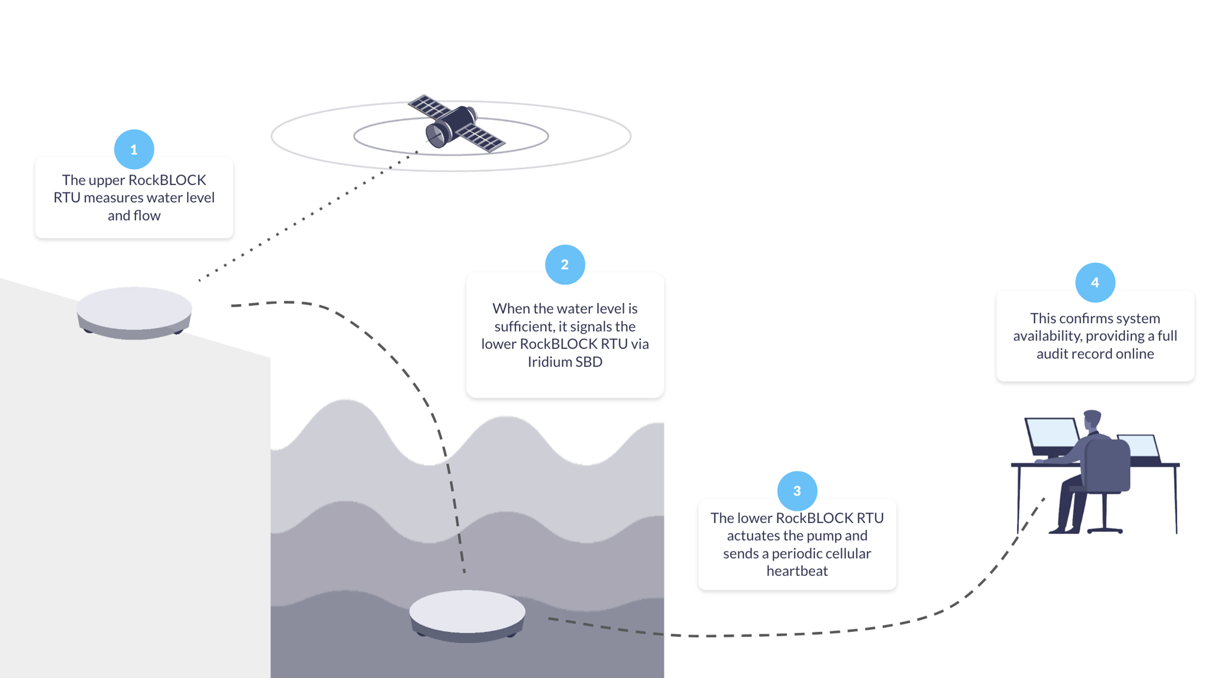
The lower RTU actuates the pump and sends a periodic cellular heartbeat to confirm system availability, providing near-real time confirmation of upstream conditions, controlled pump activation, documented event timestamps, and independent verification of site status.
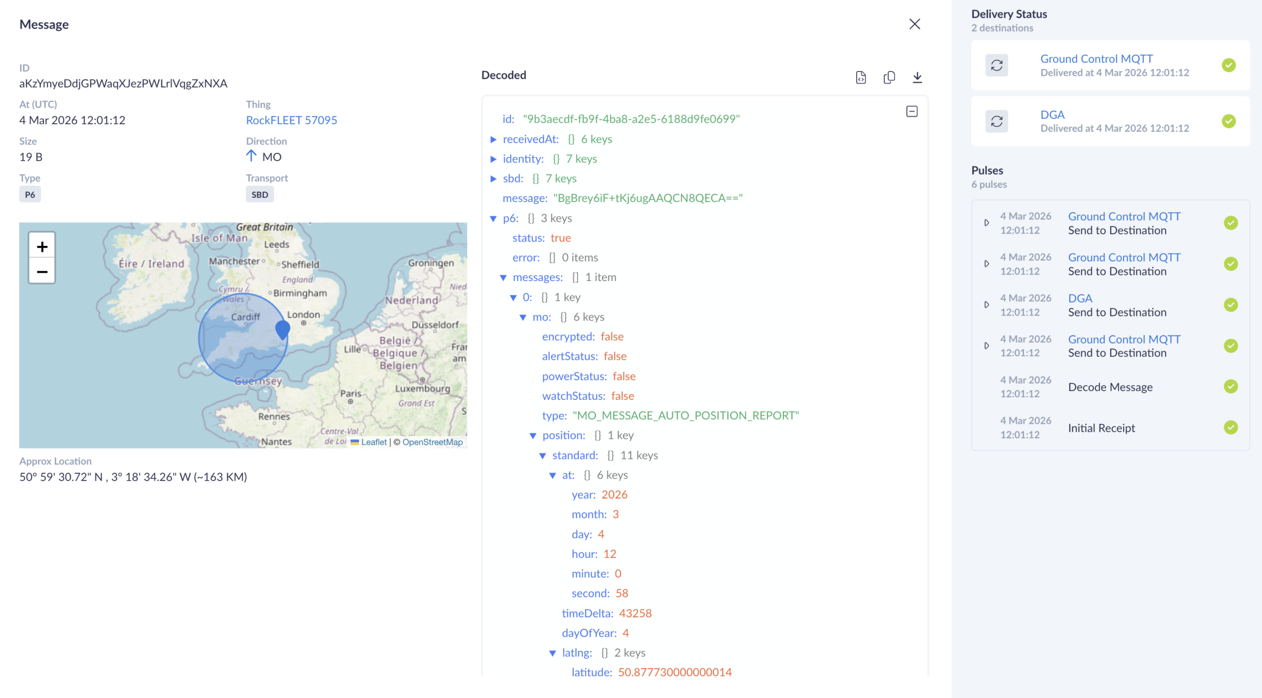
From a compliance perspective, the Cloudloop platform retains a time sequenced record of level measurement, command transmission, pump activation, and heartbeat confirmation. Therefore, if questioned, the operational timeline can be reconstructed.
Case Study 2: River Health Monitoring With Micro Data Logging
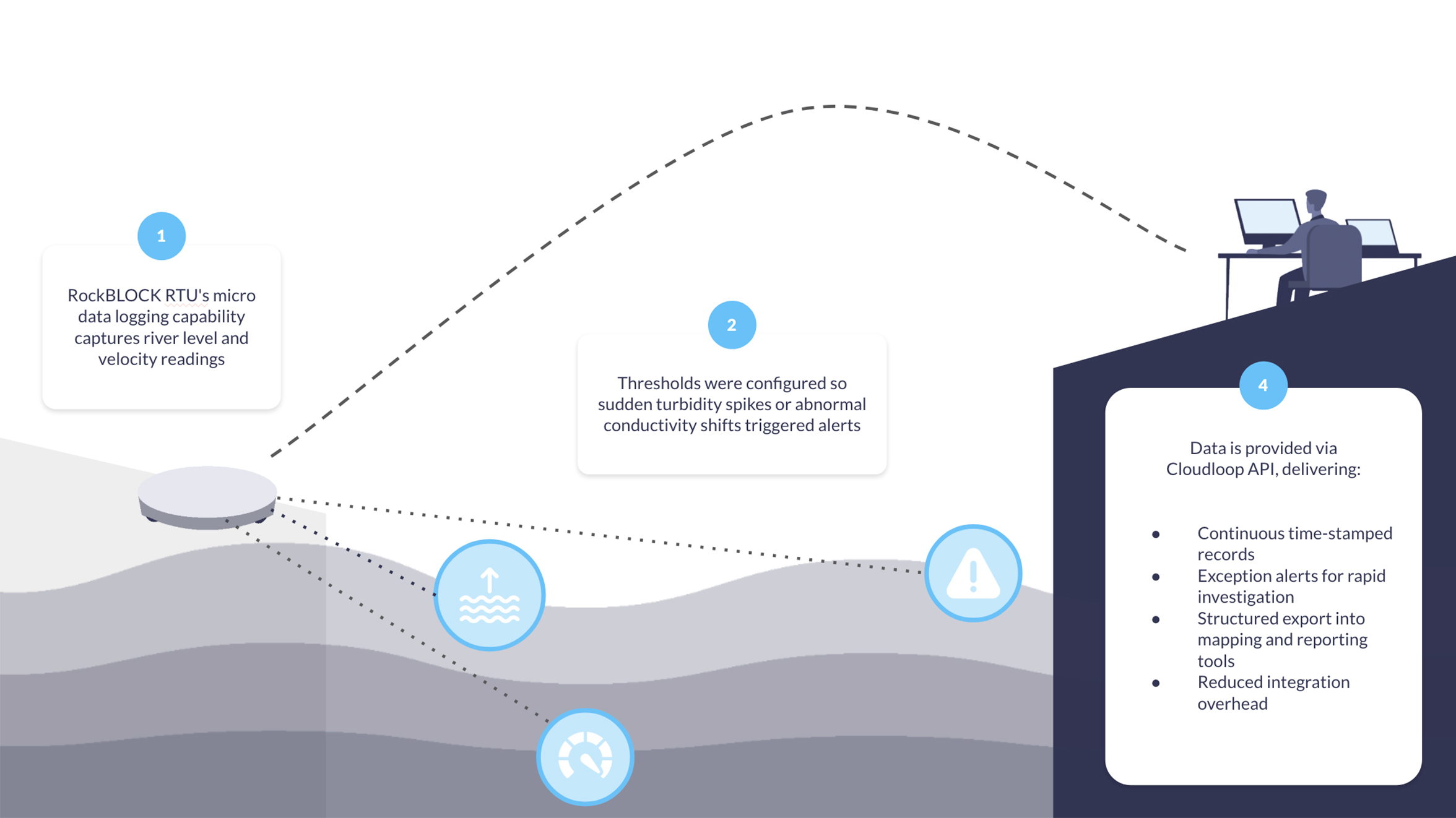
In our second deployment example, a local water authority needed to measure river level and velocity, derive discharge, and capture core water quality indicators. Rather than installing a full stand-alone data logger with integrated satellite comms, RockBLOCK RTU’s micro data logging capability was used to capture essential metrics.
Thresholds were configured so sudden turbidity spikes or abnormal conductivity shifts triggered alerts. Measurements flowed directly into the connected software via Cloudloop API integration.
This approach provided continuous, time-stamped records, exception alerts to support rapid investigation, structured export into mapping and reporting tools, and reduced integration overhead. For remote water monitoring more broadly, logging infrastructure and communications layers remain unified rather than fragmented across separate systems.
Building an Auditable Data Pathway
Confidence in remote water quality monitoring doesn’t come from a single device, but from the integrity of the whole data pathway. When time stamps are preserved across each layer, transmissions are acknowledged, and configuration changes are logged, reliance on manual consolidation falls, reducing errors and saving both time and money.
Auditability Across the Monitoring Chain
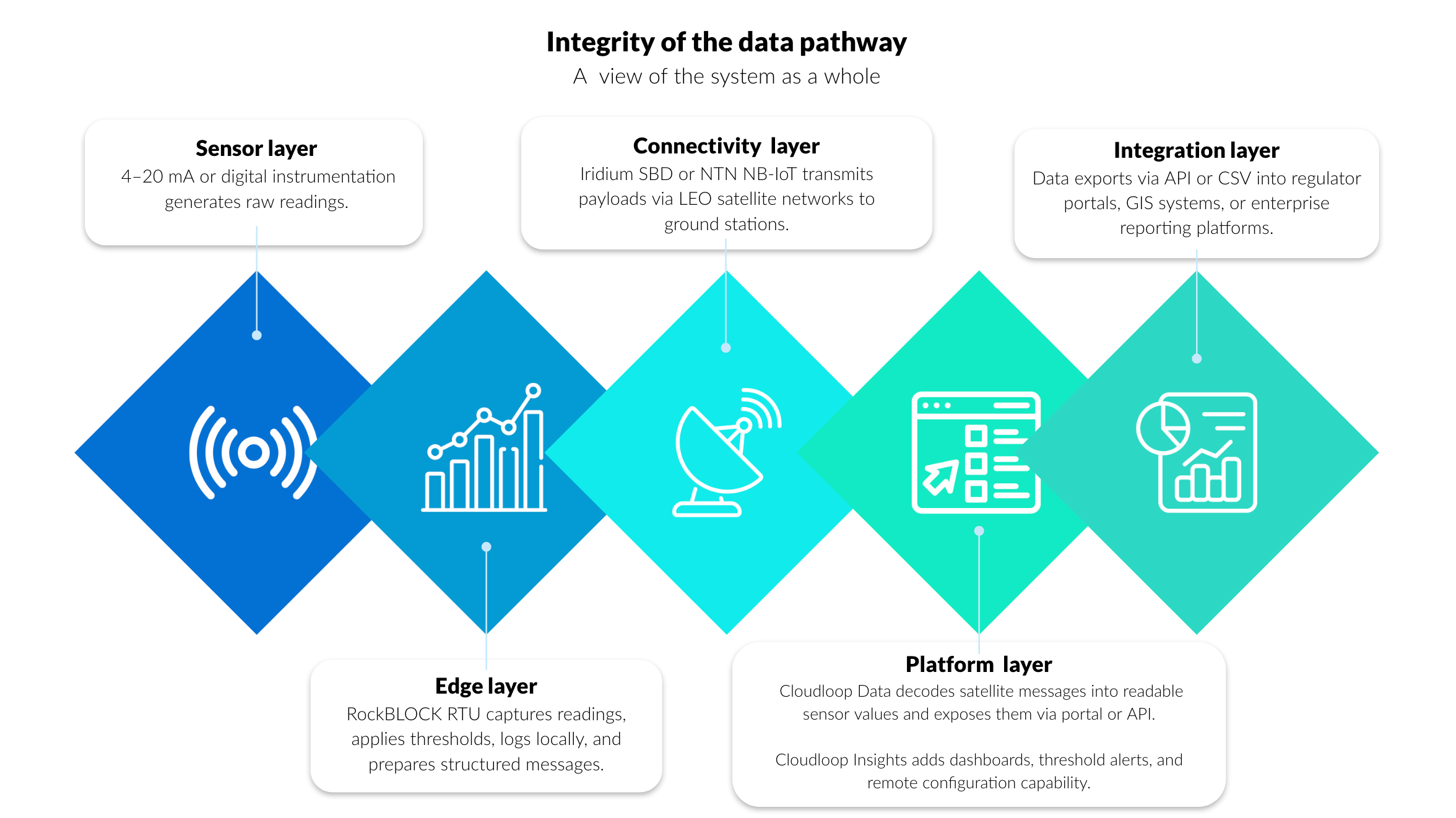
Within the layered architecture described above, the platform layer is where telemetry becomes a structured operational record.
Cloudloop Data provides the ingestion and decoding layer between satellite transmission and operational systems. Messages received from RockBLOCK RTU are converted into readable sensor values, normalized, time stamped, and made available through a secure portal or API.
This removes the need to manage raw payload parsing internally and helps ensure each transmission is logged with the metadata needed for traceability, including device identity, transmission time, and delivery status.
In the reservoir monitoring example, level measurements, command triggers, and pump activation confirmations are preserved as a time-sequenced operational record.
In the river health deployment, turbidity and conductivity alerts are decoded and logged with consistent metadata before export into reporting and GIS tools.
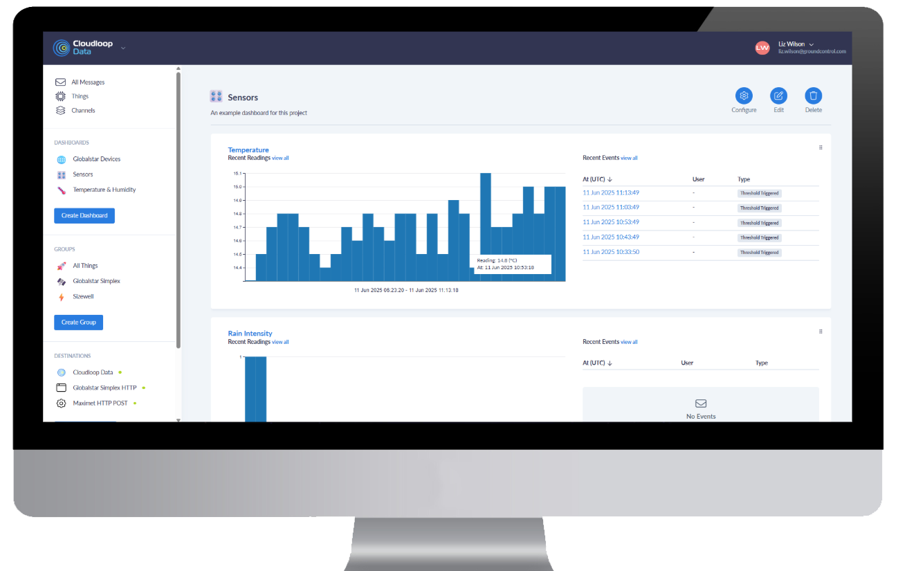
Visualizing and Integrating Monitoring Data
Cloudloop Insights builds on that structured data foundation by providing visualization, threshold configuration, and remote device control. Dashboards show both live and historical values, while threshold breaches, device status changes, and configuration updates are retained as part of the operational record, helping link system behavior back to defined monitoring parameters.
Both Cloudloop Data and Cloudloop Insights expose APIs, allowing telemetry and control data to flow into regulator submission tools, GIS environments, enterprise asset management systems, and custom EMS platforms. This API-first approach supports automated export for NPDES or UK reporting workflows, structured integration with mapping systems, programmatic access to historical telemetry, and closer alignment between remote measurement and institutional record-keeping.
As remote water quality monitoring comes under greater regulatory scrutiny and public visibility, monitoring systems need to support continuous measurement, structured reporting, and reconstructable data lineage across distributed, infrastructure poor environments. Together, these examples show how message-based satellite telemetry, edge logging, and structured platform integration can support compliance-grade monitoring.

Can we help?
If you are reviewing or upgrading a remote monitoring architecture, our Technical Solutions team can help assess site conditions, regulatory obligations, sensor requirements, latency needs, and audit trail completeness.
Complete the form or email hello@groundcontrol.com and we’ll get back to you within one working day.