For decades, maritime operations have relied on GNSS technologies such as GPS as the foundation of navigation. From ECDIS and AIS to fleet tracking, dynamic positioning, voyage optimization and security monitoring, almost every aspect of a vessel’s operational picture depends on accurate positioning, navigation and timing data. As a result, many operators have come to view GPS as a permanent, dependable utility that simply works in the background.
However, the maritime operating environment is changing. According to the 2026 Royal Institute of Navigation (RIN) Maritime GNSS Interference Report, 75% of mariners surveyed believe GNSS interference is increasing in frequency and severity. The report concluded that jamming, spoofing and other forms of interference now represent a significant safety and security concern for global shipping.
At the same time, the maritime industry is becoming more dependent on positioning data than ever before. Navigation, compliance, fleet management, security operations and digital reporting systems all rely on trusted location information. When GNSS integrity is compromised, the consequences extend far beyond the bridge and affect navigation, AIS, communications, timing systems and fleet monitoring simultaneously.
This growing challenge is driving interest in Assured Positioning, Navigation and Timing (A-PNT) technologies, but it is also creating confusion. What exactly is A-PNT? How does it work? Can it replace GPS? Is it accurate enough? And why are more maritime operators looking at solutions such as RockFLEET Assured powered by Iridium PNT?
To answer those questions, let’s separate fact from fiction.
Myth 1: If GPS shows a position, it must be correct
One of the most dangerous assumptions in modern navigation is that a displayed position is automatically a trusted position. Most maritime operators have experienced temporary GPS outages or degraded signals, but spoofing presents a very different challenge.
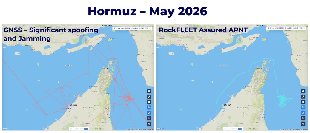
Unlike jamming, which often causes signal loss and triggers alarms, spoofing manipulates GNSS signals to convince a receiver that a vessel is somewhere it is not. The vessel’s navigation systems may even continue to display what appears to be a perfectly valid position, complete with plausible course, speed and track information. To the bridge team, everything may appear normal.
This is what makes spoofing particularly concerning. A vessel can be provided with a believable but entirely false navigational picture while vessel operators, bridge crew and shore-side teams remain unaware that anything is wrong. The real challenge is having an independent way to verify that the reported position is genuine and trustworthy.
Myth 2: GNSS interference is only a military problem
There was a time when jamming and spoofing were largely associated with military operations and conflict zones. Today, that assumption no longer reflects reality, with commercial vessels operating in regions such as the Baltic Sea, Black Sea, Eastern Mediterranean, Red Sea and Persian Gulf increasingly encountering GNSS disruption. What was once considered an exceptional event is becoming a routine operational risk. Maritime operators are discovering that navigation resilience is not confined to defense but has become a commercial, safety and compliance issue as well.
As shipping becomes increasingly digitalized, the consequences of GNSS disruption extend far beyond the bridge. Fleet management systems, voyage reporting, security monitoring and regulatory compliance processes all depend on accurate positioning data. When that data becomes compromised, the effects can be felt throughout an organization.
Myth 3: The bridge crew would know immediately if GPS was being attacked
Many people assume that any interference with GPS would be obvious. But in reality, the nature of the attack determines how visible it is.
Jamming is often relatively straightforward to identify because GNSS/GPS receivers lose access to the signals they require. Position fixes may be lost, alarms may activate and navigational systems may indicate degraded performance, making operators generally aware that something has happened.
Spoofing, on the other hand, is far more subtle. Because the GNSS/GPS receiver continues to calculate a position, there may be no immediate indication that the data being presented is false. In some cases, a spoofed position may drift very gradually from reality, making it even harder to detect through normal operational procedures. This distinction is one of the key reasons why maritime organizations are increasingly looking beyond traditional GNSS-only navigation architectures.
Myth 4: A-PNT is simply another GPS
A common misunderstanding is that A-PNT exists to replace GPS. In reality, A-PNT is not a single technology, and it’s not shorthand for a satellite-based GPS alternative.
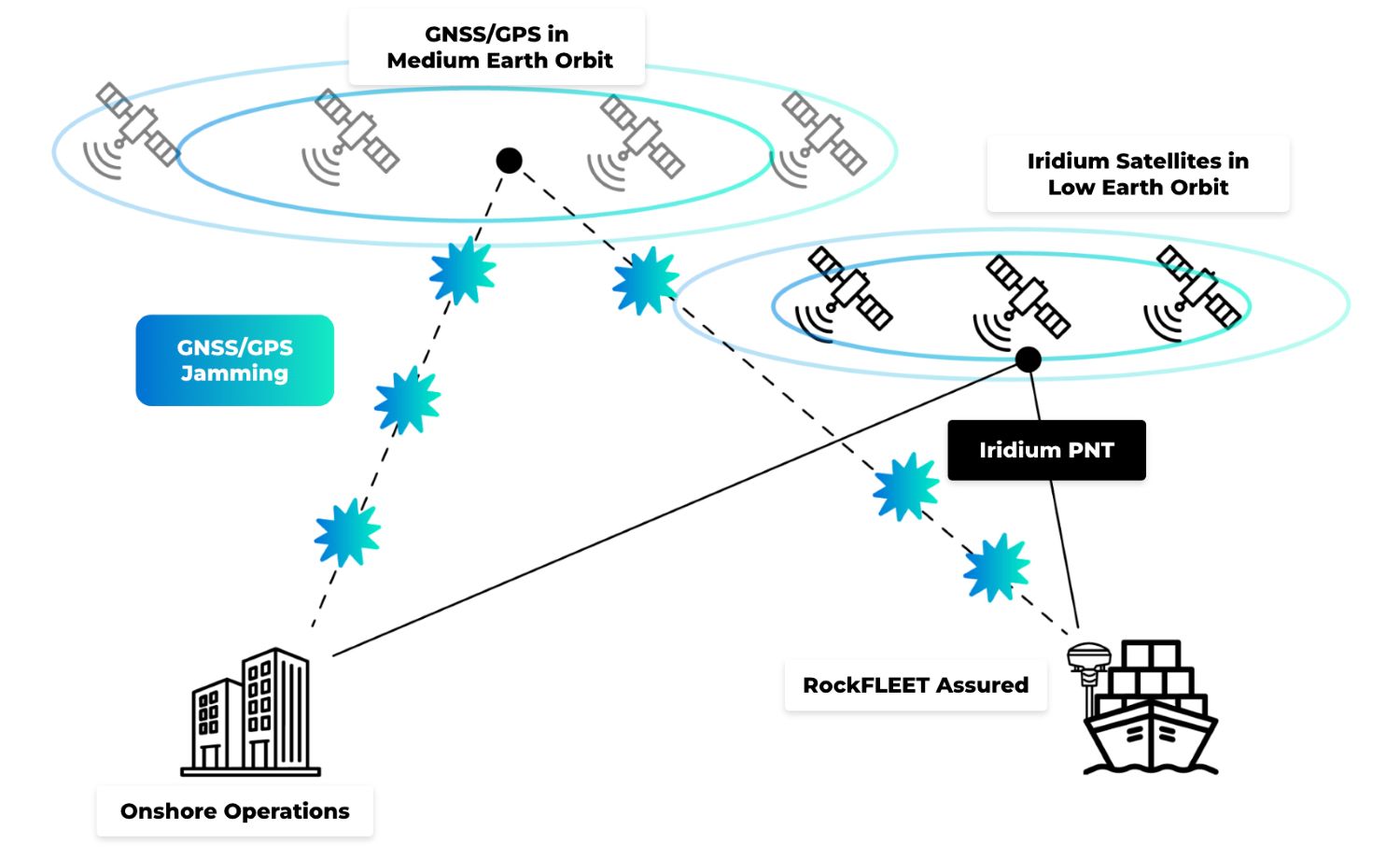
GPS and other GNSS constellations provide positioning, navigation and timing information, but the signals arriving at the Earth’s surface are extremely weak. By the time a GPS signal has traveled approximately 20,000 kilometers from Medium Earth Orbit, it can be vulnerable to interference, intentional jamming and sophisticated spoofing attacks.
This vulnerability is one of the reasons GNSS disruption has become such a significant concern for maritime operators.
 A-PNT technologies are designed to address this challenge by adding independent sources of trusted positioning, navigation or timing information when GNSS integrity becomes unreliable. The objective is to help operators determine whether the position information they are using can be trusted.
RockFLEET Assured takes this approach using Iridium PNT technology as an independent source of assured positioning. Unlike GPS satellites operating approximately 20,000 kilometres above the Earth, the Iridium constellation operates in Low Earth Orbit, meaning its satellites are around 25 times closer to the Earth’s surface than traditional GNSS satellites.
That difference matters. The stronger LEO signal makes Iridium PNT more resilient to many forms of interference and harder to overwhelm through conventional jamming techniques.
Just as importantly, Iridium PNT provides authenticated positioning information that can be used independently of GNSS. This gives operators a trusted reference point against which GPS-derived positions can be compared.
So A-PNT is not “another GPS”. It’s a way of improving confidence in position, navigation and timing when GNSS can no longer be assumed to be reliable. In RockFLEET Assured, Iridium PNT provides the independent reference that makes that assurance possible.
Myth 5: A-PNT is intended to replace existing navigation systems
Modern maritime navigation has always been based on cross-checking information from multiple sources. Experienced mariners do not rely on a single radar, a single sensor or a single chart reference. Instead, navigational confidence comes from verification.
The same principle applies to positioning.
Radar, visual observations, ECDIS, AIS, gyrocompasses and GNSS all contribute to situational awareness, and A-PNT fits naturally within this layered approach. The ability to compare independent sources of positioning information gives operators greater confidence when data aligns and provides an early warning when it does not.
Rather than replacing existing systems, A-PNT provides an independent reference that allows bridge crews and shore-side teams to validate critical navigation data to confirm whether it can be trusted, identify potential GNSS anomalies and make more informed decisions.
Myth 6: Shore teams will always spot a spoofing incident
Fleet monitoring centres can be a valuable safeguard against navigational anomalies, but effectiveness is often limited by the fact that they rely on the same GNSS-derived data the vessel is using. If a ship’s navigation system is receiving a spoofed position, that incorrect information may also be transmitted through AIS, fleet tracking platforms and operational reporting systems.
As a result, both the vessel and the shore team can end up sharing the same inaccurate picture. Rather than providing an independent check, the entire operational chain becomes dependent on compromised data. This is where A-PNT provides significant value by offering a trusted reference point independent of GNSS signals.
Myth 7: Accuracy is all that matters
When evaluating positioning technologies, many operators instinctively focus on accuracy; while accuracy remains important, it’s only one part of the equation.
In a spoofing scenario, a GNSS receiver may report exceptional accuracy while still providing a completely incorrect position. A-PNT shifts the focus from accuracy alone to integrity and trustworthiness. In GNSS and GPS denied environments, understanding whether a position can be relied upon becomes just as important as knowing how many meters of accuracy it claims to provide. For maritime decision makers, trusted positioning often matters more than marginal differences in precision.
RockFLEET Assured combines authenticated positioning with practical operational accuracy. Performance improves when multiple Iridium satellites are overhead and, because the Iridium constellation naturally clusters towards the polar regions, positioning performance becomes even stronger at higher latitudes. For example, typical median positioning accuracy is approximately 25 meters in Norway (69°N) and around 42 meters in the Red Sea (19°N), providing a reliable independent position reference across global shipping routes.
For large commercial vessels, tankers, bulk carriers and container ships measuring well over 100 meters in length, this level of accuracy is highly operationally valuable. Whether validating a vessel’s reported position, supporting fleet monitoring or identifying GNSS anomalies, a trusted position accurate to within a few tens of meters is far more valuable than a highly accurate GPS position that has been spoofed or disappears altogether due to jamming.
Myth 8: Assured positioning means replacing existing systems
A common misconception is that improving positioning resilience means making extensive modifications to a vessel’s existing navigation systems.
In practice, this doesn’t have to be the case. A-PNT is a broad approach to improving confidence in positioning, navigation and timing when GNSS cannot be assumed to be reliable. How it is implemented depends on the vessel, the operational requirement and the technology being used.
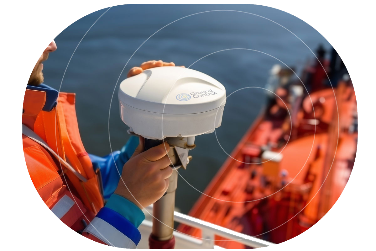
RockFLEET Assured has been developed with practical vessel installation in mind. The system comprises a compact Above Deck Unit that can be mounted in a suitable location with up to 100 meters of cabling, giving installers flexibility across a wide range of vessel types and layouts.
Once installed, RockFLEET Assured integrates with existing bridge and operational systems using standard maritime interfaces, including NMEA protocols. This means assured positioning data can be shared with navigation, monitoring and reporting systems already in use, without requiring major changes to established bridge workflows or operational procedures.
For fleet operators, this helps minimize installation complexity, reduce downtime and avoid the need for wholesale replacement of existing navigation equipment.
The result is a practical enhancement to a vessel’s navigation resilience, rather than a complete redesign of its navigation infrastructure. Bridge teams can continue using familiar systems, while RockFLEET Assured provides an independent source of authenticated positioning information that helps them validate GNSS data and make more confident navigational decisions.
Myth 9: GNSS only affects navigation
The term GNSS often leads people to think exclusively about chart displays and route planning, but in practice, positioning, navigation and timing (PNT) data underpins a much broader range of maritime operations.
Accurate position information influences AIS transmissions, fleet monitoring, voyage reporting, security operations, geofencing, compliance requirements and incident investigations. Timing information also plays a critical role in synchronising systems and maintaining operational consistency.
When GNSS integrity is compromised, the effects extend far beyond the bridge. An inaccurate position can quickly become an inaccurate operational picture across the entire organization.
Myth 10: A-PNT is only relevant in high risk regions
GNSS jamming and spoofing are most frequently reported in geopolitical hotspots, but navigation resilience should not be viewed as something only needed when operating in high risk waters.
Commercial vessels rely on trusted GNSS/GPS and PNT data throughout every voyage and as fleets become more connected and digitalized, dependence on this data continues to grow. That means the consequences of compromised positioning extend far beyond navigating through a conflict zone; it can affect operational efficiency, regulatory compliance, fleet visibility and decision-making across an entire organization.
Forward-thinking shipowners and fleet operators are therefore beginning to view A-PNT as part of a broader navigation resilience strategy rather than a solution reserved for exceptional circumstances. The independent position verification that A-PNT delivers provides an additional layer of resilience, helping bridge teams and shore-based operators maintain confidence in the information they rely on, wherever their vessels operate.
Further, as digital shipping and increasingly automated vessel operations continue to evolve, trusted positioning is likely to become a fundamental requirement for safe, resilient and efficient maritime operations, not just in high risk regions, but across the global shipping industry.
Building Confidence in a Contested Navigation Environment
While the maritime industry’s utilization of GNSS has delivered enormous operational benefits, it has also introduced new vulnerabilities. Jamming and spoofing are not concerns discussed only in military circles, but are real world incidents across the world’s busiest shipping lanes.
The focus is shifting from simply obtaining a position to ensuring that the position can be trusted. That’s why A-PNT solutions such as RockFLEET Assured, powered by Iridium PNT, play an increasingly important role. RockFLEET Assured provides maritime operators with something increasingly valuable in today’s contested navigation environment: an independent, authenticated and resilient source of positioning information.
In a world where navigation systems can be deceived, resilience comes not from having more data but from having greater confidence in the data you use. The future of maritime navigation will therefore be defined not solely by accuracy, but by assurance, integrity and trust.

Any more questions?
If you didn’t find the answer you were looking for, or if you’d like to discuss how A-PNT could enhance your GPS and GNSS architecture, our team is here to help.
Simply fill out the form, and one of our experts will get back to you to talk through your requirements, explore the solutions, and help you plan your next steps.
Whether you’re just starting to explore A-PNT or are ready to move ahead with an A-PNT solution, we’ll work with you to find the right device for your application.