Global Navigation Satellite Systems (GNSS) such as GPS, Galileo, GLONASS, and BeiDou have driven navigation for Unmanned Aerial Vehicles (UAVs) for decades. These satellite signals provide critical positioning, navigation, and timing (PNT) data that inform core functions like waypoint navigation, path planning, dynamic obstacle avoidance, geofencing for airspace compliance, and failsafe behaviors such as Return to Home or auto landing. However, GNSS/GPS signals are inherently weak – designed to be received at the Earth’s surface from satellites tens of thousands of kilometers away – and as such, are vulnerable to interference, jamming, or deliberate PNT denial.
Particularly over conflict zones, but increasingly widespread, GNSS signals are being degraded, spoofed, or blocked, causing multipath errors and signal loss and leaving autonomous drones without reliable positioning or timing information. Reliance on GNSS alone subsequently becomes a single point of failure for safe, reliable and trusted and UAV operations.
This is why navigation resilience has become one of the most important technical and operational requirements for modern BVLOS UAV deployments, and why selecting the right navigation solution is no longer simply about accuracy, but about operational continuity, trust, and reliability when navigational conditions degrade.
In this blog, we’ll explore the satellite service that addresses GNSS/GPS overreliance, the onboard technology that delivers resilient UAV navigation in contested environments, and the key factors integrators should consider when choosing a navigation stack for BVLOS operations.
Continuity Challenges in Contested and Complex Environments
Studies on GNSS-denied navigation show that jamming can overwhelm genuine satellite frequencies, driving receivers into error or total loss of signal. Spoofing goes a step further by feeding convincing but false signals, tricking receivers into calculating an incorrect location and potentially sending autonomous systems off course. This isn’t theoretical – the mechanisms and impact of GNSS spoofing and jamming are well documented, with spoofing described as a more complex and deceptive threat than simple interference, because it actively misleads the navigator rather than just depriving it of data.
GNSS denial isn’t confined to military battlefields either. Complex civil environments present similar challenges. Urban canyons made of steel and glass can reflect, attenuate, and distort satellite signals. Industrial zones rife with electromagnetic activity can drown out weak satellite broadcasts. Remote farmlands, border regions, and mountainous terrain all produce signal shadows and multipath effects, and these are not edge cases; many operators encounter these conditions regularly.
Without trusted PNT, a drone’s ability to follow a flight plan, maintain orientation, and sense its environment becomes compromised. In military operations, this can mean the difference between mission success and failure when conducting reconnaissance, supply delivery, or coordinated swarm operations. In maritime environments far from land, relying solely on GNSS undermines situational awareness and safety. In these contested or degraded environments, drones that depend exclusively on GPS risk mission degradation, erratic navigation, or complete loss of control.
It’s worth noting, however, that when a UAV loses trusted PNT, it doesn’t necessarily lose the ability to fly. Rather, it loses confidence in where it is, and that uncertainty is enough to abort missions, degrade data quality, violate airspace restrictions, or erode operator trust. Without PNT, UAV missions fail not because the vehicle lacks propulsion or control, but because it cannot navigate with confidence. For BVLOS operations, this loss of confidence is especially critical. Unlike VLOS flights, BVLOS operations depend on automation, remote supervision, and regulatory compliance. A drone that cannot prove where it is – reliably and continuously – cannot safely remain in controlled airspace or operate near people, infrastructure, or other aircraft.
The Solution Beyond GPS
To address the vulnerabilities in GNSS/GPS, engineers and operators are turning to Assured Positioning, Navigation and Timing (A-PNT).
A-PNT represents a layered approach in which GNSS is complemented, and in some cases temporarily replaced, by alternative sources that can provide trusted PNT data in environments where GPS is unavailable or untrusted. One alternative A-PNT source is derived from Iridium, and broadcast from a constellation of Low Earth Orbit (LEO) satellites. Because these satellites orbit significantly closer to Earth than traditional GNSS satellites, the downlink signals are up to 1,000 times stronger and more resistant to jamming or obstruction.
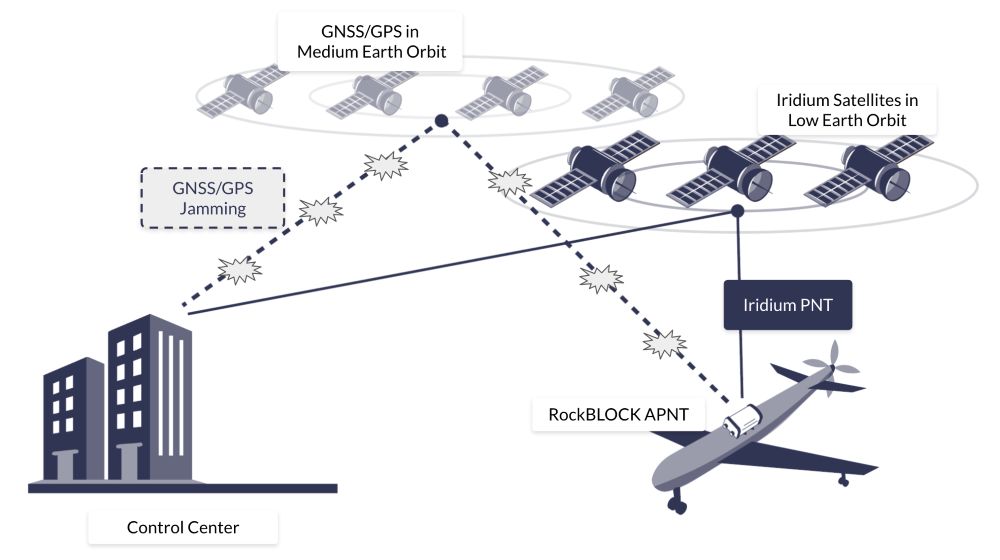
What makes Iridium’s PNT particularly effective is also its hybrid operation. When GNSS signals are present and reliable, an A-PNT system can blend that positioning data with Iridium PNT to maximise accuracy. When GNSS fails or is compromised, the system can continue operating on the stronger, authenticated Iridium PNT signals alone, preserving continuity of service and trusted navigation. This redundancy is key for autonomous systems that cannot afford to lose their bearings due to interference or contested signals.
In addition, the Iridium PNT signal incorporates cryptographic authentication that enables receivers to verify the integrity of their navigation signals and reject spoofed or tampered data. Whether operating at sea, in urban canyons, or in warfare environments, A-PNT provides a resilient and secure source of position and timing that can help autonomous drones sustain operations when GNSS cannot be trusted.
Why Antenna Positioning Still Matters in GNSS-Denied Scenarios
Even before GNSS is intentionally denied, the physical realities of a UAV or drone’s design can degrade satellite reception. The placement and orientation of antennas determine how effectively a platform can see the sky and receive navigation signals.
Placement near high current electronics, motors, or carbon fiber structures can block signals and create multipath interference, both of which erode signal quality. In contested environments, where robust reception is already tenuous, such degradation only exacerbates the problem. Careful antenna placement – including optimal sky visibility, proper ground planes, and physical isolation from noisy subsystems – remains foundational to any navigation strategy that seeks resilience when GNSS signals are challenged or absent. Further, incorporating A-PNT sources into those antenna systems becomes essential to maintaining navigation and timing.
RockBLOCK APNT for Autonomous and UAV Platforms
One of the standout implementations of this A-PNT approach is RockBLOCK APNT – a rugged, self-contained satellite device designed to deliver Iridium PNT-based positioning data even in GNSS-denied environments. RockBLOCK APNT integrates both Iridium PNT and multi-constellation GNSS reception into a compact device suitable for integration with drones and other unmanned systems. By leveraging Iridium’s globally available, authenticated PNT signals, RockBLOCK APNT delivers a level of navigational assurance that GPS alone cannot provide.
For UAV manufacturers and integrators, A-PNT needs to be both practical and reliable. Built with an IP66-rated rugged enclosure, RockBLOCK APNT withstands harsh operational conditions across land and aerial deployments, making it suitable for military, industrial, and maritime applications where environmental stresses and contested RF conditions are common.
The design is also considerate of OEM deployment, featuring a compact form factor with low size, weight, and power (SWaP) requirements, and standard interfaces that simplify integration into existing navigation stacks. It is designed to be both resilient and flexible, supporting serial, USB-C, and Bluetooth connectivity, and easily configurable with common development tools.
Notably, the device also operates with twin antennas to optimize sky visibility and signal resilience according to the drone’s design. In addition to delivering trusted PNT data, RockBLOCK APNT also provides two way satellite messaging up to 100 KB, offering a valuable fallback communications channel when other links fail.

For UAVs and drones operating BVLOS, the ability to compare GNSS and Iridium PNT data streams is a powerful tool for detecting anomalies indicative of interference or spoofing. By validating position and timing against independent sources and reducing dependence on a single satellite navigation source, RockBLOCK APNT enhances navigational integrity and situational awareness. Operating on stronger Iridium PNT signals also expands the envelope of reliable navigation to areas where traditional GNSS geometry is poor or disrupted, such as high latitudes or deep urban corridors.
Future-Proofing UAV Operations With A-PNT
GPS and GNSS have served the world of autonomous navigation well, but they were never designed with modern contested environments in mind. As threats evolve and operations push into regions of intentional interference or obstructed signal conditions, autonomous systems must adapt.
If GNSS is your only source of PNT, your unmanned platform has a single point of failure. In environments where GNSS signals can be jammed, manipulated, or unavailable, this reliance represents a significant operational liability.
A-PNT, powered by strong alternative signals such as Iridium PNT and delivered through devices like RockBLOCK APNT, offers a practical, resilient path forward. By blending multiple navigation sources and validating integrity through authenticated signals, autonomous drones can maintain reliable PNT and continue operating effectively, even when GPS fails.
RockBLOCK APNT delivers UAVs a trusted, independent, and resilient source of positioning, navigation and timing. This enables UAVs to maintain autonomy under interference, preserve mission continuity, protect critical timing and coordination functions, and operate globally with confidence.

Trusted A-PNT For Resilient UAV and Drone Operations
Ground Control brings more than 20 years of experience delivering resilient satellite solutions for remote connectivity and secure communications. We provide expert guidance on deploying the right mix of A-PNT capabilities and reliable satellite connectivity options to ensure trusted positioning, navigation, and for autonomous drones, aircraft and UAVs.
Complete the form, or email hello@groundcontrol.com and we’ll reply within one working day.