From commercial shipping lanes and port approaches to offshore energy platforms and autonomous vessel trials, trusted Positioning, Navigation, and Timing (PNT) underpins safety, efficiency, and regulatory compliance. Every decision from route optimization to collision avoidance relies on accurate and continuous positioning data, and for decades, Global Navigation Satellite Systems (GNSS), including GPS, GLONASS, Galileo, and BeiDou, have served as the backbone of maritime PNT.
These systems provide global coverage, high accuracy under ideal conditions, and enable reliable tracking of maritime operations at scale. However, there is a well documented rise in maritime GNSS/GPS disruption, including deliberate jamming and increasingly sophisticated spoofing attacks. The reality is, conventional GPS-based solutions were never designed for today’s contested, congested, and adversarial signal environment, with traditional GNSS/GPS signals increasingly exposed in ways that were not anticipated when they were first deployed.
Traditional mitigation and defence strategies attempt to address these risks but often fall short; as a result, existing GPS-based solutions are reactive rather than resilient. For instance, they can identify when something is wrong, but are not inherently designed to guarantee reliable, trusted positioning when GNSS is compromised. The result is operational risk that extends beyond safety and security, and to efficiency, insurance exposure, regulatory compliance, and ultimately, trust in maritime systems. This is where Assured PNT enters the conversation and where Iridium PNT positions itself as a fundamentally different approach.
This blog explores how existing maritime GPS solutions are no longer equipped for today’s evolving threat landscape, and how Iridium PNT enables reliable, trusted, and continuous maritime operations in compromised GNSS/GPS environments.
The Cracks in Conventional Maritime GPS
1. Anti-Jamming GNSS Systems
Anti-jamming GNSS systems were developed to suppress interference using directional antennas and filtering techniques. These methods work by attempting to block out noise and prioritise signals that appear clean. However, the threat landscape has evolved beyond simple interference. Modern threats don’t just jam, they deceive. Combined jamming and spoofing attacks create ambiguous signal environments where systems must decide which signals are real and which should be ignored. The result is confusion, with decision making becoming uncertain precisely when certainty is required.
2. Anti-Spoofing Technologies
Anti-spoofing solutions attempt to validate whether a signal is genuine or manipulated, and often rely on similar logic and assumptions as anti-jamming technologies of rules-based detection and signal validation. But the logic and assumptions are increasingly outdated. As spoofing techniques have become more advanced with greater precision and adaptability, these systems have struggled to keep pace. Signal mimicry is more precise, timing offsets are subtler, and attack patterns are adaptive – more closely resembling legitimate behaviour. This leaves anti-spoofing approaches in a reactive rather than predictive position, constantly trying to respond to threats that are evolving faster than the defences designed to stop them.
3. Multi-GNSS Receivers
Using multiple constellations (GPS, Galileo, GLONASS, BeiDou) is often framed as a way to improve resilience, but in practice, it introduces more inputs without addressing the core weakness. GPS, Galileo, and other systems share similar signal structures and operate in comparable frequency ranges, which makes them vulnerable to the same types of interference and spoofing. When disruption occurs, it tends to affect all constellations in similar ways, meaning having more signals does not equate to having more trustworthy information. If one is compromised, the likelihood is high that others are affected as well. This creates a false sense of redundancy, i.e., more inputs, but not more independence.
4. Differential GPS (DGPS)
DGPS enhances positional accuracy using ground-based correction signals, and in stable environments, it performs well. But accuracy is not the same as trust. DGPS still depends on the integrity of the underlying GNSS signal, and in a jamming or spoofing scenario, it remains vulnerable in contested environments. In fact, it can amplify risk by making incorrect positioning appear more precise, giving maritime operators a false sense of confidence in data that may already be compromised.
5. Terrestrial Backup System
Terrestrial backup systems (e.g., eLoran, radio navigation systems) provide an alternative to satellite-based positioning by using shore-based infrastructure. While effective in coastal areas, their usefulness diminishes rapidly beyond those boundaries. Coverage is inherently limited, and the cost and complexity of deploying such systems at scale make them impractical for global maritime operations. For vessels operating in the open ocean, these solutions cannot provide the continuity required for safe and efficient navigation.
The Core Issue is Dependency on a Single Domain
Taken together, these approaches reveal a shared limitation: they attempt to improve or protect GNSS/GPS, but they don’t remove dependence on it. Whether through signal reinforcement, interference detection, or redundancy within the same domain, the underlying dependency remains intact.
It’s worth noting that modern bridge systems can present a layered navigational picture by combining GNSS with radar, AIS, INS, and ECDIS. That improves redundancy, but in most merchant vessels GNSS still provides the primary position input, so interference or false data can still degrade overall situational awareness unless it is independently cross-checked.
Ultimately, there are a limited number of truly independent alternatives to fall back on, as most existing mitigations operate as layers within the same ecosystem rather than as genuinely distinct sources of truth. As a result, what appears to be redundancy is, in many cases, simply duplication within a shared vulnerability.
This is the critical gap that Iridium PNT and RockFLEET Assured are designed to address. Rather than attempting to further fortify GNSS-dependent systems, Iridium PNT reduces reliance on any single domain altogether, enabling a more secure, resilient, and multi-domain approach to assured navigation.
Solving GNSS Dependency with A-PNT and Iridium PNT
Assured Positioning, Navigation and Timing (A-PNT) is the idea of maintaining trusted position, navigation, and timing when GNSS is degraded, denied, or untrusted. It goes beyond basic capability to include resilience, integrity, and trust, helping vessels maintain safe navigation, operational continuity, and compliance despite interference.
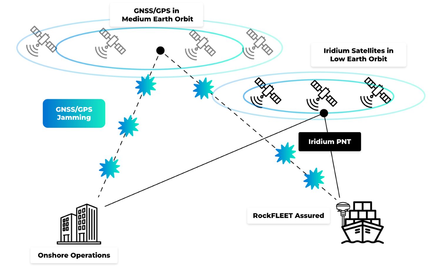
Iridium PNT is one way of delivering that resilience. It’s the only commercially available satellite-based PNT service that operates independently of GNSS, meaning it doesn’t rely on GPS, Galileo, GLONASS, or BeiDou. In a landscape where most backup solutions still depend on the same GNSS/GPS signals, that independence is critical.
Unlike conventional GNSS, which relies on Medium Earth Orbit (MEO) satellites transmitting very weak signals over vast distances, Iridium PNT operates from a Low Earth Orbit, or LEO, constellation, bringing satellites much closer to Earth. This results in stronger signals and contributes to greater resistance to jamming and spoofing in real world maritime environments.
RockFLEET Assured for Resilient Maritime Navigation
RockFLEET Assured represents a necessary shift away from single GNSS/GPS signal dependency. By leveraging the independent and highly secure Iridium PNT signal, vessels aren’t left without a trusted source of navigation data in the event of GPS jamming, spoofing and denial. This enables uninterrupted operations across open ocean, congested shipping lanes, and high risk regions where jamming and spoofing activity is increasingly prevalent.
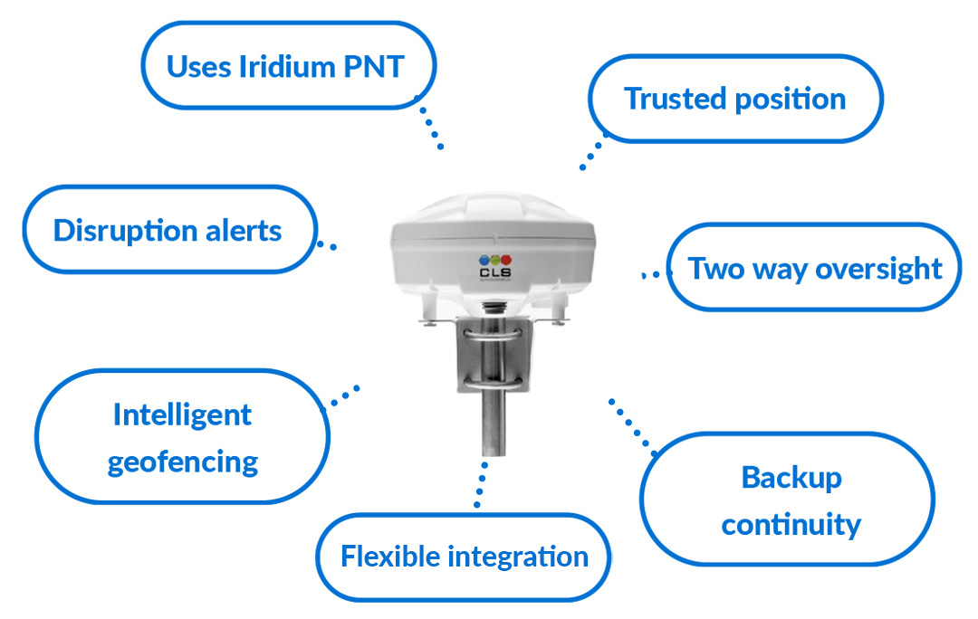
For optimum navigational assurance, RockFLEET Assured continuously compares the trusted Assured PNT position with GNSS and raises alerts when position integrity is at risk. Rather than relying on GNSS alone, it uses an authenticated Iridium PNT position source to help identify anomalies and highlight when GNSS may be jammed, spoofed, or otherwise unreliable.
By cross-checking GNSS against trusted A-PNT data, RockFLEET Assured helps reduce the risk of false positioning and supports safer navigation and better operational awareness. Beyond resilience, it’s also engineered for practical deployment supporting cable runs of up to 100 m for flexible installation, and an optional backup battery that can continue tracking and reporting if vessel power is interrupted.
From Accuracy to Assurance
In today’s maritime and security operations, the core challenge extends beyond positioning accuracy, but trust in the data itself. Existing GNSS/GPS-based solutions, even when layered with mitigation technologies, remain dependent on a single domain that is increasingly exposed to disruption, deception, and interference. This creates a critical gap in trusted, continuous navigation at sea, particularly in contested or high risk environments where GNSS/GPS reliability cannot be assumed.
Iridium PNT and RockFLEET Assured directly address this gap by introducing a truly independent and resilient source of positioning data that operates outside the limitations of traditional GNSS. By combining multi-domain inputs with real time integrity assessment and prioritizing assured, trustworthy signals, they move maritime navigation from reactive detection to proactive resilience. The future of navigation at sea will be defined by this ability to operate with confidence in uncertain and contested GNSS/GPS environments. A-PNT is central to that future, and RockFLEET Assured is built to deliver it.

Trusted A-PNT For Navigational Certainty at Sea
For over 20 years, we’ve delivered resilient satellite solutions for remote connectivity and secure communications. We’re proud to support commercial shipping, offshore operators, and maritime security providers with dependable satellite connectivity and assured positioning capabilities designed for the realities of the modern maritime domain.
If you want to offer A-PNT solutions as part of the security strategy for your maritime clients, complete the form, or email hello@groundcontrol.com and we’ll reply within one working day.