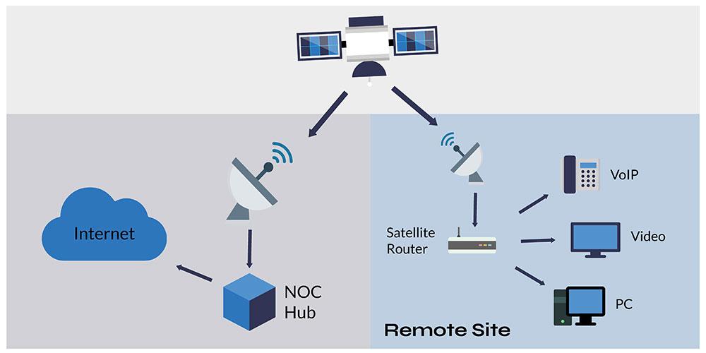
Satellite internet technology allows data transmission and reception via a compact dish located on Earth, which communicates with a geostationary satellite positioned 22,300 miles above the equator. The satellite is responsible for transmitting and receiving data to and from a designated location on Earth known as the Network Operations Center (NOC), pronounced “knock”. The NOC is connected to the internet or a private network, and thus acts as an intermediary for all communication between the satellite dish and orbiting satellite before reaching the internet.
Data communication via satellite is not much different than someone using a land-based data provider, at least from the standpoint of the internet user. The key to remember is that once the satellite system is configured by the installer, satellite service acts nearly identically as any other ISP and may be configured as such. The slight difference of satellite service is described here.
What is a Geostationary Satellite?
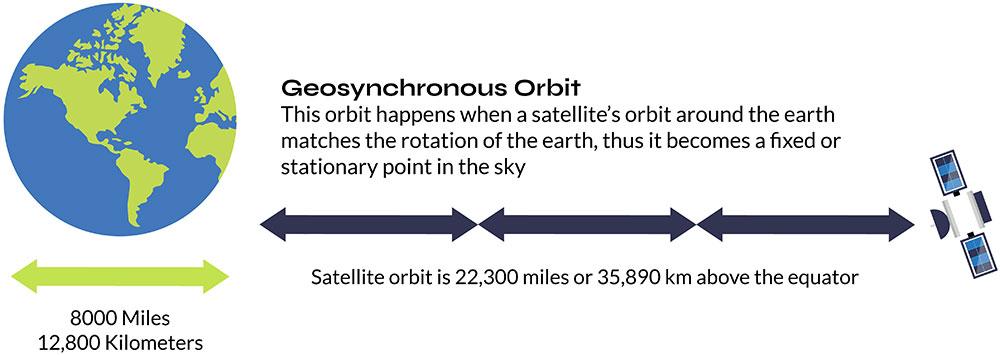
A specific point in space exists where a satellite can be placed in orbit such that it appears motionless from the ground. In reality, the satellite is circling the Earth at the same pace as the Earth’s rotation. This results in the satellite completing one orbit around the Earth in precisely 24 hours, or one day. Geostationary satellites are exclusively positioned at an altitude of 22,300 miles directly above the Earth’s equator and nowhere else.
A Satellite’s Longitude
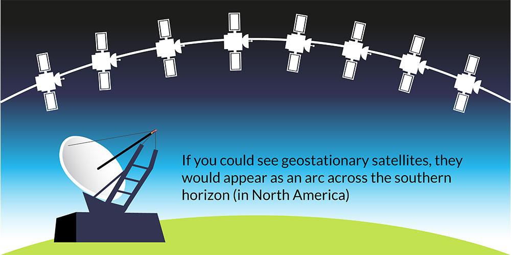
All geostationary satellites have a name like ‘Galaxy 18’ or ‘AMC-4’ and they also have a longitude position. Longitude refers to those imaginary long lines that travel down the Earth for global mapping. There are 360 degrees of longitude readings for Earth. If you know the longitude of a satellite, you knows where the satellite is located in the sky because all geostationary satellites are located above the equator (or zero latitude).
To further confuse things, longitude is divided into two halves: western and eastern hemispheres. All orbital ‘slots’ for satellites would be between 0° to 180° in the eastern hemisphere, and 0° to 180° in the western hemisphere. A satellite orbiting over the Galapagos Islands that services North and South America may have an orbital slot of 101° west longitude. A satellite orbiting over Malaysia that services Asia and Australia may have the orbital slot of 100.5° east longitude.
Satellite longitudes help installers locate where to point a satellite dish. They also help in finding obstacles from an installation location and the satellite.
Satellite Look Angle
Any obstacle (such as a tree or mountain) will interfere with a satellite signal to a geostationary satellite. It is important that there are no obstacles between the installation location of the satellite dish and the orbiting satellite. In the industry, we call this a clear ‘line-of-sight’ to the satellite. Fortunately, finding if there is clear line of sight is is simplified by using a look angle calculator. All that’s needed is a current address (anywhere in the world), and the orbital longitude of the satellite (see description of orbital longitude above).
Plug these two details in, and the calculator will give you a compass heading of the satellite, and the degrees up from the horizon it is located, and a cool overhead picture of the installation location including a line showing the direction of the satellite.
Here is the free look angle calculator from Ground Control.
Satellite Latency
Satellite service differs from other land-based internet service providers in one noticeable way, and that’s the term ‘latency’ frequently used in the satellite industry. Latency simply refers to the amount of time it takes for a single piece of data to complete a round trip over a satellite connection. Another name for latency is ‘ping time’.
Information sent over satellite moves at the speed of light, which is 186,000 miles per second. However, since the orbiting satellite is 22,300 miles away from Earth, data must travel that distance four times, i.e., from computer to satellite, from satellite to NOC/internet, from NOC/internet to satellite, and finally from the satellite back to the computer. The time taken to complete this entire journey is known as latency, which is approximately half a second.
Half a second may not seem like much, but it can impact applications like VPN and real-time gaming, which are sensitive to any time delays. Who wants to wait half a second for their virtual gun to fire after pulling the trigger? Therefore, it’s crucial to understand whether satellite latency will affect your internet usage.
A common misconception is that latency has an effect on transfer rate, or the speed in which you can transfer a file. This is not true. A one megabyte file will transfer just as quickly over a 5 Mbps (megabits per second) satellite connection as it does over a 5 Mbps terrestrial connection. The only difference is that the satellite connection takes a half second to begin the file transfer, which is insignificant.
CIR – Committed Information Rate
CIR is a term often used in the satellite broadband internet industry. It simply means what the satellite ISP is committed in guaranteeing your lowest speed. Normally CIR is 1:1, which means that you’re not sharing your data channel with any other subscriber, and that max speeds are available 100% of the time. CIR should not be confused with contention ratios.
Contention Ratios
A contention ratio refers to the number of subscribers who can share a particular internet connection at a given moment. In consumer satellite internet services, the contention ratios can be as high as 400:1, meaning 400 users are sharing the same bandwidth. However, Ground Control offers premium access, and this contention ratio never exceeds 20:1.
It’s important to note that contention ratios are not the same as CIRs (committed information rates), as the speed of the connection is not guaranteed. This is because it’s impossible to determine whether all other subscribers sharing the channel are not downloading data-intensive files simultaneously, which could slow down the connection for all users.
Satellite Footprint
The footprint of a satellite shows the location that a satellite dish may be located to communicate with the satellite. Below is the footprint for Galaxy 18 for North America. Also listed is the satellite longitude of each satellite, which can be used to find the look angle of the satellite for any location on the planet using the satellite look angle calculator.
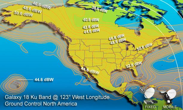
EIRP – dWB and Dish Size
Effective isotropic radiated power in the above footprint (measured in dBW decibel watts), the numbers on the footprint above represent the signal strength from the satellite onto the Earth. The higher the dBW, the greater the signal strength. If you have a region with a low dBW level, you may have to use a larger satellite dish to receive the signal.
The Radio (Outdoor Equipment – ODU)
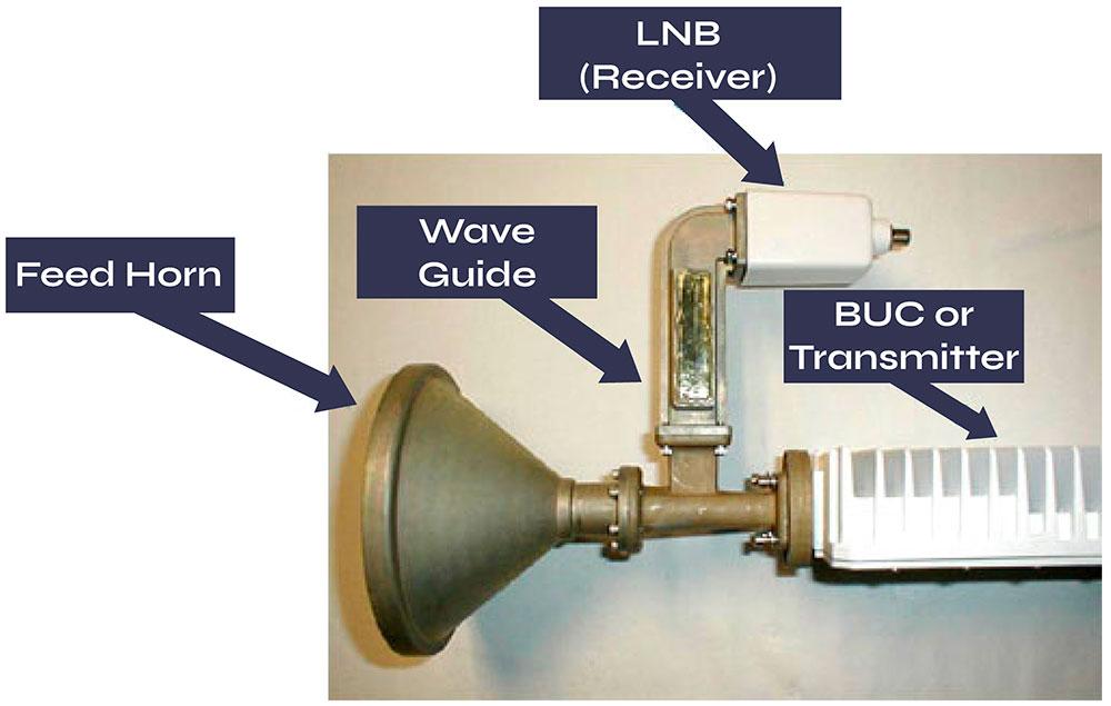
Besides the dish (also called the reflector), what makes up a satellite system is the BUC (pronounced “buck”) which is the transmitter and the LNB receiver. Both require a high performance coax cable connected to the indoor satellite router.
BUCs come in different wattages. The higher the wattage, the greater the satellite system can perform in both speed and in poor environmental conditions. Consumer systems normally use a 1-watt BUC. Ground Control uses a 6-watt BUC with most systems.
The Ku-Band
Satellite communications are radio transmissions in the Ku-band of the electromagnetic spectrum. The Ku-band is the same band that police officers use for their radar detectors. The transmission frequency for Ku-band satellite dishes is typically between 14000 and 14500MHz, while the receiving frequency range is between 11700 and 12750MHz. In addition to the Ku-band, other commonly used satellite bands include the L-band, which is used for IoT and tracking devices, satellite phones, and portable terminals; the C-band, which employs large satellite dishes; and the Ka-band, which utilises smaller satellite dishes.
The Satellite Router or Satellite Gateway
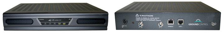
Some Ground Control services use iDirect satellite routers. This is the where the coax cables from the satellite dish connect to inside a building, and where a LAN (local area network) can connect to the internet. Note the Ethernet port on the back of the modem.

Would you like to know more?
For existing Ground Control customers who require technical assistance with their satellite internet solution, please feel free to contact us at help@groundcontrol.com and we will be more than happy to assist you.
If you are interested in exploring satellite internet solutions for personal or business use and want to learn more about Ground Control’s satellite internet services, you can get in touch with us by calling, emailing or completing the form provided on our website. Our team will be happy to answer your queries and provide you with all the information you need to make an informed decision.