Modern military, aviation, and maritime operations are critically dependent on precise Positioning, Navigation, and Timing (PNT) data. For decades, the Global Positioning System (GPS) and other Global Navigation Satellite Systems (GNSS) have served as the backbone of these capabilities, enabling everything from aircraft navigation and drone guidance to vessel tracking and synchronized global communications. However, as GPS denial and deception events become more frequent and geographically widespread, the need for resilient, assured PNT (A-PNT) solutions has become urgent. Ensuring operational continuity requires a clear understanding of the causes of GNSS disruption, who is most affected, how navigation can be sustained without it, and how technologies such as A-PNT can provide protection and redundancy.
The following GPS/GNSS-denial questions outline the key dimensions of this challenge: the sources of GPS disruption, the sectors and regions most exposed, operational fallback procedures, and the A-PNT technologies and strategies designed to safeguard navigation and timing in an increasingly contested GPS environment.
Q1. What Causes GPS Disruption?
Disruption can arise from unintentional interference, deliberate hostile actions, or natural environmental factors; all of which can degrade, deny, or corrupt the signal in ways that directly impact mission assurance and operational safety.
Unintentional interference remains a common source of disruption, particularly in congested environments, like major shipping ports, airspace hubs, and coastal regions. Overpowered or poorly shielded radio frequency transmitters, such as cellular base stations, radar systems, or satellite uplinks, can unintentionally saturate or desensitize GNSS receivers. Faulty amplifiers, including “personal privacy devices” (PPDs) used illegally in vehicles to block tracking, also generate wideband noise that can overwhelm nearby receivers.
Intentional interference, including jamming and spoofing, poses a more severe and rapidly escalating threat. In the military domain, jamming may occur during electronic warfare or combat operations. Criminal organizations also exploit GPS and GNSS vulnerabilities for illicit purposes such as cargo theft, illegal fishing, or sanctions evasion using low cost jammers and spoofers to conceal location or manipulate tracking data. In aviation and maritime operations, such interference can mislead autopilot systems, distort route data, and undermine collision avoidance and surveillance systems like ADS-B and AIS, potentially leading to incidents that pose a threat to life.
Environmental and natural factors further complicate GPS reliability. Solar flares and ionospheric disturbances can alter signal transmission, particularly at high latitudes or during periods of intense space weather, resulting in signal delays or complete loss of lock. Multipath reflections from large metallic structures, such as port cranes, vessel superstructures, or urban skyscrapers, can also distort signals and create false positional data. These effects are particularly acute in confined environments like harbors or dense airspace corridors, where reflected signals can be mistaken for valid GPS information.
Detection and characterization of GPS/GNSS disruption requires a combination of technical and procedural measures. RF power monitoring and direction finding equipment can help locate the source of interference, while incident mapping and space weather alerts support broader situational awareness. Crowdsourced interference reporting and data sharing between civil and military authorities enhance detection coverage and enable trend analysis across regions.
Q2. Who is Most Affected, and Where?
GPS and GNSS disruption has a disproportionate impact on sectors that rely on precise navigation and timing. In aviation, aircraft operating near conflict zones or at high latitudes are particularly vulnerable, with disruptions threatening precision approaches and timing synchronization. In the maritime sector, interference often concentrates along high risk regions with geopolitical tensions, including the Black Sea, Baltic, Eastern Mediterranean, and Persian Gulf – areas where dynamic positioning systems rely heavily on GPS and GNSS inputs.
In aviation, large airliners, business jets, and unmanned systems operating near conflict zones or at polar latitudes are especially exposed. In those corridors, loss or distortion of GPS during approaches or in cruise phases can degrade precision approach capabilities and force reliance on limited backup navigation systems. The aviation industry has already documented multiple spoofing and jamming events, with airlines reporting up to 1,500 daily spoofing incidents in airspace near hotspots like Israel, Lebanon, and Russia by August last year. In some cases, flights have been diverted or prevented from operating safely when GPS was degraded, and civilian aircraft have even been misled toward foreign airspace boundaries by spoofed signals in the Middle East.
In the maritime domain, the impact is acute along major shipping corridors and in regions already identified as interference hotspots. The Black Sea and Baltic Sea remain among the earliest and most persistent trouble zones, but interference has now spread to the Eastern Mediterranean, Persian Gulf, Red Sea, and other high traffic zones. In the second quarter of 2025, GPSPATRON reported that more than 10,000 vessels were affected by GNSS interference – an eightfold increase compared with the previous quarter. The report highlights both a real escalation in jamming and spoofing activity and an improvement in reporting systems across the maritime domain.
From a geographic perspective, “urban canyon” environments – major cities like London, Shanghai, Los Angeles – face a different, localized risk: multipath distortion and spoofing attempts exploiting signal reflections. In addition, there has been an uptick in inland interference reports, especially near major airports and ports, which has been attributed to illicit jammers in vehicles or on-ground emitters aiming to mask tracking.
Through enhanced incident reporting and sharing to understand which domains, vessels, aircraft, and infrastructure are most at risk, and where interference is currently the most concentrated, decision makers can prioritize surveillance assets, including radio frequency monitors, and deploy resilient PNT systems in high risk zones first, where vulnerability is highest.
Q3. How do Pilots, Mariners, and Military Personnel Navigate Without GPS?
In aviation, when GPS is unavailable, aircraft revert to more traditional navigation systems and navigation aids that must be maintained as essential backups. The backbone is the Inertial Reference System (IRS) and Inertial Navigation System (INS), which uses accelerometers and gyroscopes to continuously estimate position, velocity, and attitude. However, inertial systems suffer from drift – small sensor errors accumulate over time. To constrain that drift, pilots use periodic corrections from ground-based radio aids such as DME (Distance Measuring Equipment), VOR (VHF Omnidirectional Range), or radar updates from Air Traffic Control. When GPS integrity is lost, pilots may revert to conventional airways and non-GNSS instrument procedures, fly under visual flight rules if weather allows, or rely on approaches guided by the Instrument Landing System (ILS), NDB (Non-Directional Beacon), or local ground-based navigation aids. The FAA explicitly retains a VOR MON (Minimum Operational Network) concept to ensure aircraft can navigate via conventional VOR paths during GPS outages.
In maritime and offshore operations, GNSS denial is a severe vulnerability, particularly for dynamic positioning vessels and precise stationkeeping tasks, so ships rely on a suite of fallback systems. A gyrocompass, Doppler log, and radar-bearing fixes provide coarse navigation and heading references in coastal waters. Electronic Chart Display and Information Systems (ECDIS) allow manual plotting of fixes, and in more extended open ocean transits, celestial navigation or celestial fixes remain usable (albeit with skill). Some operators are evaluating the revival of terrestrial radio systems like eLORAN, which transmit low frequency signals over land that are much harder to jam and can serve as a GNSS backup in restricted regions.
For military operations in contested or GPS-denied environments, reliance on GNSS is particularly fragile, so hybrid navigation is essential. The U.S. Army has actively pursued pseudolite networks (ground-based “pseudo-satellites”) to preserve position information when GPS is denied. Pseudolites broadcast local ranging signals that, when integrated with an INS, give troops a reliable local positioning layer with far higher received power than spaceborne signals and therefore much better resistance to jamming at the tactical scale.
These alternative methods, however, are not without vulnerabilities or trade-offs. Inertial systems drift and must be regularly corrected; radio aids can be jammed, degraded, or decommissioned, vision-based systems fail in low visibility or featureless terrain, and acoustic or pseudolite systems have limited coverage or require infrastructure. This is why cross-training crews in traditional navigation techniques, sensor fusion architectures, and frequent calibration of INS and navigation sensors remains essential. Maintaining up to date navigation charts, ground aids, and fallback databases all help to ensure operational continuity when GNSS is degraded or denied.
Q4. What’s A-PNT, and How Does it Compare to GPS?

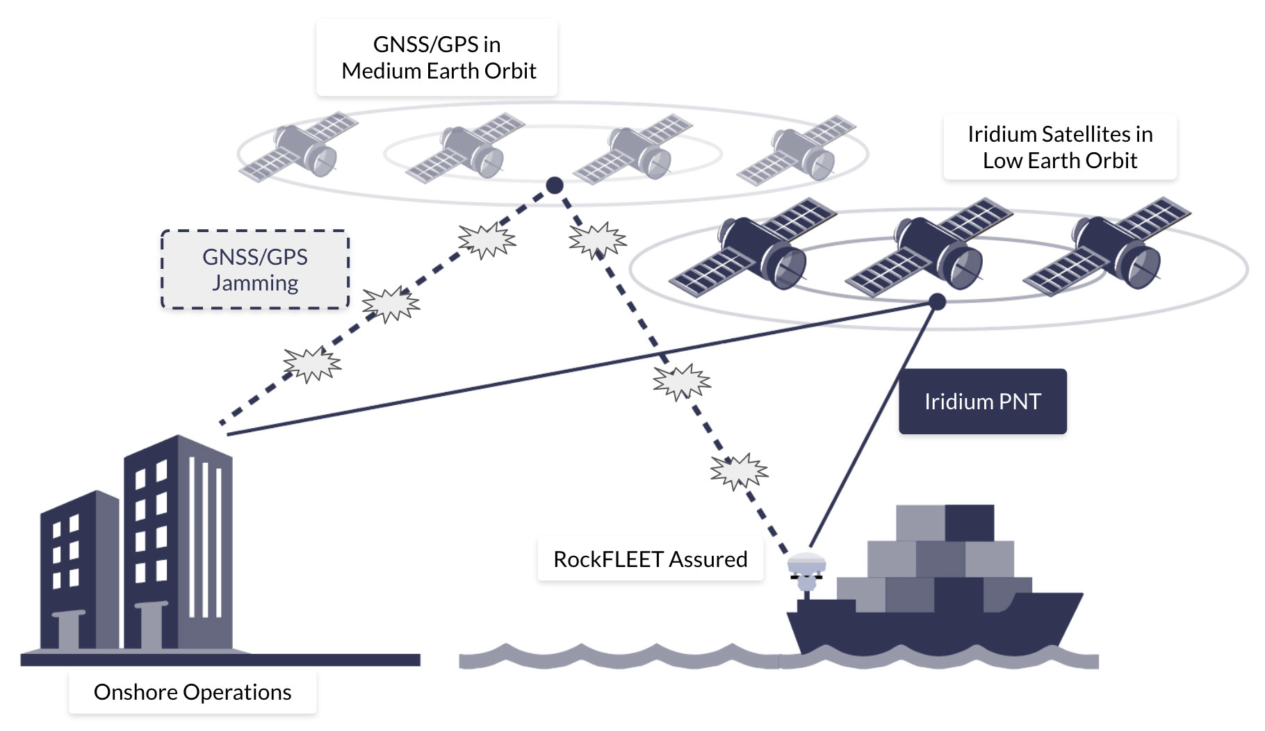
GPS and GNSS signals originate from satellites orbiting over 20,000 kilometers above Earth (in Medium Earth Orbit). The signals received at ground level are weaker, more easily disrupted or imitated by stronger, locally generated transmissions. A-PNT is designed to provide resilient, assured PNT when GPS or other GNSS signals are degraded, denied, or spoofed. GPS, while globally available and highly accurate under nominal conditions, is inherently vulnerable because its space-based signals are extremely weak and susceptible to jamming, spoofing, or interference from natural and environmental factors.
Iridium’s Positioning, Navigation and Timing service, Iridium PNT, is made up of a constellation of 66 Low Earth Orbit (LEO) satellites, which provide overlapping global coverage, including the polar regions. Unlike GNSS satellites in Medium Earth Orbit (MEO), Iridium satellites transmit PNT signals that are approximately 1,000 times stronger than GPS signals, making A-PNT particularly valuable in urban canyons, indoor environments, and other challenging conditions where GNSS signals may be obstructed.
Q5. How Is Iridium PNT Improving Navigational Resilience for GPS-denied Territories?
For military and security users, this shift offers critical operational advantages. LEO-PNT services delivered via the Iridium constellation provide encrypted and regionally tailored positioning, navigation, and timing data that can penetrate indoors, under canopy, or through moderate jamming. Iridium’s PNT service leverages Iridium’s 66-satellite global mesh operating in the L-band, distinct from GPS frequencies, making it far harder to disrupt with conventional jamming equipment. Because the Iridium system is already operational and uses cross-linked satellites for global coverage, it provides real time assured timing and location integrity even in contested or denied regions such as the Arctic, the Indo-Pacific, or urban RF-dense zones.
Satellite proximity to the Earth and signal strength alone, however, are not enough to secure PNT. Thus, the Iridium PNT service also incorporates cryptographic authentication to protect against spoofing and tampering. Every navigation and timing message is digitally signed, and receiving devices verify the integrity of those signatures before using the data. Unauthorized or falsified signals are rejected, ensuring that systems operate only on trusted information, delivering a far more robust and resilient service than GPS.
For commercial shipping and aviation, these LEO-based services introduce an accessible layer of resilience. In hybrid navigation, Iridium PNT works alongside GNSS and INS, enabling devices such as RockFLEET Assured to seamlessly shift or blend inputs as signal conditions change. In maritime environments, where GPS spoofing has been documented in the Black Sea and Eastern Mediterranean, Iridium-based A-PNT can sustain dynamic positioning operations. Similarly, aviation operators can use A-PNT to maintain flight management system synchronization and prevent false positional data from compromising navigation displays.
In practice, A-PNT serves as a critical additional layer of navigation for military, maritime, and aviation operations, allowing personnel, aircraft, ships, and unmanned systems to maintain mission continuity when GNSS is compromised. The resilient and secure design of A-PNT provides operational assurance, mitigating the single point vulnerabilities of space-based GNSS and GPS navigation, and is increasingly becoming recognized for resilient navigational planning in both defense and commercial sectors.
Q. 6 Are There Civilian-grade Alternatives to GPS?
Satellite A-PNT (Global, Operational Today)
Iridium’s PNT service is the only commercially available, satellite-delivered A-PNT service today. It rides on Iridium’s cross-linked LEO constellation to deliver robust time and location that complements GNSS and works indoors/urban canyons with much higher received power than MEO GNSS. It’s in service now across critical infrastructure timing and is being integrated with avionics and INS for navigation resilience. In a layered architecture, receivers blend or fail over between GNSS, inertial sensors and Iridium PNT to maintain continuity when GNSS is degraded or spoofed (this behavior is implemented by the receiving system; Iridium PNT is the alternative signal).
More GNSS ≠ an “Alternative,” But it Adds Diversity
Galileo now offers OSNMA (operational since 24 July 2025) to authenticate navigation messages and harden against spoofing. Helpful, but it doesn’t solve jamming or deep attenuation, because it’s still a MEO GNSS signal.
GLONASS, BeiDou, QZSS, NavIC add constellation diversity and regional coverage, improving availability and geometry. They still share core GNSS vulnerabilities (low received power, jamming/occlusion, multipath), so they’re complements, not true A-PNT alternatives. The need for non-GNSS layers is a key theme in recent policy/industry work.
Terrestrial A-PNT (Promising, But Deployment-dependent)
eLoran (LF terrestrial) delivers strong, hard to jam signals and good timing/positioning potential where networks exist. Roll-outs remain national/project-based (e.g., UK market engagement and MOD work on deployable eLoran), so coverage is not yet ubiquitous.
Emerging LEO PNT (Pre-commercial Navigation)
Several startups are flight-testing LEO PNT and demonstrating receivers, but broad commercial navigation services are still in demonstration/early rollout, not widely available to civilians today. They underscore the momentum toward frequency/orbit diversity, but Iridium PNT is the operational option right now.
For civilian users who need assured PNT today, the practical, globally available satellite alternative layer is Iridium’s PNT service, best used in a hybrid stack alongside GNSS and inertial sensors. Additional GNSS constellations and OSNMA improve resilience to spoofing, while eLoran and emerging LEO PNT add promising diversity where deployed, but they don’t replace the need for a satellite A-PNT layer like Iridium PNT in 2025/6.
Q7. What are the Early Warning Signs of GNSS Interference?
Early warning signs of GNSS interference are critical for maintaining operational safety across military, aviation, and maritime platforms. Onboard receivers may show a sudden loss of satellite lock, unexpected position or time jumps, or RAIM/integrity alerts in aircraft, all of which indicate potential jamming or spoofing. Unusually high or low signal-to-noise ratios, discrepancies between redundant receivers, or inconsistencies with INS, radar, Doppler logs, or visual bearings, or an Iridium PNT feed, are additional red flags.
In hybrid GNSS + INS + Iridium PNT architectures, the system can continuously compare GNSS against Iridium PNT’s independent time/location. Divergence beyond thresholds, for example, GNSS position drifting while STL-referenced dead reckoning and ship sensors remain coherent, provides early, positive indication of spoofing or severe degradation, enabling alarms, de-weighting of GNSS, or automatic failover/blending to maintain navigation continuity.
At the system level, automated controls may generate alerts: aircraft autopilots or ship dynamic positioning systems may show deviations from expected performance without an apparent environmental cause. Slowly drifting positions or erratic movements that do not match the platform’s true course may suggest spoofing rather than outright jamming. Environmental indicators, such as unusual RF activity in GNSS frequency bands or corroborating reports from nearby vessels or aircraft, can confirm the presence of interference.
Q8. What are the Operational Detection and Reporting Practices?
GNSS interference is usually first detected by anomalies in receiver behavior, a sudden loss of lock, abrupt jumps in reported position or time, unexplained offsets between redundant receivers and inconsistent cross-checks such as mismatches in radar or visual bearings. Passive indicators include a degraded number of satellites, rising noise floor on GNSS receivers, and unusual changes in signal-to-noise ratio. Spectrum analyzers or dedicated GNSS interference detectors will also show elevated power in GNSS bands or narrowband/discrete emitters.
For commercial ships and offshore platforms, once GPS and GNSS denial, jamming, or spoofing is detected, immediate shipboard actions should include switching to alternative position references, alerting the master and company operations center, logging precise UTC times and system messages, and retaining raw GNSS logs for later analysis. Reports must be made immediately to the national coastguard, port authorities and, where relevant, the NATO Shipping Center or regional maritime security centers. International bodies have urged states to set up reporting processes and share incident information to build enhanced situational awareness of GPS and GNSS jamming incidents.
Crews and air traffic control in civil aviation must treat suspected GNSS anomalies as safety events. Typical detection triggers are RAIM failures, unexpected position/time jumps, or receivers losing satellites simultaneously. Immediate mitigations include notifying Air Traffic Control, switching to approved non-GNSS procedures and filing a formal GPS Anomaly Report to the aviation authority. Regulators recommend issuing NOTAMs quickly once interference is corroborated and coordinating regionally to warn other operators.
Military units operate under additional communication constraints but follow similar practical steps. Military reporting prioritizes rapid attribution and countermeasures, but civil and military coordination is critical when interference affects commercial traffic or national infrastructure. NATO and national EW authorities, therefore, maintain liaison procedures to escalate cross-domain incidents. Parliamentary and defense briefings recommend documenting events and sharing forensic data while preserving operational security.
Good reporting practice in all domains requires preserving evidence and providing standardized data. Centralized incident submissions allow pattern analysis and help regulators issue area-wide warnings. Crowdsourced detection projects and academic anomaly detection tools can supplement official channels and speed community awareness.
In Summary
The vulnerabilities of GPS and GNSS represent a critical operational risk across military, aviation, and maritime domains. Their inherently weak signals are easily disrupted by intentional jamming, spoofing, or even natural phenomena such as solar flares and ionospheric disturbances. Real world incidents from the Black Sea to the Eastern Mediterranean and Arctic corridors have repeatedly demonstrated that overreliance on GNSS can jeopardize mission integrity, navigational safety, and the continuity of operations. To mitigate these threats, both defense forces and commercial operators should invest in A-PNT to further strengthen resilience by providing high-power, encrypted, and timing and positioning data.
The strategic imperative is clear: GNSS dependence must evolve toward a multi-layered ecosystem, integrating terrestrial and PNT technologies, procedural training, and robust reporting chains. For decision makers in defense, aviation, and commercial shipping, building resilience into PNT infrastructure has become an operational necessity for maintaining control, safety, and strategic advantage in an increasingly contested environment.

Any more questions?
If you didn’t find the answer you were looking for, or if you’d like to discuss how A-PNT could enhance your GPS and GNSS architecture, our team is here to help.
Simply fill out the form, and one of our experts will get back to you to talk through your requirements, explore the solutions, and help you plan your next steps.
Whether you’re just starting to explore A-PNT or are ready to move ahead with an A-PNT solution, we’ll work with you to find the right device for your application.