When winter bites, the world doesn’t stop moving. Researchers crunch climate data at 6,500 meters. Ships weave through drifting icebergs. Volunteers groom snowmobile trails through the night. Pilots fly over whiteout terrain. Rivers swell with snowmelt and threaten nearby communities.
In all of these places, terrestrial connectivity is patchy, or simply doesn’t exist. From Himalayan glaciers to Arctic sea ice and winter trails, Ground Control’s satellite IoT and tracking services keep people, assets and data connected when the temperature drops and terrestrial networks disappear.
We’ve brought together five real world winter operations where satellite IoT quietly gets the job done.
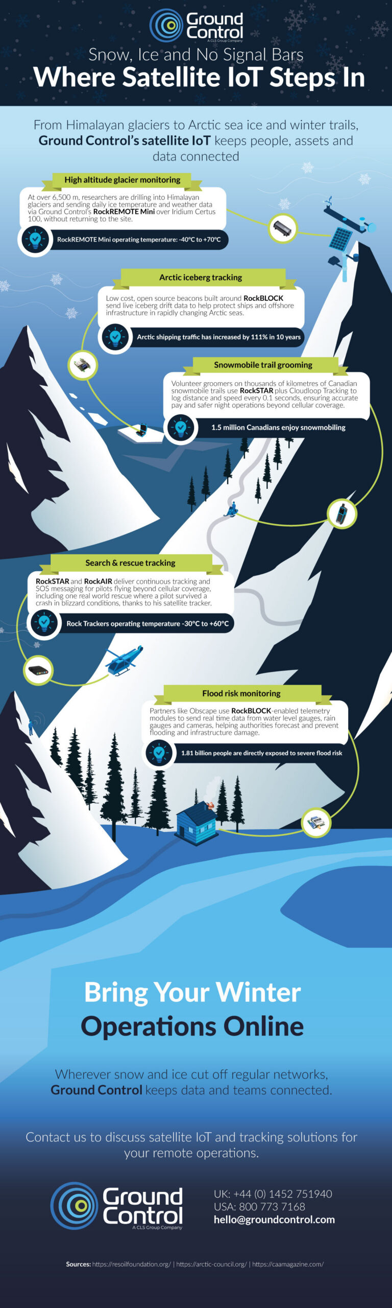
High Altitude Glacier Monitoring on Everest
At extreme elevations, there are no engineers on call, no cell towers on the skyline, and not much margin for error. Yet these are exactly the locations where climate scientists need reliable, continuous data.
On Himalayan glaciers, researchers are deploying autonomous stations that can operate for months at a time without human intervention.
Using Ground Control’s RockREMOTE Mini over the Iridium Certus 100 network, these stations send back daily information on ice temperature and local weather conditions.
That data helps scientists understand how fast glaciers are melting, how conditions are changing over time, and what that means for the communities that rely on these frozen reservoirs downstream.
Arctic Iceberg Tracking for Safer Seas
In the Arctic, winter never really leaves, and the landscape is in constant motion. Icebergs calve from glaciers and drift through busy shipping lanes and past critical offshore infrastructure. For vessels and platforms operating in these waters, knowing where the ice is, and where it’s heading, is essential.
Teams working in this environment are deploying low cost, open source beacons built around Ground Control’s RockBLOCK technology.
These compact devices are attached to icebergs and send regular position updates via satellite as the ice drifts. Operations teams use that data to build drift models, refine routes and maintain safe stand off distances from moving ice.
Snowmobile Trail Grooming Beyond Cellular Coverage
Further south, in dense forests and mountain passes, a different winter challenge unfolds. Snowmobile clubs rely on volunteer groomers to keep thousands of kilometers of trails in good condition, often working late into the night and far from any cellular signal.
To support these teams, clubs are equipping groomers with RockSTAR devices linked to Ground Control’s Cloudloop Tracking platform. As the groomers work, their position, distance travelled and speed are automatically logged.
This creates an accurate record of grooming activity that can be used for fair reimbursement and better planning, and it also provides real time visibility of where machines and operators are.
Search and Rescue Tracking in Winter Skies
When something goes wrong in winter, it can escalate quickly. For pilots flying over snowy valleys, mountain ridges and frozen lakes, situational awareness and communication are non-negotiable. Whiteout conditions, icing and rapidly changing weather can all conspire to make navigation and emergency response more difficult.
RockSTAR and RockAIR devices from Ground Control provide continuous satellite tracking and two-way messaging for aircraft operating beyond cellular coverage.
Each flight can be monitored in real time on a map, giving operations teams a clear picture of where aircraft are and how their routes are progressing. If the worst happens, SOS capabilities allow pilots to raise an alert and share their location, even when other communications have failed.
In one real world rescue, a pilot survived a crash in blizzard conditions and was located thanks to his satellite tracker, which continued to transmit his position. It’s a powerful illustration of how a small, rugged device can make a critical difference when conditions are at their most unforgiving.
Flood Risk Monitoring When Snow Turns to Floodwater
As temperatures rise, water from snow and ice makes its way into rivers, culverts and drainage systems, sometimes overwhelming infrastructure and threatening nearby homes and businesses. Being able to monitor these systems in real time is key to managing flood risk.
Partners like Obscape use RockBLOCK-enabled telemetry modules to connect water level gauges, rain gauges and cameras, even in remote or hard to reach locations.
These instruments send back frequent measurements and imagery via satellite, giving authorities and engineers an up to date view of catchment conditions. When indicators reach critical levels, teams can act quickly, whether that’s issuing warnings, closing roads, or checking vulnerable assets.
Because the connection does not rely on terrestrial networks, the system continues to function during storms and power outages, providing a resilient backbone for early warning and response.
Bring Your Winter Operations Online
Wherever snow and ice cut off regular networks, Ground Control keeps data and teams connected. From glacier monitoring and iceberg tracking to snowmobile trail grooming, aviation safety and flood risk management, satellite IoT ensures that critical information continues to flow, even when your signal bars vanish.
If your operations take you beyond cellular coverage, satellite connectivity doesn’t need to be complex or out of reach. Ground Control’s hardware, airtime and management platforms are designed to work together, so you can focus on outcomes rather than infrastructure.

Helping you stay connected
If your winter operations take you off the beaten track, we can help you stay connected.
Complete the form, or email hello@groundcontrol.com and we’ll reply within one working day, connecting you with a team with over 20′ years experience of extracting data from the most remote places on Earth.