Unmanned aerial vehicles are no longer confined to the pilot’s line of sight. Today’s drone programs, from infrastructure inspection across deserts to search and rescue in the Arctic, depend on rock solid, global data links. Satellite connectivity has gone from “nice to have” to mission critical, but integrating it brings a fresh set of challenges: regulatory approvals for BVLOS, SWaP trade-offs inside a tiny airframe, keeping latency low for real time piloting, and building in fail-safe handovers when the sky gets crowded.
In this guide, we tackle the questions drone manufacturers ask most often. We’ll show you how to:
- Prove your link reliability for Beyond Visual Line Of Sight flights
- Choose and integrate a compact, power efficient satellite modem without busting your weight budget
- Optimize latency and throughput so your command links stay sharp
- Understand cost structures and usage patterns to build a viable business case.
Click on the above links to jump straight to your top concern, or read straight through for an end-to-end blueprint. Let’s get you connected.
Q: What Makes BVLOS so Challenging, and How Can Satellite Connectivity Help?
A: Flying Beyond Visual Line of Sight (BVLOS) introduces several core challenges which satellite connectivity can help mitigate using commercially available, aviation-tested technologies. The insights below draw on findings from Iridium’s excellent white paper, Monitored BVLOS Operations & Safe Separation, which we highly recommend reading in full.
1. Detect and Avoid (DAA)
Challenge: Drones must detect and steer clear of nearby aircraft, especially in non-segregated airspace.
Satellite role: By integrating Commercial Off-the-Shelf (COTS) avionics such as ADS-B In, and using satellite communications to deliver traffic data to the RPIC, operators can enhance situational awareness and support onboard or ground-based DAA strategies, even in regions with no ground infrastructure.
2. Reliable Command & Control (C2)
Challenge: Maintaining a robust, real-time command link is critical, but VHF is unavailable in remote areas and LTE coverage is patchy.
Satellite role: Iridium L-band communication links deliver consistent, uninterrupted C2 performance, even in remote and hostile environments where terrestrial networks fail. In test flights, satellite C2 links proved more reliable and continuous than LTE. Aircraft with dual independent L-band satcom systems also gain redundancy, ensuring control is maintained even if one link fails.
3. Communication with Air Traffic Control (ATC) and Other Aircraft
Challenge: Drones operating in controlled airspace still need to maintain communication with ATC and be aware of other traffic, even without VHF.
Satellite role: COTS satcom solutions can be used to maintain communication between RPICs and ATC where ground-based VHF isn’t an option. Integrating technologies such as ADS-B In and Out over satellite provides RPICs with the same traffic visibility expected of crewed IFR flights.
4. Regulatory and Certification Barriers
Challenge: Aircraft type certification processes were built for decades-long product cycles, not fast-evolving drone platforms. A 36 month certification timeline often means that core systems (e.g. batteries, avionics) are outdated by the time certification is complete.
Satellite role: While waiting for certification frameworks to catch up, drone operators can pursue BVLOS waivers for specific missions. Embedding a standardized Minimum Equipment List (MEL) of proven, COTS avionics and satcom hardware strengthens the case for safe, monitored BVLOS operations and supports a more scalable path toward regulatory approval.
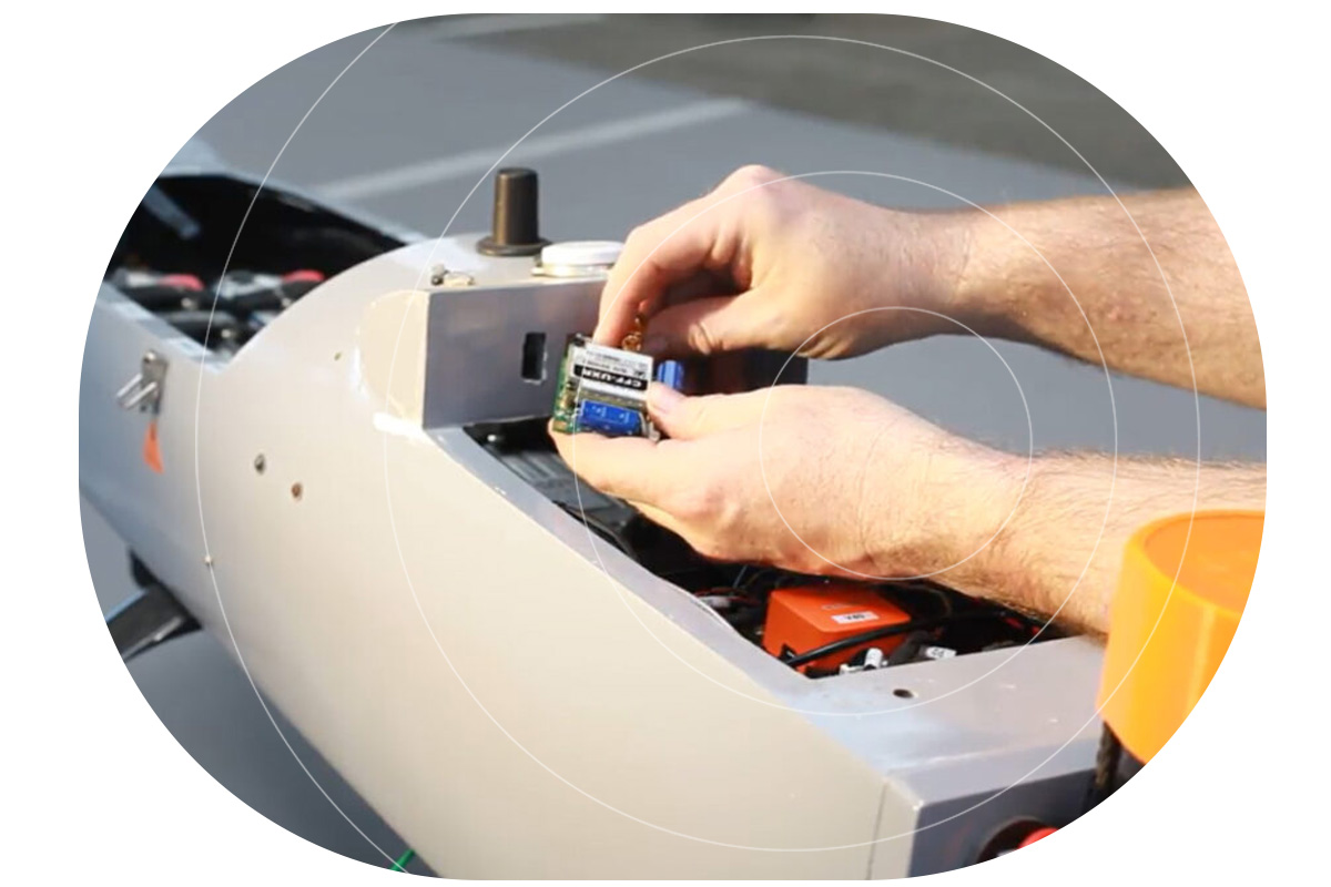
Q: How Can I Integrate Satellite Connectivity Into My Drone Without Compromising on Size, Weight, or Power?
A: Thanks to ongoing improvements in satellite IoT hardware, it’s now possible to integrate satellite connectivity into a drone without breaking your SWaP budget, but there are trade-offs. Smaller, lighter, message-based modules like RockBLOCK 9603 and 9704 are ideal for sending telemetry or basic commands with minimal power draw. However, if your application demands real-time command and control, you’ll need a larger, IP-capable device like the RockREMOTE UAV OEM, which delivers more functionality, but at a higher cost in power and space.
1. Managing the SWaP Budget for Satellite Modules
Fortunately for UAV manufacturers, satellite IoT modules have been on a smaller, lighter, lower-power draw trajectory for several years, so it’s not usually difficult to find a module that will fit into your enclosure. Our most popular device is the RockBLOCK 9603, weighing just 36 g (1.27 oz) and measuring 45 x 45 x 15 mm. This incorporates a patch antenna, but because it usually sits within a metal enclosure, an external antenna is often deployed.
However, there are trade-offs between module size and capability. RockBLOCK 9603 utilizes Iridium’s Short Burst Data service (SBD), which is suitable for some drone applications, but not all.
It works well as a failover means of communication in the event that the primary means of communciation (usually radio) drops; to transmit the drone’s position, altitude and speed, and to issue basic commands (go to the nearest rally point; go home; terminate flight etc.).
If you simply need to send more data – for example, compressed images or multiple sensor readings – RockBLOCK 9704, which utilizes Iridium Messaging Transport (IMT), delivers much larger data packets, and is similarly small and light (35 g / 48 x 52 x 16 mm for the SMA – external antenna – option).
Both of these solutions are message-based, however, which makes them less suited to real-time command and control of your UAV. For this purpose you need an IP-based transmission, and that means both a larger device, which draws more power.
2. Trade-Offs Between Module Size, Transmit Power, and Battery Life
An IP-based connection enables near real-time communication, making it ideal for applications like command and control, or remote diagnostics. However, this comes at a cost: IP-based modules require more processing power, memory, and a more complex operating system, which increases both size and power consumption. They also transmit higher volumes of data, which typically requires more energy per transmission.
Our recommended hardware for an IP-based connection is RockREMOTE UAV OEM, as this utilizes both the Iridium Certus 100 airtime service, running at 22/88 Kbps, and Iridium Messaging Transport, giving you the option to save power and potentially costs by transmitting some data in a packet format, and reserving the IP connection for real-time applications. It’s also one of, if not *the*, smallest and lightest options for UAV IP communication.
Q: How do I Manage Latency When Designing Satellite Connectivity for Drones?
A: LEO satellites offer low latency – typically 0.5 – 1.5 seconds for IP-based services – making them ideal for real time drone control, while message-based protocols (around 10 seconds latency) are better suited to delay-tolerant data like location or telemetry. GEO satellites add more delay due to distance, but can still be effective for non-urgent communications.
Latency – the time it takes for your data to do the trip from your drone to your application – is chiefly governed by the satellite orbit height. Simply, the further away from Earth the orbit, the longer the latency. Satellite networks in Low Earth Orbit (LEO), including Iridium and Starlink, are between 160 and 2,000 km above Earth, and the typical round-trip latency for an IP-based service like Iridium Certus 100 is between 500 – 1,500 milliseconds (0.5 – 1.5 seconds). This makes LEO services ideal for time-sensitive operations like piloting or real time alerts.
It’s worth noting that LEO round-trip latency is longer for a message-based service – around 10 seconds – because the message is queued, then forwarded to a ground station, vs. an always-on transmission model. So, for drone applications, message-based protocols are better suited to delay-tolerant applications (location, altitude, speed; basic commands; failover comms), reserving IP-based connectivity for real time command and control, or live diagnostics.
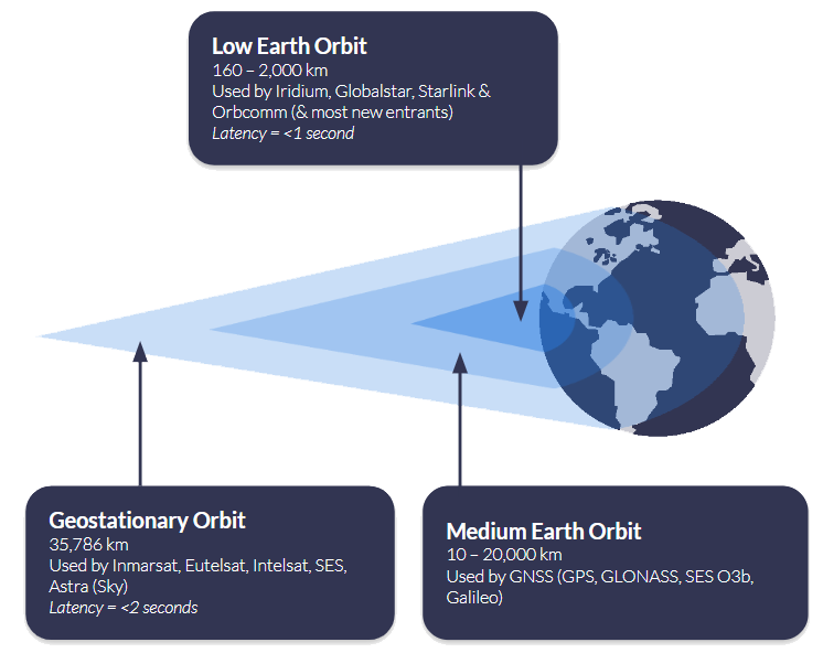
Satellites in Geostationary Orbit (GEO) are 35,786 km above Earth; because they’re so much further away, they can ‘see’ much more of the Earth’s surface, so fewer satellites are needed to provide wide coverage. The latency is longer – c. 2 seconds for an IP-based connection such as Viasat IoT Pro, and longer for a message-based solution such as Viasat IoT Nano – because the data has to travel further. However, if you can bake in some latency tolerance into your application, or simply reserve this means of communication for less time-sensitive telemetry, this offers an economical and often very stable means of communication.
Q: Is Satellite Connectivity Financially Viable for Drone Operations?
A: Satellite airtime can be tailored to match drone usage patterns and fleet scale, using flexible subscription models with clear pricing. For many drone operators, particularly those flying BVLOS or in low connectivity areas, satellite becomes cost effective with just 10 – 20 flight hours per month, especially when uptime is mission critical.
Flexible Subscription Models
Recognising that unmanned applications like drones are a key growth market, satellite network operators like Iridium offer increasingly diversified options for airtime. Ground Control, as a long-term Iridium partner, can offer UAV manufacturers and users monthly subscriptions, pay‑as‑you‑go, or annual commitments – all with transparent pricing and volume discounts for larger operations. Operators using existing Certus 100-compatible hardware can activate airtime instantly through Ground Control, simplifying deployment.
When Does Satcom Pay Off?
Although detailed cost breakdowns vary by mission profile, satellite connectivity often becomes cost effective at a relatively modest flight tempo. If your missions involve command/control, telemetry, or operations beyond cellular coverage, satellite ensures reliability that terrestrial networks can’t guarantee. With real time capabilities over Iridium Certus 100 and competitive airtime pricing, operational risk reduction often justifies the cost within 10 – 20 flight hours per month.

Connecting Drones Beyond Terrestrial Coverage
Satellite connectivity makes it possible to operate UAVs far beyond the reach of terrestrial networks, but integrating it requires thoughtful design. From managing size, weight and power to understanding latency, throughput and cost, this post outlines the key considerations for adding satcom to your drone system.
If you’re developing a satcom-enabled drone, our team can help you find the right hardware and airtime for your mission. Email hello@groundcontrol.com or complete the form, and we’ll be in touch within one working day.