RockDASH
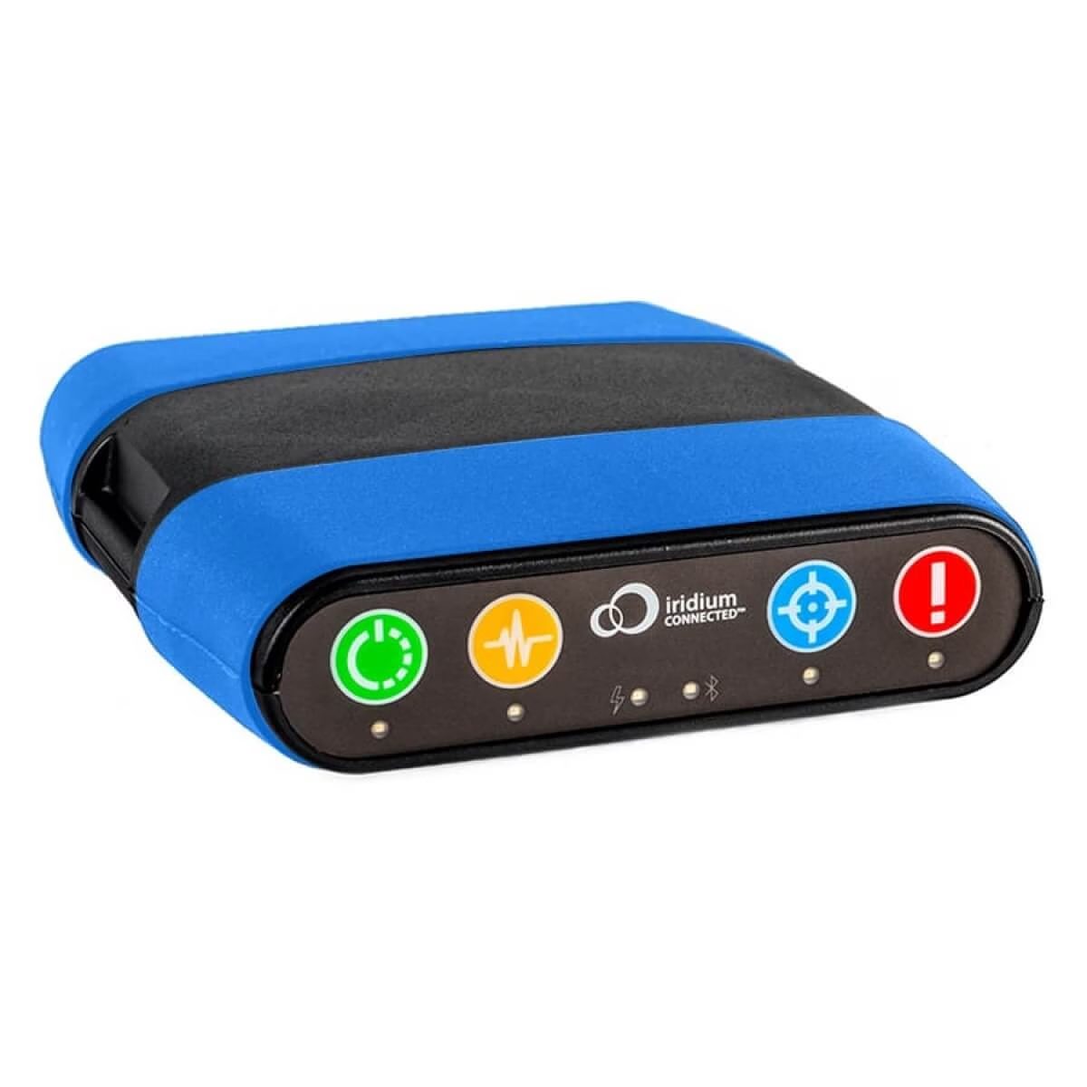
RockDASH is a dash mounted vehicle tracking and messaging device for fleets operating in remote or low cellular coverage areas. It uses LTE Cat M1 connectivity where available and automatically switches to the global Iridium satellite network when needed, helping teams maintain vehicle visibility and communication beyond reliable mobile coverage.
Key Features
Track vehicles and mobile assets, support remote workers and respond quickly when journeys move beyond reliable cellular coverage.
Protect Vehicles and Remote Teams
Track vehicle location, request closer monitoring and send an alert with a precise position when drivers or field teams need support.

Connected Beyond Cellular Coverage
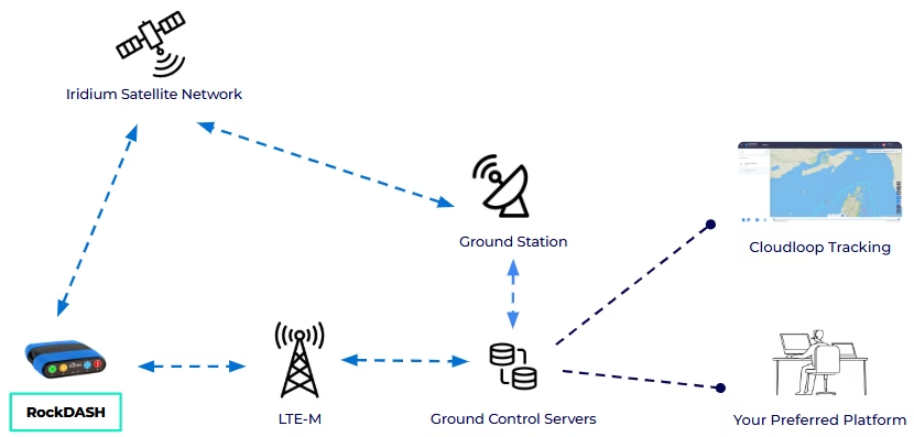
RockDASH uses LTE Cat M1 where available and switches automatically to Iridium to maintain tracking and messaging in remote areas.
Simple to Install and Operate
The compact dashboard unit uses a quick-release mount and straightforward controls, making it easy to install, operate and transfer between vehicles.
Monitor More Than Location
Connect onboard sensors through five switch inputs or the RS-232 interface to monitor conditions such as temperature, vibration, pressure or access events alongside vehicle position.
How It Works
When you cannot afford to lose sight of vehicles, cargo or remote teams, RockDASH keeps location data and messages moving across changing coverage conditions. It uses LTE Cat M1 where available and switches automatically to the Iridium satellite network when cellular coverage drops.
Quick to install and simple to manage, RockDASH sends tracking updates, alerts and messages to your chosen platform. Use it with your existing systems or connect through Ground Control’s tracking tools for a ready-to-use setup.
Use Cloudloop Tracking
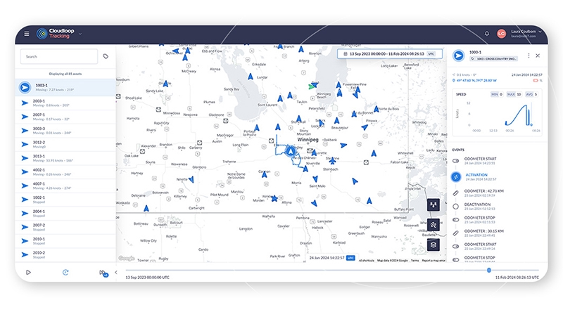
Cloudloop Tracking gives smaller fleets a straightforward way to monitor vehicles, cargo and remote teams without building a separate tracking platform. View RockDASH location data, routes and alerts securely from desktop or mobile.
- View current vehicle locations and movement history
- Create geofences with alerts on entry, exit or both
- Adjust tracking intervals and behaviour for different operating areas
- Use watch mode to identify unusual activity
- Send pre-programmed Red Alert notifications when support is needed
- Exchange short two-way messages through the RockCONNECT app
Why Choose RockDASH?

Global Satellite Tracking
RockDASH uses Iridium SBD to transmit location updates, alerts and messages from remote routes, maintaining visibility when LTE Cat M1 coverage is unavailable.
Quick to install and move
Its compact design and quick release mount make RockDASH easy to install and transfer between vehicles.

Reliable messaging beyond mobile coverage
Paired with a Bluetooth device and the RockCONNECT app, RockDASH supports two way messaging when cellular service is unavailable.
Control connectivity costs
RockDASH uses cellular connectivity where possible and switches to satellite only when needed, balancing coverage with operating cost.
Flexible geofencing and alerts
Create custom operating areas, trigger alerts on entry or exit, and adjust tracking behaviour based on vehicle location.
Connect to onboard systems
Use the external switch inputs and RS-232 interface to send data from connected sensors or vehicle equipment alongside tracking information.
Resilient power options
Power RockDASH from a vehicle supply or USB, with an internal backup battery helping maintain tracking if external power is interrupted.
Works with your preferred platform
Use RockDASH with Cloudloop Tracking, or your own tracking software through Ground Control APIs.
Commercial and Mixed Fleets
Construction, Utilities and Field Services
Remote Logistics and Delivery
NGOs and Humanitarian Organisations
Equipment and Mobile Asset Security
Product Specifications
Communications
- Satellite Service
- Iridium Short Burst Data (SBD)
- Cellular Service
- LTE Cat M1 (LTE-M)
- Network Switching
- Uses LTE Cat M1 where available and automatically switches to Iridium when cellular connectivity is unavailable
- Satellite Coverage
- Global Iridium network coverage
- Two Way Messaging
- Supported through Bluetooth LE and the RockCONNECT app using a compatible smartphone or tablet. Messaging availability depends on the connected platform and service configuration.
- Message Delivery
- Messages can be delivered by email or sent to a customer web service
- Satellite Message Size
- Up to 340 bytes sent and 270 bytes received
- Tracking Frequency
- Configurable from every 15 seconds to once every 24 hours
- Tracking Profiles
- Different reporting rates and behaviours can be configured for cellular and satellite coverage, movement, geofenced areas, power status and alert conditions
Tracking and Safety
- Positioning
- Integrated GPS/GNSS positioning
- Watch Mode
- Requests closer monitoring for a defined period. How activity is monitored and escalated depends on the connected tracking platform
- Red Alert
- Sends a pre-programmed alert with the device’s precise position and switches the tracker to its configured distress reporting profile
- Waypoint Marking
- Supports unlimited waypoints across up to four user-defined categories
- Geofencing
- Supports location based reporting profiles and entry or exit behavior
- Activity Sensing
- Uses positioning and accelerometer data to detect movement and automatically change tracking behaviour
- Automatic Alerts
- Supports alerts for power changes, temperature thresholds, impacts or collisions, movement and events received through the digital inputs
- Onboard Logging
- Records position and diagnostic data to a MicroSD card for later review
- Integrated Sensors
- GNSS, accelerometer, thermometer, power-loss and impact sensors
Physical and Environmental
- Dimensions
- 100 × 119 × 25 mm (3.94 × 4.69 × 0.98 in)
- Device Weight
- 210 g (7.4 oz)
- Installation
- Quick-release mounting clip, with visible or covert in-vehicle mounting options
- Operating Temperature
- -30°C to +60°C (-22°F to +140°F)
- Operating Humidity
- Below 75% relative humidity
- Storage Temperature
- -40°C to +85°C (-40°F to +185°F)
- External Antennas
- Optional Iridium, GNSS and cellular SMA connections
- Regulatory Compliance
- CE and FCC
Electrical
- DC Input
- 8-32 V DC through the Molex connector
- USB Input
- Regulated 5 V through Micro-USB or USB-C
- USB Supply Requirement
- Minimum 1.3 A
- Backup Battery
- Rechargeable 3.7 V, 1,850 mAh lithium-ion polymer battery
- Backup Operation
- Up to eight hours when transmitting once per minute over Iridium
- Battery Charging
- Charges automatically from either supported external power input
Data and Interfaces
- Digital Inputs
- Five switch or alert inputs for events from connected sensors and equipment.
- Serial Interface
- RS-232 transmit and receive interface for connected equipment and custom data
- Bluetooth
- Bluetooth LE connection for compatible smartphones and tablets
- Remote Configuration
- Tracking profiles and key device parameters can be updated remotely
- Data Delivery
- View tracking information through Cloudloop Tracking or deliver data to your own system via APIs
- Cloudloop Tracking
- Supports current and historical position viewing, speed monitoring, event tracking, alert notifications and asset grouping.
- Custom Integrations
- RockDASH tracking and event data can be incorporated into a customer platform through Ground Control APIs
Frequently Asked Questions
No. RockDASH functionality integrates with your existing platform, via API or use Cloudloop Tracking for a complete solution.
RockDASH automatically switches to the global Iridium satellite network to maintain tracking and communication.
Yes. RockDASH is designed to work well for individual aircraft and smaller fleets, with flexible deployment and pricing options.
RockDASH is supplied as a complete tracking and messaging device. You will also need an airtime plan and a tracking platform, either Cloudloop Tracking or your own integrated software.
You can buy RockDASH outright and pay for airtime as you use it, or choose a monthly plan that combines the device and airtime into a single recurring fee. We can help you select the option that best suits your fleet activity and tracking requirements.
Do you have any questions?
Would you like to know more?
Fleet managers worldwide trust RockDASH for its dependable, portable, and cost-effective tracking system with two-way communication.
Whether you’re a driver seeking a personal tracking device or you need to monitor your entire fleet, we’re here to help. Contact us today to start a conversation about your specific needs. Simply fill in the form, or email hello@groundcontrol.com, and we’ll be happy to help.