Satellite IoT is exploding right now, with new entrants left, right and centre, and some huge names throwing their hats into the ring: Starlink for one, and Amazon’s Kuiper for another. This incredible proliferation of satellite network operators is driving innovation at an unprecedented speed, but there’s also a lot of hype. In this post, aimed at sensor manufacturers supporting the water and waste water industry, we’re going to explore what’s currently available, what’s coming soon, and what we think the next five to 10 years looks like – with some myth-busting along the way.
Satellite networks launched between 1965 and 2011
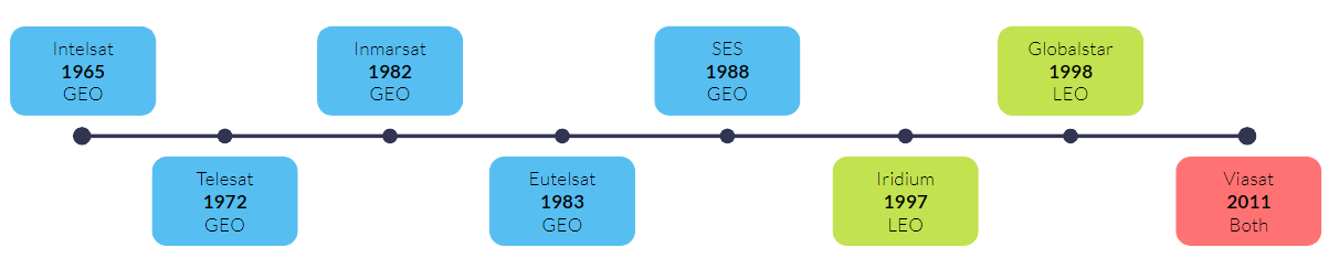
This timeline shows the launch dates of the “old guard” of satellite network operators; and while they’re unquestionably well established, don’t take old as meaning redundant here. These companies have stood the test of time; their services are highly reliable, and they’ve repeatedly updated their networks over the decades. Between them they serve the gamut of satellite internet applications, from Iridium’s Short Burst Data, designed for tiny amounts of IoT data, through to Viasat’s broadband internet service with speeds of up to 100 Mbps.
Satellite networks launched between 2018 and 2024
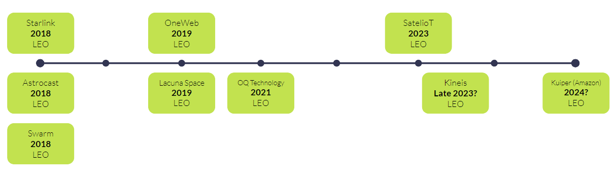
As mentioned, in recent years, more and more companies have started to build satellite networks; all are in Low Earth Orbit (LEO), and almost all are using what are called “SmallSats”. Here we’re using the term for any satellite weighing less than 180 kg and measuring between the size of a kitchen fridge and a Rubik’s cube. It’s this smaller size that has, in part, allowed for this growth – it’s much cheaper to put a SmallSat into Low Earth Orbit than it is to put a large satellite (over 1,000 kg) into Geostationary orbit.
Coupled with the trend for SmallSats and Low Earth Orbit, the other major reason for the increased number of new entrants is the lowered cost of putting satellites into space. From $85,000 per KG in the 1980s, to just $1,000 per KG in 2020 (source); for that you can largely thank SpaceX.
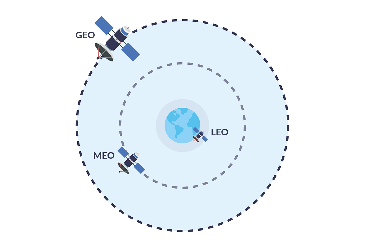
About satellite orbit heights
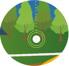
A quick explanation about the significance of orbit heights in satellite connectivity. Satellites in Low Earth Orbit (or LEO) are much closer to Earth than Geostationary satellites, which means that the time it takes to send data to the satellite and back to Earth is reduced – usually less than 1 second.
If you need real-time data transmission for your systems to operate smoothly, this is a welcome and necessary benefit. However, for this to be realized in practice, there needs to be a satellite overhead at the point at which you transmit; we’ll touch on the challenges new entrants have in this respect shortly.
What are the implications for water sensor manufacturers?
1. Lower cost
Firstly, cost: these networks cost less to establish, so the operators have less costs to recoup! That in turn has forced the established players to diversify their services to compete. This is great news as the relatively high cost of sending data over satellite previously made some use cases non-viable – but no longer. If you need to capture data from your remotely deployed sensors, cost is rarely, if ever, a prohibiting factor now.
Reservoirs
Water levels, precipitation, air and water temperature, relative humidity
Pipelines
Leak detection, Third Party Intrusion, broken wires, storm water ingress
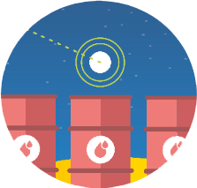
Treatment Plants
Water levels and flows, energy consumption, water quality, equipment status
2. Smaller antenna size
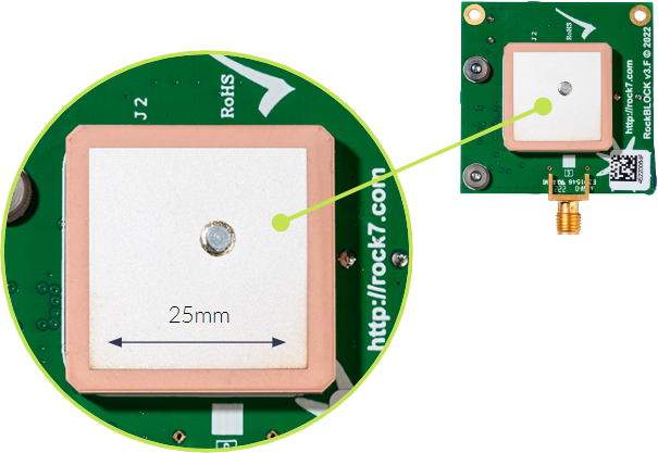
Secondly, antenna size and power. This has always been variable depending on the amount of data needing to be transmitted: a large amount needs a large antenna and a decent amount of power. Small amounts of sensor data, however, can be sent to satellites in Low Earth Orbit using absolutely tiny antennas such as the patch antenna included with the RockBLOCK 9603.
This connects to the Iridium network, which was one of the first LEO networks launched. This low-power-by-design modem can be powered by a battery for many years, and the same is true for many of the devices which connect to the new space entrants.
3. The convergence of satellite and 5G
The next step in the evolution of Satellite IoT is the convergence of cellular and satellite networks. The telecommunications industry is working on several ideas that will enable seamless data transfer between these networks. A key application of this convergence is to extend the reach of 5G which in comparison to its predecessors, provides limited coverage. If satellites can function as “cell towers” in space, it would unlock the full potential of 5G, providing global coverage from anywhere on the planet. 3GPP’s latest release – Release 17 – included technical specifications for direct-to-device 5G over satellite. This release also extended interoperability, Integrated Access and Backhaul (IAB), and network slicing to support Non-Terrestrial Networks (NTNs). Read more about 5G and satellite technology.
Things to be aware of
It’s not all good news, though. It takes time and money to build a reliable satellite constellation, and every one of the new entrants is still in the process of establishing their network – including Starlink and Swarm.
That means that you can suffer from high latency – i.e. there simply isn’t a satellite overhead for your device to send data to, so you will need to wait until there is. To give you a real-life example, if you connect your sensor to the Swarm network from North America, it can take from 2 minutes to 2 hours for your data to be intercepted by a satellite, and then delivered back to Earth. For Iridium, those parameters are 10 seconds to 15 minutes. And bear in mind Swarm (acquired by SpaceX in 2021) is one of the best established of the new entrants; newer and less well funded companies will have much longer delays.
Similarly coverage can be spotty; there is still only one satellite company that delivers 100% global coverage, and that’s Iridium. The established geostationary satellite operators usually have great coverage, and just miss out the polar regions.
The new networks also suffer from congestion: demand can outstrip supply, leading to failed transmissions and higher costs as data packets are re-sent; plus slower speeds when the network is busy. That’s plaguing Starlink right now – they’ll fix it, for sure, but just now it could be problematic.
However, if your instruments or sensors are within the coverage of one of these networks, and you can cope with receiving data once or twice a day, with the promise that this will speed up as they launch more satellites, then there is a huge amount of choice available to you, and the cost is really very low.
Our recommendations for water sensor satellite connectivity
For critical national infrastructure like water utilities, we continue to recommend established networks like Eutelsat, Iridium and Viasat with millions of subscribers, who’ve proven they can manage spikes in demand; who’ve got redundancy services baked in; who have very high levels of coverage and still benefit from very low latency.
- Low Earth Orbit
- 100% global coverage
- Network optimization and redundancy
- Low Earth Orbit
- 100% global coverage
- Network optimization and redundancy
- Geostationary Orbit
- 1,200 employees
- 40 years experience
What about data security?
“Water utilities are the third most targeted sector for hackers in the United States”
– Journal of Environmental Engineering
Water terrorism is on the rise and is likely to get worse as clean, safe water becomes an increasingly scarce resource. In 2022, hackers claimed to have access to the SCADA data of Thames Water (oddly, while they thought they’d hacked Thames Water, they’d actually hacked South Staffordshire Water; and in neither case were they actually able to access SCADA systems).
The hackers claimed to have the ability to tamper with the safety of drinking water, a terrifying prospect for the general public (source). While this incident blew over with basically no harm done, there are state-sponsored cyber warfare units who will be vastly more capable, should they be tasked with targeting national infrastructure.
To be clear, sending your data via satellite isn’t risk-free. But it is much harder to intercept data going from a sensor to a satellite, then back to a ground station, than it is to intercept data that’s using public infrastructure like the internet. And if that ground station is physically on your premises – that’s an air-gapped solution that’s about as secure as data transfer gets. This private satellite network is called TSAT and we don’t know of any more secure way to transmit mission critical data.
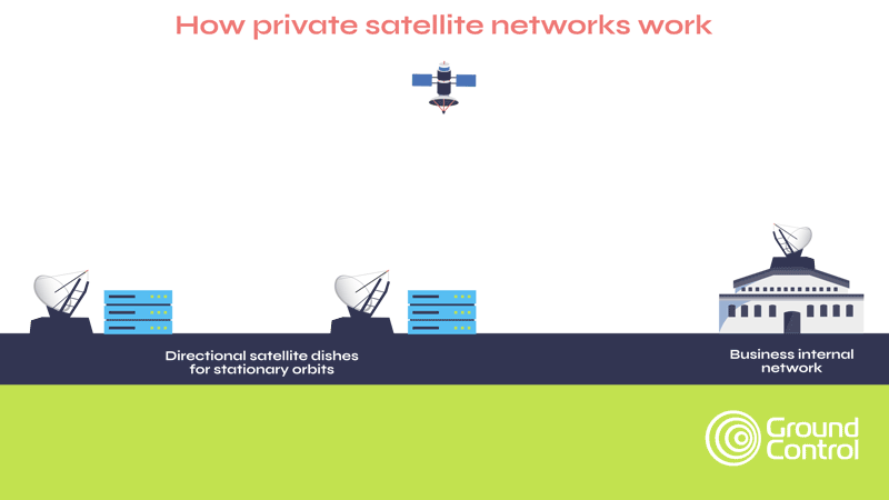
And while TSAT represents the highest tier of security capabilities within satellite IoT, by default, satellite data traffic is relatively secure, meeting most military and government security standards.
Further, at Ground Control, we’ve built Cloudloop, a delivery network for Iridium and Viasat traffic, which allows us to have full control over our certified, cutting-edge data paths, while securely delivering traffic.
We built this because we wanted to deliver additional security for our customers’ data, and offer optional public static IPs and completely configurable firewalls to assist in securely moving your data from A to B.
To summarize: satellite IoT has transformed in the last five years: prices have come down, transceivers are smaller, power requirements have lessened, and security has improved. And with Amazon’s Kuiper satellite network scheduled for launch in 2024, the pace of change is not going to slow.
We’re here to help you make sense of all of this. We keep on top of all of these developments so we can make expert recommendations to you, and ensure that a system you implement today will remain viable 5, 10 or 15 years into the future.

Would you like to know more?
We partner with sensor / instrumentation manufacturers to deliver end to end solutions for water companies across the world. If you design and build sensors, we’d love to hear from you to talk about working together. If you’re a water utilities company and looking for a connectivity bridge for your remote sites, we can help!
Call or email us, or complete the online form, and we’ll come back to you within one working day.